The National Parks Formed By Glaciers
A river cuts a narrow V. A glacier does something heavier. Moving ice grinds outward and down, quarrying rock from the valley walls and hauling it for miles, and what it leaves is the wide U-shaped trough under El Capitan, the fjords of coastal Alaska, the knife-edged ridges of Montana. Some of those glaciers melted thousands of years ago. A few are still moving. Either way, the shape of the land is what they left behind.
Glacier National Park, Montana

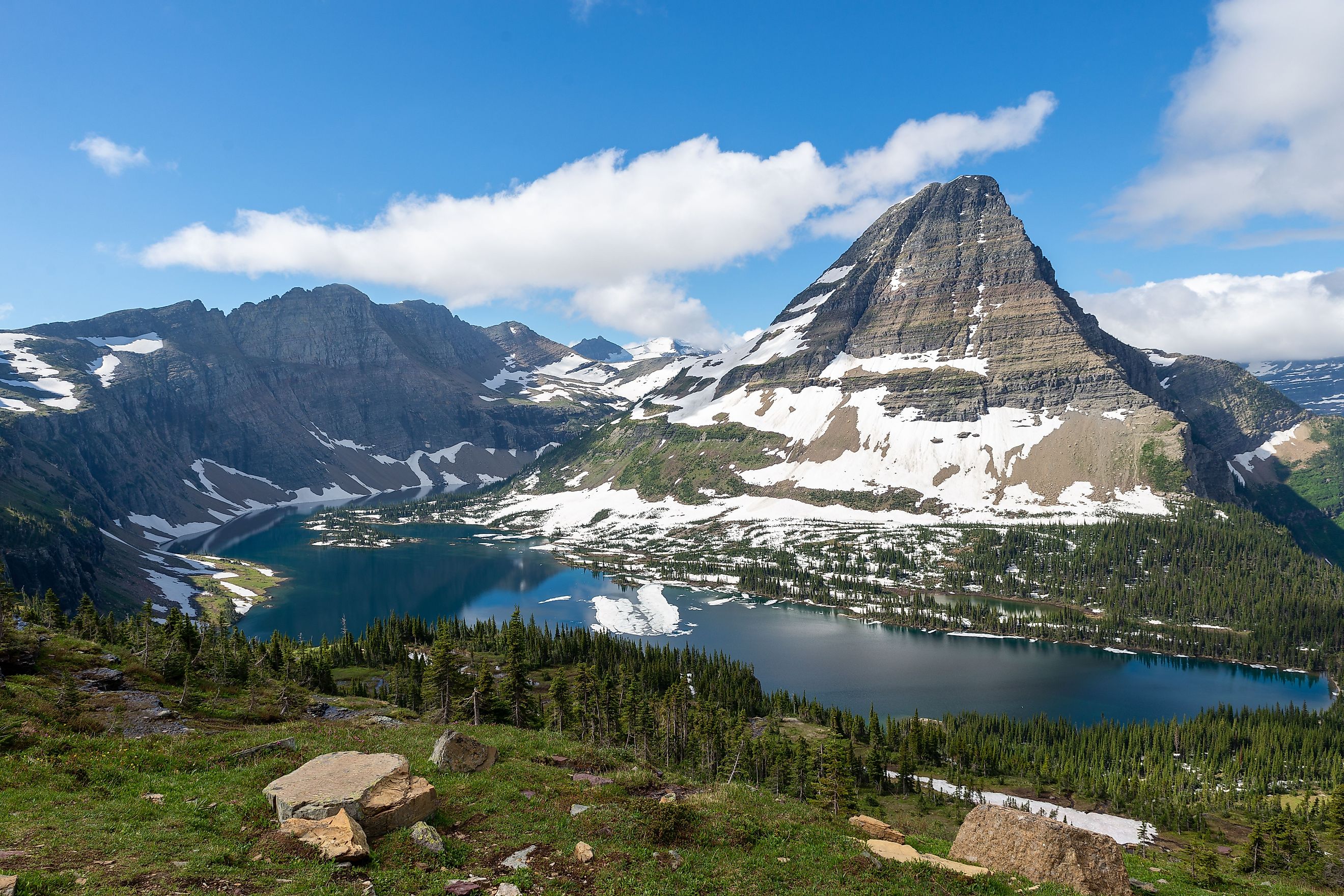
Glacier National Park contains one of the clearest records of Ice Age glaciation in the continental US. During the Pleistocene, large glaciers filled many of the park's valleys, leaving only the highest peaks above the ice. As they advanced and retreated, they carved broad U-shaped valleys and created cirques, moraines, and hundreds of lakes.
Many of the park's most recognizable landscapes reveal that history. St. Mary Lake sits within a glacially carved valley, while smaller alpine lakes occupy depressions carved by ice at higher elevations. Terminal moraines also dammed some valleys, helping create the long, narrow lakes found throughout the park.
The park's name can make it sound as though its glaciers are entirely ancient, but some modern glaciers remain. They are much smaller than the Ice Age glaciers that shaped the landscape. The broad valleys, knife-edged ridges, and steep mountain walls remain even where the ice that created them disappeared thousands of years ago.
Yosemite National Park, California

Yosemite Valley began as a much narrower river-cut canyon before glaciers repeatedly moved through the Sierra Nevada.
Over several million years, glaciers widened and deepened existing valleys, helping create Yosemite Valley's broad floor and steep granite walls. During one major glacial episode, ice in the valley may have reached thousands of feet in thickness.
Glacial erosion also explains Yosemite's waterfalls. The largest glaciers carved the main valleys deeper than the smaller glaciers in tributary valleys. When the ice disappeared, those tributary valleys were left hanging high above the main valley floor. Streams flowing through them now plunge over cliffs, creating waterfalls such as Bridalveil Fall.
Glaciers did not create Yosemite's granite or its original valleys. Instead, moving ice reshaped an existing landscape, helping produce the combination of cliffs, lakes, and waterfalls found throughout the park.
Grand Teton National Park, Wyoming

The Teton Range rose in part through movement along the Teton Fault, but glaciers transformed the mountains after they formed.
During the Pleistocene Ice Age, glaciers repeatedly moved through the range. They widened valleys into broad U-shaped canyons, sharpened high peaks, and gouged depressions that later filled with water. Lakes, including Jenny Lake and Taggart Lake, occupy landscapes shaped by that glacial activity.
The relationship between tectonic activity and ice remains visible throughout Grand Teton National Park, where faulting raised the range and glaciers reshaped the valleys below. Mountain glaciers carved canyons into the range and left behind moraines and outwash deposits that continue influencing the modern landscape.
Smaller glaciers remain in the Tetons today, although the massive Pleistocene glaciers disappeared about 10,000 years ago. Cascade Canyon, Death Canyon, and other valleys preserve evidence of the much larger glaciers that once occupied the range.
Rocky Mountain National Park, Colorado

Rocky Mountain National Park contains glacial evidence from its highest peaks to the bottoms of its valleys. Long after the largest glaciers disappeared, they left behind cirques, lakes, polished bedrock, moraines, and glacial erratics.
Before glaciation, streams had already cut V-shaped valleys into the mountains. As the climate cooled, snow accumulated at high elevations and compressed into moving ice. Those glaciers widened the valleys into the U-shaped forms visible throughout the park today.
Moraine Park is one of the clearest examples of what happened when the ice began to melt. Glaciers flowing from several valleys converged there before retreating and depositing rock along their sides and ends. Those deposits remain visible as lateral and terminal moraines.
Glacial erosion also created bowl-shaped depressions called cirques. Chasm Lake sits in one of these basins beneath the east face of Longs Peak.
North Cascades National Park, Washington

More than 300 glaciers and countless snowfields remain within North Cascades National Park, making the region the most heavily glaciated area in the US outside Alaska.
The present-day glaciers are only part of the story. Colossal ice sheets covered all but the highest peaks of the North Cascades as recently as 16,000 years ago. Over repeated glacial periods, moving ice gouged valleys, sharpened ridges, and helped create the steep, rugged topography that defines the range.
The mountains themselves have a complicated geological history. They consist partly of terranes, or distinct pieces of crust that formed elsewhere before becoming attached to North America. Tectonic forces raised and fractured those rocks, while erosion and glaciation sculpted them into the landscape visible today.
The glaciers did not build the North Cascades from scratch, but they certainly gave the mountains much of their modern shape.
Acadia National Park, Maine
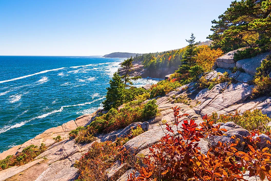
Acadia National Park is a different kind of glacial landscape. Instead of towering peaks and alpine valleys, its bedrock records the passage of massive continental ice sheets that moved across coastal Maine.
During the most recent glaciation, ice eroded Mount Desert Island, smoothing mountain tops, widening valleys, and carrying enormous quantities of rock across the landscape. The glaciers left behind scratches and grooves on exposed bedrock, along with glacial erratics: boulders transported by ice and deposited far from their original locations.
The glaciers also helped shape Acadia's coastline. Their immense weight depressed the land, and as the ice melted, seawater flooded low areas around the mountains. As the land later rebounded, the remaining mountains became part of the islands and coastal landscape visible today.
Jordan Pond occupies a valley shaped by glaciers and later influenced by glacial deposits. Throughout Acadia, smooth granite, rounded mountains, and scattered boulders provide evidence that ice once covered a landscape that now looks almost entirely different.
Kenai Fjords National Park, Alaska

In Kenai Fjords National Park, the work of glaciers is impossible to separate from the work of the ocean.
The Harding Icefield is one of the park's dominant geographic features and feeds dozens of glaciers, many of which terminate within park boundaries. Some carved deep valleys that were later flooded by seawater, creating the steep-sided fjords that the park is named for.
The park is a textbook case of one of the most striking forms of glacial erosion. When a glacier carves a valley deep enough below sea level, and the ocean later floods it, the result is a fjord.
Here, the glacial landscape is not simply evidence of the past. Moving ice continues to shape the environment.
Landscapes Written in Ice
Glaciers did not create every mountain, valley, or lake in these national parks. Tectonic forces raised the Tetons, ancient geological processes formed Yosemite's granite, and rivers had already carved valleys before many glaciers arrived.
Ice changed what was already there.
As glaciers advanced, they widened valleys, scraped bedrock, transported boulders, and carved depressions into mountainsides. When they retreated, they left behind moraines, lakes, polished rock, and landscapes that can still be read thousands of years later.
A U-shaped valley, a waterfall spilling from a hanging canyon, or a lake sitting beneath a steep mountain wall can all preserve part of that older story: one written by ice that once covered a very different version of the land.