What Was The Gondwana Supercontinent?
Gondwana was a supercontinent of the southern hemisphere that existed from about 600 million years ago until it broke apart in stages beginning around 180 million years ago. At its full extent it covered roughly 100 million square kilometers (about 39 million square miles) and included almost all of what are now the continents and large landmasses south of the equator: South America, Africa, the Arabian Peninsula, India, Madagascar, Australia, New Zealand, and Antarctica, as well as several smaller terranes now embedded in southern Europe and Southeast Asia. North America, by contrast, was never part of Gondwana; it was part of Laurentia, a separate ancient landmass in the northern hemisphere.
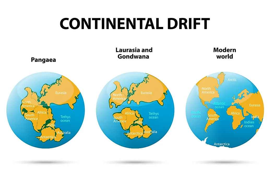
Gondwana itself was assembled from older continental fragments during the final stages of the Precambrian, then collided with Laurussia (the combined North American and northern European landmasses) about 335 million years ago to form the better-known supercontinent Pangaea. Pangaea persisted for roughly 135 million years before splitting along an east-west line back into Laurasia in the north and Gondwana in the south. From there, Gondwana itself fragmented into the southern continents in a series of rifts spanning the Jurassic, Cretaceous, and early Paleogene. The article below covers the naming and discovery of Gondwana, its assembly, its place within Pangaea, the fossil evidence that confirmed its existence, the staged breakup, and what remains of it today.
Origin of the Name and the Concept
The name Gondwana comes from the Gond region of central India, in what is now Madhya Pradesh and Chhattisgarh, where 19th-century British geologists working for the Geological Survey of India identified a distinctive sequence of sedimentary and coal-bearing rocks of Late Paleozoic to Mesozoic age. The Sanskrit roots translate roughly as "forest of the Gonds." H. B. Medlicott, a geologist with the Survey, applied the name "Gondwana System" to this rock sequence in the 1870s. The Austrian geologist Eduard Suess (1831 to 1914) then extended the name to the entire ancestral southern supercontinent in his multi-volume Das Antlitz der Erde (The Face of the Earth), published between 1885 and 1909. Suess used the term Gondwanaland; modern geology generally uses Gondwana, reserving Gondwanaland for the historical concept or for the Indian region that gave the supercontinent its name.
The matching shape of the coastlines of western Africa and eastern South America had been noted as early as 1620 by the English philosopher and statesman Francis Bacon (1561 to 1626), as new maps of the Atlantic became available in Europe. Bacon did not propose that the continents had once been joined; he only remarked on the visual fit. The full theory that the southern continents had once formed a single landmass was set out by the German meteorologist Alfred Wegener in his 1912 paper on continental displacement and developed further in his 1915 book Die Entstehung der Kontinente und Ozeane (The Origin of Continents and Oceans). Wegener's theory was rejected by most contemporary geologists, who could not accept a mechanism for moving continents, and continental drift remained a fringe idea for several decades. The South African geologist Alexander du Toit defended and extended the theory in his 1937 book Our Wandering Continents. The case for Gondwana was only fully accepted after the development of plate-tectonic theory in the 1950s and 1960s, when seafloor spreading at mid-ocean ridges supplied the missing mechanism.

Assembly of Gondwana
Gondwana did not exist all at once. It was assembled in stages from the fragmented remains of an even earlier supercontinent, Rodinia, which itself had broken apart between about 850 and 750 million years ago. The cratons (ancient, stable cores of continental crust) that would become India, Madagascar, eastern Africa, Antarctica, and Australia began to collide and merge during the Pan-African orogeny, a series of mountain-building events between roughly 600 and 530 million years ago. These collisions closed the Mozambique Ocean, an ocean that had once separated the eastern and western halves of the proto-Gondwanan continental fragments.
By about 550 to 540 million years ago, at the start of the Cambrian Period, Gondwana was substantially complete. The South American and African cratons had joined to form West Gondwana, and the Antarctic, Australian, Indian, and Madagascar cratons had joined to form East Gondwana, with the two halves welded together along sutures that today run roughly through eastern Africa. The completed supercontinent covered close to a fifth of the planet's surface area and sat across the south polar region. A long mountain chain called the Terra Australis Orogen, estimated at about 18,000 kilometers (11,000 miles) in length, developed along the western, southern, and eastern margins of the supercontinent, formed by subduction of oceanic crust along what is now the Pacific-facing edge of South America, Antarctica, and Australia. This margin remained tectonically active for hundreds of millions of years.
Gondwana Within Pangaea

About 335 million years ago, during the Carboniferous Period, Gondwana collided with Laurussia (also called Euramerica), the northern landmass formed by the earlier joining of Laurentia, Baltica, and Avalonia. The collision closed the Rheic Ocean between them and produced a chain of mountain-building events along the suture: the Alleghanian orogeny in eastern North America, the Variscan (or Hercynian) orogeny across western and central Europe, the Ouachita orogeny in the south-central United States, and the Mauritanide orogeny in northwestern Africa. The Appalachian Mountains of the eastern United States are remnants of this collision, as are the worn-down Variscan ranges of the Massif Central in France, the Ardennes, the Iberian Massif, and the Bohemian Massif. The resulting supercontinent, Pangaea, was largely complete by the late Permian, when Siberia and Kazakhstania had also joined along the Ural Mountains.
Pangaea was a single C-shaped landmass extending pole to pole and enclosing a vast eastern bay, the Tethys Ocean. The opposite, oceanic side of the planet was filled by the superocean Panthalassa, the ancestor of the modern Pacific. Gondwana formed the southern half of Pangaea throughout this period; Laurasia formed the northern half. The supercontinent lasted about 135 million years before tectonic forces began to pull it apart again along essentially the same line where Gondwana and Laurussia had collided in the first place.
Fossil and Geological Evidence

The case for Gondwana rests on several lines of evidence that match across what are now widely separated continents. The most famous is the distribution of the seed fern Glossopteris, a Permian plant whose fossils are found in identical Permian rock layers in South America, southern Africa, India, Australia, and Antarctica but nowhere in the northern continents. Mesosaurus, a small freshwater reptile of the early Permian, is found only in southern Brazil and southern Africa, in lake deposits that match across the now-separate continents. Lystrosaurus, a stocky Triassic therapsid (mammal-like reptile), is found in South Africa, India, and Antarctica. Cynognathus, another Triassic therapsid, occurs in both South America and southern Africa.
The geological evidence is equally strong. The Late Carboniferous to Early Permian glaciation left identical tillites (lithified glacial deposits) and grooved bedrock across the southern continents, all pointing toward what was then the south polar region in central Gondwana. Distinctive Precambrian rock formations match across the Atlantic between Brazil and Gabon. The Cape Fold Belt of South Africa connects geologically to the Ventana Mountains of Argentina, and the Eastern Ghats of India share a Precambrian terrane with the Antarctic Prince Charles Mountains. These matches were impossible to explain by parallel evolution or land bridges and provided the body of evidence that finally turned continental drift, after decades of skepticism, into the foundation of modern earth science.
Breakup of Gondwana

The fragmentation of Gondwana began around 180 million years ago, in the Early Jurassic, with the opening of rifts between what are now Africa and Antarctica and between South America and Africa. The first major split, around 170 to 165 million years ago, separated West Gondwana (Africa plus South America) from East Gondwana (Antarctica plus Madagascar plus India plus Australia), opening the western Indian Ocean between them. Massive volcanic outpourings called the Karoo-Ferrar large igneous province, dated to about 183 million years ago, marked the initial rifting and left flood basalts across southern Africa and Antarctica.
South America began to peel away from Africa starting about 140 to 130 million years ago, in the Early Cretaceous, opening the South Atlantic Ocean progressively northward along a rift that today forms the Mid-Atlantic Ridge. India, together with Madagascar, broke from Antarctica at roughly the same time and began drifting north. Madagascar and India separated from each other around 88 million years ago, in the Late Cretaceous, leaving Madagascar as a long island off the East African coast. The Seychelles microcontinent, a fragment of the Indian continental crust, broke off from India about 66 million years ago.
India then drifted north across the Tethys Ocean at one of the fastest rates ever recorded for a continent, around 15 to 20 centimeters per year, and collided with the southern margin of Asia roughly 50 million years ago, beginning the uplift of the Himalayas and the Tibetan Plateau that continues today. Australia separated from Antarctica around 45 million years ago and has been drifting north toward Southeast Asia ever since at about 7 centimeters per year. The Drake Passage between South America and Antarctica opened around 30 to 23 million years ago, completing the breakup and isolating Antarctica with a circumpolar current that allowed the continent to ice over for the first time in tens of millions of years.
What Remains of Gondwana Today
The modern southern continents are the direct descendants of Gondwana. South America, Africa, the Arabian Peninsula (which split from Africa more recently, around 25 million years ago, opening the Red Sea), India, Madagascar, Australia, New Zealand, and Antarctica all carry distinctive rocks, fossils, and biological lineages that trace back to the supercontinent. Several smaller pieces, called peri-Gondwanan terranes, are now embedded in other continents: parts of the Iberian Peninsula, much of southern Italy, the Greek mainland and Balkan terranes, parts of Turkey and Iran, the Indochinese Peninsula, and Florida and adjacent parts of the southeastern United States all originated as Gondwanan fragments that broke off and accreted onto Laurasian continents during the long Pangaea era.
The biological signature of Gondwana is still readable today. The southern beech (Nothofagus) is found in southern South America, New Zealand, Australia, Tasmania, and New Guinea, but nowhere in the northern hemisphere, a distribution that reflects the trees' Gondwanan ancestry. Marsupial mammals are concentrated in Australia and South America, with no surviving wild marsupials in Africa, because their ancestors radiated across the Gondwanan landmass before Africa split off. Ratite birds (ostriches in Africa, rheas in South America, emus and cassowaries in Australia, kiwis in New Zealand, and the extinct moas and elephant birds of New Zealand and Madagascar) all share a Gondwanan origin.
Timeline of Gondwana
| Approximate Date | Event |
|---|---|
| 600 to 530 million years ago | Pan-African orogeny welds the cratons of Africa, South America, Antarctica, Australia, India, and Madagascar into Gondwana. |
| 540 million years ago | Gondwana is substantially complete; the Cambrian explosion of complex life begins. |
| 335 million years ago | Gondwana collides with Laurussia to form Pangaea. The Appalachian and Variscan mountain ranges rise. |
| 250 million years ago | End-Permian mass extinction occurs while Pangaea is fully assembled. |
| 183 million years ago | Karoo-Ferrar volcanic province erupts; rifting begins in southern Africa and Antarctica. |
| 180 million years ago | Gondwana begins to break up; East and West Gondwana separate. |
| 140 to 130 million years ago | South Atlantic Ocean opens. Africa and South America separate. |
| 88 million years ago | Madagascar and India separate. |
| 66 million years ago | Seychelles microcontinent splits from India. |
| 50 million years ago | India collides with Eurasia; uplift of the Himalayas begins. |
| 45 million years ago | Australia separates from Antarctica. |
| 30 to 23 million years ago | Drake Passage opens between South America and Antarctica; Antarctica ices over. |
| 25 million years ago | Arabian Peninsula begins to rift from Africa; Red Sea opens. |
What Gondwana Left Behind
The story of Gondwana is in one sense the story of how the southern hemisphere came to look the way it does. The distribution of mountain ranges along the western edges of South America and the eastern edges of Australia and Antarctica reflects the long subduction history of the Terra Australis margin. The coal seams of India, Australia, and South Africa formed in the same Permian forests of Glossopteris that produced the coal of Antarctica. The South Atlantic Ocean exists at all because Africa and South America pulled apart along the Cretaceous rift. The Himalayas are still rising because India has not stopped moving north. And the icy isolation of Antarctica, more than any other single fact, is a direct consequence of when and how Gondwana came apart. The southern continents are not separate stories; they are pieces of the same story.