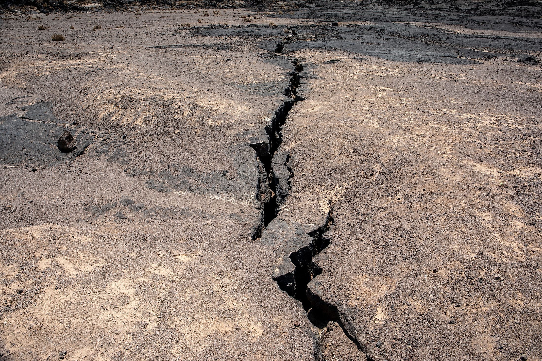
Is Africa Splitting into Two Continents?
The earth's surface is not static; it is a constantly changing landscape shaped by the movements of the underlying tectonic plates. The theory of plate tectonics has revolutionized our understanding of the earth's geological processes, including the formation of continents, mountains, volcanoes, and earthquakes. One of the most intriguing questions posed by this theory is whether Africa is in the process of splitting into two continents; growing evidence suggests that, yes, world maps will eventually look very different. Volcanic eruptions in 2005 initiated the theory of Africa's split, and cracks forming in Kenya in 2018 confirmed the suspicion.
The African continent, situated on the African Plate, is experiencing significant geological changes due to the movements of the surrounding tectonic plates. The most notable of these changes is the ongoing formation of the East African Rift System due to the slowly separating Nubian and Somali tectonic plates. This rifting process has been taking place for millions of years. It is gradually widening the rift valley, potentially splitting Africa into two separate landmasses and leaving space for a brand new ocean — free of charge.
Background On Plate Tectonics
Plate tectonics is the scientific theory that explains the large-scale movements of the earth's lithosphere, which is divided into several tectonic plates. These plates, comprised of both continental and oceanic crust, float atop the semi-fluid asthenosphere and interact with one another through various types of boundaries. The movement of tectonic plates is driven by forces such as mantle convection, gravitational sliding, and ridge-push and slab-pull mechanisms.

The idea that continents move across the earth's surface was first proposed by German meteorologist Alfred Wegener in 1912. He called this phenomenon "continental drift" and suggested that all the continents were once part of a single supercontinent called Pangaea, which began to break apart around 200 million years ago. However, Wegener's theory lacked a plausible mechanism to explain the movement of continents and was met with skepticism by many scientists.
In the 1950s and 1960s, extensive mapping of the ocean floor revealed the existence of mid-ocean ridges, which are vast underwater mountain ranges formed by the upwelling of magma from the earth's mantle. This groundbreaking discovery provided essential clues about the movement of tectonic plates and contributed to the development of the theory of plate tectonics. Scientists discovered that new oceanic crust is created at the mid-ocean ridges through seafloor spreading, pushing the tectonic plates apart.

The theory of plate tectonics was developed in the late 1960s, building on the discoveries of continental drift and mid-ocean ridges. This theory combined the ideas of continental drift and seafloor spreading to explain the movement of the earth's lithosphere comprehensively. Plate tectonics not only explained the formation and movement of continents but also accounted for various geological phenomena such as earthquakes and volcanic activity.
The East African Rift System

The East African Rift System (EARS) is a complex and vast geological feature that stretches over 1,860 miles from the Afar Triple Junction in the north to the Mozambique border in the south. It passes through several African countries, including Ethiopia, Kenya, Tanzania, Uganda, and Malawi.
The Somalian Plate is located east of the East African Rift System and moving eastward away from the Nubian Plate. The separation of these two plates is causing the formation of the rift valley and contributing to the extension of the continental crust. The adjacent movements of the Arabian plate are also a contributing factor.
The Nubian Plate encompasses most of the African continent and is situated west of the EARS. As the Nubian and Somalian plates continue to diverge, the rift system expands, potentially splitting the African continent.

The EARS is associated with significant volcanic activity due to the interaction of the tectonic plates and the upwelling of magma from the mantle. Some of the most notable volcanoes in the region include Mount Kilimanjaro, Mount Kenya, and the Virunga Mountains, home to critically endangered mountain gorillas.
The EARS is also characterized by frequent seismic activity, including earthquakes, as the tectonic plates continue to diverge. Scientists and seismologists closely monitor the region to better understand the processes involved in the splitting of the African continent.
The Process Of Africa Splitting

Mantle plumes, upwellings of hot material from deep within the earth's mantle, play a critical role in separating the African continent. These plumes cause the crust to weaken and thin, allowing the tectonic plates to stretch and separate.
The separation of the tectonic plates has a profound impact on the landscape of the EARS, resulting in the formation of the Great Rift Valley and the creation of new lakes, rivers, and other geological features.
As the rift valley continues to widen, inland seas and lakes are forming in the depressions created by the stretching of the earth's crust. Over time, these water bodies could potentially merge and give rise to a new ocean. The process of ocean floor spreading, which is the creation of a new oceanic crust at mid-ocean ridges, will likely contribute to forming a new ocean in the EARS. As the rift valley widens, the ocean floor spreading will help facilitate the widening of the new ocean basin.

The separation between the Nubian and Somalian plates (as well as the adjacent Arabian plate) has been ongoing for approximately 25 million years, with the EARS gradually widening and deepening over time. It is estimated that it will take another 5 to 10 million years for the formation of a new ocean in the EARS. However, this timeline is subject to change.
Consequences Of The Split
The splitting of Africa would result in the formation of two new continents, significantly reshaping global geography. The new continents would be separated by an ocean, which would not only alter the existing landmasses but also lead to the creation of new coastlines and marine environments.
The splitting of the African continent would have a cascading effect on global plate tectonics, as it would influence the movement and interaction of other tectonic plates around the world. This could lead to changes in the frequency and intensity of geological events, such as earthquakes and volcanic activity, in other regions.
The formation of a new ocean and the subsequent separation of the African continent would likely significantly impact global climate patterns. The new ocean could alter ocean currents and atmospheric circulation, potentially leading to changes in temperature, precipitation, and storm patterns. These climate shifts could have far-reaching effects on ecosystems, agriculture, and human populations.

The splitting of Africa would result in significant habitat changes for many species, as new environments would be created and existing ecosystems would be disrupted. This change could lead to shifts in biodiversity as species adapt to the changing landscape or migrate to more suitable habitats. The process could also create opportunities for the emergence of new species, as well as the potential extinction of others.
The splitting of the African continent would have significant implications for the distribution of natural resources, such as water, minerals, and arable land. As new geological features emerge and existing ones are altered, access to these resources may change, potentially leading to competition and conflict among nations.
The ongoing geological processes in the East African Rift System, driven by the movement of the Somalian and Nubian tectonic plates, are ultimately too far in the future to worry modern concerns. Over time, the African Continent will split into two. As millions and billions of years occur, the two landforms may merge back together again as they have already done in previous iterations of ancient supercontinents. Regardless, as this geological event is ongoing, it is therefore measurable and potentially useful for studies that could help predict earthquake disasters, saving countless lives.


