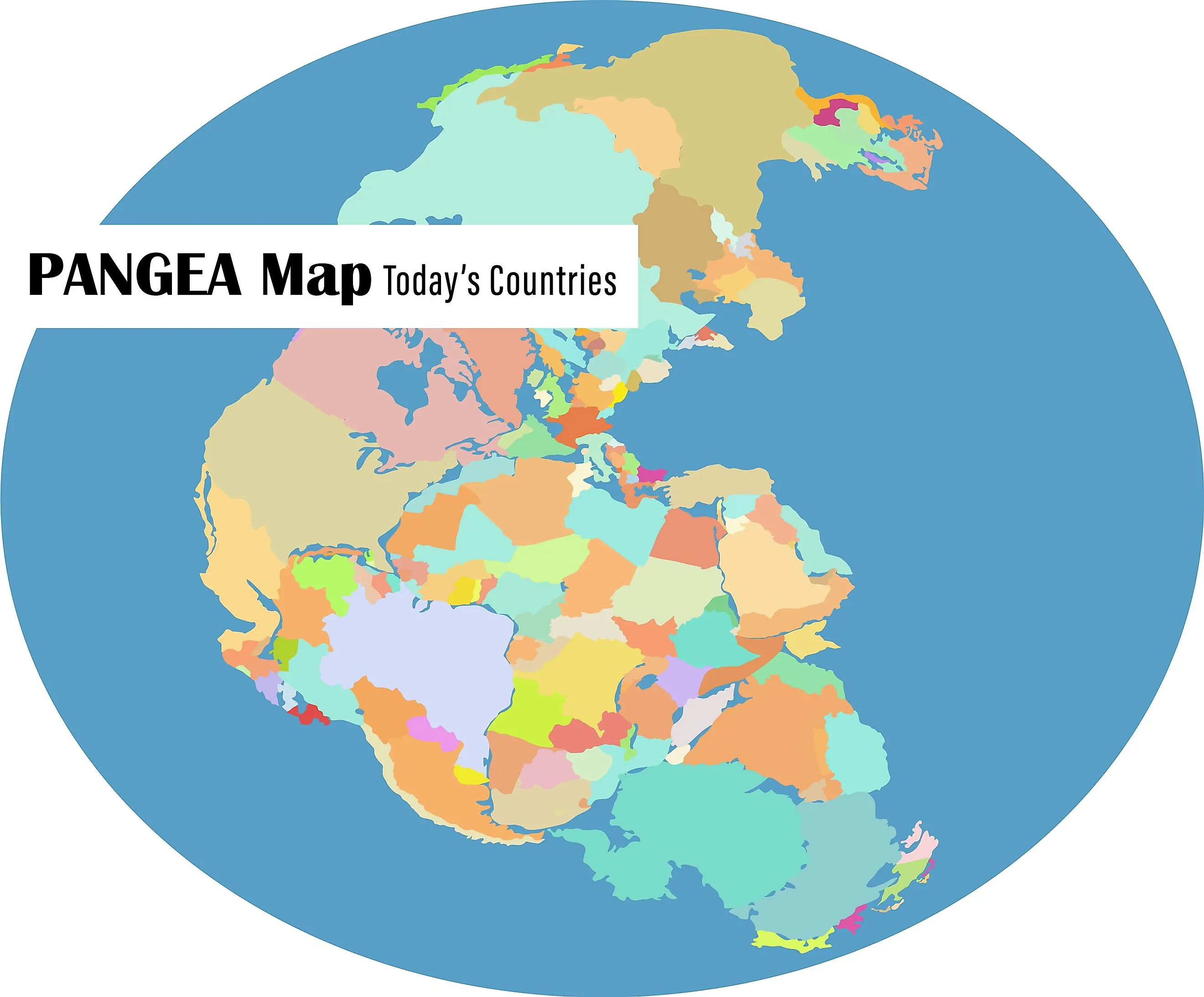
Pangea
Geologists define a supercontinent as a congregation of all the continental blocks of the Earth resulting in the formation of a single expansive landmass. Many such supercontinents have formed and broken up several times throughout the Earth’s 4.5 billion years, dramatically altering the planet’s history. The Afro-Eurasian landmass, which presently occupies more than 57% of the planet’s total land area, closely fits the modern definition of supercontinents. It is believed that about 336 million years ago, during the end of the Paleozoic and the beginning of the Mesozoic Eras, there was a supercontinent named Pangea or Pangaea. All major continents of that time were gathered into the supercontinent of Pangaea, which eventually fragmented, giving rise to the Earth’s present-day continents. This makes Pangaea the latest supercontinent to have existed and the first that geologists have successfully reconstructed based on the geologic records.
Origin Of The Concept Of Pangaea

The term “Pangaea” has been derived from the Greek words, ‘pan’ which means “entire,” and ‘gaea’ or ‘Gaia’ which means “Mother Earth.” The well-known German meteorologist Alfred Wegener in his 1912 publication, “The Origin of Continents,” first hypothesized that the ancient continents formed a contiguous land mass. In his 1915 publication, “The Origin of Continents and Oceans,” Wegener expanded his previous hypothesis and proposed that before the fragmentation and drifting of the continents to their present-day positions, all the continents formed a part of an immense supercontinent which he named “Urkontinent.” In the 1920 edition of his previous publication, Wegener called the ancient supercontinent “the Pangaea of the Carboniferous.”

In November 1926, after a symposium organized by the American Association of Petroleum Geologists, the term “Pangaea” became a part of German and English scientific literature. Wegener initially believed that the fragmentation of Pangaea was brought about by the centripetal forces caused by the Earth’s rotation, which acted upon the high continents. However, this mechanism was found to be physically unrealistic, further delaying the Pangaea hypothesis's scientific acceptance. The mechanism of mantle convection was proposed by the notable English geologist Arthur Holmes along with the evidence about the ocean-depth profiles collected by sonar-equipped vehicles which traveled across the oceans after World War II. This led to the further development of the widely-accepted plate tectonics theory, which satisfactorily explained Pangaea’s existence and breaking up.
Formation Of Pangaea

Various geological studies have revealed that about 335 million years ago, during the Carboniferous period, the supercontinent of Pangaea began to form from the congregation of previous continental units, such as Laurasia, Gondwana, and Siberia or Angaraland. A significant portion of this supercontinent was centered on the Equator and surrounded by a superocean named Panthalassa. Though Pangaea initially formed 335 million years ago, it was not the first continental form. Many such supercontinents like this have existed before, and Pangaea is therefore believed to have been formed by the fusion of ancient continents. This is ascertained by the fact that for billions of years, the continents and tectonic plates have been constantly in motion, either coming closer or drifting apart.
Approximately 2.0 to 1.8 billion years ago, the fourth-last supercontinent, named Columbia, began to assemble. Columbia broke up about 1.26 to 0.90 billion years ago, while its fragments' accretion and assembly led to the formation of the next supercontinent Rodinia. This Mesoproterozoic and Neoproterozoic supercontinent broke up around 750 to 633 million years ago, splitting into Proto-Laurasia, Proto-Gondwana, and Congo Craton. The ancient Proto-Tethys Ocean separated Proto-Laurasia and Proto-Gondwana. In due course, Proto-Laurasia split to form the continents of Baltica, Laurentia, and Siberia. Two new oceans, namely the Paleoasian and Iapetus oceans, were also formed due to this splitting. The landmasses mentioned above soon assembled and formed the supercontinent of Pannotia.

The supercontinent of Pannotia was relatively short-lived and existed until the start of the Cambrian Period, after which it broke up, leading to the creation of Baltica, Laurentia, and the supercontinent of Gondwana. The continent of Laurentia, which was placed on the Equator during the Cambria period, was bordered by the Iapetus Ocean in the south, the Panthalassic Ocean in the north and west, and the Khanty Ocean in the east. At the beginning of the Ordovician period, a microcontinent named Avalonia separated from Gondwana and started its journey toward Laurentia. By the end of the Ordovician period, the Iapetus Ocean began to close as Avalonia, Baltica, and Laurentia joined to form Laurussia or Euramerica. The Khanty Ocean separated Siberia from Euramerica, while Gondwana drifted further towards the South Pole.
Southern Europe separated from Gondwana about 430 million years ago, in the middle of the Silurian period, and started to move across the Rheic Ocean towards Euramerica. Southern Europe collided with the southern part of Baltica during the Devonian period. By the end of the Silurian period, the splitting of the South China Craton and Annamia from Gondwana resulted in the shrinking of the Proto-Tethys Ocean and created the Paleo-Tethys Ocean in the south. With the shrinking of the Rheic Ocean during the Devonian period, Gondwana started moving towards Euramerica. During the Carboniferous period, the collision of northwest Africa with Euramerica’s southeastern coast resulted in the formation of the Mauritanide Mountains, the Meseta Mountains, and the southern part of the Appalachian Mountains. In addition, South America moved towards Southern Euramerica, whereas Gondwana’s eastern portion moved towards the South Pole.

In the Late Carboniferous period, the collision of Baltica with the western part of the Kazakhstania microcontinent resulted in the closure of the Ural Ocean and the western Proto-Tethys, forming the Ural Mountains and the supercontinent of Laurasia. On the other hand, the collision of South America with the southern part of Laurentia led to the closure of the Rheic Ocean and the formation of the Ouachita Mountains and the southernmost portion of the Appalachians. During this period, Gondwana positioned itself close to the South Pole, and with the collision of Siberia with the North China block, the Proto-Tethys Ocean close completed by the beginning of the Jurassic Period.
The Cimmerian Plate split off from Gondwana during the Early Permian period and moved towards Laurasia, closing the Paleo-Tethys Ocean and creating the Tethys Ocean. Finally, a significant collision between Gondwana, Laurasia, and the intervening terranes led to the formation of the Pangaea supercontinent. A major portion of this C-shaped supercontinent stretched between the northern and southern polar regions of the Earth. The curve of the supercontinent’s eastern edge contained the Tethys Ocean, which was formed after the Cimmerian superterrane rotated northwards and split from northern Gondwana.
Climate Of Pangaea
The single massive landmass of Pangaea featured a high degree of climatic variability. For example, the interior part of the supercontinent experienced an arid climate with short rainy seasons. The far distance from the ocean led to the creation of vast deserts at the heart of the supercontinent, while seasonal climates with rainy summers and dry winters were experienced in the coastal areas. The superocean Panthalassa’s equatorial waters were mostly cut off from the cold ocean currents, as the Paleo Tethys and Tethys Oceans formed a huge warm water sea, in turn affecting the supercontinent’s climate. Moreover, the formation of Pangaea led to the disruption of the intertropical convergence zone, thereby leading to the creation of an extreme monsoon climate referred to as the “Pangean megamonsoon.”
Life In Pangaea
From its formation around 335 million years ago to its breakup around 175 million years ago, the supercontinent of Pangaea existed for about 160 million years. During this entire period, some critical developments in the evolution of life on Earth took place. In the Early Carboniferous, the seas were filled with bryozoans, horn corals, brachiopods, and the earliest Osteichthyes. The lycopsid forests on land were dominated by various arthropods and the first tetrapod. During the Permian period, insects like beetles and dragonflies appeared along with synapsids – the predecessor of mammals. In the Middle Jurassic, the seas were filled with ammonoid molluscs, sharks, ichthyosaurs, rays, and the earliest form of ray-finned bony fishes. On land, the dinosaurs flourished in the conifer and cycad forests.
The absence of oceanic barriers in Pangaea favored cosmopolitanism, where the most dominant species attained wide geographical distribution. However, it is to be noted that Pangaea witnessed two most destructive mass extinction events in Earth’s history: the Permian-Triassic extinction event and the Triassic-Jurassic extinction event.
Breaking Up Of Pangaea

It is estimated that the supercontinent Pangaea started breaking apart approximately 175 million years ago. This breaking and splitting apart of the massive supercontinent took place extremely slowly in different phases, with the gradual appearance of rifts and fissures. Volcanic activities in the Earth’s mantle led to the formation of these rifts and fissures, which pushed the landmasses away from each other. It is this movement that led to changes in the Earth’s landscape and formed its major geological features. As the pattern of seafloor spreading indicates, all of Pangaea did not break up at once but occurred along distinct rifts in three major phases.
Phase One
The initial breakup of Pangaea started during the late Ladinian age, about 230 million years ago, with the opening of the central Atlantic. About 175 million years ago, during the Early-Middle Jurassic period, Pangaea began to separate from the Tethys Ocean in the east to the Pacific in the west. As a result of this, several failed rifts were produced along this line. As North America started moving away from Africa, one of these rifts resulted in the creation of the North Atlantic Ocean. In the Cretaceous period, the opening of the South Atlantic led to the northward movement and clockwise rotation of Laurasia. This later led to the closing of the Tethys Ocean and the widening of the Sinus Borealis, which eventually became the Arctic Ocean. At the same time, new rifts that formed along the margins of Antarctica, Madagascar, and the eastern coast of Africa, created the Indian Ocean.
Phase Two
During the Early Cretaceous period, the second major phase in the breakup of Pangaea began with the breaking of the Gondwana landmass into several continents: South America, Africa, India, Australia, and Antarctica. Subduction along the Tethyan trench caused the northward movement of Africa, India, and Australia, finally creating the South Indian Ocean. At the same time, Atlantica containing present-day Africa and South America, split from the eastern part of Gondwana, creating the South Atlantic Ocean.
The separation of Madagascar and India from Antarctica and its eventual northward movement created the Indian Ocean. During the Late Cretaceous, Madagascar and India separated from each other, while India continued its northward journey toward Eurasia, further closing the eastern Tethys Ocean and creating the mighty Himalayan mountains. Small fractures in the east began separating New Zealand and New Caledonia from Australia, leading to the opening of the Coral and the Tasman seas.
Phase Three
The third and final breakup of Pangaea, which began in the early Cenozoic period, shaped the map of the world as we all know it today. This phase witnessed the splitting apart of Laurasia into Laurentia (containing North America and Greenland) and Eurasia. This split resulted in the creation of the Norwegian Sea about 60 to 55 million years ago. At the same time, Australia also separated from Antarctica and moved northwards. This northward movement of Australia is continuing even today, and it is expected that Australia will eventually collide with Eastern Asia.
The northward movement of South America after separating from Antarctica allowed the complete oceanic circulation around Antarctica for the first time. This movement, along with a reduction in atmospheric carbon dioxide concentrations, allowed the formation of glaciers in Antarctica. The breaking up of Pangaea continues to this date, as can be seen in the East African Rift and the Red Sea Rift.
Just like fitting the different pieces of a giant jigsaw puzzle, geologists can ascertain the different fractures and rifts that broke apart the once single expansive landmass of Pangaea into various parts, which gradually changed directions, moved apart, and connected in due course. However, this breaking apart of Pangaea is still in progress, and it is believed that plate tectonics will again change the surface features of our planet in the near future.


