El Morro: Castle Ruins Of Puerto Rico
- El Morro is Puerto Rico's most popular historic site.
- It is is a large fortress that dates back to the 16th century.
- El Morro was designated a UNESCO World Heritage Site in 1983.
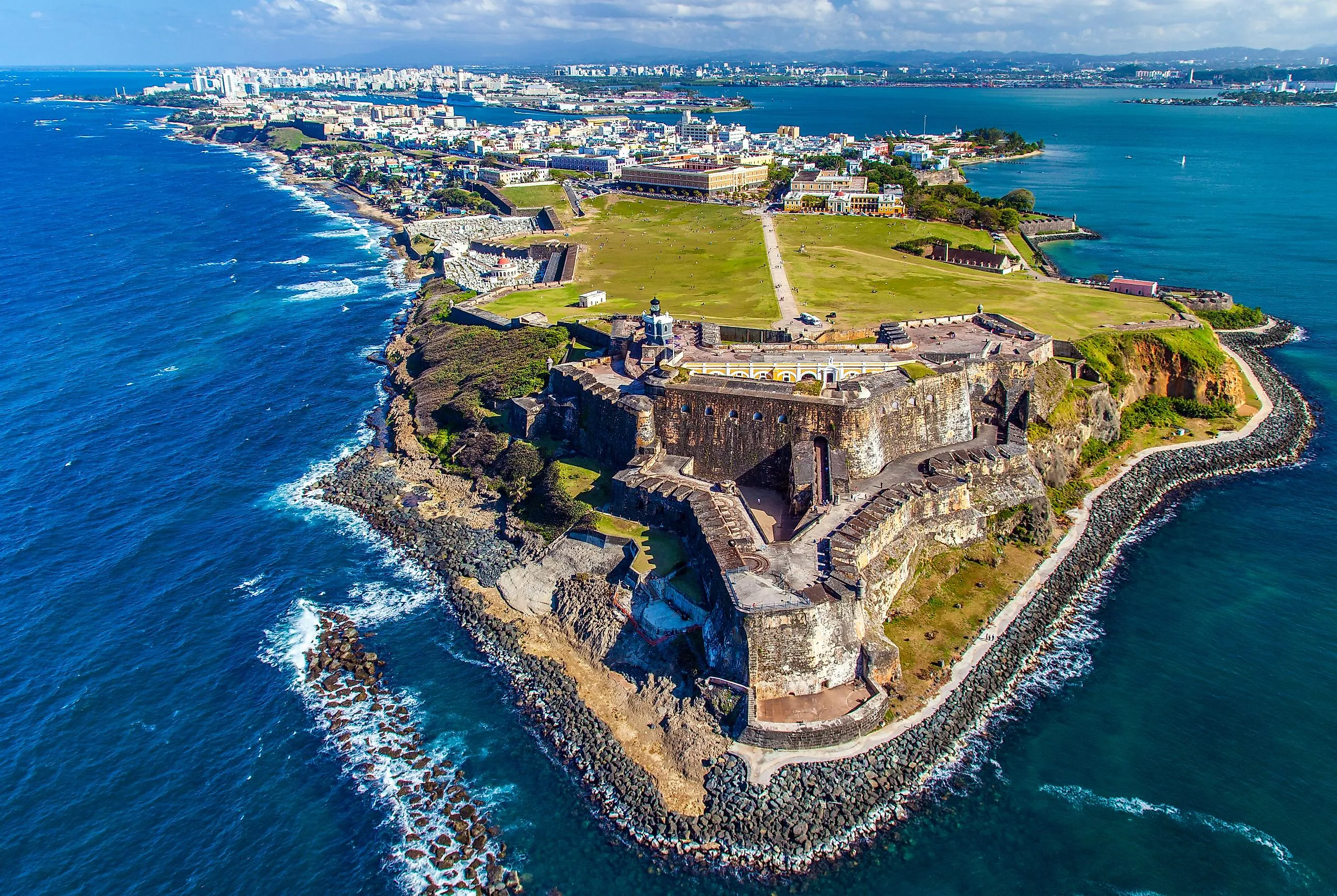
For over three centuries, the great Spanish fortress at the mouth of San Juan Bay was never taken by an attacking fleet. Five major naval assaults tried (the first by Sir Francis Drake himself in 1595, the last a US Navy bombardment in 1898), and the fortress walls turned every one of them back. Castillo San Felipe del Morro, almost universally just called El Morro, is the six-level stone fort that did the work: a 27-acre complex rising 145 feet above the Atlantic, with walls 18 feet thick at the seaward base. Construction began in 1539 under orders from Spanish king Charles V and continued in stages through six generations of Spanish military engineers, reaching its current form around 1787. The fort was named a UNESCO World Heritage Site in 1983 as part of the broader La Fortaleza and San Juan National Historic Site listing, and the US National Park Service has run it since 1961.
A 250-Year Building Project
Construction began in 1539 on orders from Spanish king Charles V (Charles I of Spain), who recognized San Juan Bay's strategic value as a deep harbor commanding the eastern approaches to the Caribbean. The first major phase, supervised by Captain Diego Méndez de Valdés, established the lowest gun platform at the water's edge by the 1570s. The Italian-born military engineer Juan Bautista Antonelli arrived in 1589 and redesigned the upper works using the latest Renaissance bastion-fort principles, adding the great central courtyard and the angled outer walls designed to deflect incoming cannon shot rather than catch it head-on. Subsequent Spanish engineers continued the project across the 17th and 18th centuries, with the final major additions (the seaward outworks and the connection to the rest of San Juan's defensive walls) completed under Irish-born engineer Tomás O'Daly and his successor Juan Francisco Mestre by 1787. By the time the Spanish were finished, El Morro covered 27 acres, rose 145 feet above the Atlantic at its highest point, and contained six levels of barracks, magazines, dungeons, water cisterns, and gun emplacements.
Every Naval Attack Failed
El Morro faced five recorded major attacks during its three and a half centuries as a Spanish fortress, and not one of them succeeded as a direct naval assault. Sir Francis Drake arrived in 1595 with 27 ships, the year before his own death, and was driven off by gunfire from the fort and from the Spanish galleons in the bay; one cannonball reportedly struck Drake's flagship cabin while he was at dinner, knocking the stool out from under him without finding its target. George Clifford, the Earl of Cumberland, captured San Juan in 1598 by landing east of the city, marching overland, and besieging the city from the rear; the Spanish garrison surrendered, but Cumberland's force was forced to abandon Puerto Rico within about 65 days after dysentery killed several hundred of his men. Dutch admiral Boudewijn Hendricksz attempted a similar overland approach in 1625 and burned much of San Juan to the ground before retreating empty-handed. British general Sir Ralph Abercromby attacked in 1797 with 60 ships and roughly 8,000 men, and was turned back at the city walls.
The fifth and final attack came on May 12, 1898, during the Spanish-American War, when US Navy Admiral William T. Sampson's fleet shelled El Morro from offshore. The bombardment damaged the upper works but failed to break the fortress, and Spain ultimately ceded Puerto Rico to the United States through the Treaty of Paris signed on December 10, 1898, rather than through direct military conquest. In other words, El Morro never fell to a fleet during the entire 359-year Spanish period; it changed hands by diplomacy, not by siege.
Garitas, Eighteen-Foot Walls, and the Famous Color Scheme

El Morro's most photographed architectural feature is the set of small domed sentry boxes called garitas, which cantilever out from the corners of the upper walls so guards could see along the wall faces without exposing themselves to fire. The garitas have become a Puerto Rican national symbol, appearing on the standard Puerto Rico license plate, on tourism materials, and on the trademark image used to identify San Juan in films, on postcards, and on Puerto Rican rum bottles around the world. The main walls reach 18 feet thick at the seaward base and taper toward the top; they are built almost entirely of cut sandstone bonded with a lime-sand-brick-dust mortar that proved remarkably resistant to cannon shot. The six levels descend more than 140 feet from the upper artillery platforms down to the water-level Santa Bárbara battery, connected by interior stairs, ramps, and a chapel. The exposed seaward face was painted in a striking red-and-yellow color scheme through much of the 18th century, faded to plain stone by the 20th, and has been partially restored to its colored appearance in recent NPS preservation work.
From Spanish Fort to American Park

Puerto Rico passed to American sovereignty under the December 10, 1898 Treaty of Paris ending the Spanish-American War, and El Morro along with it. The US Army took over the fortress and ran it as a working military post named Fort Brooke until 1961. During World War II, the upper levels were modified with concrete fire-control bunkers used to spot German U-boats operating in the Caribbean (a tactical mission that the fort had been originally built four centuries earlier to perform against an entirely different generation of naval threat, with telescopes replacing the cannon). El Morro was named a US National Historic Site in 1949, transferred from the Army to the National Park Service in 1961, and folded into the present San Juan National Historic Site. In 1983, UNESCO added the fort (along with La Fortaleza, the city walls, and the larger Castillo San Cristóbal across Old San Juan) to its World Heritage list.
El Morro Today

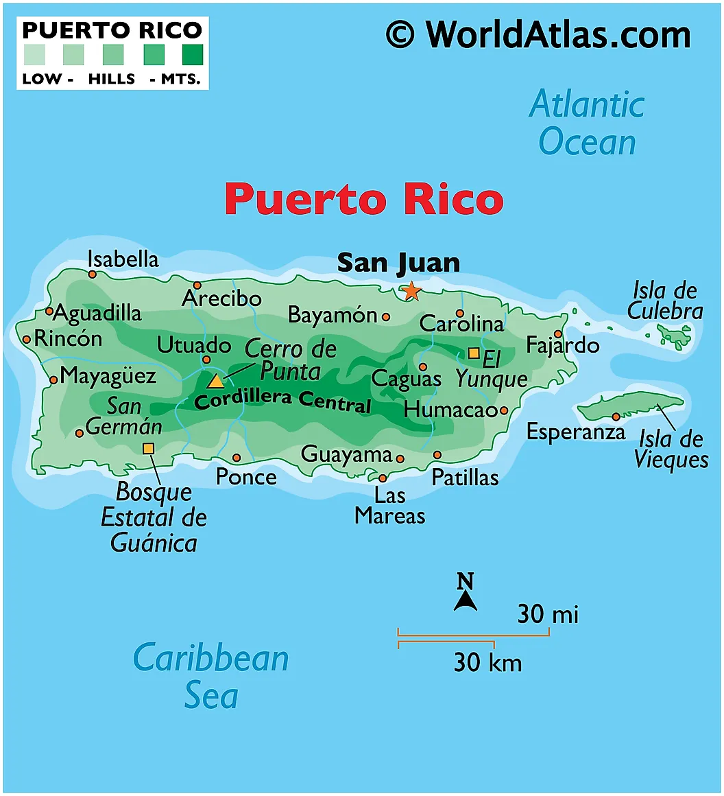
The 27-acre Campo del Morro (the open grass field stretching from the city walls to the fort's main entrance) is now one of the most popular public spaces in Puerto Rico, and is by far the island's most popular kite-flying spot. Weekend crowds of families, vendors, and visitors swell on windy days throughout the December-to-April trade-wind season. The fort itself is open to visitors for a modest National Park Service admission fee, and the same ticket covers the larger Castillo San Cristóbal on the eastern side of Old San Juan (technically the largest Spanish fortification ever built in the Americas). The grounds are also home to a vocal population of green iguanas (descendants of escaped pets, now classed as invasive but doing very well for themselves) and feral cats, both of which feature prominently in tourist photographs and have become unofficial mascots of the fort. The San Juan National Historic Site recorded over 1.6 million visitors in 2019 before pandemic-era closures, and visitor numbers had recovered to over 1.4 million by 2023.
Why El Morro Endures
Castillo San Felipe del Morro is one of the few Spanish colonial fortresses in the Americas that has stayed in continuous use across five centuries, transitioning from Spanish military post to American military post to National Park Service site without any long period of abandonment. The 248-year construction span (1539 to 1787) is itself a record among Spanish New World fortifications, and the 303-year run with no successful naval assault is a near-unique achievement among coastal forts globally. The fortress has become the visual shorthand for Puerto Rico in much the same way the Eiffel Tower stands in for Paris or the Sydney Opera House for Sydney, appearing on license plates, currency designs, and tourism materials for over a century. The kite-flying tradition on Campo del Morro now connects the working-fort era and the open-park era in a way the fort's original builders could not have anticipated when they were laying the first courses of sandstone in 1539.