Geography Of The Caribbean
The Caribbean Sea is the Atlantic Ocean’s second-largest marginal sea, after the Sargasso Sea, covering about 2.7 million square kilometers. Its deepest point is the Puerto Rico Trench, at 7,686 meters. The name “Caribbean” is derived from “Caribs,” a Native American tribe of the Lesser Antilles. The sea largely occupies the Caribbean Plate, with the island arcs separating it from the rest of the ocean. The Caribbean Sea is home to numerous coral reefs, including the Mesoamerican Barrier Reef, one of the world’s largest barrier reefs.
Location

The Caribbean Sea is located in the Western Hemisphere, between Central and North America. It is separated from the Pacific Ocean by Mexico and Central America on the west and bounded by the Greater Antilles to the north, the Lesser Antilles to the east, and south by South America. It is linked to the Gulf of Mexico to the north by the Yucatan Channel.
Climate

The Caribbean Sea is a tropical sea whose climate is generally tropical, characterized by great local variations. The sea’s climate is influenced by the tropical ocean currents, mountain elevation, and trade winds. The North Equatorial current, entering the Caribbean Sea from the tropical Atlantic, is a major influence on the region's climate.
Rainfall varies with water current and elevation, ranging from less than 12 inches per year on the Bonaire Island, off Venezuela’s coast, to 350 inches annually in the regions around Dominica. The trade winds blow across the region consistently at a velocity of 10-20 mph, creating semi-arid and rainforest climates in the area. The lowland areas between Belize and Costa Rica experience tropical rainforest climates, while Cuba, Yucatan Peninsula, and Venezuela experience dry tropical savanna climates. Arid climate is common around the islands of Curacao and Aruba.
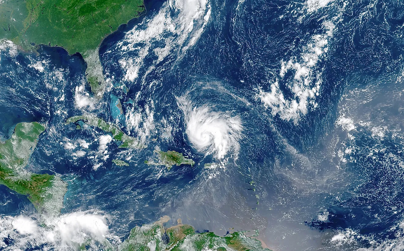
Tropical storms, attaining hurricane velocity of over 75 mph, are seasonally infrequent in the northern Caribbean but rare in the far south. The cyclones often develop on Africa’s West Coast and travel across the Atlantic Ocean. The hurricane season lasts between June and November, peaking in August and September. Therefore, the best time to visit the Caribbean is between December and April, when the weather is generally cooler, less humid, and drier.
Island Groups
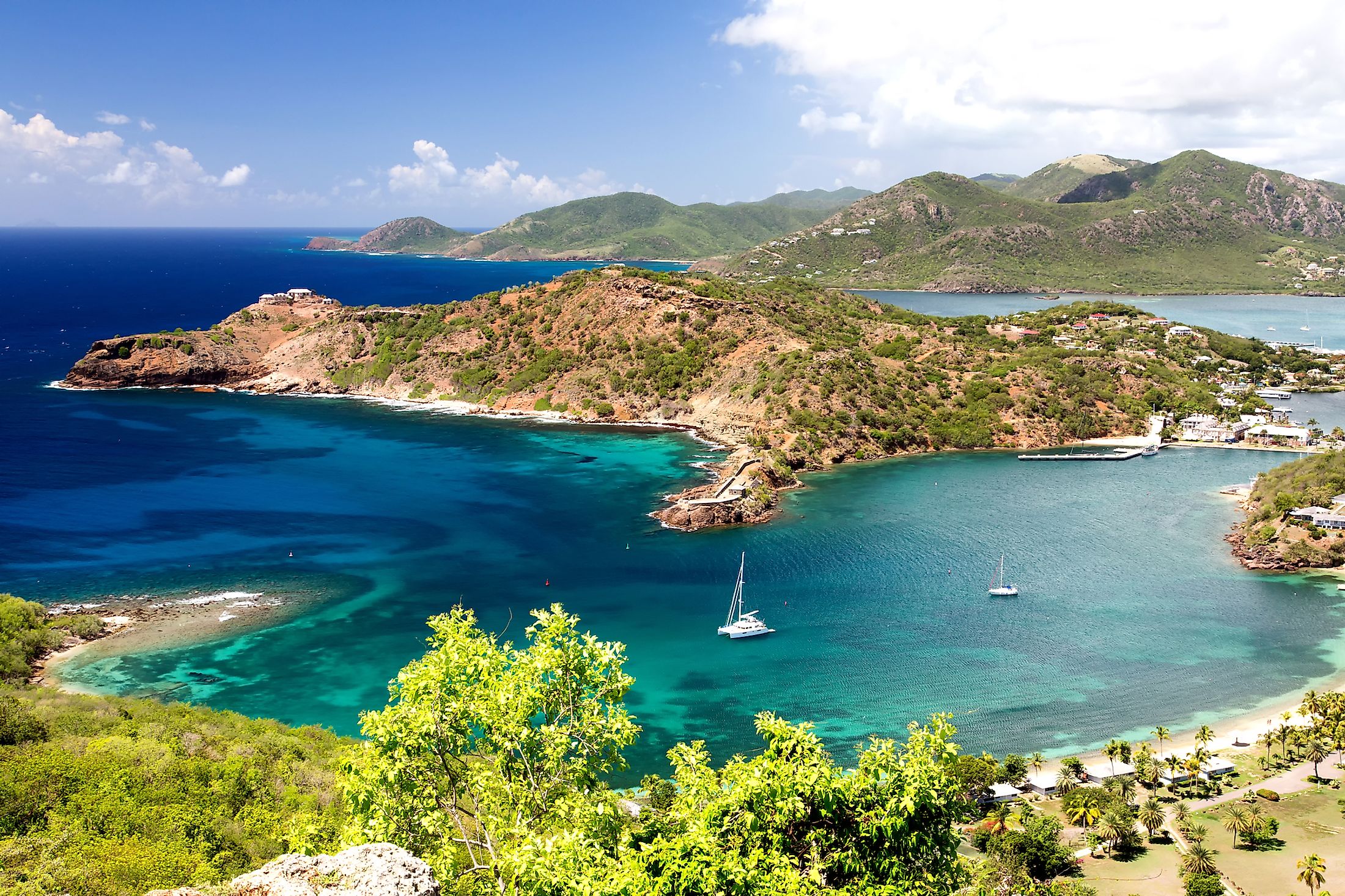
The Caribbean region has about 7,000 islands, including sovereign countries and territories. These islands are divided into three groups. The Greater Antilles is an island group on the Caribbean Sea’s north coast, comprising four island states and two overseas territories. The islands in this region include Hispaniola, Cuba, Jamaica, Cayman Island, and Puerto Rico. Hispaniola Island is shared by the Dominican Republic and Haiti, while the UK and the US possess Cayman Island and Puerto Rico. Cuba is the largest of the Caribbean islands, spanning 110,860 square kilometers. The Hispaniola Island lies between Cuba to the west and Puerto Rico to the east. Jamaica is located to the Hispaniola’s southwest, while the Cayman Islands are on Jamaica’s west.

The Lesser Antilles is an island group forming the Caribbean Sea’s eastern coast and located between the Greater Antilles and South America. The Lesser Antilles islands are divided into three main groups. The Leeward Islands comprises islands on the north, including the US Virgin Islands, the British Virgin Islands, Anguilla, Antigua and Barbuda, Guadeloupe, Saint Martins, Saint Barthelemy, Saint Kitts and Nevis, and Montserrat. The second Lesser Antilles are the Windward Islands, comprising Dominica, Saint Lucia, Martinique, Saint Vincent and Grenadines, Barbados, Grenada, and Trinidad and Tobago. The Leeward Antilles are islands off Venezuela’s coast, made up of the three Dutch ABC islands (Aruba. Bonaire, and Curacao). Trinidad and Tobago is the largest of the Lesser Antilles.
The third island group in the Caribbean Sea is the Bahamas (Lucayan) Archipelago. It comprises the island of Bahamas and Turks and Caicos Islands (British Overseas Territory). The two islands cover a total area of 5,524 square miles. The Greater Antilles, Lesser Antilles, and the Lucayan Archipelago form the West Indies region.
Relief
The Caribbean Sea is subdivided into five basins, separated by rises and ridges: Colombia, Cayman, Yucatan, Grenada, and Venezuela basins. The Yucatan Basin is the sea’s northernmost basin, with the Yucatan Channel separating it from the Gulf of Mexico. The Yucatan Channel runs between the Yucatan Peninsula on the west and Cuba on the east and has a sill depth of 5,250 feet. The Yucatan Basin is partially separated from the Cayman Basin by the Cayman Ridge, which rises above to form the Cayman Islands. On the other hand, Cayman Basin is separated from the Colombian Basin by the Nicaraguan Rise, which has a sill depth of approximately 4,000 feet. Finally, Beata Ridge separates the Colombian Basin from the Venezuelan Basin, while the Aves Ridge separates the Grenada Basin from the Venezuelan Basin.

Although most Caribbean islands are relatively flat, some are rugged and dotted with mountain ranges. The Caribbean’s highest mountain range is the Cordillera Central, which runs through the Dominican Republic (Hispaniola island). Pico Duarte, the Caribbean Region’s highest peak, with an elevation of 10,164 feet, forms part of the mountain range. The Cordillera Central extends into northern Haiti as Massif du Nord. The Blue Mountains is the longest mountain range in Jamaica. It hosts the country’s highest peak, the Blue Mountain Peak, which rises 2,256 meters above sea level. Other mountain ranges in the Caribbean are Dry Harbor and the John Crow Mountains.
10 Tallest Peaks In The Caribbean
| Rank | Mountain Peak | Country | Island | Elevation |
|---|---|---|---|---|
|
1 |
Pico Duarte |
Dominican Republic |
Island of Hispaniola |
3,098 m (10,164 ft) |
|
2 |
Loma Alto de la Bandera |
Dominican Republic |
Island of Hispaniola |
2,842 m (9,324 ft) |
|
3 |
Pic la Selle |
Haiti |
Island of Hispaniola |
2,674 m (8,773 ft) |
|
4 |
Pic Macaya |
Haiti |
Island of Hispaniola |
2,347 m (7,700 ft) |
|
5 |
Loma Gajo en Medio |
Dominican Republic |
Island of Hispaniola |
2,279 m (7,477 ft) |
|
6 |
Blue Mountain Peak |
Jamaica |
Island of Jamaica |
2,256 m (7,402 ft) |
|
7 |
Pico Turquino |
Cuba |
Island of Cuba |
1,974 m (6,476 ft) |
|
8 |
La Grande Soufrière |
Guadeloupe |
île de Basse-Terre |
1,467 m (4,813 ft) |
|
9 |
Morne Diablotins |
Dominica |
Island of Dominica |
1,447 m (4,747 ft) |
|
10 |
Montagne Pelée |
Martinique |
Island of Martinique |
1,395 m (4,577 ft) |

The Caribbean region is drained by numerous rivers, with the majority emptying into the sea or the Atlantic Ocean. The Magdalene River is the sea’s longest river inlet and Colombia’s principal river, flowing for about 949 miles from the Andes into the Caribbean Sea. Other major rivers draining into the Caribbean Sea are Motagua, Coco, San Juan, Chagres, and Altrato. Some of the Caribbean lakes include Lake Enriquillo (region’s largest lake), Lago de Oviedo, Laguna de Leche, Grand Etang Lake, Lake Miragoae, and Etang Saumatre.
Biodiversity

The Caribbean region has a high biodiversity level, with numerous endemic species. The region is mainly dominated by tropical vegetation and has over 13,000 plant species, of which 6.500 are endemic. Some of these endemic species are guaiac wood, Bayahibe rose, and ceiba. Other plant species in the region are mahogany and coconut palms. The shallow waters contain mainly seagrasses, such as turtle grass and shoal grass.

There are approximately 1,000 fish species in the Caribbean Sea, including four shark species, flying fish, angelfish, giant manta ray, parrotfish, Moray eel, and the Atlantic Goliath groupers. There are over 90 mammals, including whales, dolphins, and seals, as well as over 500 reptiles, of which 94% are endemic. The American crocodile, blue Iguana, Green Iguana, mona ground Iguana, and rock Iguana are some of the endemic reptiles in the Caribbean region.
Threats From Climate Change
Climate change is a major concern, especially for the islands in the Caribbean region. One of the major risks associated with climate change is the rise in sea level, which may reduce the size of some islands or cause them to completely disappear under the water surface. The sizes of Trinidad and Tobago and the Bahamas are expected to reduce by up to 80%. Strong hurricanes are also expected to become more frequent and lead to significant losses, including loss of lives. Other expected environmental changes are prolonged dry seasons and shorter wet seasons, as well as temperature rise.
Caribbean Islands By Size
| Rank | Island | Area (km2) | Country or Countries |
|---|---|---|---|
|
1 |
Cuba |
105,806 |
Cuba United States (Guantanamo Bay Naval Base) |
|
2 |
Hispaniola |
76,479 |
Haiti and Dominican Republic |
|
3 |
Jamaica |
11,188 |
Jamaica |
|
4 |
Puerto Rico |
8,896 |
Puerto Rico |
|
5 |
Trinidad |
4,827 |
Trinidad and Tobago |
|
6 |
North Andros Island |
3,439 |
Bahamas |
|
7 |
Isla de la Juventud |
2,237 |
Cuba |
|
8 |
Great Inagua Island |
1,543 |
Bahamas |
|
9 |
South Andros Island |
1,447 |
Bahamas |
|
10 |
Grand Bahama Island |
1,373 |
Bahamas |
|
11 |
Great Abaco Island |
1,144 |
Bahamas |
|
12 |
Martinique |
1,128 |
Martinique |
|
13 |
Isla Margarita |
1,020 |
Venezuela |
|
14 |
Basse-Terre |
848 |
Guadeloupe |
|
15 |
Cayo Romano |
777 |
Cuba |
|
16 |
Dominica |
750 |
Dominica |
|
17 |
Gonâve |
743 |
Haiti |
|
18 |
Cozumel |
647 |
Mexico |
|
19 |
Saint Lucia |
616 |
Saint Lucia |
|
20 |
Grande-Terre |
587 |
Guadeloupe |
|
21 |
Little Abaco Island |
559 |
Bahamas |
|
22 |
Eleuthera |
518 |
Bahamas |
|
23 |
Acklins Island |
497 |
Bahamas |
|
24 |
Long Island |
448 |
Bahamas |
|
25 |
Curaçao |
444 |
Curaçao |
|
26 |
Barbados |
431 |
Barbados |
|
27 |
Cat Island |
389 |
Bahamas |
|
28 |
Cayo Coco |
370 |
Cuba |
|
29 |
Saint Vincent |
345 |
Saint Vincent and the Grenadines |
|
30 |
Cayo Sabinal |
335 |
Cuba |
|
31 |
Grenada |
310 |
Grenada |
|
32 |
Tobago |
300 |
Trinidad and Tobago |
|
33 |
Bonaire |
294 |
Caribbean Netherlands |
|
34 |
Mayaguana |
280 |
Bahamas |
|
35 |
Antigua |
279 |
Antigua and Barbuda |
|
36 |
Saint Croix |
214 |
United States Virgin Islands |
|
37 |
New Providence |
207 |
Bahamas |
|
38 |
Grand Cayman |
196 |
Cayman Islands |
|
39 |
Aruba |
180 |
Aruba |
|
40 |
Tortuga |
178 |
Haiti |
|
41 |
Saint Kitts |
168 |
Saint Kitts and Nevis |
|
42 |
San Salvador Island |
163 |
Bahamas |
|
43 |
Barbuda |
161 |
Antigua and Barbuda |
|
44 |
Marie Galante |
158 |
Guadeloupe |
|
45 |
Great Exuma |
158 |
Bahamas |
|
46 |
La Tortuga Island |
156.6 |
Venezuela |
|
47 |
Crooked Island |
148 |
Bahamas |
|
48 |
Middle Caicos |
144.2 |
Turks and Caicos Islands |
|
49 |
Vieques |
135 |
Puerto Rico |
|
50 |
Little Inagua |
127 |
Bahamas |
|
51 |
Roatan |
125 |
Honduras |
|
52 |
North Caicos |
116.4 |
Turks and Caicos Islands |
|
53 |
Saona Island |
110 |
Dominican Republic |
|
54 |
Cayo Guajaba |
107 |
Cuba |
|
55 |
Montserrat |
102 |
Montserrat |
|
56 |
Cayo Fragoso |
101 |
Cuba |
|
57 |
Providenciales |
98 |
Turks and Caicos Islands |
|
58 |
Nevis |
93 |
Saint Kitts and Nevis |
|
59 |
Anguilla |
91 |
Anguilla |
|
60 |
East Caicos |
90.6 |
Turks and Caicos Islands |
|
61 |
Saint Martin |
87 |
Saint Martin and Sint Maarten |
|
62 |
Saint Thomas |
80.91 |
United States Virgin Islands |
|
63 |
Rum Cay |
78 |
Bahamas |
|
64 |
Ambergris Caye |
65 |
Belize |
|
65 |
Blanquilla Island |
64 |
Venezuela |
|
66 |
Colón Island |
61 |
Panama |
|
67 |
Isla Mona |
57 |
Puerto Rico |
|
68 |
Coche Island |
55 |
Venezuela |
|
69 |
Tortola |
55.7 |
British Virgin Islands |
|
70 |
Guanaja |
55 |
Honduras |
|
71 |
Popa Island |
53 |
Panama |
|
72 |
Bastimentos Island |
52 |
Panama |
|
73 |
Île à Vache |
52 |
Haiti |
|
74 |
Saint John |
51 |
United States Virgin Islands |
|
75 |
Útila |
49 |
Honduras |
|
76 |
Grande Cayemite |
45 |
Haiti |
|
77 |
Samana Cay |
45 |
Bahamas |
|
78 |
Cayo Saetia |
42 |
Cuba |
|
79 |
La Orchila |
40 |
Venezuela |
|
80 |
Anegada |
38 |
British Virgin Islands |
|
81 |
Cayo Largo del Sur |
37.5 |
Cuba |
|
82 |
Cristóbal Island |
37 |
Panama |
|
83 |
Cayman Brac |
36 |
Cayman Islands |
|
84 |
Carriacou |
34 |
Grenada |
|
85 |
Great Harbour Cay |
32 |
Bahamas |
|
86 |
Culebra |
30.1 |
Puerto Rico |
|
87 |
West Caicos |
28 |
Turks and Caicos Islands |
|
88 |
Beata Island |
27 |
Dominican Republic |
|
89 |
San Andrés |
26 |
Colombia |
|
90 |
Little Cayman |
26 |
Cayman Islands |
|
91 |
Cayo Cruz |
26 |
Cuba |
|
92 |
Big Pine Key |
25.8 |
United States |
|
93 |
Cubagua |
24 |
Venezuela |
|
94 |
Ragged Island |
23 |
Bahamas |
|
95 |
South Caicos |
21.2 |
Turks and Caicos Islands |
|
96 |
Saint Barthélemy |
21 |
Saint Barthélemy |
|
97 |
Sint Eustatius |
21 |
Caribbean Netherlands |
|
98 |
Virgin Gorda |
21 |
British Virgin Islands |
|
99 |
Long Cay |
21 |
Bahamas |
|
100 |
La Désirade |
20.64 |
Guadeloupe |
|
101 |
Tierra Bomba Island |
19.8 |
Colombia |
|
102 |
Bequia |
18.1 |
Saint Vincent and the Grenadines |
|
103 |
Grand Turk Island |
17.39 |
Turks and Caicos Islands |
|
104 |
Providencia |
17 |
Colombia |
|
105 |
Cayo Agua Island |
16 |
Panama |
|
106 |
Cayo Grande |
15.1 |
Venezuela |
|
107 |
Key West |
13.65 |
United States |
|
108 |
Cayo Guillermo |
13 |
Cuba |
|
109 |
Saba |
13 |
Caribbean Netherlands |
|
110 |
Canouan |
13 |
Saint Vincent and the Grenadines |
|
111 |
Big Corn Island |
10 |
Nicaragua |
|
112 |
Little San Salvador Island |
9.7 |
Bahamas |
|
113 |
Catalina Island |
9.6 |
Dominican Republic |
|
114 |
Terre-de-Bas |
9 |
Guadeloupe |
|
115 |
Conception Island |
8.5 |
Bahamas |
|
116 |
Ronde Island |
8.1 |
Grenada |
|
117 |
Jost Van Dyke |
8 |
British Virgin Islands |
|
118 |
Union Island |
8 |
Saint Vincent and the Grenadines |
|
119 |
Solarte Island |
8 |
Panama |
|
120 |
Isleta de San Juan |
7.8 |
Puerto Rico |
|
121 |
Salt Cay |
6.74 |
Turks and Caicos Islands |
|
122 |
Klein Bonaire |
6 |
Caribbean Netherlands |
|
123 |
Mustique |
5.7 |
Saint Vincent and the Grenadines |
|
124 |
Navassa Island |
5.2 |
United States (Claimed by Haiti) |
|
125 |
Terre-de-Haut |
5.2 |
Guadeloupe |
|
126 |
Isla Mujeres |
5.2 |
Mexico |