East African Rift
The East African Rift (EAR) is an extensive, intra-continental lowland region that is being slowly split by tectonic activity. As the name posits, it can be traced across the Eastern portion of the African continent, running in a generally North-South direction but with many meandering deviations. Because it is not a singular entity but rather a series of rifts formed by fracturing plates, it is more accurate to refer to this geological phenomenon as the East African Rift System (EARS). Competing theories exist as to exactly how the rifting that is slowly dividing the Horn of Africa from the rest of the continent is occurring. But what was made abundantly clear when a 50-foot-wide, miles-long crack opened in Southwestern Kenya is that the planet's incorrigible forces are working steadily to reshape the topography of East Africa.
Geography/Geology Of The East African Rift System

The budding Somali Plate has begun to fracture away from the older and larger Nubian Plate, or African Plate, as it is also known, carrying the Horn of Africa away from the mainland (at an estimated rate of 0.24 - 0.28 inches per year) in the process. Such splintering in this section of the Earth's lithosphere has formed a network of loosely connected rifts and rift-like grabens (German for "ditch"), known collectively as the East African Rift System. EARS, in conjunction with the Red Sea Rift and Jordan Rift Valley, sometimes referred to under the banner of "Great Rift Valley," runs for approximately 4,000 miles, with an average width of 30 to 40 miles.
The most Northerly portion of the roughly 1,864-mile-long East African Rift begins at the Red Sea/Gulf of Aden and continues all the way down to Central Mozambique and Northern Zimbabwe. There are also three microplates within this system: the Victoria Microplate (to the North) and the Rovuma and Lwandle Microplates (to the South). The ebb and flow of these tectonic entities have defined two clear subregions of the EARS: the Eastern Branch (also referred to as the Gregory Rift) and Western Branch, with some sources also differentiating a Southeastern Branch – all of which are composed of smaller rifts.
The Northern terminus of the East African Rift's Eastern Branch begins in the Afar region, near the meeting point of Northern Ethiopia, Southeastern Eritrea, and Western Djibouti, and about where the Red Sea and Gulf of Aden (an offshoot of the Arabian Sea) join. This is also where the Nubian, Somali, and Arabian Plates meet (but alas, are currently tearing apart): a site known as the Afar Triple Junction. From here, the oldest and most defined rift throughout the entire system, the Ethiopian Rift, kicks things off. The Eastern Branch then continues on a Southwesterly course through Central Ethiopia before roughly bisecting Kenya from North to South, taking a path a little West of the capital city of Nairobi and ending near Mount Kilimanjaro (i.e., Africa's highest peak). The Southeastern branch follows the Southeast Coast of Africa down into the Mozambique Channel, with some rifts occurring just offshore, on the floor of the Indian Ocean.

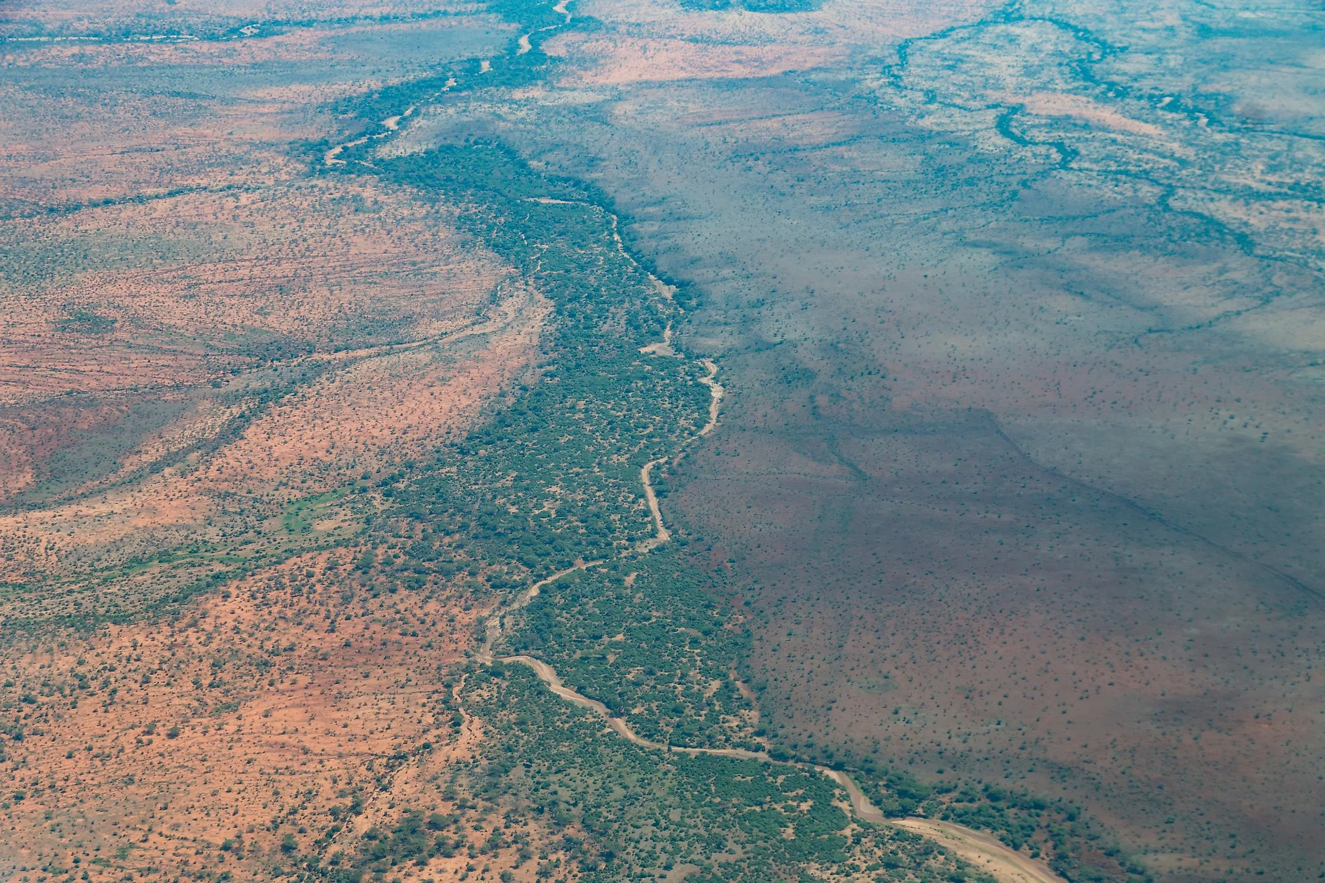
The Western branch (also known as the Albertine Rift) of the East African Rift System carves out a semi-circular path (that bulges West) through the Northern portion of the African Great Lakes region (also referred to as the Rift Valley lakes) before straightening out on its Southward journey to the East Coast of Central Mozambique, through the Southern section of the Great Lakes region. Whereas the Eastern branch is generally arid, the Western branch is exceptionally diverse – with highland forests, snow-capped peaks and savannas to complement the many lakes and wetlands.
The EARS experiences significant volcanic and seismic activity. Lava routinely erupts from the various fissures across its extent, and major individual volcanoes long-ago thrust onto the scene, including the likes of the 19,341-foot Mount Kilimanjaro, Mount Kenya, and Mount Nyiragongo. EARS is also the largest seismically active rift system on the planet. Most earthquakes hit around the Afar Depression/Afar Triple Junction, near the Northern terminus of the Rift Valley.
What Caused the East African Rift System?

Rifts, or rift valleys, are formed when the massive, rocky slabs of the lithosphere (i.e., the Earth's crust and upper mantle), known as tectonic plates, rupture or "rift." This differs from the formation of river and glacial valleys, which are carved out by the sometimes steady, sometimes violent forces of erosion. In the case of the East African Rift System, it is the deviation of the relatively new Somali Plate from the original, continent-dominating Nubian Plate that has created the long and narrow, North-South continental rifting. As the plates stretch horizontally, they become thinner and fracture into a plethora of rifts, great and small, throughout the EARS. This process has been unfolding since the beginning of the Miocene epoch, some 22 - 25 million years ago. While the basic tenets of plate tectonics and volcanism/magmatism are on display in East Africa, the precise geological mechanics underlying some of the evolving rift formations are a subject of ongoing debate amongst researchers.
EARS In The News
In March 2018, a sizable crack in the Earth's crust emerged in Southwestern Kenya's Suswa area. The 50-foot-wide, multi-mile-long fissure swallowed part of the Nairobi-Narok highway and forced the evacuation of some households. The shifting of tectonic plates is usually imperceptibly slow, but the combination of heavy rains and seismic activity left a scar in the terrain that clearly demonstrates the grand process that may one day (tens of millions of years from now) splice part of East Africa away from the mainland (similar to Madagascar).

On May 22, 2021, the 11,500-foot-high Mount Nyiragongo erupted in fierce fashion. In excess of 80,000 households, totaling over 400,000 people, had to be evacuated from the Democratic Republic of Congo city of Goma (and the surrounding area). Nyiragongo regularly shows signs of activity, as is evidenced by the pool of lava gurgling form within its crater. But on this day, lava shot upwards of three stories into the air, and spewed through fractures in the mountain slopes – quickly encroaching the outskirts of the 1.5-million-strong metropolis six miles away. Along with the large-scale devastation, dozens of people were killed and injured. This volcano in the middle of the East African Rift also erupted in 2022, killing approximately 250 people and leaving 120,000 people homeless, and in 1977, killing anywhere from 600 to 2000 people with its overwhelming lava flows.

The East African Rift System is not all doom and gloom. In fact, the unique environmental variations may have posed challenges and opportunities that greatly catalyzed the evolution of our hominid and australopithecine ancestors. A number of significant fossils have been unearthed in this part of the world that have helped hone our understanding of our biological lineage. Perhaps the most famous specimen of all is the ~3.2-million-year-old Australopithecus afarensis known as Lucy. Lucy was discovered by paleoanthropologist Donald Johanson and his team back in 1974 in Ethiopia's Awash Valley, which is part of the Afar Triangle/Depression.
The active continental rift zone known as the East African Rift, or more accurately, the East African Rift System, descends the better part of the eponymous region for thousands of miles. It is a complex, biodiverse, and capricious geographical area that gives researchers and all of us onlookers a real-time sense of the presence and obstinate power of tectonic plates. While Africa will remain a congruous continent for eons to come, EARS is always subject to sudden manifestations of distortions in the Earth's crust. And at the same time, it benefits from the generous ecosystems fostered by this collection of related rifts.


