Plate Tectonics
Our planet, the Earth, has four major layers: Crust, Mantle, Outer Core, and Inner Core. Lithosphere, the Earth's outermost rocky shell, is made up of the crust and the upper portion of the mantle. This lithosphere comprises many slow-moving tectonic plates that interact with each other to create new geological features and cause earthquakes and volcanic eruptions. Researchers have struggled over the years to understand how these tectonic plates move. This, in due course, gave rise to the universally accepted scientific theory of plate tectonics.
Development Of The Plate Tectonics Theory
In 1596, the Brabantian cartographer Abraham Ortelius put forth a 'speculation' which first mentioned the moving of the Earth's continents in respect to each other over geologic time. This concept of 'continental drift' was further developed independently by German geologist Alfred Wegener in 1912. The modern Plate Tectonics Theory, which developed during the initial half of the 20th century, is based on this 'continental drift' concept.

Plate Tectonics is a widely accepted theory of global dynamics that considers the lithosphere to be made up of a series of large tectonic plates which move or slide over each other. The theory further states that this movement of the tectonic plates is in response to 'convection' in the upper mantle. Moreover, the fluid-like asthenosphere lubricates the bottom of the tectonic plates, helping these plates to move around. The Tectonic Lithosphere comprises the lithospheric mantle that is, in turn, overlain by one or two types of crustal material, namely, the oceanic crust and continental crust. Formed at sea-floor spreading centers, the oceanic crust of mafic basaltic rocks is comparatively denser than the continental crust of low-density felsic granitic rocks.
Movement Of Tectonic Plates
The relative motion of the tectonic plates, which usually ranges from 2 to 10 cm yearly, determines the different types of plate boundaries at places where these plates meet. Mountain-building activity, volcanic eruptions, earthquakes, and ocean trenches formation occur along the tectonic plate boundaries. The three types of plate boundaries include convergent, divergent, and transform boundaries.

Convergent Boundary
Also referred to as a 'destructive boundary,' a convergent boundary is an area where two plates move towards one another. In this area, one of the plates slides beneath the other plate in a process known as subduction. Earthquakes, volcanic eruptions, and mountain-building activities are common along convergent boundaries.
Divergent Boundary
Also referred to as a constructive boundary, a divergent boundary indicates places where two tectonic plates move away from each other. Most active divergent boundaries are found between oceanic plates, where they exist as mid-oceanic ridges. The divergent boundaries within the continents produce rifts, eventually giving rise to rift valleys. Some of the well-known examples of such rifts include the Mid-Atlantic Ridge, East African Rift, etc.
Transform Boundary
Transform boundaries are formed when two tectonic plates slide past each other. As these faults involve neither any addition nor loss of lithosphere at the Earth's surface, they are also referred to as conservative plate boundaries. The transform faults are mostly found in the oceanic crust, although a few such faults can also be found on land. Some of the best examples of Transform Boundaries include the San Andreas Fault and the North Anatolian Fault.
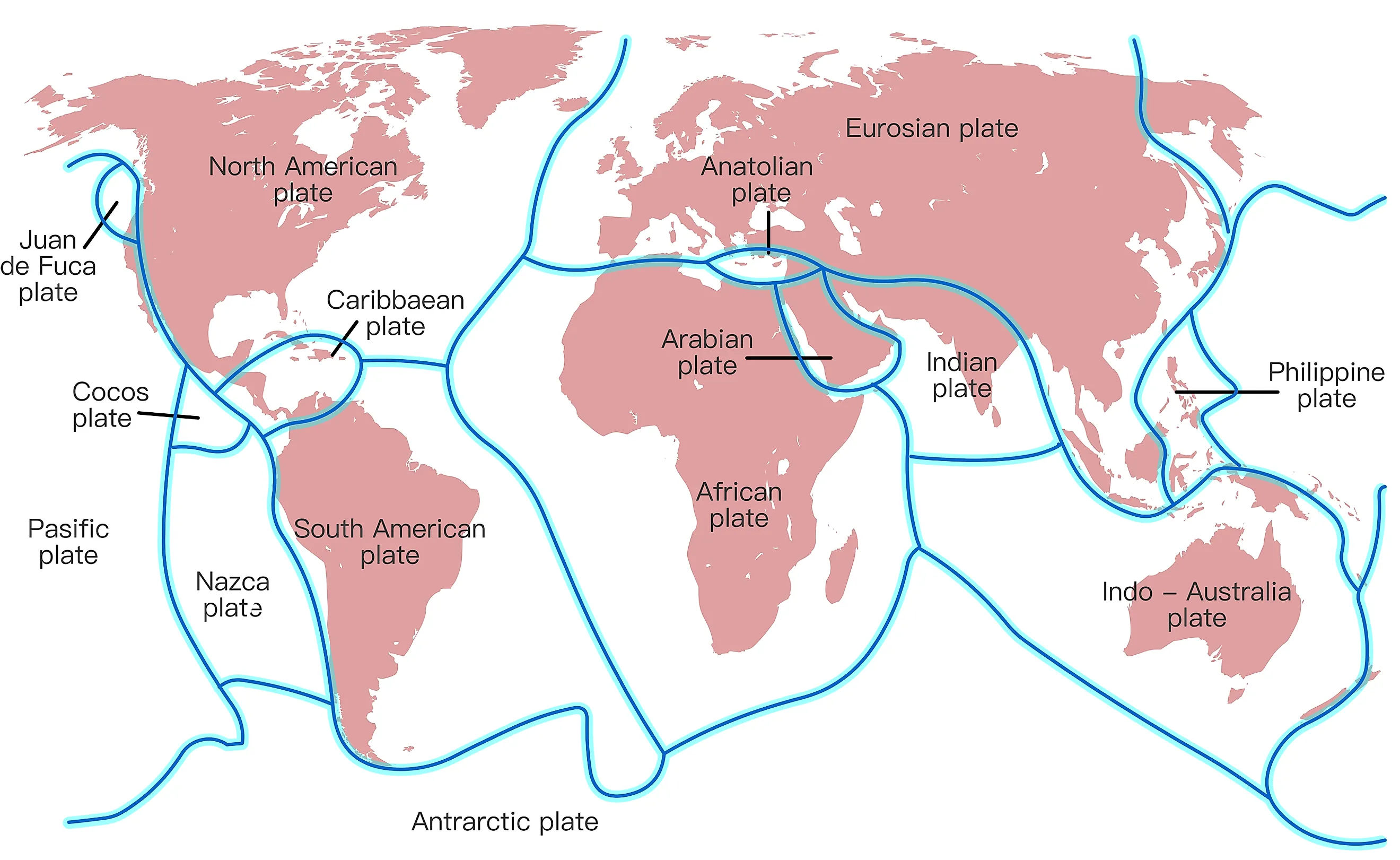
Types of Tectonic Plates
Geologists believe that, at present, three categories of tectonic plates are found on the Earth's surface. These include Major plates, Minor Plates, and Microplates.

Major Plates
Tectonic plates with an area greater than 20 million sq.km are considered Major (or primary) Plates. The seven major tectonic plates are Pacific Plate (103,300,000 sq. km), North American Plate (75,900,000 sq. km), Eurasian Plate (67,800,000 sq. km), African Plate (61,300,000 sq. km), Antarctic Plate (60,900,000 sq. km), Indo-Australian Plate (58,900,000 sq. km), and South American Plate (43,600,000 sq. km).
Minor Plates
Tectonic plates having an area of less than 20 million sq. km but more than 1 million sq. km are considered Minor (or secondary) Plates. These plates are not usually marked on major plate maps, as most do not occupy a significant land area. Some of the minor plates include Arabian Plate, Caribbean Plate, Cocos Plate, Indian Plate, Nazca Plate, New Hebrides Plate, Somali Plate, Philippine Sea Plate, etc.
Microplates
Tectonic plates having an area of less than 1 million sq. km are considered minor plates. Microplates on a plate map are generally grouped with the neighboring principal plate. Some examples of microplates include Adriatic Plate, Shetland Plate, Capricorn Plate, Tonga Plate, Panama Plate, Anatolian Plate, Timor Plate, Greenland Plate, Juan de Fuca Plate, Mariana Plate, Madagascar Plate, North Andes Plate, etc.
The plate tectonics theory clearly explains the movements of the Earth's surface, both in the past and present. These movements have led to the formation of various geological features, including towering mountains and deep ocean trenches, which in turn have shaped the Earth's diverse ecosystems. Additionally, the movement of tectonic plates has trapped atmospheric carbon dioxide within rocks, helping to stabilize the climate and making the Earth habitable. This theory also effectively explains the causes of earthquakes and identifies the areas where they are most likely to occur. In summary, plate tectonics is essential for understanding our planet.