What Is Orographic Precipitation?
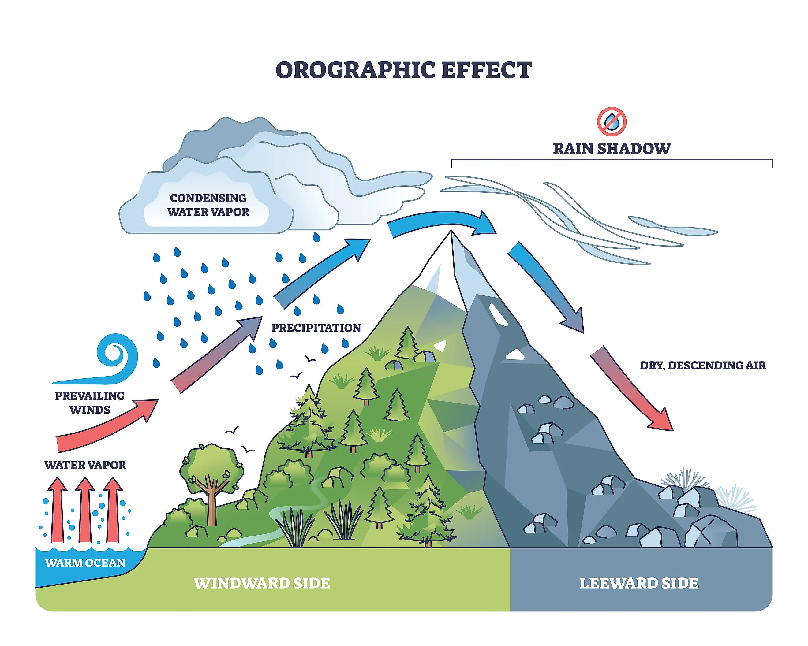
Orographic precipitation, whether snowfall or rainfall, is the result of what happens when a moving air mass meets rising terrain and is forced upward. As air encounters a hill or mountain range, it has no choice but to climb. The higher it goes, the more it expands and cools. Once the air cools to its dew point, the moisture it carries condenses into water droplets, forming clouds. If enough moisture accumulates, precipitation follows, falling as rain, snow, sleet, or hail depending on conditions. This process, known as the orographic effect, is one of the most important drivers of local weather patterns around the world, shaping everything from where forests grow to where deserts form.
How It Works

The mechanism behind orographic precipitation is mechanical. When a prevailing wind carries moist air toward a mountain or elevated landmass, the terrain acts as a physical barrier. The air is forced to rise along the windward slope, and as it gains altitude, atmospheric pressure drops. Lower pressure causes the air to expand and cool at a predictable rate, roughly 6.5 degrees Celsius per 1,000 meters (3.5 degrees Fahrenheit per 1,000 feet) in moist conditions. Once the air temperature falls to the dew point, water vapor begins condensing into droplets around tiny particles of dust, pollen, or salt suspended in the atmosphere. These droplets cluster into clouds, and when they grow heavy enough, precipitation falls, often heavily, along the upper slopes and summit of the terrain.
Rain Shadow

The precipitation typically falls on the windward side of the mountain, the side facing the incoming air. Once the air passes over the crest and begins descending on the opposite side, known as the leeward side, it compresses under increasing atmospheric pressure. This compression warms the air adiabatically, meaning the warming happens purely from the mechanical process of compression rather than from an external heat source. Warmer air holds more moisture, so instead of releasing precipitation, it absorbs whatever humidity remains. The result is a dry zone on the leeward side called a rain shadow. In regions with consistent prevailing winds, this pattern repeats predictably: the windward slopes stay lush and wet, while the leeward side can become strikingly arid, sometimes bordering on desert conditions even just a short distance from heavy rainfall on the other side of the range.
Effect on Meteorology

Terrain-driven precipitation is a major factor in how meteorologists forecast local weather. The shape, height, and orientation of a mountain range relative to prevailing winds all influence the type, intensity, and duration of precipitation in a given area. Research has shown that the width of the barrier, the steepness of the slope, and the speed of the incoming air all affect how much precipitation falls. Studies using computer simulations have demonstrated that narrower barriers and steeper slopes produce stronger updrafts, which increase vertical wind speeds and intensify precipitation on the windward side.
Notable Examples

Some of the most dramatic examples of orographic precipitation occur on oceanic islands, where moist maritime air meets volcanic peaks with little warning. In Hawaii, the contrast is staggering. Waikiki, on the leeward coast of Oahu, averages roughly 17 inches (430 mm) of rainfall per year, while Mount Wai'ale'ale on Kaua'i, one of the wettest spots on Earth, receives an average of around 373 inches (9,500 mm) annually. That is more than 20 times the rainfall just a few islands apart, all because of how the terrain intercepts moisture-laden trade winds. New Zealand shows a similar pattern. The Southern Alps run the length of the South Island, and the western slopes facing the Tasman Sea receive over 250 inches (6,300 mm) of rain per year in some areas, while towns on the eastern side, like Christchurch, average around 25 inches (640 mm).
The effect is not limited to the tropics. In northern England, the Pennine range creates a measurable rain shadow between its western and eastern sides. Manchester, sitting west of the Pennines in the path of Atlantic weather systems, averages around 33 inches (840 mm) of rainfall annually. Leeds, on the eastern side, receives roughly 26 inches (660 mm), a meaningful difference driven by the same windward-leeward dynamic that shapes rainfall in Hawaii and New Zealand.