11 Best Downtowns In Virginia
Virginia's small town downtowns reveal some of the state's most interesting features. Bristol shares its State Street with Tennessee, providing a unique opportunity to visitors to cross state boundaries while crossing the street without even reaching the sidewalk at its other end. Culpeper's railroad history remains alive in the railway line cutting through its center. Staunton's location on the undulating terrain of the Shenandoah Valley lends a layered appearance to its downtown. These eleven Virginia town centers each have distinct character and together they reflect the rich heritage and culture that define the state.
Staunton

Beverley Street does not follow a flat grid through Staunton. It climbs and drops with the Shenandoah Valley terrain, giving downtown a layered appearance as brick storefronts, church steeples, upper-story windows, and rooftops rise at different heights along the street.
The American Shakespeare Center is only a block off Beverley Street. Its Blackfriars Playhouse opened in 2001 as a recreation of Shakespeare’s indoor theater in London. Several blocks north, the Woodrow Wilson Presidential Library and Museum includes the Presbyterian manse where Wilson was born in 1856.
Much of the time downtown, however, can be spent on Beverley itself. Restaurants such as The Split Banana and Zynodoa occupy the same blocks as bookstores, galleries, and shops inside late-19th- and early-20th-century buildings. Staunton had an estimated 26,801 residents in 2025, yet its central commercial district remains concentrated enough to cover on foot.
Lexington

Main Street through Lexington looks like the commercial center of a community of fewer than 8,000 people until the northern end of downtown comes into view. Washington and Lee University and Virginia Military Institute sit almost side by side, putting two historic campuses within walking distance of the storefronts and restaurants farther south.
Washington and Lee’s Colonnade includes a row of 19th-century buildings facing the university lawn. Nearby, VMI’s Gothic Revival buildings give the neighboring campus a very different appearance. Main Street between the campuses and downtown passes restaurants, galleries, churches, and brick commercial buildings.
The Maury River lies just beyond the eastern side of town. From East Lexington, the Chessie Nature Trail follows seven miles of former Chesapeake and Ohio Railway bed and canal towpaths to Buena Vista. Parts of the route run beside the river, while other stretches cross farmland and wooded areas. Remnants of locks and dams from the old North River Navigation system survive along the way.
Abingdon

Across Main Street from each other in Abingdon are two buildings with very different histories. The Martha Washington Inn & Spa occupies a residence built in 1832 for General Francis Preston and his family. It later became a women’s college. Barter Theatre traces its history to 1933, when founder Robert Porterfield allowed patrons short on cash to exchange produce for admission.
Brick sidewalks continue along Main Street past the Washington County Courthouse and rows of historic commercial buildings. The Tavern has served meals from a building dating to 1779, while Rain Restaurant & Bar and Summers Roof and Cellar are also downtown.
Abingdon has another claim that most historic downtowns cannot make. The Virginia Creeper Trail reaches town on a former railroad corridor. The trail normally extends 34 miles between Abingdon and Whitetop Station near the North Carolina border, although Hurricane Helene damage has left sections beyond Damascus closed. As of 2026, the Abingdon-to-Damascus section remains open.
Culpeper

East Davis Street is only a few blocks long, which works in its favor. Restaurants, coffee shops, boutiques, and restored brick storefronts sit close together rather than being scattered across a large commercial district. Several buildings retain decorative cornices and upper-story windows from Culpeper’s development as a railroad town.
The railroad still cuts directly through the center. Culpeper’s former passenger depot stands near the intersection of Commerce and East Davis streets, close enough that arriving Amtrak passengers can step off the train within a block of downtown businesses.
For something away from the storefronts, Yowell Meadow Park sits south of the commercial blocks along Mountain Run. Paths cross open lawns and follow the creek through the park. Culpeper had an estimated 22,074 residents in 2025, making it considerably larger than Lexington or Farmville without approaching the scale of Virginia’s major cities.
Warrenton

Main Street rises toward the Fauquier County Courthouse in Warrenton, passing brick sidewalks, restaurants, offices, and historic buildings along the way. The courthouse has occupied this part of town in various forms for more than two centuries, helping establish the street pattern that remains in Old Town.
Just off Main Street, the former county jail looks very different from the commercial buildings nearby. The Fauquier History Museum at the Old Jail occupies two jail structures built in 1808 and 1823. The 1808 building originally contained four cells. After the larger jail opened next door, the older structure became living quarters for the jailer.
The blocks surrounding the courthouse are worth seeing on foot rather than from a car. Alexandria Pike, Culpeper Street, Ashby Street, and Main Street contain examples of Warrenton’s residential and commercial architecture, with the courthouse remaining an easy reference point near the center.
Winchester

Winchester took cars off two blocks of Loudoun Street in 1974. Today, the Loudoun Street Walking Mall runs through the center of Old Town with a brick walkway where the roadway once passed. Restaurant tables, benches, trees, shops, and historic facades now fill the pedestrian section.
Those two blocks account for only a fraction of Winchester’s older architecture. The surrounding historic district covers roughly 45 blocks, extending onto streets including Cork, Boscawen, Braddock, and Piccadilly.
The former Frederick County Courthouse stands directly on the walking mall and now houses the Old Court House Civil War Museum. A few blocks away, George Washington’s Office Museum preserves the small log and stone building Washington used while working in Winchester during the 1750s.
Fredericksburg

Caroline Street is a good place to understand Fredericksburg before heading toward its larger historic sites. Antique stores, restaurants, galleries, and shops occupy several blocks of older commercial buildings, while William Street crosses the district with another concentration of restaurants and businesses.
One block closer to the Rappahannock River is Sophia Street. Riverfront Park occupies nearly four acres at 701 Sophia Street, with a promenade, lawns, play areas, and open views toward the water. Continue northwest along the river and the landscape becomes greener around Old Mill Park, which has access to the Rappahannock River Heritage Trail as well as a canoe and kayak launch.
Fredericksburg’s colonial history is mixed directly into the downtown grid. Mary Washington House stands on Lewis Street, where George Washington’s mother lived during the final years of her life. The Rising Sun Tavern, built by Washington’s younger brother Charles around 1760, is several blocks away on Caroline Street.
Bristol

A person crossing State Street in downtown Bristol can walk from Virginia to Tennessee before reaching the opposite sidewalk. The state boundary follows the street through the commercial district, with brass markers identifying the line and the large Bristol sign hanging above it.
Country music gave the city another nationally recognized piece of history. In 1927, producer Ralph Peer held recording sessions in Bristol that included the Carter Family and Jimmie Rodgers. Those recordings became known as the Bristol Sessions. The Birthplace of Country Music Museum now tells that story from a building only a short distance from State Street.
Several remnants of Bristol’s early-20th-century growth survive nearby. The Bristol Train Station dates to 1902, while the Paramount Bristol opened in 1931. State Street itself remains the centerpiece, particularly where the Tennessee and Virginia halves of downtown face each other across the state line.
Farmville

Furniture stores are not normally historic attractions, but Green Front Furniture is difficult to separate from downtown Farmville’s architecture. The business occupies numerous buildings around Main and Mill streets, including former tobacco warehouses that survive from the period when Farmville was a regional tobacco market.
Longwood University borders downtown to the south. About a mile away, the former Robert Russa Moton High School houses the Robert Russa Moton Museum. In 1951, 16-year-old Barbara Johns led students there in a walkout protesting unequal school conditions. The resulting lawsuit became one of the five cases incorporated into the Supreme Court’s Brown v. Board of Education decision.
Cyclists and walkers can pick up High Bridge Trail directly in Farmville. The 32.2-mile state park follows a former railroad bed through town and east toward its namesake bridge. High Bridge measures more than 2,400 feet long and carries the trail 125 feet above the Appomattox River.
Smithfield

Main Street and Church Street hold much of Smithfield’s historic core near the Pagan River. Old houses and churches appear among restaurants and shops rather than being confined to a separate historic complex.
Smithfield’s architectural history reaches back well before the industry that made its ham famous. St. Luke’s Historic Church & Museum stands outside the central commercial blocks and dates to the 17th century, making it one of Virginia’s oldest surviving church buildings.
Closer to downtown, Windsor Castle Park covers 208 acres along Cypress Creek and the Pagan River. More than 3.8 miles of trails cross wooded areas, marshes, and creekside sections of the property. The park also contains the circa-1725 Windsor Castle manor house. A fishing pier sits along Cypress Creek, while paddlers can use the kayak and canoe launch for access to the Pagan River.
Front Royal

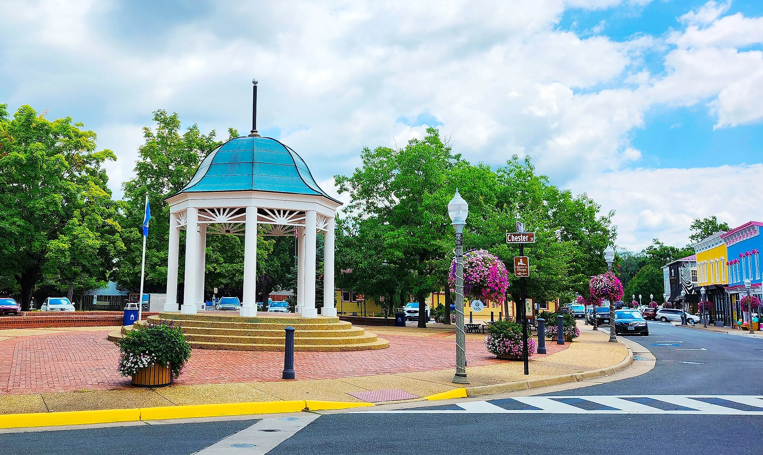
The mountains are visible from parts of Front Royal’s downtown, a reminder that Main Street sits only a short drive from the northern end of Skyline Drive. Shops and restaurants occupy the central blocks around Main and Chester streets, with the Warren County Courthouse nearby.
Front Royal also has two forks of the Shenandoah River nearby. The North Fork passes along the northern and western sides of the community, while the South Fork approaches from the south. The two join northeast of town to form the main stem of the Shenandoah River.
For drivers, Front Royal has another important geographic marker. The Front Royal Entrance Station is the northern entrance to Shenandoah National Park and mile 0 of Skyline Drive. From there, Skyline Drive runs south for 105 miles through the park to Rockfish Gap near Waynesboro. Dickey Ridge Visitor Center is at mile 4.6, making it one of the first major stops after entering the park from Front Royal.
Virginia's Downtowns Beyond The Big Cities
No single type of downtown dominates this list. Warrenton grew around a courthouse, while Culpeper and Farmville still show evidence of their railroad histories. College campuses shape the northern end of Lexington. In Bristol, geography put two states on opposite sides of the same street.
Several towns also have direct connections to the surrounding landscape. Farmville’s rail trail crosses the Appomattox River on High Bridge, Smithfield has 208 acres along Cypress Creek and the Pagan River at Windsor Castle Park, and Front Royal marks the northern end of Skyline Drive. In each case, the downtown still reveals something specific about why the community developed where it did.