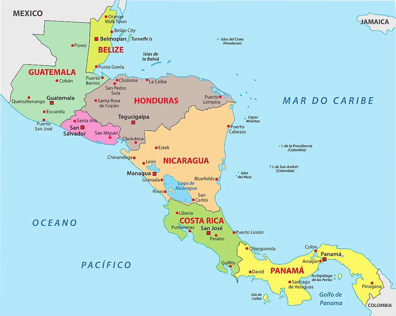
The 7 Countries Of Central America
The seven countries, Costa Rica, El Salvador, Guatemala, Honduras, Nicaragua, Panama, and Belize, of Central America make up a diverse region of modern cities, ancient cultural sites, and pristine wilderness areas. Central America is North America's southernmost region. It is an isthmus that connects Mexico in North America to Colombia in South America, separating the Pacific Ocean to the west from the Caribbean Sea to the east. It encompasses an area of 202,230 sq mi with a population estimated at 42,386,500 million inhabitants. Central America is only about 30 miles wide at its narrowest point, and no location on the isthmus is more than 125 miles away from the sea.

The area is characterized by lush tropical rainforests, mountain ranges, and coasts that offer access to the Caribbean Sea and the Pacific Ocean. Each country in Central America has a unique history and culture that differentiates it from the others. Consequently, Central America is home to an incredible variety of cultures, languages, and gastronomy, making it an ideal destination for visitors looking to explore the many different cultures this continent offers.
Countries Of Central America
Belize

Belize is a small Central American country located on the Caribbean coast. Mexico borders it to the north and Guatemala to the south and west. With an area of only 8,867 square miles, Belize has the second-lowest population density in Central America, with an estimated total population of 408,436.
Belize is renowned for its rich archaeological record, with evidence of human settlement dating back at least 3,000 years. The Maya civilization flourished in this region during the pre-Classic and Classic periods (300 BC - 900 AD) before being conquered by Spanish colonists in 1638. After gaining independence from the British crown in 1981, Belize began to develop its own economy and culture.
Geographically, Belize is divided into three distinct regions: the lowlands along the Caribbean Sea, hills and plateaus inland, and mountainous terrain near its borders with Mexico and Guatemala. Much of this terrain is covered by rainforest that supports vast biodiversity - jaguars, tapirs, and parrots are just a few of the animals found here.
The climate in Belize is tropical, with temperatures remaining reasonably steady year-round thanks to maritime trade winds from the east. The wet season usually occurs from June to October, with frequent showers throughout most of the day. Average temperatures range from 86°F on land to 79°F offshore.

Belizeans have diverse cultural roots stemming from enslaved Africans brought over during colonial times and Amerindian settlers who came before them - Mopan/Kekchi Mayas being particularly predominant. These different ethnic backgrounds have been blended over time, allowing unique local customs such as preparing traditional dishes like Hudut (green plantains served in coconut milk) or enjoying Garifuna music played on drums called Primero (tenor) and Segunda (bass). Similar in design to African instruments, these drums are standard for dancing in folkloric dances like punto or hunguhungu. Belize also offers great eco-tourism opportunities due to its ample wildlife reserves and beautiful coral reefs that line much of its Caribbean coastline; snorkeling, exploring ancient ruins, and diving trips are trendy among visitors.
Costa Rica

Costa Rica is a small Central American country between Nicaragua and Panama, with the Caribbean Sea to the east and the Pacific Ocean to the west. With an area of 19,729 square miles, it is slightly larger than Belize but has a total population of 5,199,034.
Costa Rica has a long history stretching back thousands of years; evidence suggests that ancient Amerindians inhabited the region by at least 8,000 BCE. Spanish conquistadors discovered this land during the Colonial period (1523-1821) and established settlements in the capital city of San Jose. After gaining independence from Spain in 1821, Costa Rica went through civil unrest before becoming one of the most democratic countries in Latin America by 1948.
Geographically speaking, Costa Rica is primarily rugged mountain terrain with some lowlands on either side. The highest peak is Cerro Chirripó which stands at 12,536 feet above sea level near the Talamanca Mountains in the southeast part of the country. There are also numerous volcanoes throughout Costa Rica that offer dramatic landscapes for visitors to explore.

The climate throughout Costa Rica can vary greatly depending on location and height above sea level – temperatures range anywhere from 80°F (26°C) in northwest Guanacaste province to 58°F (14°C) near San Jose and higher altitudes. Rainfall is heaviest during October - December, when brief yet intense rain showers occur during afternoons and evenings.
Costa Rican culture remains heavily influenced by its past colonial Spanish roots. However, local customs also reflect contributions from different ethnicities, like the enslaved Africans, who captors brought over, and Jamaicans, who migrated during the late 19th century for work opportunities related to banana exports or gold mining activities. The music here can range from traditional folkloric dances such as Palo de Mayo or Cimarron to more contemporary reggae beats played in local bars and pubs along shores like Puerto Viejo de Talamanca in Limón province.
When it comes to tourism attractions; Costa Rica offers an array of natural wonders to behold, including cloud forests full of exotic wildlife like toucans and macaws found within tropical jungles; as well as breathtakingly beautiful beaches with warm water along both coasts that make it perfect for snorkeling or surfing lessons.
El Salvador

El Salvador is a small country in Central America, bordered by Guatemala to the west and Honduras to the east. It has an area of 8,124 square miles, making it the smallest country in Central America. El Salvador's current estimated population is 6,352,999.
El Salvador's history dates back thousands of years to when it was part of the Mayan Empire; archaeological evidence, including cave paintings, suggests that human settlement here began around 6000 BCE. It became part of the Aztec Empire before being conquered by Spanish colonists in 1524 and declared an independent nation in 1821 (although it took until 1841 to acquire sovereign powers).
Geographically, El Salvador is divided into four natural regions - Pacific lowlands, central highlands, eastern mountains, and San Miguel's coastline. The central highlands are primarily known for their lush vegetation, with numerous rivers and lakes dotting the landscape. At the same time, along the coast, one will find some beautiful sandy beaches where it is common to relax and enjoy the sun.
El Salvador's tropical climate has two distinct seasons - wet (May-October) and dry (November-April). Temperatures remain relatively constant throughout most parts of the year ranging from 80°F (27°C) on land to 77°F (25°C) offshore.

The culture here is predominantly based on its Spanish colonial roots with influences from enslaved Africans brought over during this period and the Amerindian tribes who lived here before them. This diverse background has resulted in a unique culture full of colorful festivals such as Semana Santa, folkloric dances like parranda, or mascaras de Callejon (a type of mask), and traditional dishes like pupusas (corn tortillas filled with cheese and beans).
El Salvador offers plenty of opportunities for eco-tourism thanks to its stunning landscapes and many nature reserves, which host diverse fauna such as toucans, pumas, and several species of sea turtles that use its coasts as nesting grounds.
Guatemala

Guatemala is a Central American country bordered by Mexico to the north and west, Belize and the Caribbean Sea to the east, and El Salvador and Honduras to the south. The small nation covers an area of over 42,042 square miles and has an estimated population of around 17,996,471. Guatemala has a long and fascinating history that dates back thousands of years. Originally home to the Mayan civilization, Spain colonized Guatemala in 1524 and gained independence in 1821.
Geographically, Guatemala is divided into three distinct regions - the lowlands along its Pacific coast (including much of its coastline), hills or highlands near its interior, and mountainous terrain near its borders with Mexico and Belize. Guatemala's landscape is breathtaking, with over eight active volcanoes spread across its volcanic mountain ranges. Given its vast range of elevations, this beautiful country also offers different climate zones, ranging from humid tropical conditions along coastal plains to temperate alpine climates on higher ground.

Thanks to centuries of intermingling cultures, Guatemalans have developed their unique version of Central America's culture with traditions from both indigenous native peoples such as Maya ethnicities as well as Spanish settlers who arrived during colonial times. Guatemalan cuisine consists of a variety of dishes based on local staples like maize/corn-based flatbreads such as tortillas served along with meats like turkey or pork as well as vegetables like potatoes or plantains - all cooked in traditional spices like cumin or chili peppers.
Apart from being an exciting place for travelers due to its cultural diversity, Guatemala also provides visitors with plenty of things to do outdoors; you can explore the Mayan ruins, which are scattered throughout the country, or marvel at stunning views atop one of its many mountain peaks. Of course, one must remember Lake Atitlan; surrounded by lush vegetation, it is one of the most beautiful lakes in the world.
Honduras

Honduras is a Central American nation located in the Caribbean Sea. It borders El Salvador, Nicaragua, Guatemala, and the Gulf of Honduras. The country has an area of 43,278 square miles with an estimated population of 10,530,493.
The first evidence of human settlement in what is now known as Honduras dates back to 10,000 BC when migrating Paleo-Indians reached this region. By 300 BCE, the nomadic hunter-gatherer tribes transitioned into more established indigenous cultures like Pech and Lenca. These cultures were heavily influenced by the Olmecs, who arrived from Mexico during the Classic period (200 - 900 CE). Following the collapse of this civilization by 1000 CE, Mayans from Guatemala adapted their culture to create highly advanced settlements that flourished until their eventual demise at the hands of Spanish conquistadors in 1538.
Honduras is composed chiefly of hilly terrain with narrow coastal plains on its Caribbean coast and more expansive plains along its Pacific lowlands. Plateaus are throughout much of the interior. This landscape is mainly covered by lush tropical rainforests which support many species such as jaguarundi, scarlet macaws, and spider monkeys, among others; these are all protected in numerous national parks throughout the country.

The climate in Honduras is tropical, with two distinct seasons - wet (from April to November) and dry (from December to March). Average temperatures vary significantly according to altitude ranging from 77°F (25°C) on sea level to 54°F (12°C) on mountaintops. In contrast, daytime temperatures tend to be quite warm nights usually cool down considerably in higher elevations.
Honduran culture has been dramatically shaped over centuries by an array of influences, including European colonizers, enslaved Africans brought over during colonial times, and Amerindian settlers who arrived here long before them - Lencas being particularly predominant; each group leaving their imprint on local customs which are still common in traditional crafts like woven baskets or unique dishes like baleadas made with flour tortillas filled with cheese, beans, and other fillings served throughout morning meals. Moreover, Soccer is one of Honduras' favorite pastimes; therefore, it's no surprise Honduras boasts impressive soccer stadiums, making it an excellent place for any sports fan looking for action. Today Hondurans have come together, creating an exciting mix of indigenous peoples united under one vibrant nation.
Nicaragua

Nicaragua is a Central American country located between Honduras and Costa Rica. It has a total land area of 50,336 square miles and a population of 7,009,283.
Nicaragua has deep historical roots, stretching back to the 3rd century when it was inhabited by Nahua Indians, later called Nicarao. In 1502 Christopher Columbus made his first voyage to the region on the way to Panama. He declared it "the fairest land ever seen" and claimed it for Spain. The Spaniards brought Christianity and European customs, which still influence Nicaraguan culture today.
Geographically, Nicaragua is divided into three distinct regions: the mountainous Pacific coastal range in the west, highland plateaus in its center, and low-lying flatlands towards the Caribbean Sea in its east. Its climate varies depending on elevation and ranges from tropical dry forests near sea level to cooler climates higher up in the mountains. Average temperatures typically range from 77°F (25°C) along the coast to 65°F (18°C) inland during summer months.

The culture of Nicaragua is unique, described by some as a harmonious blend of Spanish colonial heritage and African influences due to long-standing migration from nearby nations throughout Latino America, all contributing to an eclectic mix of music, dance, food, and art forms found around this country today. Like Belizeans, Nicaraguans also share similar folklore dancing styles such as marimba or traditional songs. Popular sports are baseball and soccer, but volleyball too is popular among young people who like to play it on beaches after school and work hours.
In addition, Nicaragua offers fantastic eco-tourism opportunities that are famous worldwide. With some of Central America's most biodiverse rainforest regions protected by national parks like Bosawás or Selva Negra, travelers can explore beautiful natural wonders while spotting bright birds or encountering unusual wildlife in their habitats. Last, the tropical climate makes any time of year suitable for outdoor activities making this region one great adventure spot worth visiting.
Panama

Panama is located in Central America and is part of the Isthmus of Panama, which connects North and South America. Colombia borders it to the southeast and Costa Rica to the northwest. With an area of 29,120 square miles, it has an estimated population of 4,445,393.
Humans have been inhabiting the region since 10,000-7,000 BCE, with agricultural and hunter-gatherer societies leaving their mark on many archaeological sites throughout the country. The earliest known indigenous people settled along the Pacific coast over 6,000 years ago and today are conceivably direct descendants of the Maya civilization in nearby Guatemala. Spanish conquistadors arrived in Panama in 1501, and subsequent colonial rule saw enslaved Africans being brought over to work on various trading activities, including gold mining, until gaining independence in 1903.
Regarding terrain, Panama is divided into four distinct regions: a central mountain range that runs east-west across the center; tropical rainforest towards the south; extensive wetland areas along both coasts; and a dry zone towards the northern border with Costa Rica. There are also numerous islands off its coastline - some more than 100 miles (160 km) away.

The climate in Panama ranges from subtropical/tropical wetlands near the Caribbean coastline to temperate near the Pacific coast due to increased elevation differences between ocean surfaces. Average temperatures remain reasonably steady year-round, with highs around 90°F (32°C) during the day dropping overnight to lows near 72°F (22°C). Rainfall decreases dramatically from the wetter Atlantic side to the drier Pacific side.
Panamanians share a diverse cultural heritage from indigenous communities such as Guna Yala, Ngobe Bugle, and Embera Choco, as well as those descended from Spanish colonists or enslaved Africans. The results of this melting pot are present in local festivals like Fiesta de la Santa Cruz, where Panamanians gather wearing traditional clothing composed of bright colors signifying different meanings associated with each hue. At the same time, food like ceviche (seafood mixed with citrus juice) or tamales made from corn husks filled with plantains are everywhere.
Meanwhile, artistic expressions such as Pollera dances (inspired by Afro-Caribbean rhythms) or Tamborito music originating from Panama City are apparent all over the streets. Finally, Panama offers a wealth of attractions for tourists looking for adventure. There's something here for everyone, whether exploring fascinating pre-Columbian ruins sprinkled across the country, deep sea fishing trips off Bocas del Toro Islands, or even going bird watching at La Amistad International Park near Costa Rica's border.
Central America is a fascinating region, with each country offering unique cultural and historical experiences. From ancient civilizations to modern cities, the seven countries of Central America are a must-see for travelers looking for a fantastic variety of people, cultures, and experiences. Whether exploring an archaeological site, strolling a colorful market, or rafting along a river, these seven countries of Central America promise an unparalleled adventure for any explorer visiting.
The 7 Countries Of Central America
| Country | Capital City | Area (mi2) | Population |
|---|---|---|---|
| Belize | Belmopan | 8,867 | 408,436 |
| Costa Rica | San Jose | 19,729 | 5,199,034 |
| El Salvador | San Salvador | 8,124 | 6,352,999 |
| Guatemala | Guatemala City | 42,042 | 17,996,471 |
| Honduras | Tegucigalpa | 43,278 | 10,530,493 |
| Nicaragua | Managua | 50,336 | 7,009,283 |
| Panama | Panama City | 29,120 | 4,445,393 |


