Southern African Countries
- Southern Africa is the smallest and least populous subregion of Africa.
- About 68 million people live in Southern Africa.
- South Africa is the largest and most populous country in Southern Africa. About 88% of all the people in Southern Africa live in South Africa.
- eSwatini, Lesotho, and Botswana are among the few countries in Africa in which one ethnic group forms a majority.
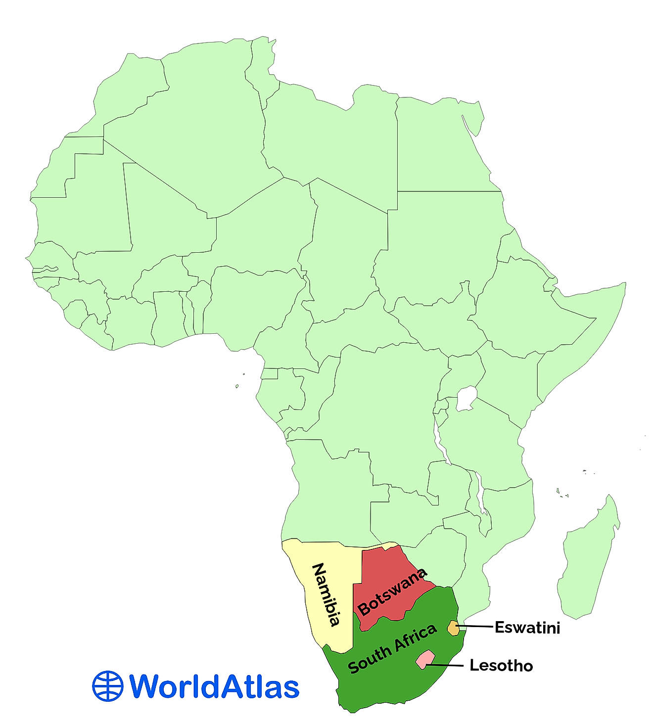
Southern Africa is a subregion of Africa, according to the United Nations Geoscheme. It is the smallest and least populous of all the African subregions, with a population of approximately 68 million and a land area of 2,650,670 km2. Southern Africa contains only five countries: South Africa, Namibia, Botswana, Lesotho, and eSwatini (formerly known as Swaziland). The subregion is bordered to the northwest by Middle Africa, to the northeast by East Africa, and to the south and west by the Atlantic Ocean. South Africa is the largest country in Southern Africa, while eSwatini is the smallest. Botswana, Lesotho, and eSwatini are landlocked countries.
Countries Of Southern Africa:
eSwatini

eSwatini used to be called Swaziland until the Swazi king decided to change the country’s name in 2018. The name “eSwatini” literally means “land of the Swazis.” Thus, it is the homeland of the Swazi people. eSwatini is bordered to the north, south, and west by South Africa, and to the east by the East African country of Mozambique.
The population of eSwatini is an estimated 1.17 million, making it the least populous country in Southern Africa. It is also the smallest country in the subregion, with a land area of 17,200 km2. The language of the Swazi is called siSwati. Both siSwati and English are official languages in the country. eSwatini’s largest city is called Manzini, which has a population of approximately 110,000. eSwatini is governed by its king, who rules as an absolute monarch. In fact, he is the only absolute monarch in all of Africa.
Lesotho

Lesotho is a landlocked country completely surrounded by South Africa. It has an estimated population of 2.15 million, and a total land area of 30,360 km2. Lesotho is the homeland of the Basotho people, who make up 99.7% of the population, making the country the most homogenous in Africa and one of the most homogenous in the world. The language of the Basotho is known as Sesotho. Both Sesotho and English are official languages in the country.
The largest city in Lesotho is the capital, Maseru, with a population of approximately 118,000. Lesotho is a constitutional monarchy. Its king has no political power but serves as a symbol of national unity. Economically, Lesotho is heavily dependent on South Africa. Many members of the country’s workforce work in South Africa’s mines. The country has one of the higher literacy rates in Africa, at 76%. Nevertheless, Lesotho is still a developing country. Its life expectancy is just 51 years for men and 57 years for women. Just under a third of the population lives in urban areas, and 40% of the population lives below the international poverty line of $1.25 USD per day.
Botswana

Botswana is a landlocked country east of Namibia and west of the East African country of Zimbabwe. Namibia’s Caprivi Strip also borders Botswana to the north. South Africa is its neighbor to the south. As its name implies, Botswana is the homeland of the Tswana people, who make up 79% of the country’s population. The total population of Botswana is an estimated 2.39 million people. The country’s total land area is 566,730 km2, of which 70% is part of the Kalahari Desert.
Unlike Lesotho and eSwatini, Botswana’s population is mostly urban. To be more precise, 72.8% of the country’s population lives in urban areas. Botswana is substantially more developed than most African countries. In fact, the country ranks the highest among sub-Saharan countries on the Human Development Index. Nevertheless, Botswana faces substantial challenges. It has been particularly hard-hit by the HIV/AIDS epidemic. Indeed, Botswana has the third-highest prevalence of HIV/AIDS in the world. About 25% of its population has the disease. On the bright side, Botswana is known as being one of the most stable countries in Africa. It has had a stable, democratic government since it gained independence in 1966.
Namibia

Namibia is located north of South Africa, south of the Middle African country of Angola, west of Botswana, and east of the Atlantic Ocean. It is named for the Namib Desert. The country has an estimated population of 2.58 million and a total land area of 823,290 km2. Namibia was formerly administered by South Africa. But in 1966, its people began rebelling against South African rule, until they finally achieved independence in 1990. Thus, Namibia is the youngest country in Southern Africa.
In terms of ethnicity, the ethnic group known as the Ovambo comprise about half of Namibia’s population. They live mostly in the northern part of the country, and in the country’s urban centers. Over half of the country’s population, 55.2%, lives in urban areas. Living standards in Namibia are higher compared to other African countries. For example, the overwhelming majority of Namibians, 91%, have access to safe drinking water. The country’s literacy rate is 81.9%. Nevertheless, Namibia is still a developing country, where 65% of its people lack sufficient sanitary facilities, which can often lead to illness.
South Africa

South Africa is the largest and most populous country in the Southern African subregion. It has a total land area of 1,213,090 km2 and a population of nearly 60 million. Thus, it contains more people than all the other countries of Southern Africa combined and is home to about 88% of the subregion’s population. South Africa is bordered to the north by Namibia, Botswana, and the East African countries of Zimbabwe and Mozambique. It surrounds the small country of Lesotho, and borders eSwatini on three sides in the east.
South Africa has several cities with populations in excess of 1 million people. The largest South African city is Cape Town, on the country’s southwest coast. It has a population of over 3.4 million and is known for being the point at which the Atlantic and Indian Oceans meet. Other large cities include Durban, Johannesburg, Soweto, and Pretoria. Two of these cities, Johannesburg and Pretoria, serve as national capitals, in addition to South Africa’s third capital, Bloemfontein, making South Africa the only country in the world with three capitals. All political power in the country formerly belonged to white South Africans in a system of racial segregation known as Apartheid. Through the efforts of leaders like Nelson Mandela, who ultimately became South Africa’s first black president, the Apartheid system was dismantled, and South Africa is now a multiracial democracy.
Southern African Countries
| Country | Population (2021) | Land Area (km2) |
|---|---|---|
| eSwatini | 1,170,663 | 17,200 |
| Lesotho | 2,157,103 | 30,360 |
| Botswana | 2,392,987 | 566,730 |
| Namibia | 2,581,017 | 823,290 |
| South Africa | 59,961,755 | 1,213,090 |


