Which Countries Border Denmark?
Denmark is a Nordic state which is situated in Northern Europe. The country is made up of the Danish Archipelago (numerous islands on the Baltic Sea) and the Cimbrian Peninsula.The Danish archipelago is composed of over 10,001 islands, and this does not include Greenland or Faroe Islands. Only seventy islands are inhabited in Denmark. Some of these islands were deserted a few years due to the economic reasons. The Cimbrian Peninsula forms part of Denmark and northern Germany. The cape is relatively flat with peat bogs, plains, heaths and open land to the west and mountainous terrain to the east.
Denmark is bordered by Schleswig-Holstein (a German state) to the south creating Denmark’s only land border. It is situated to the southwestern side of Sweden and south of Norway. Denmark borders the North Sea and Baltic Sea along its 5,440 miles long coastline, and without their off-shore islands, its shoreline is about 1,057 miles long. The exact size of the country cannot be determined since the ocean continually adds and erodes materials from their coastline, but it is estimated to occupy an area of about 16,639 sq miles.
What Nations Surround Denmark?
1) Germany
Denmark shares its only land border with one of Germany’s state known as the Schleswig-Holstein. It is the northernmost state in Germany which is made up of the southern region of the former Duchy of Schleswig and the historical Duchy of Holstein. The capital city of Schleswig-Holstein is Kiel, and other prominent cities in the state include Flensburg and Lubeck. Schleswig-Holstein occupies an area of about 6,086 sq miles and has a population of over 2,881,926. The population density of Schleswig-Holstein is about 470 people per square mile.
Schleswig-Holstein lies on the base of the Cimbrian Peninsula right between the Baltic and the North Seas. Schleswig refers to South Schleswig (which is in Germany) since North Schleswig is still part of one of Denmark’s county known as South Jutland. The state borders numerous German states like Mecklenburg-Vorpommern, Hamburg, and Lower Saxony to the south, Denmark to the north, Baltic Sea to the east, and the North Sea to the west. Its shoreline with Baltic Sea is marked by cliff lines, fjords and bays. There are numerous lakes and hills over 551ft on the eastern side of the state.
Schleswig-Holstein has eleven districts which include Plon, Pinneberg, Dithmarschen, Stormarn, Steinburg and Segeberg among others. The state has an ageing community, and the population of the city has been decreasing since 1972. In 2016, the fertility rate of the Schleswig-Holstein reached its highest value of 1.61 in 40 years. They had about 33,879 deaths and 25,420 births resulting in a natural decline of 8,459 people in 2016. Schleswig-Holstein is the most Protestant of all the sixteen German states with over 46.5% of the community being adherents of the German Evangelical Church while 5.9% of the population being Catholic Church members. Over 47.6% of the residents belong to the other religions or are non-religious.
2) Sweden
Sweden is a Scandinavian nation located in Northern Europe which borders Finland to the eastern side and Norway to the north and west. It occupies the third largest area in European Union of about 173,860 sq miles. Sweden has a population of over 10.2 million. The country has one of the lowest population densities in the world on 57 people per square mile. Sweden is a very rural state with only 41% of the population living in the cities.
Sweden is a unitary state with twenty-one counties and two hundred and ninety municipalities. The capital city of Sweden in Stockholm, and it is the most highly populated city in the country. The Legislative power rests on the three hundred and forty-nine members of the Riksdag (Swedish national legislature). The Swedish government under the prime minister controls the executive power. After the end of the cold war in 1995, Sweden became a member of the European Union, but rejected NATO and Eurozone membership.
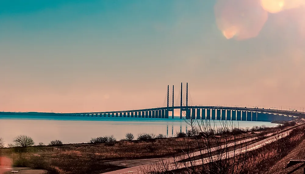
The Sweden-Denmark border is purely a maritime boundary, and it has existed since 1658. The Sweden-Denmark border is along Oresund and Kattegat and in the Baltic Sea right between Scania and Bornholm. Their international water meet along Oresund, and it stretches for 71 miles between Falsterbo and Hoganas. The only crossway connecting the two countries is the Oresund Bridge. The bridge extends for over 5 miles from the coast of Sweden to the Peberholm (an artificial island). A 2.5 miles Drogden Tunnel connects Peberholm and Amager (a Danish island). It is the longest combined rail and road bridge in the continent which connects two main metropolitans (Malmo and Copenhagen).
3) Norway
Norway occupies an area of about 148,747 sq miles and has a population of over 5,258,317. It shares a long boundary with Sweden (1,006 miles) to the east, Russia and Finland to the northeast, and a maritime border with Denmark across the Skagerrak Strait. The country has both political and administrative subdivisions on two levels (municipalities and counties). The Sami community has a certain amount of influence and self-determination over various traditional territories through the Finnmark Act and Sami Parliament. Norway has close ties with the United States and the European Union. It is the founding member of the NATO, Council of Europe, Nordic Council, Antarctic Treaty, and the United Nations.
Norway is a sovereign state which is on the northwestern parts of Europe whose core territory includes the northernmost and western parts of the Scandinavian Peninsula, the Svalbard archipelago and the Jan Mayen Island. The country also lays claim on the Queen Maud Land in Antarctica. Bouvet Island and the Antarctic Peter Island are both dependent territories and therefore not part of the Kingdom of Norway.
Denmark is located due south of Norway, and historically Denmark-Norway, and Sweden were one state under the Kalmar Union which broke up in 1523. The present-day Norway-Sweden boundary served as the border between Sweden and Denmark-Norway until 1814 when Norway and Denmark separated under the Kiel Treaty with Denmark retaining Faroer and Greenland. Currently, the boundary between the Norwegian and Danish Exclusive Economic Zone runs along Skagerrak between Norway and Faroer in the North Sea and Svalbard and Greenland in the Arctic.


