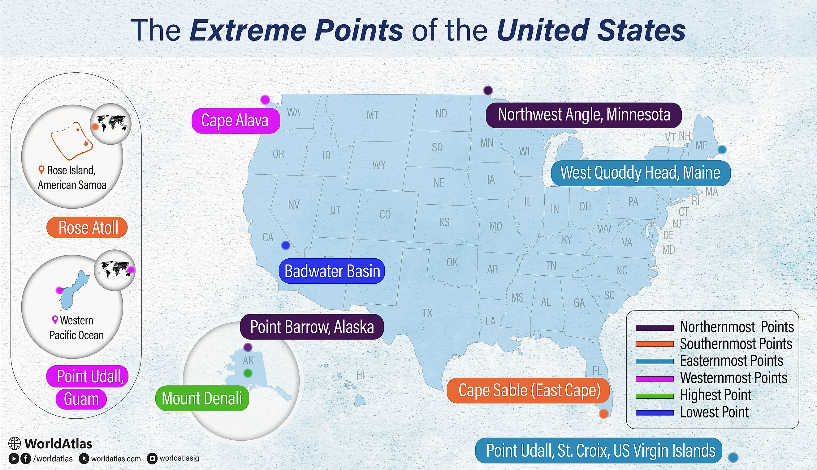
The Extreme Points Of The United States
On a classroom map, it seems obvious where the US begins and ends, but the country's true extreme points tell a far stranger story. They stretch from icy Point Barrow in Arctic Alaska to tiny Rose Atoll in tropical American Samoa, from Point Udall in St. Croix catching the first New Year’s sunrise to Point Udall in Guam watching one of the last sunsets, with Denali towering above and Badwater Basin sunk far below sea level.
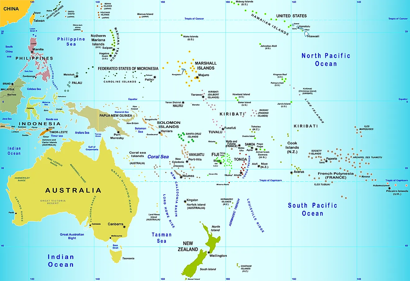
In short, the US extreme points are: Point Barrow (north), Rose Atoll (south), Point Udall, St. Croix (east by travel), Point Udall, Guam (west by travel), Denali (highest), and Badwater Basin (lowest).
This list also reveals how misleading our mental map can be. Many "extreme" points Americans think of, like Key West or the tip of Maine, are only extremes of the contiguous states. The true edges often lie in distant territories, remote parks, and little-visited peninsulas.
Contents:
Northernmost Points In The US
1. Point Barrow, Alaska

Point Barrow (Nuvuk) is the northernmost point of all the territories in the US. Located at 71°23'20"N 156°28'45"W, Point Barrow is a promontory that is situated on the coast of the Arctic Ocean in the State of Alaska. This significant geographical landmark demarcates the limit between the two important marginal seas of the Arctic Ocean, the Beaufort Sea in the east and the Chukchi Sea in the west. Point Barrow was first explored by Frederick W. Beechey in 1826, who named it in honor of the British geographer Sir John Barrow.
Point Barrow is usually covered with ice throughout the year and only remains ice-free for about two to three months. For several years, the Point has served as a jumping-off point for Arctic expeditions. Archaeological findings have revealed that before the arrival of Europeans to North America, the Point Barrow area was inhabited by the ancestors of the Iñupiat people. The point is also a notable archaeological site, and several artifacts of the Thule culture have been discovered in the area.
2. Northwest Angle, Minnesota

The Northwest Angle inlet is the northernmost point in the 48 contiguous United States. Located at 49°23'04.1"N 95°9'12.2"W, Northwest Angle is situated on the northern side of Lake of the Woods County in the State of Minnesota. The Northwest Angle is the only point in the continental United States that is positioned to the north of the 49th parallel, which marks a large portion of the US-Canada border. It is bordered by the Canadian provinces of Ontario and Manitoba and is separated from the State of Minnesota by the Lake of the Woods. The Angle inlet is a small unincorporated community that is a part of the Angle Township in Lake County, Minnesota.
Southernmost Points In The US
1. Rose Atoll

Rose Atoll is the southernmost point in the United States. Covering a land area of only 0.214 km2, this small oceanic atoll is located in the unincorporated US territory of American Samoa at 14°34'11"S 168°9'10"W. The atoll was first discovered by the French explorer Louis de Freycinet in 1819, and it became part of the territory of American Samoa in 1899. The uninhabited Rose Atoll is a significant wildlife refuge and provides critical habitats for a variety of seabirds, fish, endangered turtles, and marine mammals.
2. Cape Sable (East Cape)

Cape Sable is the southernmost point of the US mainland. The Cape Sable peninsula is located at 25°7'6"N 81°5'11"W in the southwestern portion of the US State of Florida and forms a part of the Everglades National Park. The most prominent points on the cape are the East Cape, the Northwest Cape, and the Middle Cape. Several lakes and spectacular sand beaches are also found here. The cape provides critical habitats for the Florida gopher tortoise, Cape Sable seaside sparrows, and Mangrove diamondback terrapin.
Easternmost Points In The US
1. Point Udall, St. Croix, US Virgin Islands

Located on the eastern edge of the island of St. Croix in the US Virgin Islands is Point Udall, which by traveling distance is the easternmost point of the United States. The point was named after Stewart Udall, who served as Secretary of the Interior under the US Presidents Lyndon Johnson and John F. Kennedy. Positioned just above Point Udall is the Millennium Monument, which is a stone sundial that was erected to mark the azimuth of the first sunrise in America of the 2000 New Year. The areas surrounding Point Udall are composed of rotated and uplifted volcanic rocks that are said to have originated during the Upper Cretaceous period.
2. West Quoddy Head, Maine

West Quoddy Head is the easternmost point in the continental United States. Located at 44°48'55.4"N 66°56'59.2"W, the West Quoddy Head is a peninsula situated in the southeastern portion of Lubec, Maine. Major areas of the peninsula form a part of the Quoddy Head State Park. A lighthouse was constructed on the peninsula in 1808 to guide the navigation of the ships through a strait called Quoddy Narrows, which runs between Lubec and Canada’s Campobello Island.
Westernmost Points In The US
1. Point Udall, Guam

Located at 13°26'51"N 144°37'5.5"E, on the Orote Peninsula in the unincorporated US territory of Guam, is Point Udall, which by traveling distance serves as the westernmost point in the United States. The point was originally referred to as Orote Point but was renamed “Point Udall” in honor of Morris Udall, the former congressman from the US State of Arizona, in May 1987.
2. Cape Alava

Situated in the Olympic National Park in Clallam County, Washington, is Cape Alava, the westernmost point in the 48 contiguous United States. The Cape has been named in honor of the Spanish Don, José Manuel de Álava.
Highest Point In The US

Situated near the heart of the Alaska Range in the south-central portion of Alaska is Mount Denali, the highest point in the United States. Formerly known as Mount McKinley, Mount Denali rises to an elevation of 6,190 m and is the highest mountain peak in the continent of North America. After Aconcagua and Everest, Mount Denali is the world’s third most isolated and prominent peak. Mount Denali features two notable summits, the North and the South Summits, that rise about 5,500 m from the Denali Fault. There are several glaciers in the Denali mountain slopes including the Kahiltna Glacier, Muldrow Glacier, Peters Glacier, Ruth Glacier, and Traleika Glacier.
Lowest Point In The US

Located in California’s Death Valley National Park is Badwater Basin, which is considered the lowest point in the United States. This endorheic basin reaches a depth of about 86 m below sea level. The various salt flats in this area cover about 518 km2 and mainly contain sodium chloride, gypsum, calcite, and borax. Despite the high salinity of its water, the basin supports salt-tolerant plants like pickleweed along with several aquatic insects and the endemic Badwater snail.