- Coastline:
1,327 miles (2,137 km)
- Land Area:
(land) 309,130 sq miles (800,642 sq km)
(water) 3,398 sq miles (8,802 sq km)
(TOTAL) 312,528 sq miles (809,444 sq km)
To convert sq km (kilometers) to sq mi (miles)
use our converter - Land Area: (all countries)
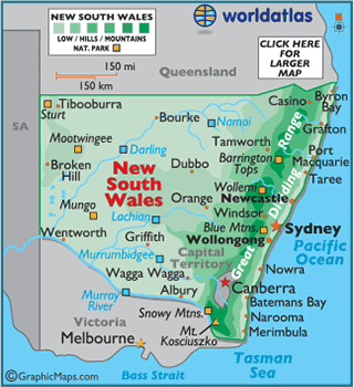
- Land Divisions: There are 141 counties within New South Wales.
- Horizontal Width: 650.94 miles (1,047.59 km) from Broken Hill east to Taree
- Vertical Length: 345.55 miles (556.1 km) from Tibooburra south to Mildura
Note: Lengths and widths are point-to-point,
straight-line measurements from a Mercator map projection, and will vary
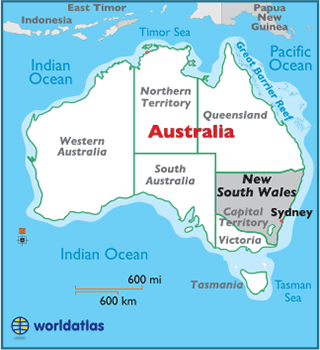
some using other map projections - Bordering States/Territories: (4)
Queensland, South Australia, Victoria, and the Capital Territory
- Geographic Center: About 67.18 miles (108.11 km) south of Dubbo
- Highest Point: Mt. Kosciuszko 7,310 ft (2,228 m)
- Lowest Point: Pacific Ocean 0 m
- Latitude and Longitude
- Relative Location