The State Parks Where Rivers Carved The Landscape
It took millions of years for rivers to carve America's greatest cliffs and canyons. But much like the postcards that capture them, many people only focus on the big picture. Grand Canyon National Park welcomes over 5 million annual visitors, yet many never leave its rim. In contrast, these river-carved state parks have fewer crowds than the Grand Canyon, letting parkgoers explore at a slower pace. Waterfalls, lava flows, and hoodoos are just some of the extraordinary details to see in these prehistoric landscapes.
Letchworth State Park, New York

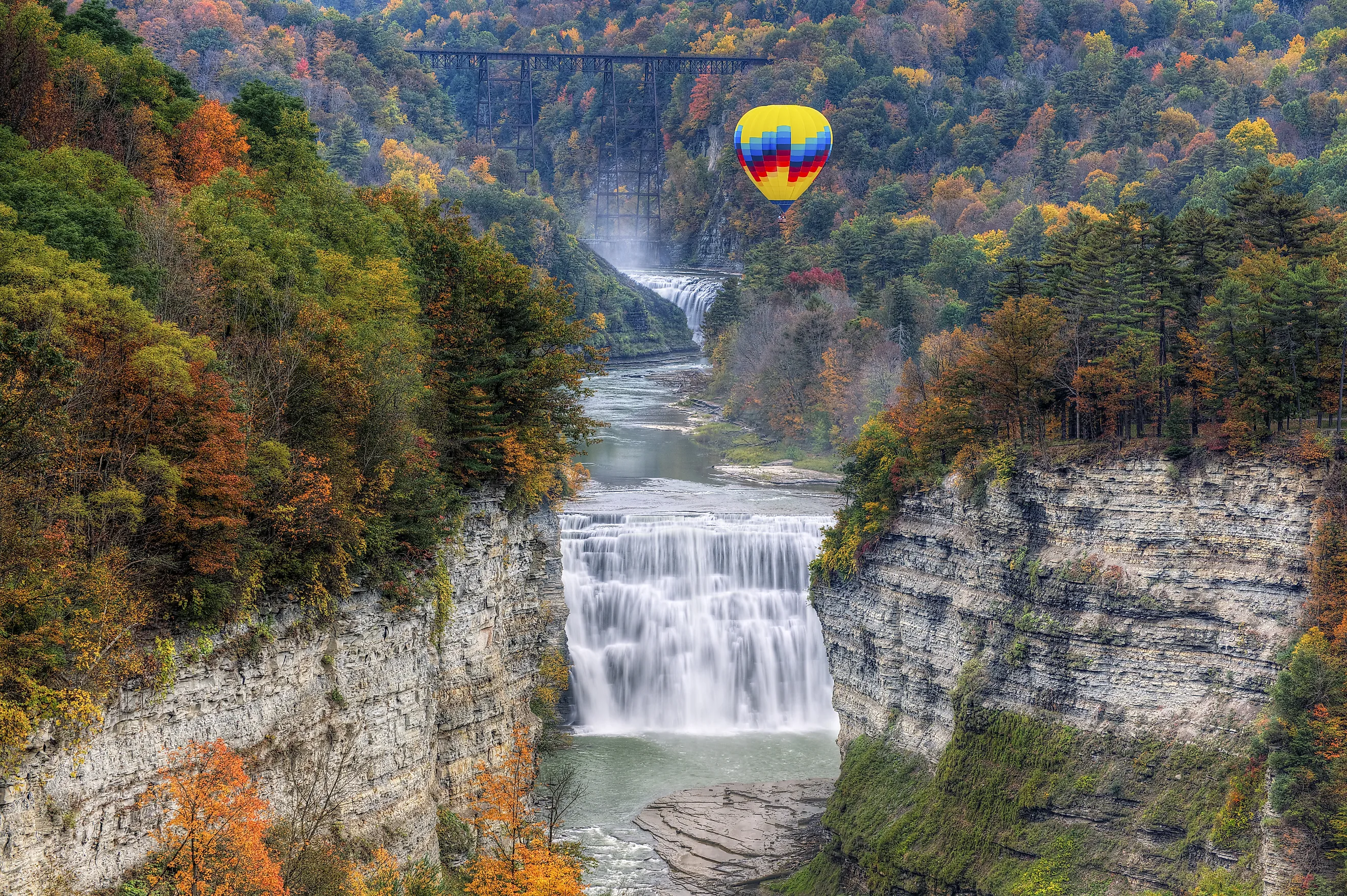
Over 1 million people visit Letchworth State Park annually to see the "Grand Canyon of the East." The Letchworth Gorge is the source of this nickname, running through the heart of the park. Flowing through its center for 17 miles, the Genesee River is the artist that carved this postglacial gorge. Its canyon walls rise up to 600 feet high, framing the waterway and its waterfalls.
A 7-mile Gorge Trail lets hikers see the sweeping landscape from overhead. The rim hike leads to overlooks like Inspiration Point, where hikers can see the Genesee Arch Bridge, river, and Upper Falls. Also visible, Middle Falls is the park's largest waterfall, at 107 feet tall and 300 feet wide. For an even higher view, seasonal hot air balloon rides are an epic way to soar above the gorge. Balloons Over Letchworth operates from May through October.
Palo Duro Canyon State Park, Texas

Palo Duro Canyon has a similar claim to fame as the "Grand Canyon of Texas." The namesake park spans over 25,000 acres in the Texas panhandle. At 120 miles long, 20 miles wide, and up to 800 feet deep, Palo Duro is the second largest canyon system in the United States. Geologists estimate that the Red River's main tributary, the Prairie Dog Town Fork, took 1 million years to shape the colossal canyon we see today.
Palo Duro's colorful walls tell an even older story. Four distinct layers give the canyon its fiery stripes, representing over 250 million years of geologic history. For panoramic views of the landscape, the CCC Overlook sits on the canyon rim. From there, the CCC trailhead lets hikers descend 500 feet to the canyon floor. The Lighthouse Trail is the most popular path in the park, navigating through the base. The 2.8-mile path leads to a tall sandstone hoodoo shaped like a lighthouse.
Fall Creek Falls State Park, Tennessee

Waterfalls plunge from river-sculpted cliffs at Fall Creek Falls State Park. Carved into the Cumberland Plateau, this Tennessee park has a dramatic contrast of uplands and gorges. Cane Creek, a tributary of the Caney Fork River, chiseled most of its sandstone chasms. Today, it feeds Cane Creek Falls, the park's largest waterfall by volume. Fall Creek, a tributary of Cane, also supplies the park's namesake spill. With a 256-foot drop, Fall Creek Falls is the tallest waterfall in Tennessee.
For an easy waterfall hike, the Fall Creek Bike Trail leads to the Fall Creek Falls Overlook in under a mile. From there, the optional Base Of Falls Trail can be hiked for a different angle. Short and challenging, this 0.35-mile route takes adventurous trekkers to the gorge floor. Alternatively, a suspension bridge back up top lets hikers see the waterfall's upper edge. This tree-top view also highlights the nearby Cane Creek Cascades and nearby Rockhouse Falls.
Dead Horse Point State Park, Utah

High on Utah's Colorado Plateau, Dead Horse Point State Park has epic sightseeing. Located 30 miles from Moab, this desert park has some of the best vistas in the country. 2,000 feet below, the Colorado River surges through a gooseneck bend, flanked by the chasm it carved. Unlike other state parks, visitors are bound to the canyon's rim, with no trails leading to its floor. Nonetheless, over 1 million people come here annually to hike and look down.
The canyon's rock layers reveal 300 million years of history, banded with red, rust, and tan strata. Dead Horse Point is the most-visited spot to see these layers, offering a 360-degree view of the bend. The peninsula overlook is easy to reach, just 200 feet one way on a paved path. For another perspective, the 1.5-mile Bighorn Overlook Trail is more rugged and remote, featuring a different angle and fewer crowds.
Waimea Canyon State Park, Hawaii

Waimea Canyon State Park in Hawaii tells a prehistoric story with its volcanic walls. Located on the island of Kauai, the centerpiece gorge is 14 miles long, 1 mile wide, and over 3,600 feet deep. Working with runoff from Mount Waialeale, the Waimea River carved the canyon from millions-of-years-old lava flows. Exposed to air and water, the iron-rich basalt rusted to reveal the red cliffs we see today. Explosive eruptions also reflect in its lighter ash layers, while red strips of laterite record long periods of erosion.
Visitors can sightsee with a bird's-eye view of the park on Waimea Canyon Drive. Pull-offs and overlooks are spaced along the route, letting parkgoers marvel at the colorful canyons. Early into the drive, Red Dirt Falls is a unique stop with a waterfall spilling over red volcanic dirt. Further in, at 3,640 feet high, the Puʻu Hinahina Lookout provides dramatic vistas and connects to the popular Canyon Trail. This hike leads to the top of Waipoo Falls, a waterfall with an 800-foot drop.
Cottonwood Canyon State Park, Oregon

Situated in north-central Oregon, Cottonwood Canyon is another state park carved through ancient lava flows. The John Day River and its tributaries eroded and cut through the Columbia Plateau's basalt over millions of years. Its main cliffs tower nearly 2,000 feet above sea level. Nearby, 4 side canyons can also be explored. Both the volcanic cliffs and canyons are encircled by rocky grasslands and riverbanks filled with wildlife.
Hiking is a popular way to experience Cottonwood Canyon State Park. The Lost Corral Trail and Pinnacles Trail run parallel on opposite sides of the John Day River for 4.3 miles. Both paths offer wildlife viewing, with the chance to spot Rocky Mountain elk, California bighorn sheep, and mule deer. For river-based sightseeing, the park's J.S. Burres day-use area has a boat launch for kayaks and canoes.
Landscapes Beyond The Grand Canyon
These river-carved state parks may get fewer guests than the Grand Canyon, but they are no less sublime. Better yet, a lack of national park crowds lets parkgoers slow down and appreciate the details. Looking closer, parkgoers can see Palo Duro Canyon's geological eras striped into its rocks. Fall Creek Falls also lets hikers descend a gorge for a different angle of its powerful waterfalls. Even Dead Horse Point State Park features an out-of-the-way hike to breathe in views from a different perspective.