The Best Desert State Parks In The West
State parks across the American West protect landscapes defined by extreme aridity. Geological forces have carved slot canyons into red sandstone, and wind has sculpted gypsum into dunes rising hundreds of feet above the basin floor. These environments rely on specific climatic thresholds, with annual precipitation often falling below ten inches, to maintain the fragile biological soil crusts that prevent erosion and support specialized flora like the Joshua tree and ocotillo. Eight state parks across California, Nevada, Arizona, and Utah preserve these distinct desert ecosystems. They offer access to some of the most starkly beautiful and geologically significant terrain in North America.
Anza-Borrego Desert State Park, California

Spanning 650,000 acres in the Colorado Desert, Anza-Borrego stands as the largest state park in California, protecting a landscape of badlands, slot canyons, and palm oases. The park's geology features the eroded sediments of the ancient Lake Cahuilla, exposing layers of sandstone and mudstone that contain fossilized remains of Pleistocene mammals such as camels and giant ground sloths.
During wet years, the dormant seeds of desert wildflowers germinate en masse, creating a "superbloom" that transforms the brown scrubland into a carpet of purple sand verbena and orange poppies, a phenomenon dependent on precise rainfall timing between October and March.
The terrain includes a slot canyon, narrow fissures where water has cut vertically through soft rock, creating passages barely wide enough for a single person. The Slot Canyon Trail is a 2.2-mile loop that winds throughout the narrow floor of the slot canyon.
The park contains over 500 miles of dirt roads and hiking trails, ranging from paved access to the visitor center to rugged routes requiring high-clearance vehicles. Metal sculptures by artist Ricardo Breceda are scattered throughout the park, depicting prehistoric creatures that once roamed the region, blending art with the paleontological history of the basin. Temperatures here frequently exceed 110 degrees Fahrenheit in summer, restricting visitation to the cooler months between November and April.
Valley of Fire State Park, Nevada

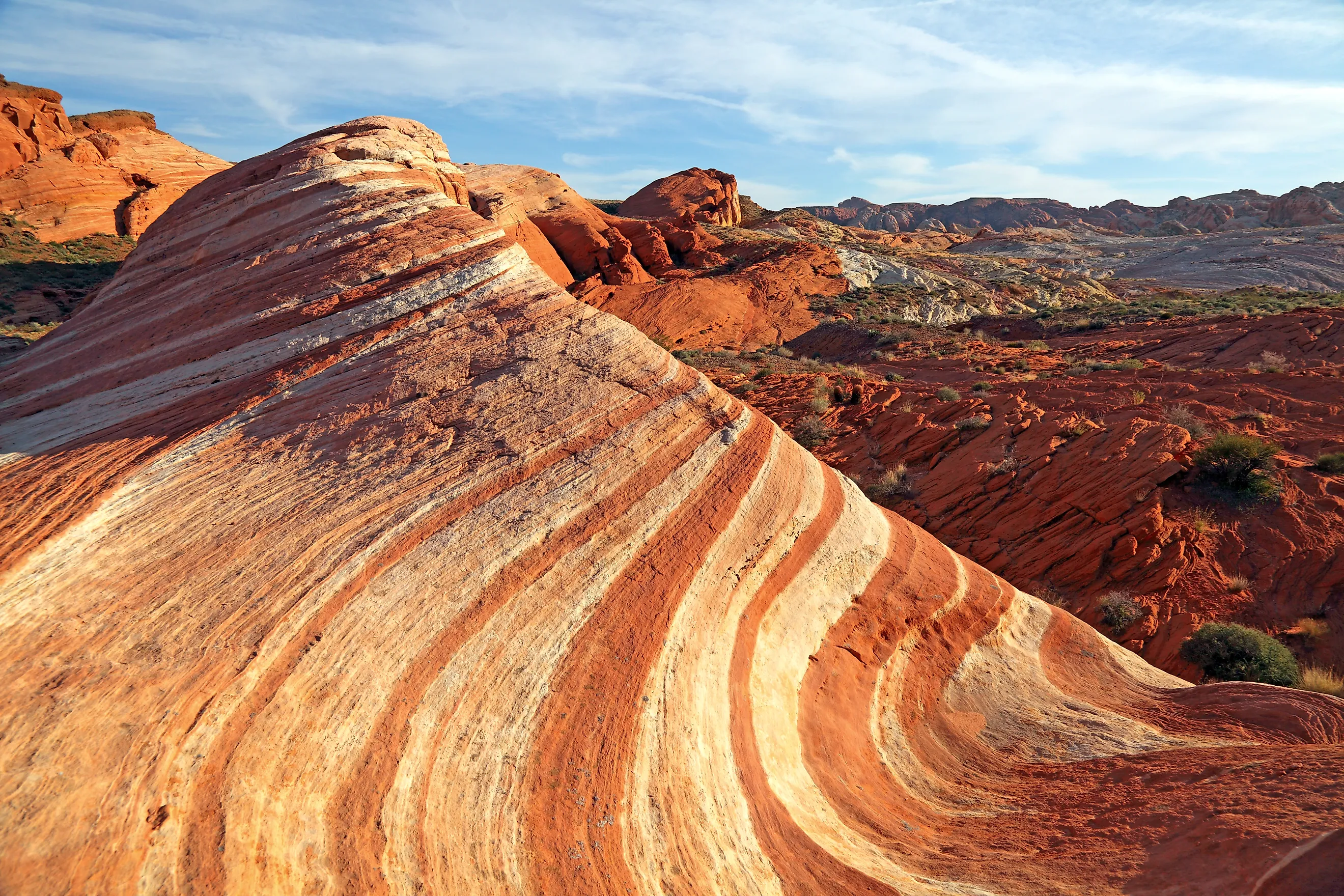
Ancient sandstone formations glow with intense red hues in Valley of Fire, Nevada's oldest and largest state park. The Aztec Sandstone, deposited during the Jurassic period approximately 150 million years ago, was pushed to the surface by tectonic activity and eroded into swirling shapes, arches, and balanced rocks. The iron oxide within the sandstone gives the landscape its signature crimson color, which appears most vibrant during sunrise and sunset when the low angle of the sun enhances the saturation.
The park covers nearly 46,000 acres and contains petroglyphs carved by the Ancestral Puebloans over 2,000 years ago, visible at sites like Atlatl Rock and Mouse's Tank. These carvings depict bighorn sheep, hunters, and abstract symbols.
Temperatures in the Mojave Desert here can soar above 120 degrees Fahrenheit in July, making winter and spring the primary seasons for hiking trails like the Fire Wave or the White Domes loop.
Goblin Valley State Park, Utah

Thousands of mushroom-shaped sandstone formations, known as hoodoos or "goblins," populate a secluded valley in south-central Utah. These hoodoos are carved from the Entrada Sandstone itself, where variations in cementation left some layers harder than others, and wind and water have eroded the goblin shapes. Over millions of years, the softer, less-cemented rock wore away faster than the resistant layers, leaving the pillars standing in isolation across the valley floor. The formations range in height from a few feet to over 20 feet, creating a labyrinthine landscape that invites exploration.
The park encompasses 3,654 acres, with the main valley floor open to free-roaming hiking. Unlike parks with designated trails, visitors here are encouraged to wander among the goblins, navigating the uneven terrain of clay and sand.
The remote location, situated off Highway 24 near Green River, ensures low light pollution, making the park a designated International Dark Sky Park. Night skies here reveal the Milky Way with exceptional clarity, unobstructed by urban glow. The geology continues to evolve, with new goblins forming and old ones collapsing as erosion persists.
Picacho Peak State Park, Arizona

A volcanic plug rising 1,500 feet above the Sonoran Desert floor marks the centerpiece of Picacho Peak State Park. This peak is made of a volcanic rock remnant leftover by lava flow from ancient volcanoes that erupted approximately 22 million years ago, leaving behind hardened magma that resisted erosion while the surrounding sedimentary rock wore away.
The park protects a diverse array of Sonoran Desert flora, including the iconic saguaro cactus, which blooms with white flowers in late spring. Hiking trails like the Hunter Trail ascend the peak via steep inclines and metal cables, requiring physical exertion and caution due to loose rock.
Picacho Peak State Park sits along Interstate 10, making it a visible landmark for millions of travelers, yet the interior trails offer a quiet immersion into the desert ecosystem. After a strenuous hike, the view from the 3,374-foot summit of the park offers panoramic views of the expansive Sonoran Desert floor, Picacho Mountains, and Newman Peak to the north.
Dead Horse Point State Park, Utah

Perched 2,000 feet above the Colorado River, Dead Horse Point offers a panoramic vista of the Canyonlands region that rivals any overlook in the national park system. The mesa is capped by the resistant Kayenta Formation, which overlies the Wingate Sandstone that forms the sheer cliff edge dropping vertically into the canyon below, where multiple rock layers lie exposed. The Colorado River winds through the canyon floor in a gooseneck bend, a geological feature formed by meandering water cutting through uplifted rock layers over millions of years.
The park covers 5,362 acres and features a network of rim trails that traverse the mesa top, offering unobstructed views of the river canyon and the distant La Sal Mountains. The arid climate supports pinyon pine and juniper woodlands, which contrast with the bare rock of the point. Wind speeds on the plateau are often high, shaping the vegetation and creating a constant acoustic backdrop.
The site's elevation provides cooler temperatures than the valley floor, allowing for year-round visitation, though summer afternoons can still be intensely hot. The view encompasses the snow-capped La Sal Mountains in the distance, providing a stark contrast to the red rock foreground.
Red Rock Canyon State Park, California

Stratified bands of red, white, and tan sedimentary rock define the landscape of Red Rock Canyon State Park in the Mojave Desert. These layers represent millions of years of deposition in ancient lake beds and river systems, later uplifted and tilted by tectonic activity along the Garlock Fault. The fault line runs directly through the park, creating dramatic cliffs and exposing the geological history of the region in vivid cross-sections.
The park protects 27,000 acres of rugged terrain, including Hagen Canyon, where hyper-arid conditions have sculpted the soft mudstone into fantastical hoodoos and formations like Turk's Turban and Camel Rock. The landscape is bone-dry, characterized by eroded badlands and sparse desert scrub rather than lush vegetation. Temperatures fluctuate wildly, from freezing nights in winter to scorching days in summer, requiring visitors to prepare for extreme conditions.
The area has served as a filming location for numerous Westerns and science fiction movies, its alien-like landscape doubling for other worlds. Hiking trails range from easy walks to strenuous climbs up the fault scarp, offering views of the El Paso Mountains and the stark beauty of the eroded basin.
Catalina State Park, Arizona

Saguaro cacti by the thousands populate the slopes of the Santa Catalina Mountains at Catalina State Park. Located just north of Tucson, this 5,500-acre park protects a dense forest of these towering saguaro cacti, which can live for over 150 years and reach heights of 40 feet.
The park features over 5,500 acres of hiking, horseback riding, and mountain biking trails, including the 5.6-mile round trip Romero Canyon Trail which leads to a historic canyon ranch. Water flows seasonally through Romero Canyon, creating temporary pools that attract wildlife such as javelina and coyotes.
The proximity to a major metropolitan area makes it a popular destination for sunrise hikes, yet the extensive trail system allows visitors to find solitude away from the trailheads. The geological foundation consists of volcanic rock and granite, weathered into the rugged peaks that frame the desert floor.
Kodachrome Basin State Park, Utah

Sedimentary pipes of sandstone rise like colorful chimneys from the desert floor at Kodachrome Basin State Park. These geological features, known as sedimentary pipes, formed when pressurized sand injected upward through cracks in the surrounding rock layers, hardening into columns that resisted erosion while the softer surrounding material wore away. The park contains 67 such pipes, ranging in height from 6 to 170 feet, displaying hues of red, white, pink, and gold derived from iron and manganese oxides.
Situated in southern Utah near Bryce Canyon, the park covers 2,200 acres of high desert terrain at an elevation of 5,800 feet. The cooler altitude allows for a mix of desert vegetation and pinyon-juniper woodlands, creating a unique ecological transition zone.
Hiking trails like the Panorama Trail loop through the basin, offering close-up views of the pipes and the surrounding eroded badlands. The park's remote location ensures dark night skies, and the lack of large crowds allows for a quiet observation of the geological oddities that define the landscape.
The Western Desert State Parks
These eight state parks collectively protect hundreds of thousands of acres of desert terrain, preserving geological features that range from ancient volcanic plugs to sedimentary sand pipes. From the badlands of Anza-Borrego to the red sandstone fins of Valley of Fire, these sites maintain the specific environmental conditions that define the American West's arid landscapes.
Management of these lands requires balancing public access with the preservation of fragile ecosystems, where a single footstep can damage biological soil crusts that took decades to form. The thermal extremes and water scarcity inherent to these regions demand respect and preparation from visitors. By maintaining these parks, state agencies ensure that the geological and ecological signatures of the desert remain intact for future observation and study.