Where Is The World's Largest Plateau?
Referred by various names such as the Qinghai-Tibet Plateau, Qing-Zang Plateau, and Himalayan Plateau, the Tibetan Plateau, with an average elevation of more than 14,800 feet and covering an area of about 970,000 square miles, is the highest and largest plateau in the world above sea level. Placed at the meeting point of East, Central, and South Asia, this expansive elevated plateau covers a significant portion of the Tibet Autonomous Region and the Chinese province of Qinghai, the western section of Sichuan, the southern portion of Gansu, the northwestern part of Yunnan, and the Ali area of the Xinjiang Uygur Autonomous Region. The Tibetan Plateau also covers portions of the Kingdom of Bhutan, the Indian Union Territory of Ladakh, the Lahaul and Spiti district of the Indian State of Himachal Pradesh, the northwestern part of Nepal, the eastern part of Tajikistan, the southern part of Kyrgyzstan, as well as the Gilgit-Baltistan region of Pakistan. Often called the “Roof of the World,” the Tibetan Plateau is surrounded by several impressive mountain ranges hosting the highest summits: Mount Everest and Mount K2.
Geography Of The Tibetan Plateau

From east to west, the Tibetan Plateau has a maximum length of 1,600 miles, and from north to south, it has a maximum width of about 620 miles. The plateau is bordered by the Kunlun Mountains in the north, the Himalayan Mountain range in the south, and the Qilian Mountains in the northeast. The plateau gives way to a forested gorge and ridge in the east and southeast; whereas in the west, it is embraced by Northern Kashmir’s rugged Karakoram Mountain range. The Kunlun Mountains separate the plateau from the Tarim Basin; while the Altyn-Tagh Mountain range separates it from the eastern portion of the Tarim Basin. The Qilian Mountains separate the plateau from the Gobi Desert and the Hexi/Gansu Corridor; whereas the mighty Himalayan Mountains form a barrier between the plateau and the alluvial plains of the Indian Subcontinent. The Hengduan Mountains link the southeastern portions of the Tibetan Plateau with the Yunnan-Guizhou Plateau.

The Tibetan Plateau is sometimes called the world’s Third Pole since its ice fields hold the biggest freshwater storage outside the Arctic and the Antarctic polar regions. The Tibetan Plateau also serves as the source of many major rivers in Asia, including the Mekong, Yangtze, Tarim, Indus, Salween, Huang He, and Brahmaputra rivers. Considered a “high-altitude arid steppe” dotted with colossal mountain ranges, the Tibetan Plateau contains many glaciers and huge brackish lakes, which function as a “water tower,” maintaining streamflow and water storage.
The height of the Tibetan Plateau increases progressively as one moves from the plateau’s northern side to its northwestern side to the Changtang region, where the average altitude is more than 16,000 feet, with winter temperatures dropping to about -40°F. All these conditions make Changtang and its adjacent Kekexili region Asia’s least populous region and the world’s third-least populous area after Northern Greenland and Antarctica.
Geology Of The Tibetan Plateau

The Tibetan Plateau shares a similar geological history with that of the Himalayas. The uplifting of the sedimentary and metamorphic rocks that created this mighty mountain range during the Alpine Orogeny also led to the creation of the Tibetan Plateau. Scientific studies have revealed that this creation dates back to about 70 million years ago, during the Upper Cretaceous period, due to the continental collision between the Indo-Australian and Eurasian Plates along the convergent boundary. About 50 million years ago, the swiftly moving Indo-Australian Plate led to the gradual compression and narrowing down of the Tethys Sea. Due to the increased compressive forces, masses of granite and basaltic rocks from the Earth’s mantle were pushed upwards into the weakened sedimentary crust. In due course, the Tethys Sea completely narrowed, and the sea bottom was slowly pushed upwards by the Indi-Australian Plate, creating the Tibetan Plateau. Geologists claim that the Indo-Australian plate is still being moved horizontally beneath the Tibetan Plateau, which is leading to the continuous rising of the plateau at a rate of 0.2 inches per year.
Climate Of The Tibetan Plateau

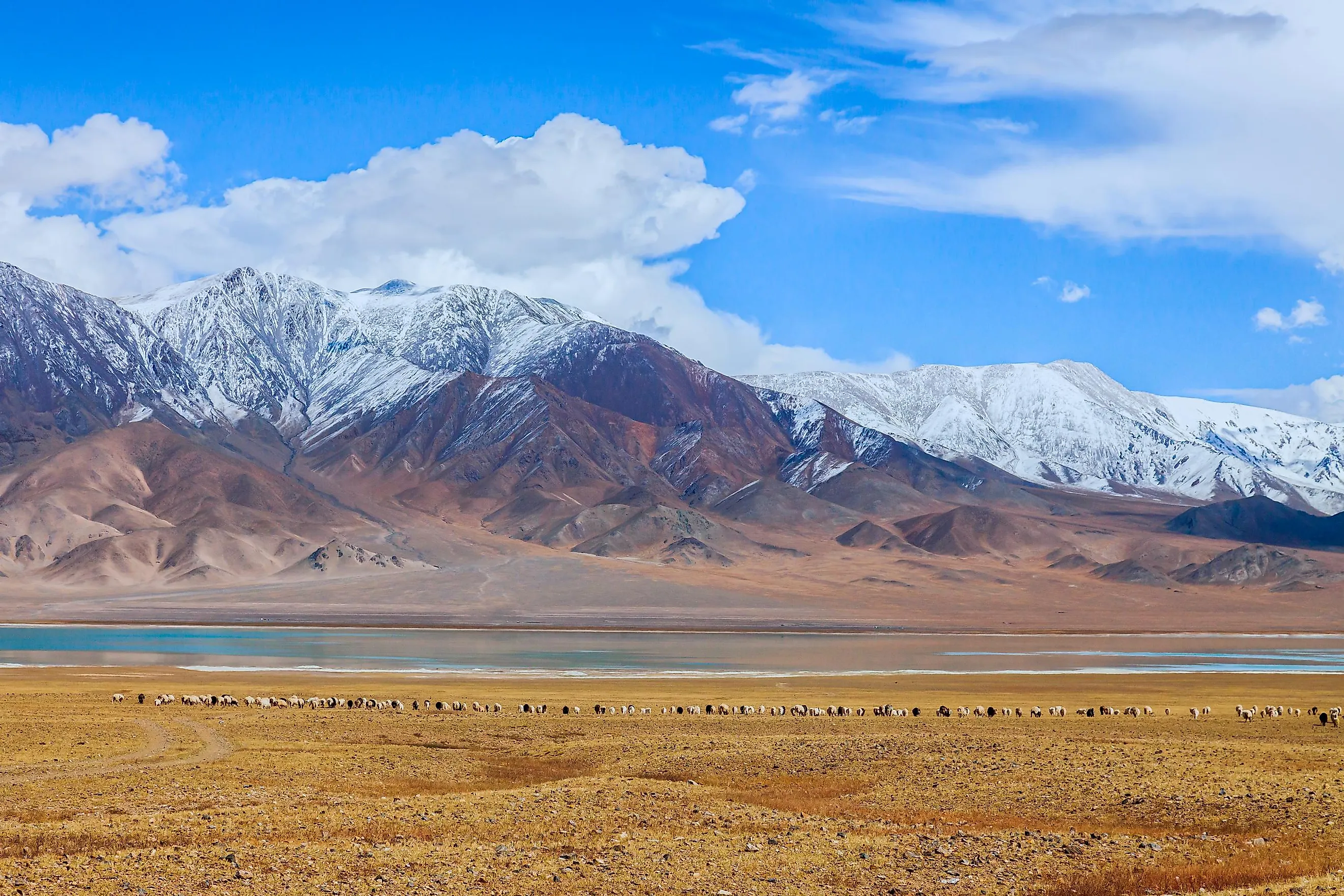
The Tibetan Plateau experiences a typical high-plateau climate, with significant variations in diurnal and monthly temperatures. At the heart of the plateau, the average January temperature is around 32°F, while the June temperature average around 62°F. The Himalayas act as a barrier to the rain-bearing winds from the south, and therefore the plateau receives extremely low yearly precipitation, which ranges between 3.9 to 11.8 inches and mainly falls as hail. Extensive portions of the plateau are covered by permafrost. The plateau’s southern and eastern edges are covered by grasslands that support a population of nomadic herdsmen, even though the area remains covered by frost for more than six months of the year.
The Tibetan Plateau plays an enormous role in maintaining the climatic conditions in Asia. During the hot season, the Tibetan Plateau functions as a massive heat engine, which in turn enhances the summer monsoons in the continent. Likewise, it blocks the cold winter winds from the Siberian highlands during winter, increasing spring rainfall south of the Yangtze River’s lower reaches and premonsoon precipitations in South China.
Ecology Of The Tibetan Plateau

The Tibetan Plateau features an array of ecosystems, a majority of which are considered montane grasslands. Alpine-tundra vegetation covers some portions of the plateau, while other parts that are influenced by monsoons are covered by shrublands and forests. Due to the high elevation and extremely low precipitation, the species diversity is quite reduced on the plateau. Some well-known faunal species observed here include the Tibetan wolf, kiang, wild donkey, snow leopard, wild yak, water buffalo, etc. Some snakes and many avian species like cranes, geese, vultures, and hawks are also found in the plateau region. The Himalayan jumping spider (Euophrys omnisuperstes) is an amazing arachnid observed here that can live at elevations of over 21,300 feet. According to the World Wide Fund for Nature (WWF), about 17 ecoregions are found on the Tibetan Plateau.
Human History Of The Tibetan Plateau

As per archaeological evidence, the earliest humans started living on the Tibetan Plateau between 30,000 to 40,000 years ago. Approximately 40% of the ethnic Tibetan population is constituted by pastoral nomads who reside on the plateau and sustain on the grasslands to feed their livestock. Since the plateau’s colonization, Tibetan culture started to spread and flourish in the plateau's eastern, western, and southern regions. One of the most well-known civilizations that developed on the Tibetan Plateau from the 7th to 9th century AD was the Tibetan Empire. The plateau’s principal population center is Lhasa – Tibet’s capital city and a significant cultural, economic, and transportation center.
The world’s highest and most extensive plateau also contains the most expansive area of low-latitude glaciers, which holds the world’s third-largest ice storage. However, in recent times, due to anthropogenic climate change and global warming, these glaciers are retreating much faster. It has been estimated that more than 80% of the Tibetan glaciers have retreated in the last five decades. This melting of glaciers will lead to the expansion of the lakes, extensive floods and mudflows, and the lowering of the water supply of vital Asian rivers. Once these vanish, the inhabitants of those regions that depend on the water bodies would be in grave danger.


