Karakoram Mountains
Mountains cover about 26.5% of the world’s total land surface and harbor over one-third of the global terrestrial biodiversity. The Karakoram is a large mountain range that stretches along the international boundaries of India, Pakistan, and China, with its northwestern edge extending into the countries of Afghanistan and Tajikistan. The Karakoram Mountain range forms the northwestern extension of the greater Himalayan Mountain system and is the world’s 2nd highest mountain range that covers a total area of about 207,000 sq. km.
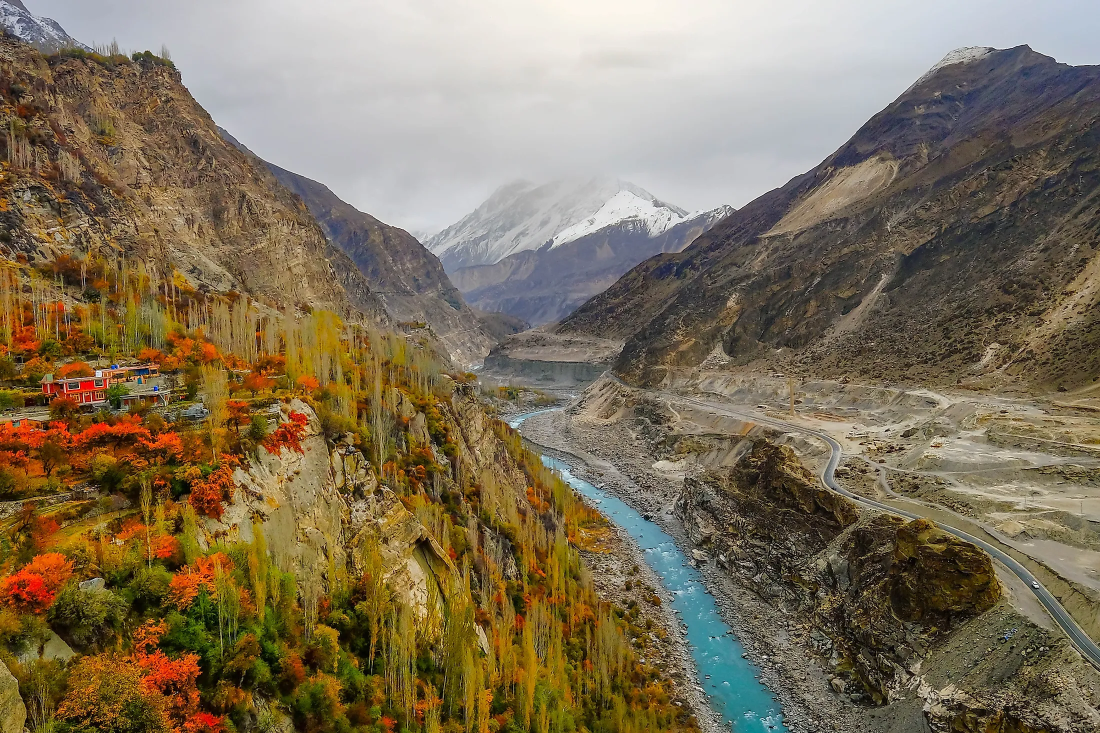
The Karakoram Mountain range starts at Afghanistan’s Wakhan Corridor and occupies a major part of the Gilgit-Baltistan region of Pakistan, also extending into the Indian Union Territory of Ladakh, and the Aksai Chin region of China. The Karakoram Mountain range is bounded by the Aksai Chin plateau on the east; the Tibetan Plateau in the northeast and the Karakash and Yarkand River valleys in the north. The Indus, Gilgit, and Shyok Rivers form the entire southern boundary of the Karakoram Mountain range and separate it from the northwestern edge of the Himalayan range.
Geography

The Karakoram Mountain range forms a part of a complex of high mountain ranges that also includes the Pamir Mountains in the northwest; the Hindu Kush mountains in the west; the Kunlun Mountains in the northeast; and the Himalayan Mountains in the southeast. The mountain range has a length of about 500km and a width of about 240km. The average elevation of the Karakoram Mountain range is about 6,100m and overall, there are about 4 mountains that have an elevation of more than 8,000m and about 18 mountain peaks that have an elevation of more than 7,500m. The Karakoram contains the world’s 2nd highest peak K2 (commonly, Mount Godwin Austen) – which rises to an elevation of 8,611m. The mountain range also contains many high mountains like the Gasherbrum I (8,080m), Gasherbrum II (8,034m), the Broad Peak (8,051m), etc.
| Rank | Peak | Height (in m) |
|---|---|---|
| 1 | K2 | 8,611 |
| 2 | Gasherbrum I | 8,080 |
| 3 | Broad Peak | 8,051 |
| 4 | Gasherbrum II | 8,034 |
| 5 | Gasherbrum III | 7,952 |
| 6 | Gasherbrum IV | 7,925 |
| 7 | Distaghil Sar | 7,885 |
| 8 | Kunyang Chhish | 7,852 |
| 9 | Masherbrum I | 7,821 |
| 10 | Batura I | 7,795 |

Situated in the Karakoram range is the Karakoram Pass, which at an elevation of 5,540m is a high mountain pass between the Republic of India and the People’s Republic of China. The 1,300km long Karakoram Highway passes through the Karakoram Mountain range at an elevation of 4,714m and is considered as one of the world’s highest paved roads. The Karakoram Highway connects the Gilgit-Baltistan region and the Punjab and Khyber Pakhtunkhwa provinces of Pakistan with the Xinjiang Uyghur Autonomous Region of China.
The Karakoram Mountain Range is located in one of the most geologically active regions of the world, at the boundary of the Indo-Australian and the Eurasian continental plates. Geologists have estimated that the Karakorams originated about 65 million years ago in the Cenozoic Era, and the mountains are mainly composed of different types of rocks like granites, phyllites, gneisses, and crystallized schists.

The mountain range is also the most heavily glaciated region outside the planet’s north and south polar regions. It has been estimated that about 28 to 50% of the Karakoram range is glaciated and the glaciers cover an area of more than 15,000 sq. km. It is also to be noted that there are only 8 glaciers in the world that have a length of more than 50km and about 6 of these glaciers are situated in the Karakoram ranges. Some of the longest glaciers that are found here include the 76km long Siachen Glacier, the 63km long Biafo Glacier, the 63km long Baltoro Glacier, the 57km long Batura Glacier, the 49km long Hispar Glacier, and the 41.5km long Yinsugaiti Glacier.
The topography of the Karakoram range is characterized by long slopes, craggy peaks, and taluses. A significant area of the mountain range is occupied by the cliffs and the taluses. The southern slopes of the Karakoram ranges are long and steep, while its northern slopes are comparatively short and steep. Many valleys and hot springs are also found.
Climate

The climate of the Karakoram Mountain range is semiarid for most parts and also continental, as its southern slopes receive the rain-bearing winds from the Indian Ocean. The northern slopes of the mountain range are drier while the lower and middle slopes receive small quantities of rain and snowfall. At elevations of about 5,700m, the average temperature during the warmer months is less than 0°C, while at elevations between 3,900 to 5,700m, the average temperature is less than 10°C. The characteristic climatic features of the region include intensive solar radiation, rarefied air, strong winds, etc. At extreme higher elevations finding snow hummocks of more than 1m are not uncommon.
However, it has been found that as an effect of global climate change, the Karakoram glaciers are retreating much slower than the Himalayan glaciers. This is because many glaciers of the Karakoram are covered by a layer of rubble that provides insulation from the sun.
Flora And Fauna
Different plants like willow, oleander, and poplar are found along the watercourses at elevations of 3,000m. Junipers are found on the higher slopes whereas shrubs belonging to the Artemisia group are found on the lower slopes. Some of the notable animals that are found here include the Marco Polo sheep, Ladakh urials, markhors, Siberian ibex, snow leopards, brown bears, kiangs, lynx, and wild yaks. Birds like Himalayan griffons, golden eagles, and lammergeiers are also found here.
Brief History

The name ‘Karakoram’ is a Turkic term that means ‘black gravel’ or ‘black mountain’. During the 19th century, the German explorer Alexander Von Humboldt interpreted ancient Chinese and medieval Arabic documents regarding the pre-European geographical knowledge about the Karakoram Mountains. The region was visited by notable European travelers like William Moorcroft, George Hayward, George Trebeck, etc. The British surveyors visited the region in 1856. In 1887, Lieutenant Colonel Francis Younghusband successfully crossed the Muztagh Pass and in 1892, the valleys located above the Hunza River were successfully explored by Brigadier-General George Cockerill. Successive explorations in 1910 and 1920 helped in gaining knowledge about the detailed geography of the region. The European explorers were the first to use the name ‘Karakoram’ in the 20th century. During the late 20th and the beginning of the 21st century, the explorations in the Karakoram ranges were mainly conducted by Canadian, American, and British scholars.


