Ozark Mountains
Also known as the Ozark Highlands, Ozark Mountains, and Ozark Plateau, the Ozarks are a thickly forested group of highlands in the United States' south-central portion. Covering parts of the US States of Arkansas, Oklahoma, Kansas, and Missouri, this physiographic region extends southwestwards from St. Louis in Missouri to the Arkansas River. Considered to be the most expansive rugged highland region between the Rocky and the Appalachian Mountains, the Ozarks encompass an area of approximately 47,000 sq. mi. The Ozarks comprise two mountain ranges: Missouri’s St. Francois Mountains and Arkansas’s Boston Mountains. Located in the Boston Mountains, the Buffalo Lookout, which reaches an elevation of 2,561 ft, is the highest point in the Ozarks. Along with the adjacent Ouachita Mountains, the Ozarks form an area known as the U.S. Interior Highlands.
Etymology Of Ozarks

The term “Ozarks” has been derived as an English adaptation of the corrupted French words “aux Arcs,” which means “of/at/to the Arcansas.” It is believed that initially, during the period before the French and Indian War, the term “aux Arkansas” referred to a trading post located in the forested lowland area of the Arkansas Delta immediately above the meeting point of the Arkansas and the Mississippi Rivers. “Ozarks” became a widely used term by the beginning of the 20th century.
Physiographic Subregions Of Ozarks
The four main physiographic subregions which make up the Ozarks include the Boston Mountains, the Springfield Plateau, the Salem Plateau, and the Saint Francois Mountains.
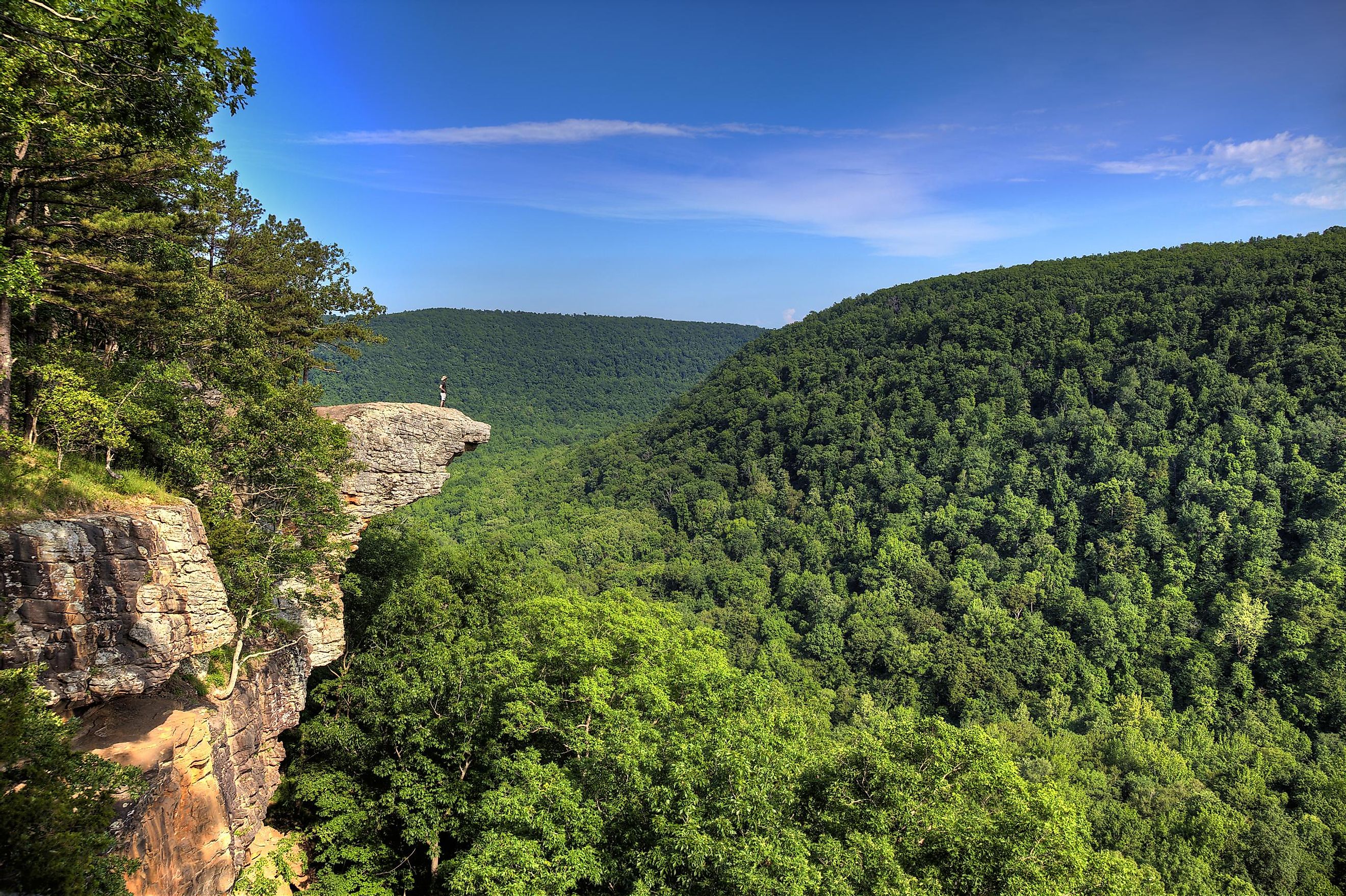
Boston Mountains

The Boston Mountains is a deeply dissected plateau, the highest ridges and peaks of which are underlined by Pennsylvanian sandstone and shale. Forming the Ozark plateau’s southwestern part, the Boston Mountains cover an area of 5,770 sq. mi and contain some of the highest peaks in the Ozarks. Located in the western part of Arkansas’s Newton County, the Turner Ward Knob, with an elevation of 2,463 ft, is the highest-named peak. Several rivers and streams flow out in all directions from the Boston Mountains. These rivers include the White River, Kings River, Little Mulberry Creek, Illinois River, Lee Creek, Buffalo River, War Eagle Creek, Little Red River, etc. In the south, the Boston Mountains are separated from the Ouachita Mountains by the Arkansas River valley.
Springfield Plateau
Underlined by Mississippian cherty limestone, the Springfield Plateau makes up the second-largest geologic area of the Ozarks. The Springfield Plateau occupies the southwestern part of Missouri, the northeastern part of Oklahoma, and the northwestern part of Arkansas. Characterized by low elevation, different karst features like caves, sinkholes, and springs are common in the limestones of the Springfield Plateau. These karst formations are, in turn, separated by steep escarpments interrupted by rolling hills. Although a significant portion of the surface layers of Springfield Plateau has been denuded, massive remnants of younger layers are found at the southern end of the formation. Several broad streams drain the Springfield Plateau region, eventually emptying into the White River.
Salem Plateau

Underlined by older Ordovician dolomites, limestones, and sandstones, the Salem Plateau or Central Plateau makes up the most extensive geologic area of the Ozarks. This plateau region extends across the south-central portion of Missouri and the north-central portion of Arkansas. Like the Springfield Plateau, this area also has low elevation and karst topography. The long, flat plains contain hills and valleys that have been carved by the rivers cutting through them.
Saint Francois Mountains

Rising over the Ozark Plateau, the Saint Francois Mountain range forms the geological core of the highland dome. It is believed that volcanic and intrusive activities about 1.485 billion years ago led to the formation of the Saint Francois Mountains. The igneous and volcanic rocks of these mountains are considered to be the remains of a Proterozoic Mountain range. The core of this mountain range existed as an island archipelago in the Paleozoic seas. Fossilized corals have been observed in the sedimentary layers surrounding this ancient archipelago. These flanking reefs formed localizing structures for ore-bearing fluids, resulting in the area’s rich lead-zinc ore deposits.
The Ouachita Orogeny resulted in the upliftment of the Ozark Plateau during the Pennsylvanian period. The collision of North America with South America during the late Paleozoic lifted a deep ocean basin in the central and southern parts of Arkansas, creating the Ouachita Mountains and the subsequent upliftment of the Ozark Plateau.
Protected Areas In The Ozarks

In 1908, President Theodore Roosevelt’s proclamation to preserve 917,944 acres across five counties of Arkansas led to the creation of the Ozark National Forest and the beginning of formal forest conservation practices in the region. In the later years, more than 544,000 acres were added to the Ozark National Forest. The Mark Twain National Forest was established by the US Congress in 1939 to protect nine critical areas in Missouri. Several wildlife management areas were established to help restore populations to viable numbers. The US Congress also established the Hercules Glades Wilderness in 1976 and the Ozark Plateau National Wildlife Refuge in 1986. The establishment of these protected areas in the Ozarks ensured the recovery of many endangered faunal species like the red wolf, eastern small-footed bat, Ozark big-eared bat, Ozark cavefish, Indiana bat, Ozark cave amphipod, etc. Even though the Wilderness Act of 1964 prevented humans from interfering in wilderness areas, commercial farms and processing operations increased the level of contaminants in the Ozark streams. This, in turn, has posed a severe threat to the endangered local species, water supplies, and recreational use of these water bodies.
Waterways In The Ozarks

The Ozarks serve as the source of many rivers and streams. Most of these rivers and streams have been dammed, and the majority of these dams in the Ozarks region are managed by the U.S. Army Corps of Engineers. Although initially, the dams were built for controlling floods and hydroelectric power generation, at present, these dams perform major economic functions through recreational uses in various places. Some of the biggest lakes in the region, such as Beaver Lake, Table Rock Lake, and Bull Shoals Lake, have been created by the damming of the White River. Other lakes like the Greers Ferry Lake (created on the Little Red River), Norfolk Lake (created on the North Fork River), and Clearwater Lake (created on the Black River) were created on the different tributaries of the White River.
Some other large lakes in the Ozarks include Lake of the Ozarks, Truman Lake, and Pomme de Terre Lake. All these lakes have been formed by the damming of the Osage River and its tributary, the Pomme de Terre River. In 1940, the damming of the Grand River on the western portion of the Ozark Plateau led to the creation of the Grand Lake of the Cherokee. In 1969, the damming of the Sac River led to the creation of Stockton Lake, which helped in supplementing the water supply of the city of Springfield. The rivers and streams of the Ozarks are typically crystal-clear and flow through forested areas along limestone and dolomite bluffs. Due to the presence of a large number of springs and waterways, fish hatcheries are quite common throughout the region.
Economic Significance Of The Ozarks

Many ore deposits of barite, zinc, lead, and iron are present in the Ozarks. Although historic mining activities have depleted a majority of these deposits, currently, the remaining deposits are mined in the Lead Belt district of southeastern Missouri. In addition, a significant portion of the plateau region supports dairy farming and beef cattle ranching activities. Extraction and exploration of petroleum also take place in the eastern section of the Boston Mountains in Arkansas and in the Oklahoma part of the Ozarks. Logging is also a notable economic activity in the region, with both hardwood and softwood timber being logged in National forests as well as private lands. The several rivers and streams of the Ozarks helped in the running of many water-powered timber and grist mills. During the New Deal, about 400 fire lookouts were constructed throughout the Ozarks. At present, only half of these lookouts remain, and a majority of them are used by the U.S. Forest Service.
Due to the presence of a large number of cultural and entertainment centers, tourism is a growing industry in the Ozarks. Besides this, there are also a number of poultry farming and food processing units, trucking industries, Fortune 500 companies, and Missouri wine and spirit regions. In short, filled with meandering rivers, large lakes, high rocky bluffs, low mountains, old-growth forests, and recreational areas, the Ozark region is a particularly scenic tourist attraction. So, what are you waiting for? Pack your bags and start the journey to witness this rugged natural wonderland.


