The American Bridges Higher Than The Golden Gate
The roadway of the Golden Gate Bridge peaks about 270 feet above San Francisco Bay at low tide. Measure every bridge by deck height, the vertical distance from the road or walking surface to the water or ground directly beneath it, and more than a dozen in the United States sit higher. The Golden Gate's 746-foot towers add nothing to that figure, because they rise above the road.
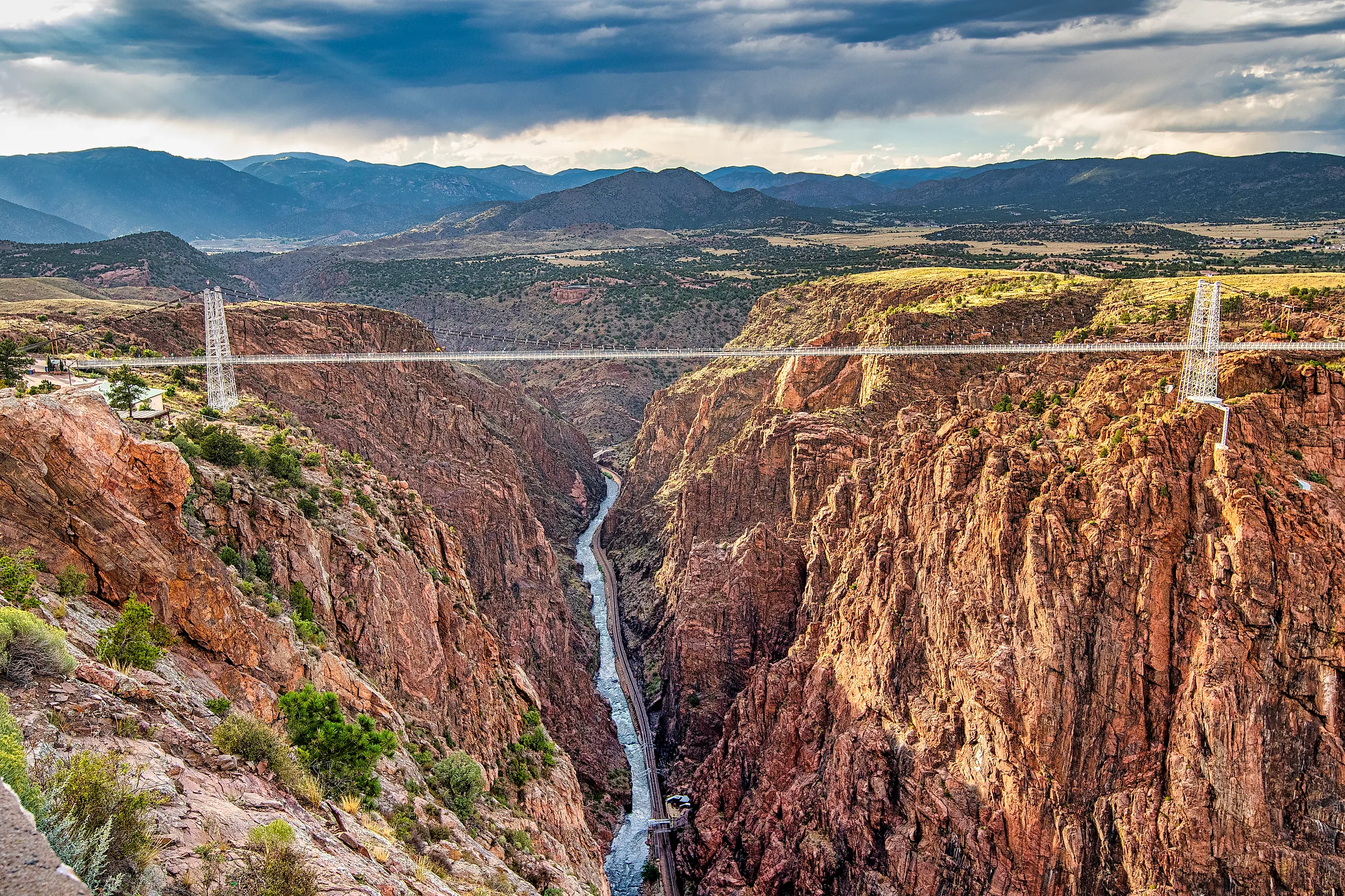
The highest, Colorado's Royal Gorge Bridge, hangs 956 feet above the Arkansas River, about three and a half times the Golden Gate's height. Most of the others cross western gorges so deep that a road built at the rim ends up hundreds of feet over the river. At one of them, in Idaho, BASE jumping off the deck is legal every day of the year.
Royal Gorge Bridge, Colorado: 956 Feet

Outside Cañon City, the Royal Gorge Bridge hangs 956 feet above the Arkansas River. The suspension bridge opened in 1929 and held the world record for the highest bridge until 2001. Cars are barred from the deck, which is open to people on foot, and a park has grown up around the drop.
The only way to get higher than the deck is the park's aerial gondola, which is included with general admission and crosses the gorge about 1,200 feet above the river. From the cabin, the bridge sits below the riders, with the river much farther down. The other rides use the same empty space. The Cloudscraper Zip Line runs from rim to rim, the Royal Rush Skycoaster swings riders out over the gorge, and a via ferrata course climbs the granite walls.
Rafting outfitters run Class IV rapids through the gorge below the bridge, and the Royal Gorge Route Railroad follows the river along the bottom, passing directly under the deck.
Mike O'Callaghan-Pat Tillman Memorial Bridge, Nevada and Arizona: About 900 Feet

On the Colorado River just below Hoover Dam, the best view from the Mike O'Callaghan-Pat Tillman Memorial Bridge goes to people who park and walk. A parking area on the Nevada side leads to a plaza and a pedestrian walkway along the 2,000-foot bridge. From the walkway, Hoover Dam sits about 1,500 feet upstream in Black Canyon, with the river about 900 feet below.
Drivers miss that view, because the bridge's sidewalls are too high to see the dam from a car. The bridge opened in 2010 as the Hoover Dam bypass, carrying Interstate 11 and US 93 straight across Black Canyon, and the arch that holds the road at that height is concrete.
New River Gorge Bridge, West Virginia: 876 Feet

Far from the western canyons, West Virginia's New River Gorge Bridge draws its biggest crowd on the third Saturday of October, when Bridge Day opens the span to an event built on its height. BASE jumpers step off the deck 876 feet above the New River and open their parachutes over the gorge, while rappellers lower themselves toward the water on ropes. The bridge crosses the gorge on a 1,700-foot steel arch inside New River Gorge National Park and Preserve.
The rest of the year, paved sidewalks and a wooden walkway at the Canyon Rim Visitor Center lead to overlooks facing the arch, and BridgeWalk takes groups out onto the structure itself. Its guided walks follow a maintenance catwalk 25 feet below the road and 851 feet above the river, last more than two hours, and started at $79 per person in 2026. The catwalk runs the full 3,030-foot length of the bridge, with traffic passing overhead on a deck the company describes as a 69-foot-wide umbrella.
Foresthill Bridge, California: 730 Feet

The Foresthill Bridge was built for a lake that never filled. When it opened near Auburn in 1973, the plan was for the Auburn Dam to flood the North Fork American River, so the road had to be carried high above the future waterline. The dam was never built, and the bridge, the highest in California, still stands 730 feet over a river canyon.
A walkway runs the length of the bridge, a little under half a mile end to end, with views up and down the American River. Down in the canyon, in Auburn State Recreation Area, the Lake Clementine Trail starts near the Confluence and follows the North Fork upstream to North Fork Dam, where water spills over the curved face when flows are high enough.
Rio Grande Gorge Bridge, New Mexico: About 600 Feet

About 12 miles northwest of Taos Plaza, US 64 runs across the flat Taos Plateau with little sign of the river until the road reaches the Rio Grande Gorge Bridge. The Rio Grande has cut a gorge up to 800 feet deep into the plateau, and the 1,272-foot bridge crosses it about 600 feet above the water. This stretch of river is part of the Taos Box, a whitewater run that passes under the bridge and that the Bureau of Land Management says requires expert boating skills.
Sidewalks rebuilt in 2012 line the bridge, and parking areas at either end let people stop and walk out over the gorge. On the west side, a rest area run by the New Mexico Department of Transportation has picnic shelters, water, and restrooms. From its parking lot, a flat trail heads out along the rim of the gorge.
Perrine Bridge, Idaho: 486 Feet

BASE jumping is legal year-round at the Perrine Bridge, one of the few bridges in the country where that is true. The bridge carries US 93 into Twin Falls 486 feet above the Snake River, and jumpers fall from the deck toward the river before their canopies open. People walking the rim nearby may catch one drifting down into the canyon.
The Twin Falls Visitor Center sits next to the bridge, rents bikes, and connects to more than 10 miles of developed trails along the canyon rim. Farther along, the trail passes above Pillar Falls in the river below and reaches Evel Knievel's jump site about 3 miles from the visitor center.
Navajo Bridge, Arizona: 467 And 470 Feet

For 750 miles of the Colorado River, there are only seven land crossings, and Navajo Bridge, where two spans stand side by side over Marble Canyon, is one of them. Early morning is the best time to look for California condors here. Birds from the flock released at nearby Vermilion Cliffs National Monument often roost on the bridge and ride the wind that moves through the canyon.
Later in the day, the older span is the place to walk. It opened in 1929, 467 feet above the river, as the highest steel arch bridge in the world, and it became a footbridge after a second bridge, 470 feet up, took over the traffic in 1995. The Navajo Bridge Interpretive Center, open year-round, has displays inside and out on the deck. About 5 miles upstream at Lees Ferry, river runners launch their boats at the start of the Grand Canyon.
Crooked River High Bridge, Oregon: 295 Feet

At Peter Skene Ogden State Scenic Viewpoint in central Oregon, three bridges cross the Crooked River's canyon within sight of each other. The oldest is a railroad bridge from 1911. The Crooked River High Bridge followed in 1926, with its deck 295 feet above the canyon floor, about 25 feet higher than the Golden Gate's roadway sits above the bay, and it carried US 97 until 2000. That year, the Rex T. Barber Veterans Memorial Bridge took over the highway, and the 1926 bridge was turned over to people on foot. With the railroad bridge farther along the canyon, a walk across the 1926 deck puts visitors at nearly the same height as the cars on the newer bridge next door.
Two of these heights were set by water that had to be cleared. The Golden Gate's deck was set to leave room for the ships passing between the Pacific and San Francisco Bay, and the Foresthill Bridge was raised for a reservoir behind Auburn Dam. Everywhere else, the deck sits where it does because a river cut the land away first: the Arkansas through the Royal Gorge, the Colorado through Black Canyon and Marble Canyon, the Snake at Twin Falls. Three of these bridges, Crooked River, Royal Gorge, and Navajo, were finished before the Golden Gate opened in 1937, at heights set by the canyons they crossed. The difference is clearest at Foresthill, where the walkway still runs 730 feet above the North Fork American River, high over the waterline of a lake that never filled.