9 Most Scenic Drives in New England
Whether you are looking to escape big city life in Boston for a while or are visiting New England for the first time (presumably hungry to see all this beautiful corner of the United States has to offer), there are so many ways to explore this distinct region. For those who prefer not to travel entirely on foot or by bicycle, there is an extensive network of highways within New England to appreciate, many of which are officially recognized as scenic byways.
Read on to see what makes nine of these roadways so special, from the most popular viewpoints along them to notable historic landmarks, and the cozy communities dotted along the way for you to discover.
Mohawk Trail, Massachusetts

Stretching roughly 69 miles from Greenfield to Williamstown, the Mohawk Trail is one of New England’s oldest scenic routes and a perfect showcase of western Massachusetts’ mountainous geography and heritage.
Following an ancient Native American trade route through the Berkshires, the route passes through hardwood forests (especially gorgeous in the fall), river valleys, and mountain overlooks. Travelers often stop at the Hairpin Turn in North Adams for sweeping views of the Hoosac Range or explore the Bridge of Flowers in Shelburne Falls, where a seasonally open museum accompanies a retired trolley bridge. True outdoor enthusiasts can also hike sections of Mohawk Trail State Forest, visit nearby Natural Bridge State Park, known for its naturally formed white marble arch, or climb the Whitcomb Summit to see the "Hail to the Sunrise" statue at the trail’s highest point.

Other, more culturally oriented stops include the Massachusetts Museum of Contemporary Art (MASS MoCA) in North Adams. But regardless of what you choose to do on the way, this byway combines an eclectic mix of nature, art, and small-town culture, appealing to almost all interests in a single, highly navigable drive.
Route 100, Vermont

Running nearly the entire length of the state of Vermont, Route 100 is often called the state’s most scenic highway. It primarily winds through the Green Mountains for approximately 216 miles, linking numerous towns, historic villages, and outdoor landmarks.
Most notably, the highway passes through renowned locations like Stowe, Waitsfield, and Ludlow, each bringing something local and unique to the table, whether it's a classic general store, local breweries, or covered bridges, and connects to major ski areas like Killington, Sugarbush, and Mount Snow. In winter, the route connects several more of Vermont’s major ski areas, as well, including Killington, Sugarbush, and Mount Snow.

Like most of Vermont, nature is always close at hand on Route 100, with spots like Waterbury Reservoir, Moss Glen Falls, and Green Mountain National Forest providing easy access to hiking, camping, swimming, and more. The stretch between Weston and Stowe is especially noted for its autumn foliage, with roadside farmstands and sugarhouses often open, depending on the season.
Schoodic National Scenic Byway, Maine

The Schoodic National Scenic Byway covers about 29 miles of road along Maine’s coastal Route 1 and Route 186. It mainly circles the Schoodic Peninsula, home to a quieter, less-traveled section of Acadia National Park on the mainland. The drive begins near Hancock and follows the shoreline through Winter Harbor and Prospect Harbor, where you'll come across a selection of quaint fishing villages, working docks, and views of Cadillac Mountain across Frenchman Bay.
Within Acadia’s Schoodic District, the loop road leads to Schoodic Point, a dramatic headland where waves crash against majestic granite ledges. And suppose you would like to learn more about the area during your next visit. In that case, the nearby Schoodic Institute is a great option, offering exhibits on coastal ecology and local history.

Between stops, be sure to keep an eye out for various local art galleries, seafood shacks, and other small-town landmarks, such as the Prospect Harbor Lighthouse. Moreover, pullouts along this nationally recognized byway often feature interpretive signage and access to a plethora of hiking and cycling routes.
Although short, the Schoodic is among the greatest coastal drives in the United States, and certainly in Maine. However, if you're willing to drive longer, another worthwhile route, practically adjacent to the Schoodic National Scenic Byway, is the Acadia All-American Road. This journey focuses more on Acadia National Park, looping much of Mount Desert Island.
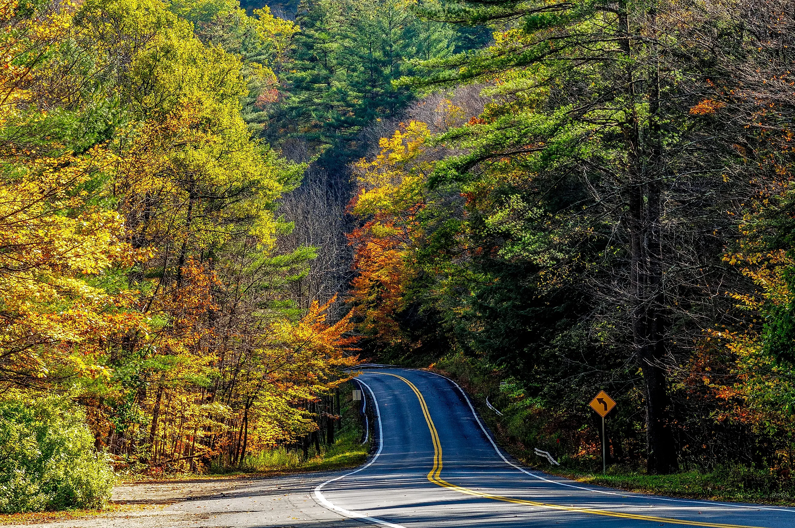
Kancamagus Highway, New Hampshire

The Kancamagus Highway, or “the Kanc,” runs 34.5 miles through the highly picturesque White Mountain National Forest, starting at the town of Conway and ending roughly near Lincoln along Route 112. Best known for its mountain scenery and lack of commercial development, the highway climbs nearly 3,000 feet to Kancamagus Pass, where numerous overlooks offer stunning views of the Swift River Valley and distant peaks beyond.
It is recommended to visit natural landmarks like Sabbaday Falls, Rocky Gorge, or Lower Falls, each accessible by short, well-marked trails that are easily reached from the byway. Take a look at the Russell-Colbath Historic Site as well, which offers a glimpse into 19th-century frontier life in this wild and rugged portion of the state.

During autumn, the route becomes one of the most photographed foliage drives in all of New England, and it can get quite a bit more crowded. Its numerous hiking trails and swimming holes make it appealing year-round, whether you need to cool off on a hot summer day or are breaking out the snowshoes after the first winter snowfall.
With few gas stations or restaurants along its length, the Kancamagus Highway remains among New England’s most pristine and self-contained scenic routes, one to take if you genuinely wish to escape city life for a while.
Merritt Parkway, Connecticut

Opened in 1938, the Merritt Parkway is both a functional highway and an enduring piece of American roadway history. Running 37 miles through Fairfield County from Greenwich to Milford, it was actually built as one of the nation’s first scenic limited-access roads.
It is perhaps most renowned for its 69 bridges, each featuring a distinct architectural style, ranging from Art Deco to Gothic Revival, which lends the route a museum-like quality. Furthermore, the parkway is lined with stands of mature oaks and maples that form a green tunnel through Connecticut’s southwestern hills, making it yet another route that is particularly striking in autumn.

Between the bridges and woodlands, make a point of stopping in nearby towns such as Westport, New Canaan, and Fairfield to check out a variety of museums, urban green spaces, and historic districts. The Stamford Museum & Nature Center and the Glass House in New Canaan, for example, are standout detours. Wherever you decide to go on this inland drive, it'll surely give you a new perspective on Connecticut, which many consider to be one of America's most overlooked states.
Revolutionary Heritage Byway, Rhode Island

The Revolutionary Heritage Byway traces Rhode Island’s role in the American Revolution through a straightforward, 6-mile route connecting the towns of Bristol and Warren. The drive follows a section of historic Route 114, passing numerous colonial-era homesteads, waterfront wharves, preserved forts/battle sites, and other interesting history-filled landmarks.
Beginning on the southern point of Bristol at the Mount Hope Bridge, travelers can visit Linden Place, an 1810 Federal-style mansion with longstanding ties to maritime trade, or walk along Hope Street lined with even more aged 18th-century buildings. The road then continues north through Warren (which rests just 20 minutes east of Providence), home to the Maxwell House, one of the state’s oldest residences, and the Haffenreffer Museum, which further highlights Rhode Island’s early industries.

If you would like to continue another 10 miles on to East Providence, the route nears the site of the 1778 Battle of Rhode Island on Aquidneck Island, commemorated at Butts Hill Fort. With all that, the Revolutionary Heritage Byway is a top choice for history buffs, blending scenic waterfronts with a vast collection of well-preserved landmarks from the country's earliest days.
Molly Stark Trail, Vermont

Spanning the entirety of southern Vermont, from Brattleboro to Bennington, the 48-mile Molly Stark Trail follows Route 9 through the Green Mountains and several historic communities tied to history dating back to the American Revolution. The route takes its name from Molly Stark, the wife of General John Stark, whose militia played a crucial role in securing victory at the Battle of Bennington in 1777.
Today, this scenic byway passes by a plethora of man-made and natural landmarks across Windham and Bennington Counties. In Brattleboro, feel free to explore the Brattleboro Museum & Art Center or shop/sightsee along the busy Main Street. The road later ascends Hogback Mountain, where an overlook provides some of the best long-distance views in southern Vermont.

In Wilmington, numerous small, locally run galleries and mom-and-pop eateries cluster near Lake Whitingham, a popular spot for boating and fishing. Lastly, the drive ends in Bennington, home to the Bennington Battle Monument and Old First Church, two more worthwhile locales that offer a glimpse into the settlement of this part of New England.
Old King’s Highway, Massachusetts

Also known as Route 6A, the Old King’s Highway follows Cape Cod’s northern edge, visiting lots of fishing communities and other wonderful coastal scenery. Ranging approximately 62 miles from Bourne to Provincetown, it traces another one of the oldest travel routes in the United States, originally used by early settlers in the 1600s.
Passing through some of Cape Cod’s most historic towns, namely Sandwich, Barnstable, Yarmouth Port, and Brewster, this must-see scenic roadway is filled with old-timey homes, small museums, and delicious seafood joints all along the way. For one, in Sandwich, the Heritage Museums & Gardens display a wonderful array of regional art and horticultural collections. At the same time, Barnstable hosts the Sturgis Library, one of the oldest of its kind in the country. Beyond Orleans, the landscape opens to sand dunes, wetlands, and beaches within Cape Cod National Seashore.

Scenic detours peppered throughout the byway lead to spots such as Nauset Light and the tidal flats in Brewster. With its abundant, colonial architecture and Atlantic views, whichever path you take on the Old King’s Highway will guarantee you a slice of American history, classic maritime culture, and natural beauty on one continuous oceanside journey.
Lakes Region Tour, New Hampshire

The Lakes Region Tour is situated in the heart of New Hampshire, centered on Lake Winnipesaukee and its neighboring bodies of water, including Squam Lake, Newfound Lake, and Lake Winnisquam, as well as numerous other ponds, rivers, and streams. This extensive route spans approximately 111 miles in total, connecting communities such as Laconia, Meredith, Center Harbor, and Wolfeboro, the latter of which is often referred to as the oldest summer resort town in America.
Along the way, it's impossible not to encounter at least a few waterfront promenades, marinas, and idyllic mountain viewpoints. Spend some time in one or more towns as well, with Meredith's compact downtown core housing useful amenities like shops, restaurants, and the Winnipesaukee Scenic Railroad, which runs vintage train rides along the lake’s edge.

Moreover, at Weirs Beach in Laconia, you will find a selection of lakeside boardwalk amusements and be able to access the historic M/S Mount Washington cruise ship. Nearby, Squam Lake also offers a quieter detour for kayaking, canoeing, and wildlife photography, with the Squam Lakes Natural Science Center providing educational trails and local tips before you head out.
The highly varied Lakes Region Tour takes the incredibly beautiful mountain backdrops of central New Hampshire. It pairs them perfectly with a number of relaxing resorts and accessible recreation for the whole family, making it perhaps New England's best gems for visitors and residents alike planning their next summer vacation.
These scenic drives in New England effectively showcase the region’s geography and storied history through roads that link coastlines, parklands, and towns dating back long before the founding of the United States. From the mountain passes of Vermont to the shoreline routes of Maine and Massachusetts, each of these nine special byways presents its own unique blend of local culture and diverse landscapes, rewarding travelers who take the time to slow down and experience the journey.