10 Most Scenic Drives in Ohio
Ohio does not advertise itself with mountain passes or coastal cliffs. What it offers instead is contrast across short distances. A glacier stopped partway across the state and left flat till plains on one side and an unglaciated, deeply cut plateau on the other. Rivers carved sandstone gorges in the southeast, canal builders trenched the western farmland in the 1820s, and the Ohio River shaped 452 miles of the southern border.
The Ohio Department of Transportation (ODOT) manages more than two dozen designated scenic byways that trace these landscapes. Ten of them stand out. Working clockwise around the state, they begin with the canal towns of the northeast, run down through Appalachian coal country and along the Ohio River, then west across the farm counties and back to the prairie remnants outside Columbus.
Ohio & Erie Canalway

The Ohio & Erie Canalway runs 110 miles from Cleveland to New Philadelphia, with a spur connecting Massillon and Canton. It has no single highway number, instead stitching together state routes, county roads, and city streets, so drivers follow the byway signs rather than one shield. The route earned National Byway designation in 2000 and sits within the Ohio & Erie Canalway National Heritage Area.
This drive covers the widest range of landscapes in the state. The route leaves industrial Cleveland, drops into the Cuyahoga River valley, and comes out in Tuscarawas County farmland. Wherever possible, it traces the old canal alignment, so the Towpath Trail and the Cuyahoga Valley Scenic Railroad stay close for much of the way.
North of Cuyahoga Valley National Park, there are three approaches out of the city. A western line through the historic neighborhoods of Ohio City and Tremont, a central line through the industrial flats, or an eastern line through the Warehouse District. All three converge on Riverview Road, which runs the length of the national park along the river. Deep Lock Quarry Metro Park in Peninsula holds the deepest lock on the canal, and Hale Farm & Village in Bath operates as a living-history museum.
South of Akron the route strings together canal towns including Barberton, Canal Fulton, Massillon, Navarre, Bolivar, Zoar, Dover, and New Philadelphia. Zoar, settled by German Separatists in 1817 who built seven miles of the canal themselves, is now a National Historic Landmark.
Allow a full day for the drive. Urban traffic through Cleveland and Akron is the main bottleneck, and the national park section fills on summer weekends. Because the byway uses local streets, a downloaded map beats a phone signal in the valley.
Appalachian Byway of Ohio

The Appalachian Byway of Ohio follows State Route 78 (SR 78) for about 105 miles, running east to west from Clarington on the Ohio River to Nelsonville. ODOT approved the route in September 2019 as a renaming and expansion of the older Morgan County Scenic Byway, extending it across four counties. At its eastern end, the byway connects with the Ohio River Scenic Byway at the Hannibal Locks and Dam on SR 7. A signed spur also runs north on SR 83 to The Wilds at Cumberland in Muskingum County, then returns south on SR 284 to rejoin the main route.
This drive is the closest Ohio comes to a true mountain road. SR 78 climbs onto the ridge tops of the unglaciated Allegheny Plateau and stays there, dropping into hollows and climbing back out in a rhythm that repeats for miles. The stretch along the south side of Burr Oak State Park in Morgan County is known locally as the "Rim of the World" for its extreme curves and long views, and motorcyclists ride it as part of Ohio's Windy 9 routes.
Heading west from Clarington, the road tightens and passes Woodsfield, the Monroe County seat. Wolf Run State Park offers the first substantial water views and a natural place to stop. Farther west, the Big Muskie Bucket at Jesse Owens State Park preserves the only remaining piece of the largest dragline ever built, a reminder that this ridge country was strip-mined within living memory. McConnelsville is at the middle of the route, and the byway ends at Nelsonville, where the historic public square and the 1879 Stuart's Opera House mark the town's coal-boom era.
Fall delivers the strongest color, and late spring offers the clearest ridge views before full leaf-out closes the sightlines. Services are thin between towns, so fuel in Woodsfield or Caldwell. The pavement is generally good, but the curves are tight and blind, and heavy trucks use this corridor. Drivers coming from central Ohio can join the route from Interstate 77 at Caldwell.
Covered Bridge Scenic Byway

The Covered Bridge Scenic Byway follows SR 26 north from Marietta through the Marietta Unit of Wayne National Forest, then turns onto SR 800 for the last few miles into Woodsfield. The Forest Service lays it out as a 35-mile interpretive tour with 10 marked stops and estimates about four hours to drive it, plus an hour to return to Marietta.
The road holds tight to the Little Muskingum River, mirroring the water's bends rather than cutting across them. Steep wooded hillsides press close on both sides, and the corridor is one of the most remote in the state. Heading north from Marietta, the Hune Bridge appears about 15 miles out. Rolla Merydith built it in 1879, and both the abutment stone and the yellow poplar trusses came from the Hune family farm nearby. Rinard and Hills bridges follow, along with the 19th-century Lamping Homestead site. There are four campgrounds along the route, several of them directly on the river. Graysville marks the last settlement before the road climbs away from the water toward Woodsfield.
Fill the tank in Marietta, because there are effectively no services along the route. Side roads mix concrete and gravel, and the pullouts at some bridges amount to mowed roadside rather than parking lots. The Knowlton Covered Bridge, once the second longest in Ohio, lost its middle span in July 2019 and a second span the following summer, and it has been under reconstruction since. Check its status before building a stop around it. Flood damage has also left some byway signage missing, so carry a map.
Ohio River Scenic Byway

The Ohio River Scenic Byway covers the entire 452-mile length of the river in Ohio, crossing 14 counties from the Indiana state line near Cincinnati to East Liverpool at the Pennsylvania border. It begins on US Route 50 (US 50) at the state line, then follows US 52, SR 7, SR 124, and SR 39 in turn, so the number changes several times and drivers should watch for byway signs. The route carries National Scenic Byway designation and continues west into Indiana and Illinois.
No other Ohio drive holds a single landscape feature for this long. The river stays in view for most of the route, with West Virginia and Kentucky hills rising on the far bank, and the terrain shifts from the broad lower valley near Cincinnati to the steep, narrow cuts of the upper valley above Marietta. Traveling east from Cincinnati, the road passes Ripley and Aberdeen before reaching Portsmouth at the mouth of the Scioto. Gallipolis and Pomeroy break up the middle stretch.
At Marietta, the Campus Martius Museum occupies the site of the 1788 fortification built by the Ohio Company of Associates. Just past town, the route enters Wayne National Forest for a 27-mile run, then continues north through Steubenville on the final leg to East Liverpool. Offshore, the Ohio River Islands National Wildlife Refuge protects 22 islands dotted along the water.
Plan three days at minimum. Spring high water can close some low-lying sections, and fog forms in the valley on cool mornings. Road quality is good throughout, though industrial truck traffic is heavy on the northern end.
Welsh Scenic Byway

The Welsh Scenic Byway makes a 64-mile loop through Gallia and Jackson counties, beginning and ending at Gallipolis. It follows US 35, SR 325, SR 233, and SR 93, and because it is a loop, drivers can run it in either direction.
The loop originates at Gallipolis on the Ohio River, home of Our House Tavern and the Silver Bridge Memorial, and runs northwest on US 35 toward Jackson. At Rio Grande, travelers reach Bob Evans Farms with its Homestead Museum and Log Cabin Village, along with Raccoon Creek, and the University of Rio Grande houses the Madog Center for Welsh Studies.
A southern sub-loop on SR 325 then threads the townships that formed the core of the Welsh settlement, where charcoal iron furnace remains survive in the center of the Hanging Rock Iron Region. Turning west on SR 233, Amish farms appear, and the route passes through Oak Hill, home of the Welsh-American Heritage Museum, before turning north on SR 93 back toward Jackson. Cooper Hollow Wildlife Area is along the corridor.
Fall is the ideal season for this drive. Roads are narrow two-lane routes with limited shoulders and frequent deer. Services concentrate in Gallipolis, Jackson, and Oak Hill.
Hocking Hills Scenic Byway

The Hocking Hills Scenic Byway runs 26.4 miles and begins where SR 374 leaves US 33 near Rockbridge. It is not a point-to-point drive. SR 374 carries the byway southwest through Hocking State Forest, and at the southern end the route makes a loop through the core of Hocking Hills State Park using SR 664 and SR 56 before returning to Rockbridge. Along the way it passes the six non-contiguous sites that make up the state park.
This is the most topographically rugged drive in Ohio. The road threads through Blackhand sandstone gorges where hemlock-shaded ravines hold temperatures cooler than the ridge tops above them, and many of the large pines along the route came from Civilian Conservation Corps plantings in the 1930s.
Leaving Rockbridge, the winding road is popular with motorcyclists and car clubs. Cantwell Cliffs comes first, with deep valley walls, cliffs, and rock shelters, and Rock House follows. Where SR 374 meets SR 664, the loop begins, and drivers can turn in either direction. Turning toward Old Man's Cave leads past Whispering Cave and the John Glenn Astronomy Park to Cedar Falls, one of the most reliable waterfalls in the region. Ash Cave is at the southern end of the loop, the largest recess cave east of the Mississippi River at 700 feet wide and reached by a short paved trail. The Ash Cave Fire Tower, built in 1934, is nearby but is closed to visitors. From South Bloomingville, the byway heads back north to Rockbridge.
October weekends bring heavy congestion and full parking lots. Weekdays and early mornings are more practical, and if Old Man's Cave is full, Cantwell Cliffs and the southern sites almost always have room. Winter ice forms on shaded curves and in the gorges, and the pavement stays damp there long after rain elsewhere has dried. Food and fuel are scarce, with South Bloomingville at the south end and Rockbridge at the north as the best options.
Quaker Heritage Scenic Byway

The Quaker Heritage Scenic Byway makes a 54-mile loop across Clinton and Warren counties, running from Wilmington College to the Clinton County History Center and linking 55 sites along the way. ODOT approved it in 2021, making it the newest byway in the state system. The loop uses paved county and state routes throughout rather than a single numbered highway.
The landscape here is southwest Ohio farm country on gently rolling glacial till, and the appeal is the density of surviving 19th-century built landscape rather than the terrain. Leaving Wilmington, the byway passes the Dover Friends Meetinghouse and Burial Ground just north of town, built in 1845 in a form typical of American Quaker meetinghouse architecture. The northwestern arc runs toward Harveysburg, home to the schoolhouse that ODOT identifies as the first school for free Black children in Ohio. Waynesville marks the far end of the loop, and the return leg crosses the Caesar Creek watershed before closing back at the Clinton County History Center. The route also intersects the Little Miami Scenic Trail and Caesar Creek State Park.
Autumn suits this drive well, and the loop takes a full day with stops. Roads are paved two-lane routes with light traffic, and about a dozen fuel stations sit directly on the corridor. Several of the historic Quaker buildings are now private homes, so view those from the road. Caesar Creek State Park draws boat trailers on summer weekends.
Land of the Cross-Tipped Churches

The Land of the Cross-Tipped Churches covers 38.4 miles through Shelby, Auglaize, and Mercer counties. The route begins at McCartyville, follows SR 119 west to Fort Recovery, then turns north on SR 49 and ends at SR 29 west of Wabash. Additional sites sit off the route in Darke County, Ohio, and Adams County, Indiana.
This byway earns its place through sightlines rather than topography. The farming region is virtually level, and cross-tipped church spires are visible for miles across it. German Catholic immigrants built these structures, and the National Register of Historic Places added them in 1979. Driving west from McCartyville, spires come into view one after another across open ground. The Maria Stein Shrine of the Holy Relics is near the midpoint and functions as the regional anchor. Fort Recovery marks the western turn, after which the route runs north through Mercer County farmland to the endpoint.
Any season works here, and even winter works because bare fields extend the sightlines. Roads are flat, straight, and lightly traveled. Blowing and drifting snow across open farmland is the one weather concern worth planning around. Signage is incomplete westbound in Minster, where the byway turns north.
Miami and Erie Canal Scenic Byway

The Miami and Erie Canal Scenic Byway follows SR 66 for 54 miles through four counties, running north from the Johnston Farm and Indian Agency near Piqua to Delphos. The canal it traces ran 274 miles from Cincinnati to Toledo, and construction lasted from 1825 to 1845.
This is level ground, drained and squared into some of the most productive farmland in the state. The interest lies in reading engineering history from the road, since berms, prisms, and lock walls appear at intervals through the fields, and three lakes that once fed the system sit near the corridor. Northbound from Piqua, the Johnston Farm and Indian Agency offers mule-drawn canal boat rides and sets the historical frame.
The route continues through Lockington, Fort Loramie, and Minster, where it crosses the Land of the Cross-Tipped Churches byway and the two drives can be combined into one long day. New Bremen and St. Marys follow, with Grand Lake St. Marys immediately west of the corridor, and the final stretch runs through Spencerville to Delphos.
Late spring through early fall are best, when the towpath trail sections are open, and roadside stands operate. The road is flat, straight, and easy, with farm equipment as the main traffic consideration. Note that the canal does not stay beside the road for the entire route.
Big Darby Plains Scenic Byway

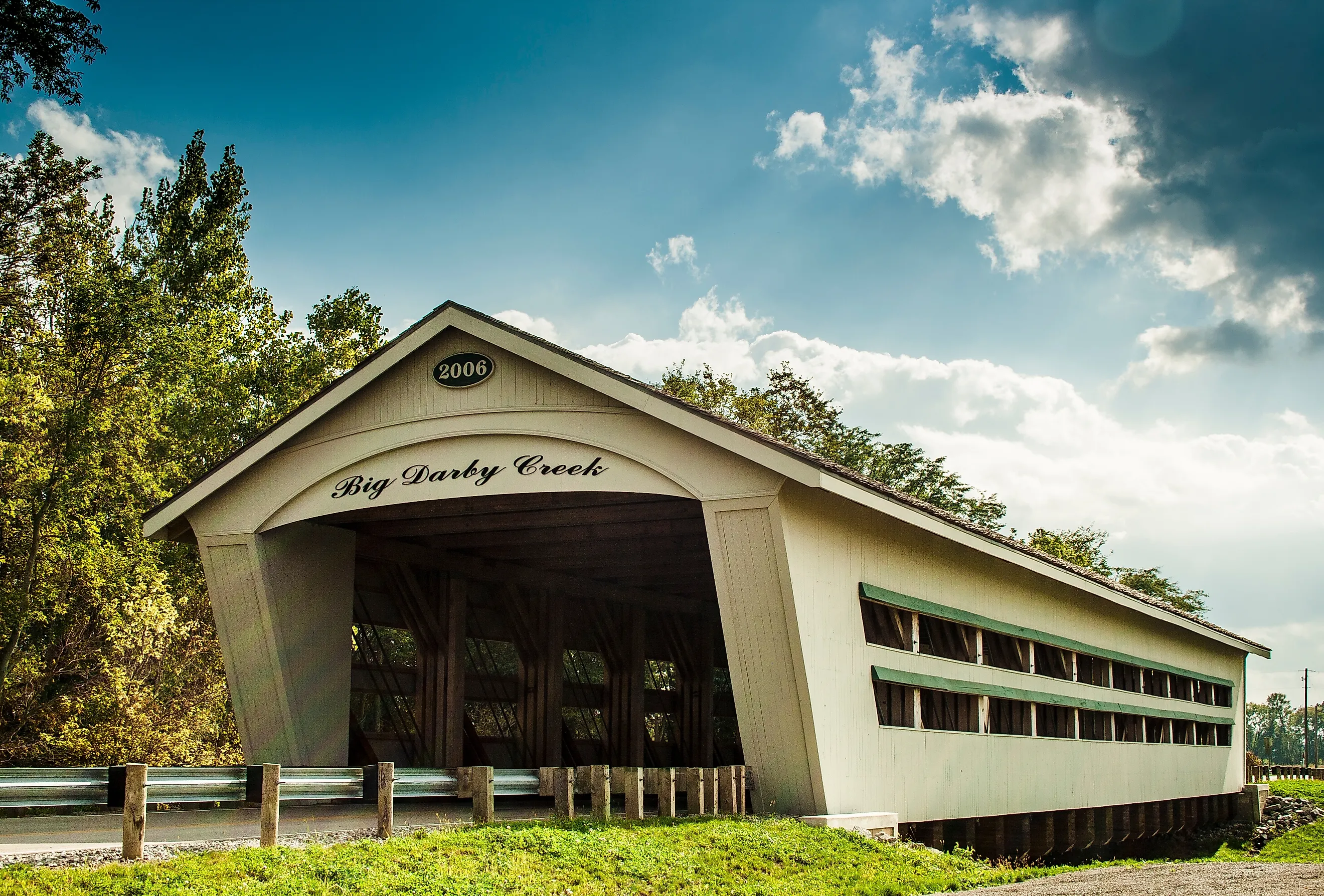
The Big Darby Plains Scenic Byway runs about 27 miles through Union, Champaign, and Madison counties, following county and state routes that include a stretch of SR 161. The main route parallels Big Darby Creek, a state and national scenic river, and passes through Milford Center, Unionville Center, and Plain City.
This drive is flat. The Darby Plains held one of Ohio's largest concentrations of native prairie before European settlement in the early 1800s, and remnants of it survive in pockets along the corridor. Starting near Plain City and working northwest, the byway crosses and recrosses the Darby watershed through open cropland broken by riparian timber. Smith Cemetery State Nature Preserve and Bigelow Cemetery State Nature Preserve hold tall native prairie grasses and give the clearest surviving look at the pre-settlement landscape. The historic Pottersburg Bridge provides a stopping point with a footbridge and a walking trail across the countryside. The route continues past North Lewisburg and back through the small farm towns that give the byway its rhythm.
Late June through early August brings the prairie preserves into bloom, which is the reason to drive this one in summer rather than fall. Roads are two-lane and well maintained, though agricultural equipment shares them during planting and harvest. Traffic increases near Plain City and on the eastern approaches toward Dublin.
Planning Your Drive
Ohio's best scenic drives are less about one knockout view and more about what builds up along the way. Covered bridges appear every few miles above Marietta, church spires rise across the Mercer County fields, and the Ohio River stays beside the road for 452 miles. These ten byways make their case mile by mile.
Season matters more in Ohio than in states with scenery all year. October brings the best color to the southeastern routes, though Hocking Hills gets crowded on fall weekends. Summer is prime time for the blooming Darby Plains. Winter opens wider views across the Cross-Tipped Churches corridor once the leaves are gone.
Two practical tips apply to most routes. Fill up before long stretches without services, and use ODOT's maps since several byways follow local roads instead of one highway. Give the drive a full day and let the stops build naturally.