5 National & State Parks In Washington You Have To Visit
Washington State is home to some of the most attractive and interesting scenery in the Pacific Northwest. For those of us who enjoy exploring Mother Nature's rich bounty, these diverse environments have been preserved in an impressive collection of national and state parks that attract millions of visitors each year. While Washington's three national parks protect some of North America's most dramatic mountain wilderness, the state park system encompasses coastal headlands, island shorelines, and desert canyons besides. Together, this abundance of public lands adds up to a playground for outdoor enthusiasts that rivals anywhere else in the country. Whatever your pleasure, Washington's parks deliver experiences accessible to casual day-trippers and serious backcountry adventurers alike.
Olympic National Park

Covering nearly a million acres on the Olympic Peninsula, Olympic National Park protects one of the most diverse ecosystems in North America. The park includes three distinct environments: glacier-capped mountains, 73 miles of Pacific coastline, and the Hoh Rainforest. One of the world's best examples of temperate rainforest, here you will thrill at the sight of massive Sitka spruce and western hemlock draped in moss, the tallest approaching 300 feet and some of them a thousand years old.

The Olympic Mountains dominate the park's interior, with Mount Olympus topping out at 7,980 feet. Despite that modest elevation, the peak catches enough Pacific snowfall to carry the largest glacial system in the Olympic Range. Rivers radiate from these summits in every direction, among them the Elwha, whose salmon runs have been rebounding since the removal of two dams there. Head to Hurricane Ridge, reached by a 17-mile mountain road from Port Angeles, for wide views over the range and a choice of trailheads.

The park's coastal strip runs between Ozette Lake and the Queets River, with sea stacks, tide pools, and beaches scattered with driftwood logs. Ruby Beach and Rialto Beach are the most photographed, with their offshore rock formations. Plan around the tide tables rather than the clock; several stretches are only passable at low water.
When to visit: June through September is best for warm weather, though coastal areas remain accessible year-round.
Mount Rainier National Park

At 14,410 feet, Mount Rainier is the most prominent mountain in the Lower 48, rising higher above its surroundings than any other peak in the contiguous states. It carries 26 major glaciers, and one of them, the Emmons, covers more ground than any other glacier in the continental United States, running about 4.5 miles down the mountain's northeast flank. Rainier last erupted roughly 1,000 years ago and remains an active volcano, with geothermal heat maintaining ice caves inside the summit crater.

Paradise, on the mountain's south slope, is one of the snowiest places on the planet and holds a seasonal record of 1,122 inches set in the winter of 1971 to 1972. The Paradise Inn, built in 1916 from Alaska yellow cedar logs and now a National Historic Landmark, makes a base for the Skyline Trail, which climbs through subalpine meadows that fill with avalanche lilies and lupine each summer.

The Wonderland Trail circles the entire mountain over 93 miles, passing through valleys, old-growth forest, and alpine zones while crossing a long series of glacier-fed rivers. Most through-hikers take ten days to two weeks. Sunrise, at 6,400 feet, is the highest point in the park you can reach by vehicle, and on a clear day it delivers views of several volcanic peaks, Mount St. Helens and Oregon's Mount Hood among them. For route planning, see our guide to hiking Mount Rainier.
When to visit: July through September is best for wildflowers and hiking, while winter brings excellent snowshoeing and cross-country skiing.
North Cascades National Park

North Cascades National Park holds some of the most rugged mountain terrain in North America, which is how it earned the nickname the American Alps. More than 300 glaciers sit within its boundaries, roughly a third of all the glaciers in the Lower 48, and they feed the park's waterfalls and turquoise lakes. The jagged summits include 9,131-foot Mount Shuksan, one of the most photographed mountains on the continent.

The park also anchors the only grizzly bear recovery zone on the West Coast, though you will not see one. The last confirmed grizzly sighting in the US portion of the North Cascades was in 1996, and the National Park Service reports no verified evidence since. In 2024 federal agencies approved a plan to restore the species here by moving bears in from the Rockies or interior British Columbia, a translocation that has not yet been scheduled. Black bears, mountain goats, and a resident wolf pack are all still very much present.

The North Cascades Highway is the main route through, with viewpoints at Diablo Lake Overlook and Washington Pass. Reachable only by boat, trail, or floatplane, the Ross Lake National Recreation Area runs up to the Canadian border and holds Ross Lake Resort, a set of cabins built on log floats. The trail system ranges from the wheelchair-accessible Sterling Munro boardwalk to the demanding Cascade Pass Trail, which follows a route Indigenous peoples used to cross these mountains for centuries. In the Stehekin Valley, also boat-and-floatplane access only, the Stehekin Pastry Company bakes two miles up from the boat landing and Rainbow Falls drops more than 300 feet just off the valley road.
When to visit: July through September, when the North Cascades Highway is fully open and the high country is clear of snow.
Deception Pass State Park

Washington's most-visited state park draws over two million people a year to the shores of Whidbey and Fidalgo islands, and it takes its name from the treacherous strait between them, where tidal currents run hard enough to stand the water up in visible rips. The Deception Pass Bridge, completed in 1935, spans 1,487 feet about 180 feet above that water and is listed on the National Register of Historic Places.

Beyond its 14 miles of saltwater shoreline, the park has 6.5 miles of freshwater shore on Cranberry, Pass, and Campbell lakes. Bowman Bay, long a Samish fishing ground, now launches kayakers, while Rosario Beach holds tide pools with purple sea urchins, ochre sea stars, and giant green anemones. Stone kitchen shelters built by Depression-era crews in the 1930s still serve as picnic spots.

The park is no slouch for hiking either. Its 38 miles of trails run from the easy Sand Dune Trail through coastal forest to the steeper Goose Rock Perimeter Trail, which tops out on views across the San Juan Islands to the Olympic Mountains. Anglers should note that Pass Lake is catch-and-release fly fishing only, for cutthroat and rainbow trout, while boggy Cranberry Lake supports carnivorous sundews and Labrador tea.
When to visit: April through October for warmer weather, though winter storms make for dramatic wave-watching.
Palouse Falls State Park

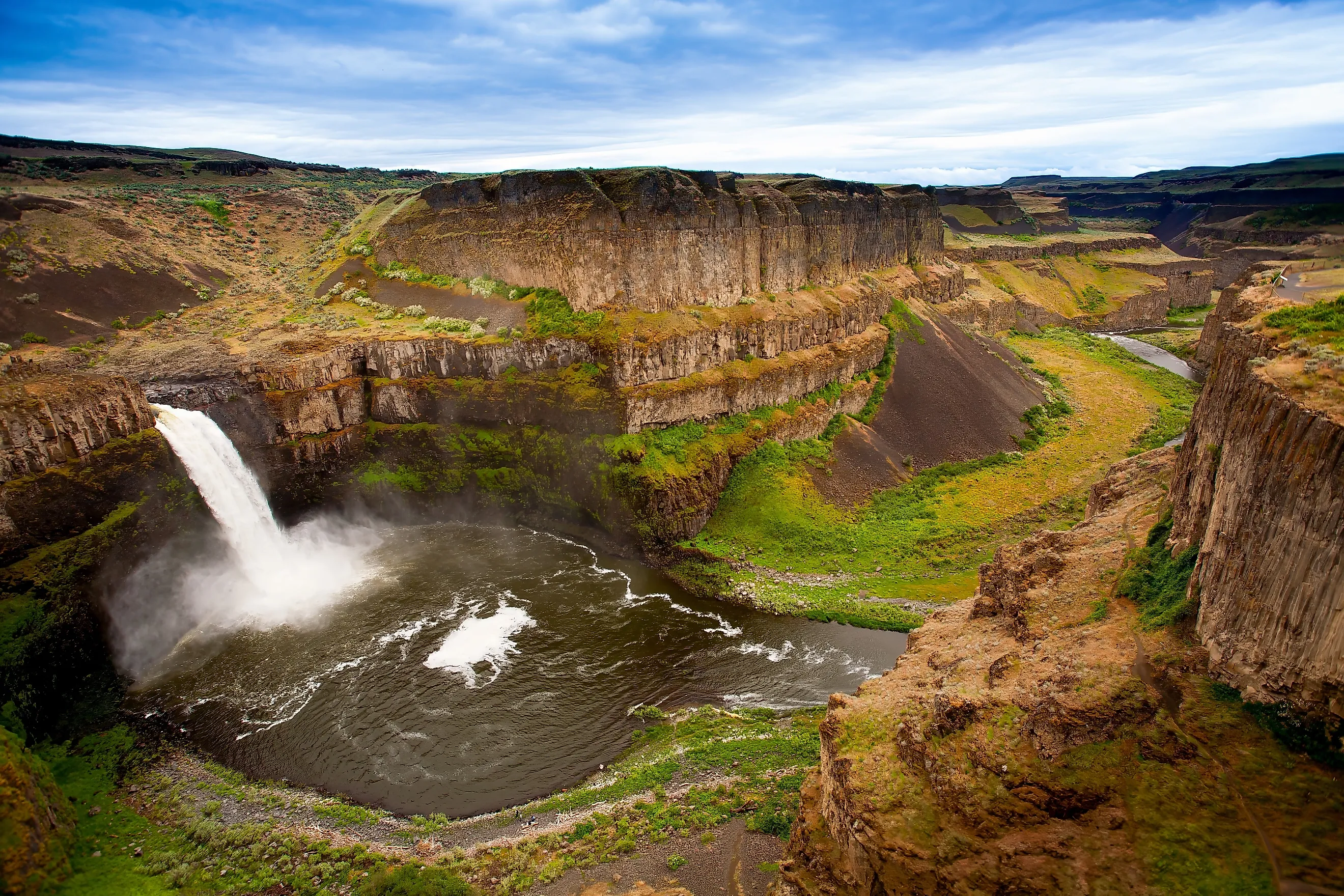
Protecting Washington's official state waterfall, Palouse Falls State Park is where the Palouse River drops 198 feet into a basalt canyon cut by the Missoula Floods around 13,000 years ago. Those floods came when the ice dam holding back Glacial Lake Missoula failed, repeatedly, sending walls of water across eastern Washington and carving the channeled scablands you drive through to get here. The falls originally stood several miles downstream nearer the Snake River confluence and have worked their way upstream as the floods stripped away bedrock.

The canyon walls expose layer on layer of Columbia River Basalt Group lava, some of it around 15 million years old and plainly visible from the overlooks. Spring runoff in March and April sends the river over in volumes you can hear well before you see, and the mist it throws supports moisture-loving plants in a landscape that is otherwise dry shrub-steppe. The plunge pool below reaches about 115 feet deep. The Fryxell Overlook Trail strings together the best viewpoints of both the falls and the canyon.
When to visit: March through May, for peak flow.
Picking Your Park
These five cover a remarkable spread for one state. Olympic gives you rainforest, glaciated peaks, and wild coast inside a single boundary. Rainier is a single mountain big enough to make its own weather. North Cascades is the one for solitude and glaciers, and the one where the ecology is actively being rebuilt. Deception Pass is the easiest to reach and the best value for a day trip. Palouse Falls is the outlier, a desert canyon three hours from anything green, and it explains more about how eastern Washington got its shape than any of the others. Whether you are planning a backpacking route or a family afternoon, all five are worth the time.