The Bridges You Can Walk Across From One State To Another
There is a small thrill in walking past a state line marker on a bridge deck and stepping out of one state and into another. Walkers on the Bob Kerrey Pedestrian Bridge can plant one foot in Nebraska and the other in Iowa, 60 feet above the Missouri River. Partway across the Mississippi on the Big River Crossing, freight trains rumble alongside as Tennessee gives way to Arkansas. Six bridges let pedestrians reach that line on foot, and each crossing comes with its own river, its own history, and its own way of marking the border.
Historic Meridian Bridge

The Historic Meridian Bridge spans the Missouri National Recreational River between Yankton, South Dakota, and Cedar County, Nebraska, at about 3,029 feet long. With parking available at both ends of the crossing, pedestrians can walk from Nebraska's riverfront to Riverside Park and the City of Yankton Forest Tract hiking trails in South Dakota. The state line runs down the middle of the river, making it possible to stand in Nebraska and South Dakota at the same time.
Construction on the double-deck vertical-lift bridge began in 1921, and it opened to through traffic in 1924. Both upper and lower levels opened to pedestrians and bicycles in 2011, and both are accessible. Walkers can start on one level and return on the other. It is about a half-mile walk each way, an easy and convenient way to get in steps.
Bob Kerrey Pedestrian Bridge

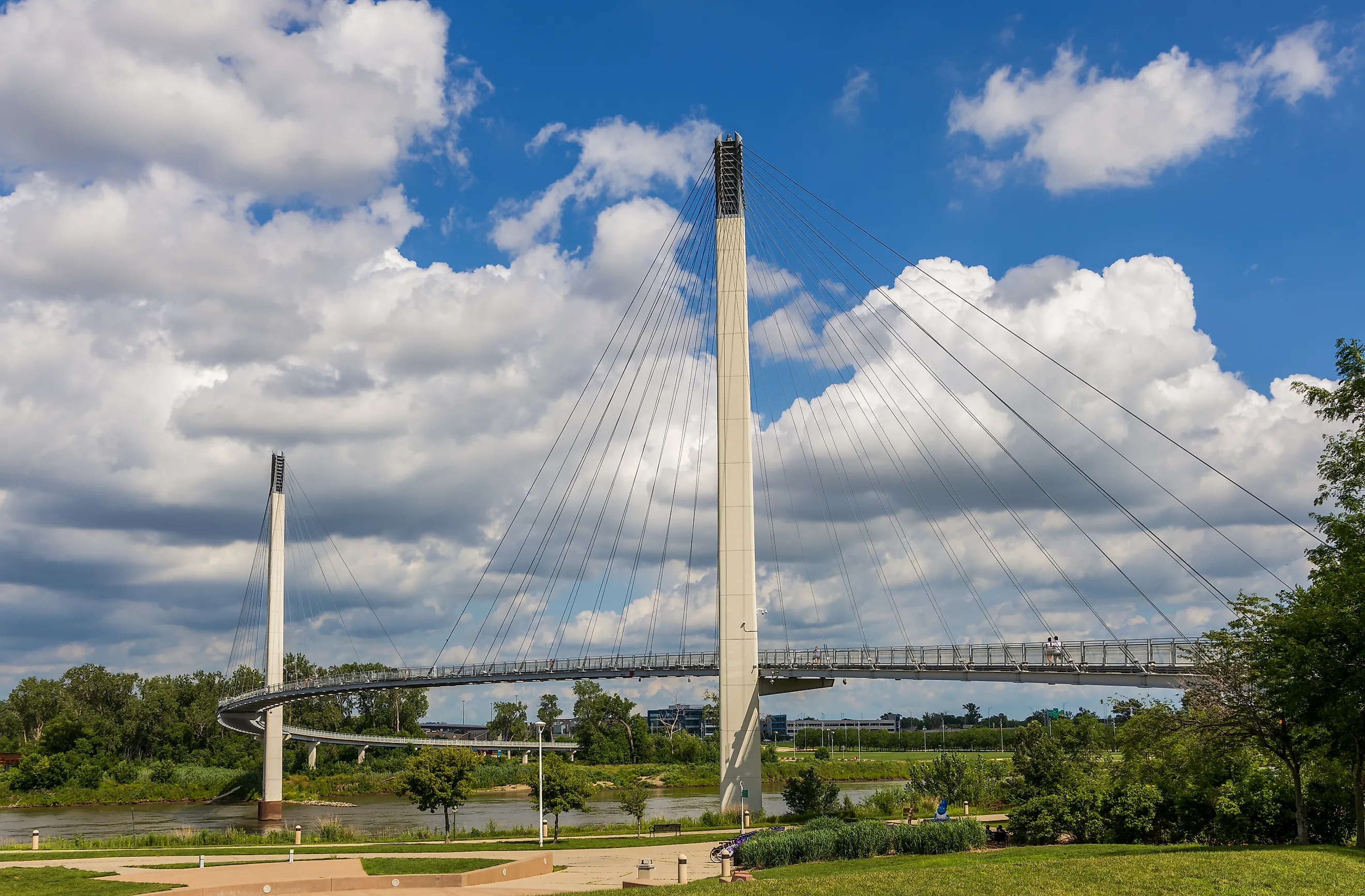
Omaha, Nebraska, and Council Bluffs, Iowa, share the Bob Kerrey Pedestrian Bridge, known locally as Bob the Bridge. Extending 3,000 feet across the Missouri River on a paved path, the cable-stayed bridge has a spot in the middle where walkers stand in two states at once. Pedestrians rise to about 60 feet above the waterway and may feel swaying during windy weather.
On the Nebraska side, the bridge entry is near the Lewis and Clark National Historic Trail Headquarters and Visitor Center, commemorating the region's ties to Lewis and Clark and the Corps of Discovery's Missouri River explorations. At the Iowa end, pedestrians and cyclists disembark near the Tom Hanafan River's Edge Park. Opened in 2008, it is the longest pedestrian bridge linking two states.
Harahan Iron Bridge

Pedestrians can cross the Mississippi River via the Harahan Iron Bridge, a span joining Memphis, Tennessee to West Memphis, Arkansas. Opened in 2016 as the Big River Crossing, it is a mile long in one direction, making it the longest public pedestrian and cyclist bridge across the Mississippi River. A marker indicates where walkers step from Arkansas into Tennessee along the metal and concrete walkway.
The cantilevered bridge opened for rail traffic in 1916 and now serves as a key link to Mississippi River wetlands and supports the area's outdoor recreational needs with a network of parks and gardens on both sides of the span. Union Pacific Railroad still operates on the upper level, and pedestrians can often hear the rumbles and horns of freight trains along the pathway.
The Purple People Bridge

Spanning 2,670 feet across the Ohio River, the Purple People Bridge joins Cincinnati, Ohio, and Newport, Kentucky. True to its name, the steel has been repainted bright purple, and the deck looks out on the river, the downtown Cincinnati skyline, and part of the neighboring John A. Roebling Suspension Bridge. It has two pedestrian walkways, located side-by-side. The wider side is the former vehicle road and the other is narrower. Pedestrians entering along Riverboat Row in Kentucky can walk about three-quarters of the way across before stepping into Ohio, near the Ohio River Trail.
Listed on the National Register of Historic Places, the span opened in 1872 as the Newport and Cincinnati Bridge, where it served as the city's first railway bridge across the Ohio River. It reopened as a pedestrian-only bridge in 2003 and hosts festivals and special events, including fireworks watch parties, along its steel walkway.
The John A. Roebling Suspension Bridge

Farther west on the Ohio River shoreline, the John A. Roebling Suspension Bridge connects Cincinnati, Ohio, and Covington, Kentucky. Crossing the Ohio River along KY 17, the bridge features a steel-grate vehicle deck that produces a distinct "singing" sound from passing traffic, bordered by side-by-side pedestrian walkways offering clear views of the river and passing barges. Boasting a historic 1,057-foot main span, the bridge is open to both vehicles and pedestrians.
Entering along the River Walk in Kentucky, pedestrians walk almost all of the way across before stepping into Ohio and exiting at Smale Riverfront Park. Along the way, visible shoreline landmarks include the Great American Ballpark, home of the Cincinnati Reds, and Paycor Stadium, home of the Cincinnati Bengals, as well as part of the Purple People Bridge upstream.
Designed as an engineering prototype by civil engineer John Roebling, the architect who designed the Brooklyn Bridge, it was the world's longest bridge at the time of its construction in 1866. The bridge is a National Historic Landmark and is designated a National Historic Civil Engineering Landmark by the American Society of Civil Engineers.
Mike O'Callaghan-Pat Tillman Memorial Bridge (Hoover Dam Bypass Bridge)

The Mike O'Callaghan-Pat Tillman Memorial Bridge makes it possible for pedestrians to cross the Colorado River and Black Canyon between Clark County, Nevada, and Mohave County, Arizona. This open spandrel deck arch bridge is one of the highest road bridges in the US, sitting at 890 feet above the Colorado River. At about 1,900 feet in total length, it is the longest single-span concrete arch bridge in the Western Hemisphere. Bridge construction began in 2005, and it opened to traffic in 2010 as part of the Hoover Dam Bypass project.
Separated from vehicle traffic, the paved pedestrian walkway is accessed from the Nevada side, with no entry or exit on the Arizona side. The 1.3-mile round-trip walk runs the full lengeth of the main span and is open to the air, unlike the vehicle portion of the bridge with its tall sides. Pedestrians will experience the normal bridge movements created by weather and traffic, as well as the heat and sun exposure of the desert environment. About three-quarters of the way across, a state line marker designates the border between the two states.
State-Spanning Bridges with Pedestrian Access
Most people cross state lines without giving them much thought, passing a roadside sign at highway speed. On these bridges, pedestrians have time to stop at the boundary, look down at the river separating the states, and continue on foot. Several of the bridges carried trains or vehicles long before they became walking routes, and not every crossing allows pedestrians to exit on the opposite side. Still, all six give people the chance to stand at a state border and cross a line that most only see on a map.