What Actually Separates One Ocean From Another
Sail out of the Gulf of Mexico past the Florida Keys and you enter the Atlantic. Nothing on the water tells you so. That is the strange truth about ocean boundaries. The line dividing one ocean from the next is almost never something a sailor could point at. A rare few are honest geography. At the Bering Strait, one continent stands close enough to watch the calendar change on the other. A handful are water so heavy it behaves like a wall. The rest are lines that mapmakers settled on and everyone else agreed to honor.
Sometimes A Strait So Narrow One Shore Sees The Other

The Bering Strait separates Asia from North America at the closest point the two continents reach. The narrowest crossing measures about 53 miles, and the average depth runs between 98 and 164 feet. Federal ocean researchers describe the strait as the only inlet between the Pacific and the Arctic. Through that bottleneck passes all the comparatively warm and fresh Pacific water that reaches the ice, and no more. The strait also forms the western entrance to the Northwest Passage.
A pair of rocky islands, the Diomede Islands, splits the channel in two. Both channels carry water northward in the annual mean, and the eastern one lies in United States waters. The islands are about 2.4 miles apart. Big Diomede belongs to Russia and has no permanent population, only a weather station. Little Diomede is part of Alaska. The border between the two countries runs between them, and that border coincides with the International Date Line. Anyone on the Alaskan island looks west across 2.4 miles of water at tomorrow.
Sometimes Nothing At All, Whatever A Viral Photo Suggests

The Gulf of Alaska carries a boundary that has circulated online for over a decade, and it does not divide two oceans at all. A photograph taken there in 2007 shows pale blue water meeting dark blue water along a hard, unbroken edge. Captions have claimed for years that the image caught the Atlantic and the Pacific refusing to combine.
Ken Bruland, a professor of ocean sciences at the University of California, Santa Cruz, took the picture during a research cruise studying how iron reaches the open gulf. The pale water is glacial runoff carrying the fine sediment that scientists call glacial flour, poured out by rivers such as the Copper River. The dark water is ordinary seawater. Bruland has said the two do combine, and that the sharp gradient in the photograph is a moment rather than a place. Independent fact-checks have traced the image and reached the same conclusion. Fronts like this one drift and vanish depending on how much sediment the rivers carry.
Sometimes A Chain Of Coordinates No One Can See From A Boat

The Florida Keys run southwest from the mainland, and the official limit of the Gulf of Mexico runs right along them. Limits of Oceans and Seas, the reference book hydrographic offices still use, draws the southeastern boundary as a chain of straight segments. The line joins Cape Catoche Light in Mexico to the light on Cape San Antonio in Cuba, crosses that island to the meridian of 83° W, then turns north. That segment runs north to the latitude of the south point of the Dry Tortugas, at 24°35' N. The line then heads east along that parallel to Rebecca Shoal at 82°35' W. From there it passes through the shoals and the Florida Keys to the mainland at the eastern end of Florida Bay.
In the same reckoning, every narrow stretch of water between the Dry Tortugas and the mainland counts as inside the Gulf. No reef, buoy, or change of color marks the open-water stretches. A crew crossing the 83° W segment leaves the Gulf with no change of any kind visible from the deck.
Sometimes A Strip Of Land, On A Timeline Still Disputed

The Isthmus of Panama is the last ocean-level gap in the Americas to fill in, and it is the one such boundary that nobody had to draw. The strip of land divides the Pacific from the Caribbean Sea, which is a sea of the Atlantic rather than the Atlantic itself. Land does the dividing here, and this boundary is the one scientists argue about most.
The traditional figure holds that the isthmus closed roughly 3 million years ago, a date the field accepted across four decades. Two peer-reviewed studies published in 2015 pushed it much further back. One used zircon grains to date a land connection to about 15 million years ago. The other read molecular divergence in animals on both sides and argued for an early and complex emergence reaching back more than 20 million years. A 2016 review reanalyzed the geological, paleontological, and molecular records and returned to about 2.8 million years. The authors behind both 2015 papers published formal rejections of that review in 2017.
Often A Meridian, Anchored To A Convenient Headland

Cape Agulhas marks the southernmost point on the African continent, about 109 miles southeast of Cape Town. The divider between the Indian and Atlantic oceans is not the cape but the cape's meridian, 20° E. A meridian is a line of longitude, picked here because a recognizable headland is near it. Many people assume the two oceans meet at the Cape of Good Hope, which is better known and further north.
The name Agulhas is Portuguese for needles. One explanation points to the jagged rocks and reefs that have wrecked ships along this coast. Another holds that early Portuguese navigators found their compass needles showing no deviation here, with magnetic north and true north in agreement. The cape stands above the Agulhas Bank, ground that has long been excellent for trawling. The Cape Agulhas Lighthouse went into service in 1849, on a coast whose rocks and reefs had already wrecked many ships.
Often A Bearing On The Compass, Fixed To A Single Rock

Cape Horn rises from Hornos Island at the southern end of the Tierra del Fuego archipelago, in Chile. The 1953 limits book sets the southern boundary between the South Atlantic and the South Pacific at Cape Horn's meridian, 67°16' W. Once again a bearing on the compass draws the boundary, anchored to a single rock. The water it crosses is the Drake Passage, a deep waterway about 600 miles wide. That passage separates Cape Horn from the South Shetland Islands, which lie about 100 miles north of the Antarctic Peninsula. Nothing across the whole width of the Drake Passage marks that meridian.
Cape Horn is often called South America's southernmost point, and it is not. The Diego Ramírez Islands reach further south. The cape marks instead the southernmost headland of the archipelago. Willem Corneliszoon Schouten rounded it in 1616, and the cape took its name from Hoorn, his birthplace. Stormy seas and ice made the rounding a severe test for sailing crews, and the route carried world trade until the Panama Canal opened in 1914.
Sometimes The Shape Of The Seafloor Beneath The Surface

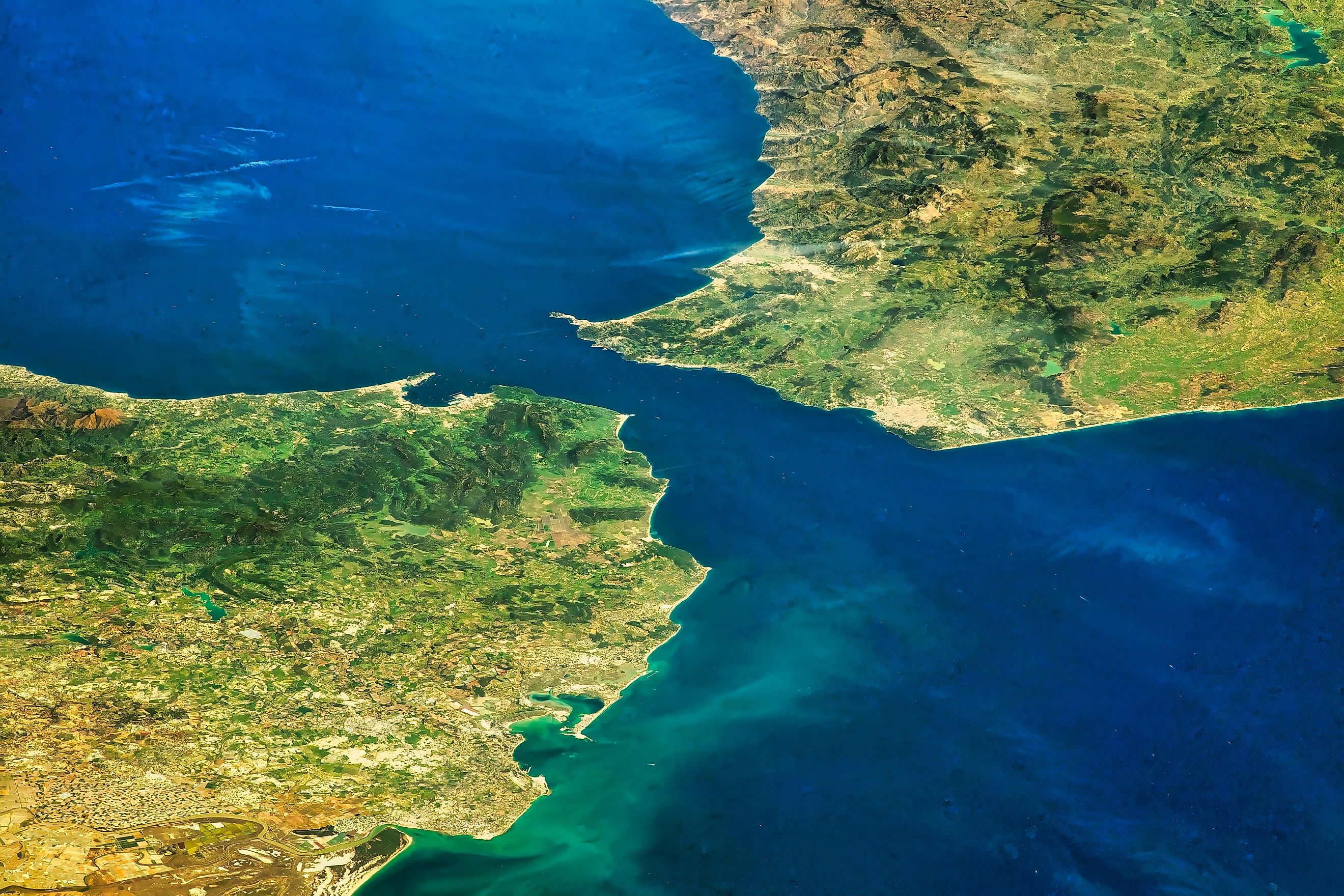
The Strait of Gibraltar narrows to under 10 miles at its tightest. The seafloor here governs what the water does. The strait connects the Mediterranean Sea to the Atlantic across a series of shallow sills. The shallowest of them, the Camarinal Sill, comes within 1,000 feet of the surface, which is shoal water by ocean standards. Evaporation in the Mediterranean basin exceeds what rain and rivers return, so the basin runs saltier and heavier than Atlantic water.
The result is a two-layer exchange. Atlantic water flows east along the surface into the Mediterranean, and dense Mediterranean water flows west underneath it before sinking into the Atlantic. The two layers travel in opposite directions past each other at the same moment. The strait marks a sea meeting an ocean rather than an ocean meeting an ocean. The difference matters, because a sea is not an ocean in any official reckoning. The 1953 revision added the Strait of Gibraltar as an area of its own for the first time.
Rarely, A Moving Front Of Cold Water

The Antarctic Circumpolar Current circles Antarctica with no landmass anywhere to stop it, and it comes closer than any other ocean divider to a boundary made of moving water. Cold polar water meets warmer water to the north along a front that biologists treat as real. The Commission for the Conservation of Antarctic Marine Living Resources defines the Antarctic Convergence in its founding convention. The commission treats that convergence as a biological boundary, even though its latitude shifts by season and by year.
The line the International Hydrographic Organization (IHO) uses is a different one. In 2023 its member states approved a resolution recognizing the Southern Ocean and fixing its northern limit at the parallel of 60° S. Under that resolution, these limits carry "neither political nor oceanographic or, more generally, environmental significance whatsoever," and hydrographic offices may keep their own. The United Kingdom had used 55° S since 1953, five degrees further north, and confirmed with the resolution that its older limit no longer applies. Argentina recorded that it sees no technical grounds for a separate Southern Ocean at all.
Mostly, A Reference Book Written For Mapmakers

Limits of Oceans and Seas remains the document behind most of the world's ocean boundaries, and its third edition dates to 1953. By its own preface, the limits were drawn up for the convenience of national hydrographic offices compiling sailing directions and notices to mariners. The aim was that every publication headed with the name of an ocean would cover the same area. The same preface notes that they are not the result of full geographic study, and that "these limits have no political significance whatsoever." The method is recorded there too. Straits joining two seas were allotted to one of them, and meridians, parallels, and rhumb lines were used as far as possible.
A peer-reviewed effort in 2013 to convert the text into a digital map positioned 709 reference points defining 101 named entities. In 13 cases the authors could not draw the limit at all. One coordinate turned out to be about 3 miles inland. A named cape no longer existed, buried under reclaimed land. A fourth edition was finished in 1986, updated in 2002, and never published, held up by a disagreement among member states over what to call one sea. At its 2026 Assembly in Monaco, the IHO adopted a replacement standard, S-130, which identifies oceans and seas by numerical code rather than by name. Each country may then keep its own name for the same water. The question had been under discussion for more than 50 years.
So What Actually Separates One Ocean From Another

Three of these boundaries are things a person could point at: the gap at the Bering Strait, the land at Panama, and the sills under Gibraltar. One is a moving front of cold water off Antarctica. The rest are meridians and parallels, picked because a headland or a light happened to be near them. The ocean itself is continuous. The divisions are a filing system, and that filing system now runs on numbers.