10 Best Hikes In The Pacific Northwest
The Pacific Northwest, sometimes referred to as Cascadia, is a loosely-defined geographical area of immense beauty. The core constituents are Oregon, Washington, Idaho, and the Canadian province of British Columbia. Some people also include Northern California, Alaska, Western Montana, parts of Wyoming, and the Yukon territory in the mix, but this article will focus (mostly) on the standard four regions. With wild Pacific Ocean coastlines, rugged Rocky Mountain peaks, mixed forests, iconic North American animals, and wholesome, outdoor-loving communities dispersed throughout, this corner of the earth is tailor-made for hiking. The following are ten of the best treks – from short and sweet to long-drawn affairs – in the classic Pacific Northwest region.
Pacific Northwest Trail: Montana, Idaho, Washington

If an on-foot exploration of the Pacific Northwest is what you seek, then the ultimate overview is surely the 1,200-mile, eponymous path. The Pacific Northwest National Scenic Trail (PNT) hugs the Canada-U.S. border as it traverses from Northwestern Montana, through Northern Idaho, and the entirety of Northern Washington, including the Olympic Peninsula – bridging the gap from the Continental Divide to the unspoiled Pacific Coast. Along the way, it also passes through seven mountain ranges, three national parks, and isolated sections of national forests. As a cherry on top, hikers will get to uncover hidden trail towns and cute, waterfront communities. At the risk of dampening anyone's enthusiasm, it is important to come bear prepared. Over 400-miles of the trail traverse grizzly bear territory, and black bears are known to visit the vast majority of the established route.
Pacific Crest Trail (Northern Section): Oregon, Washington

While the PNT gives a horizontal cross-section of the Pacific Northwest, the Pacific Crest National Scenic Trail (PCT) covers the vertical experience for all willing and able thru-hikers. While the 2,650-mile juggernaut route climbs all the way from the Mexico-U.S. border to the doorstep of Western Canada, this 4 - 6 month endeavor can be shortened by skipping over California, and instead focusing on the highlights of Cascadia. The 455.2-mile Oregon portion allows hikers to catch their breath through old-growth forests and beside nourishing lakes – keeping the elevation changes to a minimum compared to South and North. But the people's choice section, though strenuous, has to be the Columbia Gorge and North Cascades throughout the 505.7-mile Washington segment.
West Coast Trail: British Columbia

No trekking tour of the Pacific Northwest is truly complete without a few side trips up to Canada. In many ways, British Columbia is the Canuck cousin of Washington. And one of the premier multi-day hikes in this region is located on the Southwest Coast of Vancouver Island. The West Coast Trail is a 47-mile route in Pacific Rim National Park that maintains a natural feel throughout the rainforest undulations, rocky shorelines, and seaweed, sea lion, and fallen log-covered beaches. In addition, there are over 100 wooden ladders to climb and several river crossings to contend with (either via suspension bridges, hand-over-hand cable cars, a mid-way boat crossing, or simply high-stepping across). The layout of the trail, combined with the tide schedule and many irresistible viewpoints can make the WCT a slow-going experience. But this is part of its charm. Prospective hikers must make a reservation in advance, and a mandatory orientation session is required before embarking.
Brunswick Mountain Trail: British Columbia

As an encore to the West Coast trail, consider grinding your way up Brunswick Mountain before flying out of Vancouver, or making the drive South through Seattle. This 8.9-mile out-and-back trail gains a quad-testing 5,100 feet on its way to the highest summit on the provincial capital's North Shore. It begins as a single-track push through the dense forest, eventually transitioning to a steep grind up the rocky slopes, and finishing off with an epic traverse of the narrow ridge (arête) to the summit. Though no technical climbing is involved, this is still an advanced outing that is best reserved for sure-footed folks in fine form. With that said, the juice is certainly worth the squeeze. From the top, the North Shore Mountains reveal their full grandeur as they rise from the waters of Lion's Bay.
Stawamus Chief: British Columbia

And if there's still time to spare on your Canadian detour, head 40-miles North to the community of Squamish, a.k.a. "the outdoor-recreation capital of Canada," to complete this B.C. trifecta. Of the many scenic hikes at the base of Howe Sound, the Stawamus Chief, or "The Chief," as it is locally-known, is the clear stand out. By combining a user-friendly series of trails, boardwalks, bridges, ladders, and ropes, adventurous souls can ascend this massive granite monolith (the El Capitan of the North, if you will). There are three peaks to choose from, but of course, the most fulfilling strategy is to connect them all in a single push. This is a popular summer scramble, but because of the choose-your-own-adventure quality to it, both social and introspective hikers should be able to establish an appropriate comfort zone.
Garfield Peak Trail: Oregon

With a maximum depth of 1,943-feet, Crater Lake is the deepest lake in the United States. It formed high in the Cascade Mountains of Southwestern Oregon, in present-day Crater Lake National Park, after a volcano erupted some 7,700 years ago, resulting in the collapse of the mountain. Millenia of rain and snowmelt has created an exceptionally clean and stunning reservoir that is best appreciated by hiking the Garfield Peak Trail. This 3.5-mile out-and-back trail parallels the Southwestern shore of Crater Lake, providing consistent views of the sparkling blue wonder that only improve as hikers work their way to the 8,060-foot summit of Garfield Peak. The solid effort at a high elevation will only serve to boost the elation of being in such a pristine place.
Hoh River Trail: Washington

Not every worthwhile hike has to be long, strenuous, or technical. In fact, oftentimes the best way to appreciate the natural serenity of the Pacific Northwest is to go for a deep (metaphorical) bath in the forest along a straightforward trail. The Hoh River Trail in Olympic National Park is just what the naturopath ordered. Since this is an out-and-back hike, the effort and experience can be dictated by the individual, depending on the desires of the day. The first 13 miles are relatively flat, allowing folks to enjoy the moist, mossy green surroundings of the temperate rainforest. The last 4.4 miles to Glacier Meadows can be added on by those looking for a natural stairmaster workout – revealing a soothing subalpine meadow complete with views of Mount Olympus and Blue Glacier in exchange for the effort.
The Dunes 6 Mile Hiking Trail: Idaho

Southern Idaho's Bruneau Dunes State Park throws a welcomed wrench into the misty and glaciated landscape of the quintessential Pacific Northwest. Instead, the 6-Mile Dune Trail chugs up and around the nation's tallest single-structured sand dune. This looped interpretive trail begins at the park's information center and uses wooden posts to mark the way. The distance and design of the loop makes it appropriate for most day-hikers, but as one is likely to imagine, climbing up a mountain of sand is a sweat-inducing affair. The inefficient progress is further exacerbated by the stark lack of shade or realistic resting places once the dune portion has begun. However, every ounce of lost strength from the ascent comes flooding back on the descent. Some hikers opt to carry snowboards with them for this one thrilling moment, but even just jump-scooting is sure to put a smile on anyone's face.
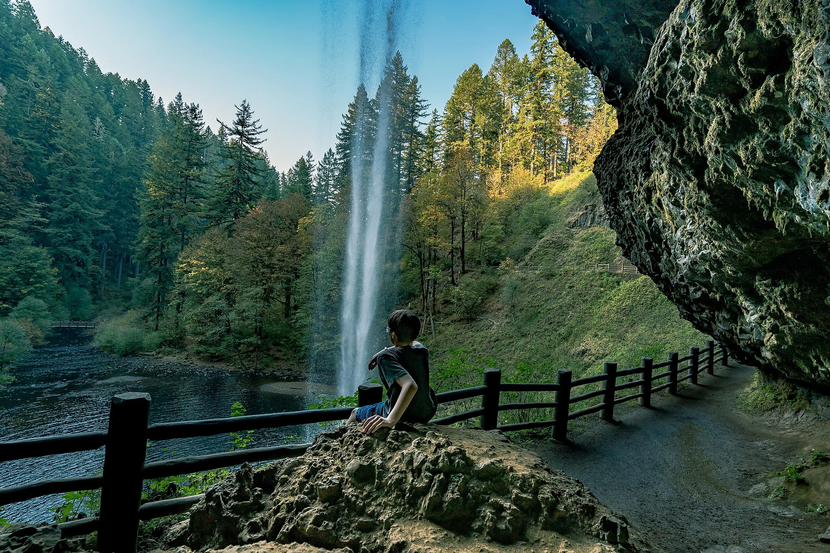
Trail of Ten Falls: Oregon

The largest state park in Oregon conveniently sits just East of Salem, roughly equidistant from Eugene and Portland, and features a looped trail that is rich in waterfalls. The aptly-named Trail of Ten Falls explores 7.8 miles of the 9,000-acre Silver Falls State Park (gaining 1,300 feet of elevation in the process), or if you prefer, there are two shortcut trails that create a more modest walk. In any case, the trailhead is right next to the South Falls parking lot, and has a cafe to help give visitors a little kick before heading off, or to refresh themselves at afterwards. Unlike some entries on this list, the Trail of Ten Falls is doable year round. But for the crisp waterfall experience, as well as lessened crowds, Spring is the recommended season.
Wonderland Trail: Washington

The Wonderland Trail is probably my favorite hike I've never done. Though I haven't yet had the pleasure, stories from my peers, combined with captivating YouTube documentaries have etched this 93-mile circuit firmly into my mind's eye, and my adventure bucket-list. Though the distance and cumulative elevation gain (approximately 22,000 feet!) make this route a serious challenge, the fact that it starts and finishes in the same place is refreshing from a logistical point of view. And even though there are few flat sections in this part of Mount Rainier National Park, the continuous views of the 14,417-foot titular mountain keep spirits and endorphins high. This popular entry requires a wilderness permit, and camping is only designated at official sites – of which there are 18 and counting.
It is tough to think of a better region for hiking than the Pacific Northwest. The terrain is diverse, vibrant, challenging, and arrestingly scenic, and the four distinct seasons add even more variety into the mix for returning wanderers. There are mountains to climb, beaches to visit, and forests to bathe in. Some trails are easily accessible, while others require a mini adventure to reach. But no matter where you go, the free and organic atmosphere is sure to connect you deeply to nature, and the self-revealing power that great hikes exude.