Cascadia Subduction Zone
Cascadia Subduction Zone is a 600-mile-long dipping fault located at the convergent boundary between the continental North American and the oceanic Juan de Fuca tectonic plates, approximately 70 to 100 miles off the Pacific Ocean shore. The fault stretches from Canada's Northern Vancouver Island to Northern California's Cape Mendocino. It is believed that the Cascadia Subduction Zone can generate mega earthquakes with a magnitude of 9.0 or greater and giant tsunamis that can reach over 100 ft. Some of the major cities that are most prone to disturbances caused by this subduction zone include the US cities of Seattle in Washington and Portland in Oregon; and the Canadian cities of Victoria and Vancouver in British Columbia.
Geography Of Cascadia Subduction Zone

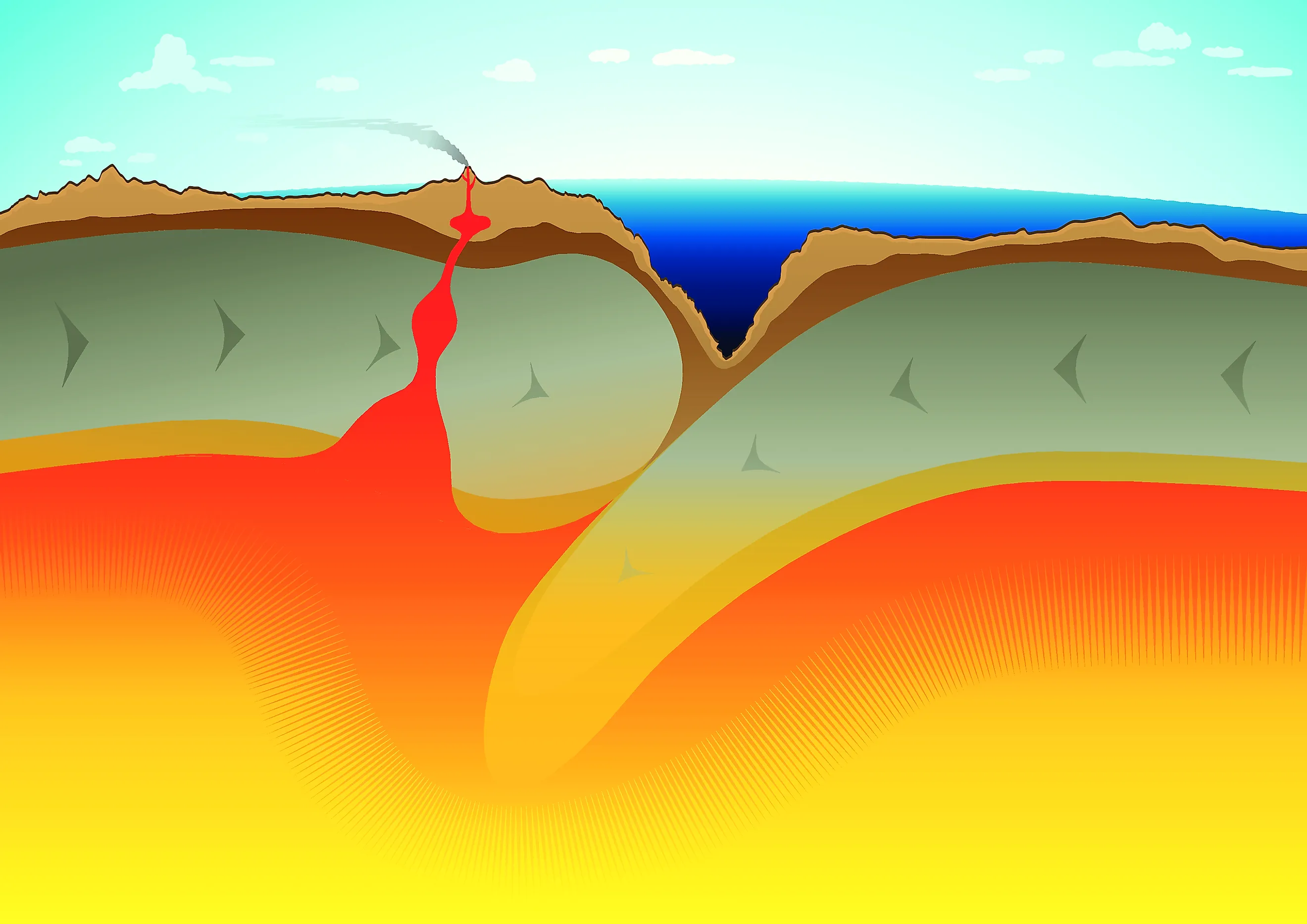
The Cascadia subduction zone is an extremely long, sloping subduction zone that extends from Northern California’s Cape Mendocino to the Brooks Peninsula of Vancouver Island in British Columbia. All along this zone, which starts under the seafloor to the west and stretches inland towards the Cascade and Coastal mountains; the Juan de Fuca, Explorer, and Gorda plates are forced to subduct below the comparatively larger North American Plate. In addition, in this zone, the oceanic crust of the Pacific Ocean has been sinking under the North American Plate for over 200 million years, and at present, at a rate of about 40 mm per year.
It is to be noted that the Pacific Northwest region of the United States is located within a tectonic collision zone. A major portion of California, Washington, Oregon, and British Columbia sits on the edge of the North American Plate. This plate is being continuously pushed slowly against a system of plates beneath the Pacific Ocean. The Juan de Fuca, Gorda, and Explorer plates are made up of denser rock material than the North American Plate and are driven below it in a process known as subduction. The slow consistent movement that forces these plates together leads to the build-up of a tremendous strain while the plates stick together. The sudden release of this immense strain will generate earthquakes of high magnitudes.

The Cascadia zone is believed to be “locked” by friction at a relatively shallower depth of about 19 miles. Just below this locked zone, the plates have been made more pliable by the warmer temperatures, making them move readily past each other. Deep down, this free movement causes an accumulation of strain all along the locked zone. As the subduction forces continue to act, the stress builds up slowly till the frictional strength of the fault is exceeded. At this time, along the fault, the rocks would slip past each other, eventually resulting in what scientists term “megathrust earthquakes.” Moreover, the North American Plate’s deformed western edge will bend, leading to a drop in elevation of as much as 6.6 ft along larger sections of Cascadia’s coastline, through an effect referred to as the “co-seismic subsidence.”
Several triple junctions run in the northern and southern ends of the Cascadia subduction zone. Immediately below the Haida Gwaii archipelago in the north, the Cascadia subduction zone is intersected by the Explorer Ridge and the Queen Charlotte Fault. At the Mendocino Triple Junction, just off California’s Cape Mendocino in the south, the Cascadia subduction zone is intersected by the Mendocino Fracture Zone and the San Andreas Fault.
Earthquake Types Of Cascadia Subduction Zone
The collision of the various tectonic plates along the Cascadia subduction zone as well as the geometry and geology of these plates results in the generation of different types of earthquakes. Some of these earthquake types have been discussed below:
Deep Earthquake

This type of earthquake is usually seen in the “descending slab” at a depth of about 30 to 37 miles. As this quake type originates deep below the ground, it leads to less damage in comparison to a shallow quake of comparable size. Moreover, the deep quake produces only a few aftershocks, and its effects can be felt over a larger area. An example of a deep earthquake is the Nisqually Earthquake which took place in 2001 and had a magnitude of 6.8.
Shallow Or Crustal Earthquake
This type of earthquake occurs within the North American Plate along fractures created due to the collision and pushing of continental crust blocks. It is estimated that whenever such shallow fault breaks, the resulting earthquake would affect a comparatively smaller area than that of a deep earthquake of the same magnitude, but there would be more intense shaking with numerous aftershocks. If the rupture is placed under a water body, then the shallow earthquake will generate a local tsunami. The two strong earthquakes having a magnitude of 6.0 that struck Oregon’s Klamath Falls in 1993 are examples of shallow or crustal earthquakes.
Subduction Zone Earthquakes

The convergent boundary along which the Juan de Fuca, Gorda, and Explorer plates have been sinking underneath the North American Plate can generate earthquakes of large magnitudes. This earthquake type is followed by significant aftershocks and can also produce tsunamis. An example of this type of earthquake is the Cape Mendocino earthquake that struck in 1992, having a magnitude of 7.1.
Notable Facts About Cascadia Subduction Zone

The various tectonic processes that are active in the Cascadia subduction zone include subduction, accretion, active volcanism of the Cascade Volcanoes, and deep earthquakes. In previous years, the active volcanism of this zone led to some significant volcanic eruptions, such as the eruption of Mount Mazama about 7,500 years ago; the eruption of Mount Meager massif about 2,350 years ago; and the 1980 eruption of Mount St. Helens.
On January 26, 1700, the last known “megathrust earthquake” took place along the Cascadia subduction zone, which had an estimated magnitude between 8.7 and 9.2. Although there are no written records of this earthquake, it is believed that it caused the coastline to drop several feet and generated a tsunami that struck both North America’s western coast as well as the coast of Japan. Several Native American legends and Japanese historical records have also supported the timing of this event. Geological studies revealed that about 41 subduction zone earthquakes have taken place in the Pacific Northwest in the past 10,000 years. Moreover, on average, Cascadia subduction zone earthquakes have occurred every 243 years.
The Cascadia subduction zone has not generated a mega earthquake since 1700, and pressure has been continuously building up in the area where the Juan de Fuca Plate is undergoing subduction underneath the North American Plate. Researchers predict that there is a 37% chance of a megathrust earthquake having a magnitude of more than 7.1 in this fault zone in the next 50 years. It is also predicted that the effects of this earthquake will be felt greatly throughout the Pacific Northwest region, with numerous fatalities, infrastructural damages, and displacement of millions of people. Therefore, the residents of the Pacific Northwest who live in earthquake-prone areas must prepare in advance for the next mega earthquake.