The Phantom Island That Stayed On Lake Superior Maps For A Century
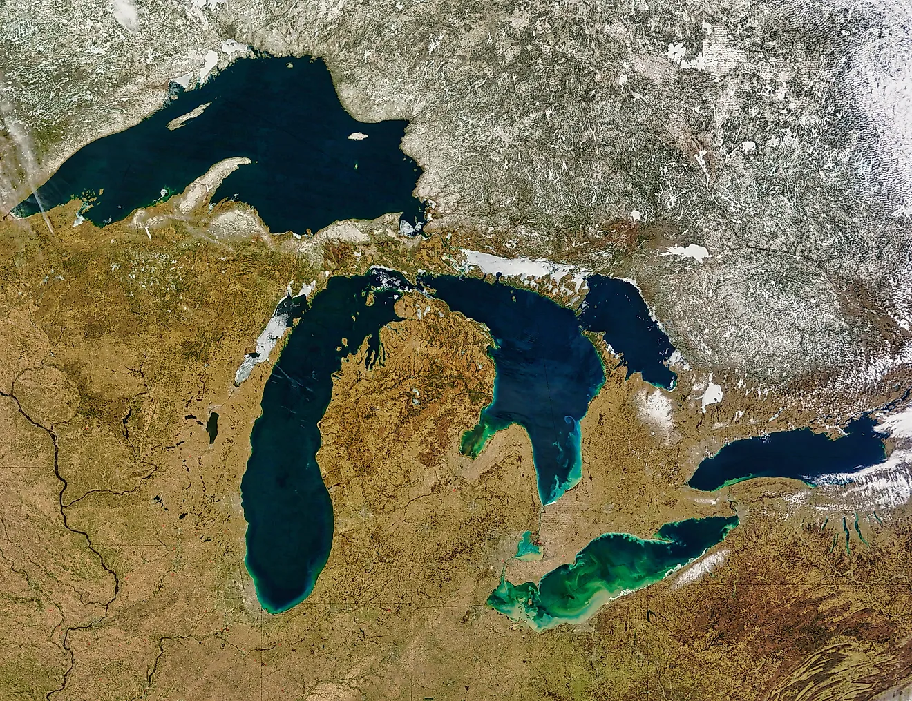
The treaty that created the United States contains an island that does not exist. When British and American negotiators drew the new nation's northern boundary in the 1783 Treaty of Paris, they ran the line through Lake Superior "northward of the Isles Royal and Phelipeaux", two landmarks given equal billing, one of them the very real, 45-mile-long Isle Royale, and the other a complete cartographic fiction, a phantom called Isle Phelipeaux that had been sailing across maps of Superior for four decades without ever troubling the actual lake. The island survived on charts for the better part of a century, long enough to be written into the founding geography of a country, and the story of how a nonexistent place acquired that much legal real estate is a tour of how maps really worked before anyone could check.
A Flattering Invention

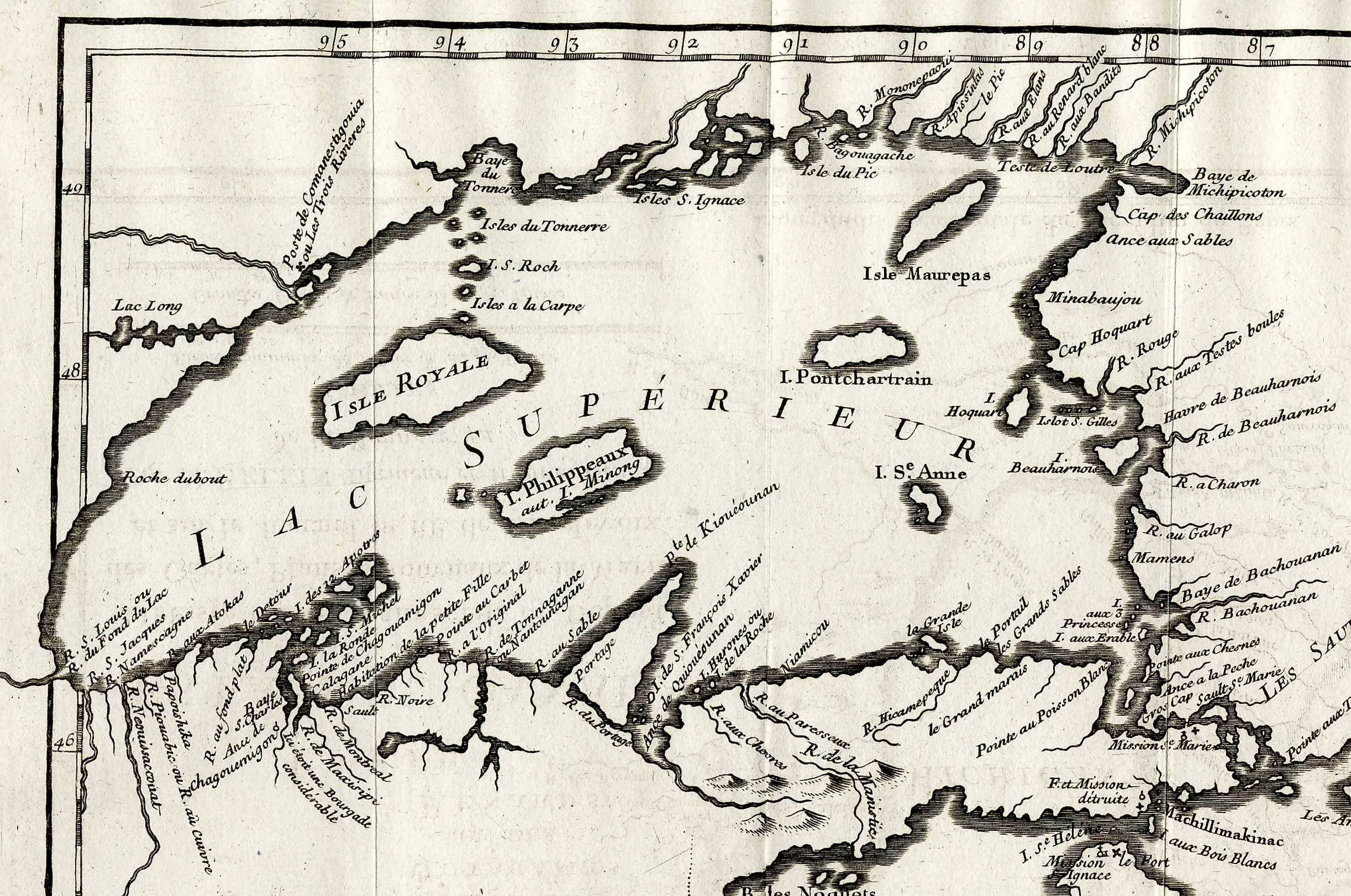
Isle Phelipeaux made its debut in the 1740s on charts associated with Jacques-Nicolas Bellin, the respected hydrographer of the French crown, whose maps of New France were the era's standard references. Bellin's Lake Superior came generously furnished: alongside real islands, it carried a small fleet of large phantoms, Phelipeaux chief among them, accompanied by an Isle Pontchartrain and company, and the names give the game away, because Phélypeaux and Pontchartrain were the family names and titles of the Count of Maurepas, the French minister of marine, Bellin's ultimate patron. The most charitable reading is garbled reports from traders and a possible double-counting of a real island; the most popular reading, then and now, is that a mapmaker planted imaginary islands in a distant lake and christened them after the man who approved his budget.
Either way, the phantom was no sketch. Phelipeaux appeared as a substantial landmass holding a confident position in eastern Superior, drawn with the same authority as everything else on the sheet, and authority, it turned out, was the only seaworthiness a map island needed.
How A Fake Island Survives

The phantom's longevity ran on the publishing economics of the age: cartographers copied cartographers. Original surveys of a remote, fog-prone, gale-swept inland sea were staggeringly expensive and rare, so each new map of the Great Lakes was compiled overwhelmingly from previous maps, and an island introduced by an authority as credible as Bellin was faithfully inherited by British, French, and American mapmakers for generations, each reproduction laundering the invention into better-established fact. Nobody was positioned to falsify it, since the voyageur canoe routes hugged Superior's shores, and no commercial traffic had any reason to stand out into the empty middle distance where Phelipeaux supposedly lay.
If the island had a seed at all, the best candidate is Michipicoten Island, a real and respectable landmass in eastern Superior that period maps sometimes rendered twice from conflicting reports, once under its own name and once, enlarged and displaced, as the minister's island. Duplication, flattery, and a century of diligent copying: the recipe for immortal geography that never existed.
Written Into The Border

The phantom's career peaked in Paris in 1783. Negotiating the boundary of the newly independent United States, Benjamin Franklin and his British counterparts worked from the finest map available, the famous Mitchell Map of North America, which dutifully carried Superior's inherited islands, and the treaty's text routed the border through the lake "northward of the Isles Royal and Phelipeaux" to the Pigeon River country. A diplomatic instrument of world-historical consequence thereby took a navigational fix from an island that was not there, placing Phelipeaux alongside Isle Royale as twin monuments of the new republic's edge.
The error slept for a generation until the border had to be surveyed in earnest. After the War of 1812, joint boundary commissions took to the lakes to translate treaty language into charted line, and in the 1820s their surveyors crisscrossed eastern Superior looking for the treaty's second island with increasing bafflement, finding only open water, weather, and depth. The United States and Britain had, in effect, dispatched official expeditions to locate a courtier's compliment, and the compliment had nothing to say.
The Eraser

The surveys of the 1820s ended the phantom's run. With the commission's charts showing eastern Superior conclusively empty, Phelipeaux and its courtly companions were struck from serious maps, roughly 80 years after their invention, and the boundary was resolved on real geography, running north of the genuine Isle Royale, which is why that island, hard against the Canadian shore, belongs to Michigan to this day, a quirk the treaty's island-hopping language locked in. The border survived its imaginary landmark; the landmark did not survive the border's surveyors.
What makes the ending satisfying is who did the erasing. The phantom had been created by authority and sustained by copying, and it was killed by the one force maps had rarely met on Superior before: somebody actually going to look. The boundary commissions were the lake's first systematic truth-check, and Phelipeaux was simply the largest thing they subtracted.
The Phantom's Company
Superior's fake island belongs to a grand tradition. Cartography's history is littered with phantoms that outlived their inventors, from the Atlantic's wandering Hy-Brasil to islands that haunted Pacific charts into the age of steam, and the genre is not entirely closed: as recently as 2012, a research vessel "undiscovered" Sandy Island, a Manhattan-sized phantom between Australia and New Caledonia that had survived into modern digital maps before a ship sailed through its coordinates and found a thousand meters of water. Phantom islands persist wherever checking is expensive and copying is cheap, which described Lake Superior perfectly for a century.
Phelipeaux remains the tradition's great overachiever all the same. Other phantoms fooled sailors and atlas buyers; this one got itself cited in the birth certificate of a nation, surveyed by two governments, and only then dismissed, an imaginary island with a better diplomatic record than most real ones. Maurepas, for the record, was long dead before anyone went looking for his island. The flattery outlived the flattered, which may be the most cartographic ending of all.
The Island That Was A Compliment
So the phantom of Lake Superior was most likely a bow to a patron, drawn with authority, copied into permanence, promoted into a treaty, and finally erased by the first surveyors who bothered to visit its address, a full lifecycle of fictional geography run from the 1740s to the 1820s. The lake it haunted keeps the moral on display: Superior is still vast enough, foggy enough, and empty enough in the middle that a confident mapmaker once furnished it with islands and the world took his word for the better part of a century. The border found its way to the real islands in the end. But somewhere in the treaty that made the United States, Isle Phelipeaux is still on the books, the most consequential piece of land that never was.