The 8 US States Located In The Great Lakes Region
Located in the east-central portion of the continent of North America, the Great Lakes is a series of five interconnected deep freshwater lakes which include Lake Superior, Lake Huron, Lake Michigan, Lake Erie, and Lake Ontario. The Great Lakes cover a vast area of 244,106 sq. km and forms the largest freshwater body on earth. These lakes drain into the Atlantic Ocean via the Saint Lawrence River and are believed to be the remnants of large glaciers that melted about 14,000 years ago at the end of the Last Glacial Period.

The Great Lakes serve as a natural border between the United States and Canada and touch the US States of Wisconsin, Pennsylvania, Ohio, New York, Minnesota, Michigan, Indiana, and Illinois as well as the Canadian province of Ontario. The Great Lakes play a very important role in shaping the physical, social, cultural, and economic landscape of both Canada and the United States. It has been estimated that more than 85 million people reside in the Great Lakes region.
Wisconsin

Touching the shores of both Lake Superior and Lake Michigan, Wisconsin is the 23rd largest and the 20th most populous US state that is located in the upper American Midwest. Wisconsin has over 1609.34 km of Great Lakes shoreline and more than 20% of the state’s land area is located within the Great Lakes basin. It is estimated that more than 1.6 million people of Wisconsin receive their vital drinking water supply from Lake Michigan and Lake Superior.
Milwaukee – the largest city in the State of Wisconsin along with the cities of Kenosha and Green Bay is located on the southwestern shores of Lake Michigan. Wisconsin serves as one of the country’s leading dairy producers and is most well-known for its cheese. Both Lake Michigan and Lake Superior play a vital role in the state’s economic growth by supporting the manufacturing businesses and the growing tourism industry of the state. The harbors and marinas on the shores of the Great Lakes in Wisconsin support a recreational boating industry worth 9.4 billion dollars/year. More than 250,000 anglers enjoy their sport-fishing opportunities in the Great Lakes of Wisconsin. The lakes also serve to connect the state’s interior parts with the major shipping ports and in turn with the global markets. It has been recorded that more than 7 billion dollars worth of cargo passes through the ports of Wisconsin every year.
Pennsylvania

With an area of 119,283 sq. km, Pennsylvania is the 33rd largest and the 5th most populous US state. Pennsylvania borders approximately 72.4km of shoreline along Lake Erie. The “Flagship City” of Erie is one of the largest cities in Pennsylvania and features the state’s only seashore due to its location on the southern shores of Lake Erie. The Port of Erie is the state’s only Great Lakes port that handles approximately 600,000 tons of inbound and outbound cargoes every year.
Ohio

With Lake Erie on its northern border, Ohio is the 34th largest and the 7th most populous US state that is located in the American Midwest. Ohio has about 502km of coastline with Lake Erie that has made way for the development of many cargo ports including Toledo, Cleveland, Sandusky, Marblehead, Lorain, Huron, Fairport Harbor, Conneaut, and Ashtabula. The port of Toledo serves as the 5th busiest among the ports of the Great Lakes and the 54th biggest port in the entire United States. The nine Great Lakes ports of Ohio handles approximately 40 million tons of inbound and outbound cargoes each year.
New York

With an area of 141,300 sq. km, New York is the 27th largest and the 4th most populous US state. New York has a 928.5km of shoreline along Lake Erie and Lake Ontario that is connected via the Niagara River and drains into the Atlantic Ocean via the Saint Lawrence River. New York is also bounded by the Atlantic Ocean on the east and is, therefore, the only US state that includes both the Atlantic Ocean and parts of Great Lakes within the state’s borders. The state’s four Great Lakes ports including Buffalo, Ogdensburg, Oswego, and Rochester handles over 2.3 million tons of inbound and outbound cargoes each year.
Minnesota

With an area of 225,163 sq. km, Minnesota is the 12th largest and the 22nd most populous US state. Minnesota has 437.74km of coastline along Lake Superior in the state’s extreme northeastern side. The Great Lakes Seaway shipping plays a critical role in the state’s mining and agricultural sectors. The state’s four commercial ports including Duluth/Superior, Taconite Harbor, Two Harbors and Silver Bay handles over 58 million tons of inbound and outbound cargoes each year.
Michigan

With an area of about 250,000 sq. km, Michigan is the 11th largest US state by area and the 10th largest US state by population. Michigan is bordered by four of the five Great Lakes and has the longest freshwater coastline than any other political subdivision in the world. The State has more than 5149.9km of shoreline on four of the five Great Lakes which include Lake Michigan, Lake Superior, Lake Huron, and Lake Erie. There are about 25 Great Lakes ports in Michigan including Detroit, Cheboygan, Escanaba, Ludington, Marysville, Port Dolomite, etc. It has been estimated that about 64 million tons of inbound and outbound cargoes are handled by Michigan’s Great Lakes ports every year.
Indiana

With an area of 94,321 sq. km, Indiana is the 38th largest and the 17th most populous US state. Indiana has 69.2km of shoreline and borders a small portion of Lake Michigan in the extreme northwestern part of the state. Being the US’s largest steel-producing state, Indiana depends on the Great Lakes Seaway shipping for delivery of all the critical raw materials. The state’s four Great Lakes ports including Buffington Harbor, Burns Harbor, Indiana Harbor, and Gary handles more than 31 million tons of inbound and outbound cargoes every year.
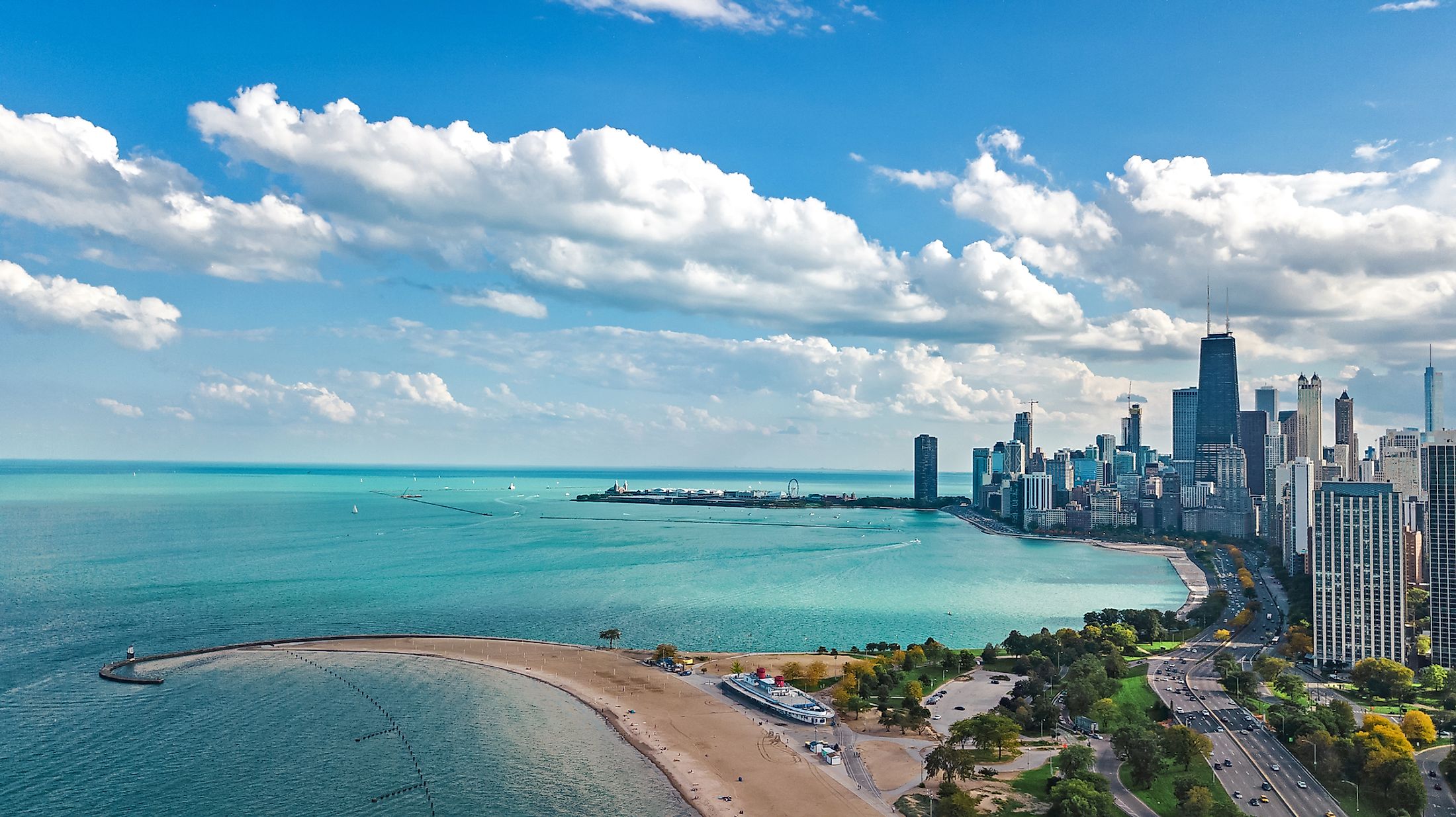
Illinois

With an area of 149,997 sq. km, Illinois is the 25th largest US State by area and the 6th largest US State by population. Illinois borders 101.38km of Lake Michigan in the extreme northeastern part of the state. The 101.38km long Great Lake shoreline of the state is dominated by the city of Chicago, which is also the largest city in the Great Lakes Seaway region. The Great Lakes Seaway shipping route is therefore very vital to the dynamic economy of the northeastern part of Illinois. Several local manufacturers depend on this waterborne transportation for the export of their various products in different parts of the country as well as throughout the world. It is estimated that more than 16 million tons of inbound and outbound cargoes are handled by the state’s ports every year.


