What Is The Indus Waters Treaty?
The Indus River is among the most consequential rivers in the world, supporting lands from the Himalayas to the plains of Pakistan. Its location has shaped the fate of surrounding nations for millennia. The 1960 Indus Waters Treaty allowed India and Pakistan to share the river's waters peacefully for more than six decades, but after a militant attack in Indian-administered Kashmir in April 2025, India placed the treaty in abeyance, disrupting the long-standing arrangement. Here is the history and current state of an agreement that affects more than 300 million people across the two neighboring nations.
History Of The Indus Waters Treaty
The dispute that the Indus Waters Treaty was designed to settle began with the Partition of British India in 1947. The new border separated the headworks of the Indus canal system, located in India, from the agricultural lands they served, located in Pakistan. A Standstill Agreement briefly maintained the existing flow of water across the new border. When that agreement expired in April 1948, India temporarily withheld water from canals running into Pakistan. The canals dried up. A second short-term arrangement, the Inter-Dominion Accord of May 1948, restored the flow in exchange for annual payments from Pakistan.
Three years passed before formal negotiations began. In 1951, the American jurist David Lilienthal, who had previously led the Tennessee Valley Authority and the U.S. Atomic Energy Commission, traveled through the region researching articles for Collier's magazine and proposed that India and Pakistan jointly develop and administer the Indus river system. Eugene Black, then president of the World Bank, agreed to broker negotiations. Engineers from both countries formed a working group with World Bank advisors. Political disagreements stalled the talks for years.
The World Bank submitted its own proposed solution in 1954. After six more years of negotiation, the Indus Waters Treaty was signed in Karachi on September 19, 1960, by Indian Prime Minister Jawaharlal Nehru, Pakistani President Mohammad Ayub Khan, and W. A. B. Iliff of the World Bank. The treaty took effect retroactively to April 1, 1960. It allocated the three eastern rivers, the Ravi, Beas, and Sutlej, to India for unrestricted use, and the three western rivers, the Indus, Jhelum, and Chenab, to Pakistan, with limited rights granted to India for non-consumptive uses such as hydroelectric generation. A separate Indus Basin Development Fund Agreement, signed the same day, brought funding from Australia, Canada, West Germany, New Zealand, the United Kingdom, the United States, and the World Bank to finance the canals and dams Pakistan needed to replace what it lost on the eastern rivers. The treaty also created the Permanent Indus Commission, with one commissioner from each country, to handle disputes through a defined arbitration process.
Disputes Arise
For decades the treaty held through three Indo-Pakistani wars and the Kargil conflict of 1999, leading many international observers to describe it as the world's most successful transboundary water-sharing agreement. The most serious dispute under the treaty arose in 2017, when India completed the Kishanganga hydroelectric project in Kashmir and continued construction on the Ratle hydroelectric plant on the Chenab River. Pakistan objected, arguing that both projects violated the treaty's restrictions on Indian use of the western rivers. In 2022, the World Bank appointed both a Neutral Expert (at India's request) and a Court of Arbitration (at Pakistan's request) to handle the dispute, an unusual parallel-track outcome. India objected to the Court's competence, and in January 2023 formally requested a bilateral renegotiation of the treaty. Pakistan declined.
The most damaging shock came on April 22, 2025, when armed militants killed 26 civilians, mostly Hindu tourists, near Pahalgam in Indian-administered Kashmir. India attributed the attack to a Pakistan-based group, which Pakistan denied. The day after the attack, India announced that it would hold the Indus Waters Treaty in abeyance, the first time either country had taken such a step. India also closed the main Attari-Wagah land border crossing, expelled diplomats, and weeks later carried out airstrikes inside Pakistan as part of a military operation it called Sindoor. Pakistan responded with strikes of its own, and the two nuclear-armed neighbors entered the most serious military confrontation between them in decades before a ceasefire took hold.
As of April 2026, one year on, the treaty remains in abeyance. India and Pakistan have each accused the other of breaching the agreement. The Court of Arbitration issued a supplemental award in June 2025 affirming its competence over the dispute, but the treaty's full operation has not been restored.
The Indus River Today

Modern use of the Indus is extensive. Large-scale irrigation engineering on the river began under British administration in the mid-1800s, with new canal systems built and older ones modernized. The Indus Basin Irrigation System is now one of the largest contiguous irrigation networks in the world, covering more than 47 million acres in Pakistan alone. Dams and barrages, including Tarbela on the Indus and Mangla on the Jhelum, store and distribute water for drinking, irrigation, and hydroelectric power. Hydroelectric facilities such as the Ghazi-Barotha project on the Indus supply a significant share of Pakistan's electricity. Major cities including Karachi, Lahore, and Multan rely directly on the system for daily water needs. Agriculture, which contributes roughly a quarter of Pakistan's GDP, depends on Indus water for around 90 percent of its irrigation; the principal crops grown along the canals include wheat, rice, sugarcane, and cotton.
The Indus River's Regional Importance

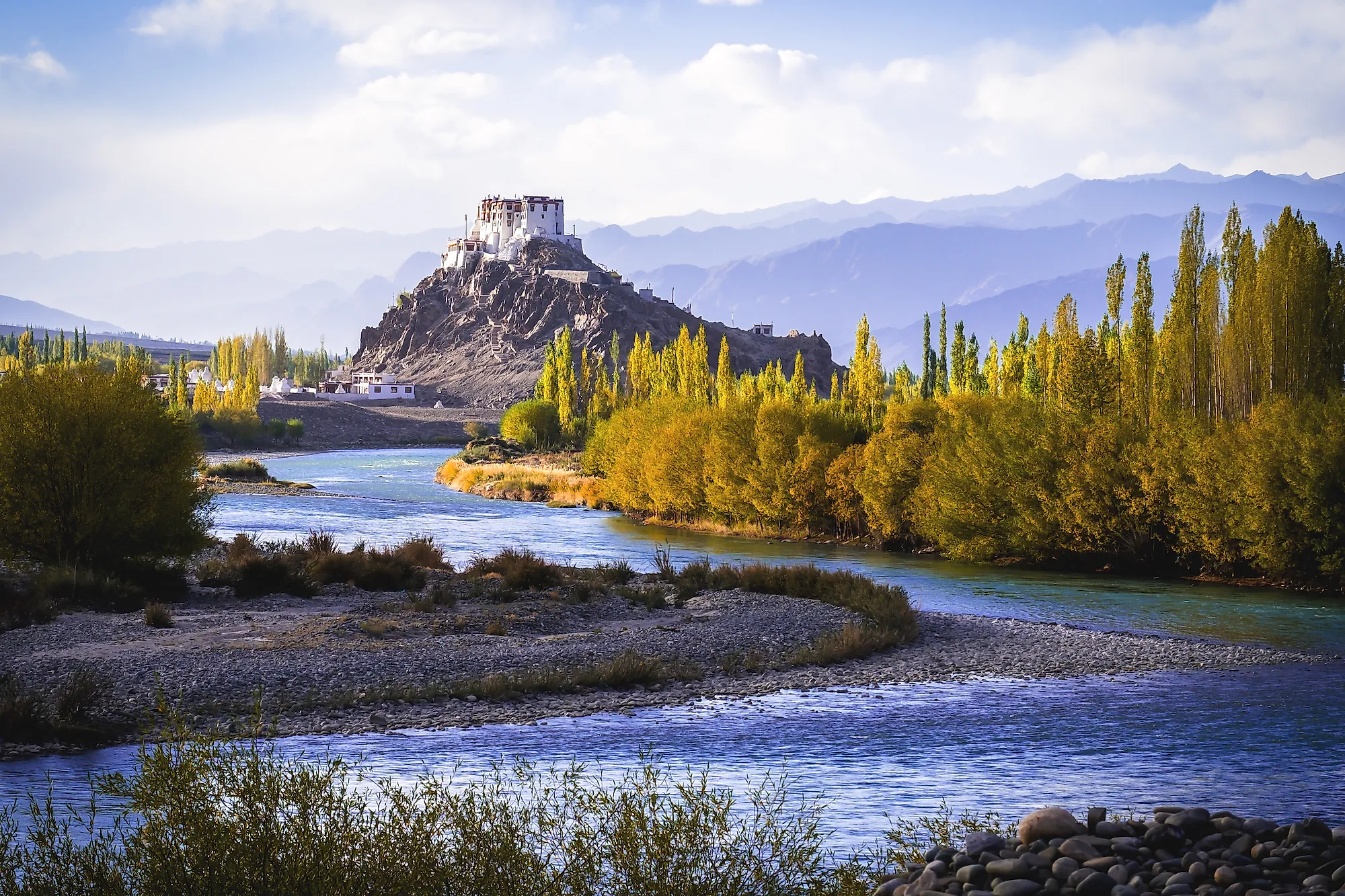
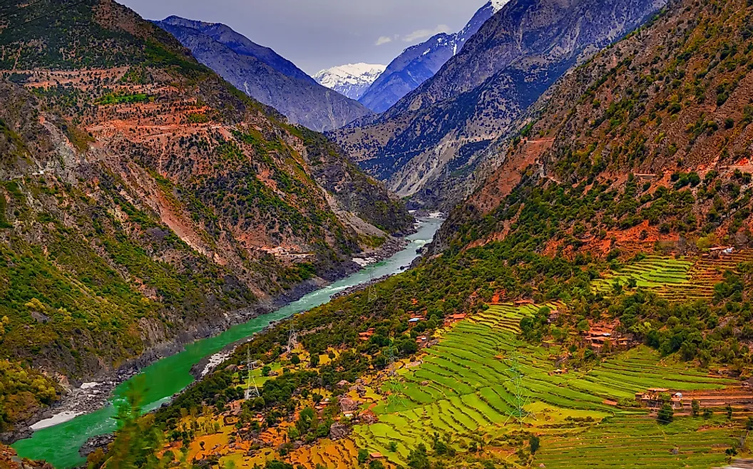
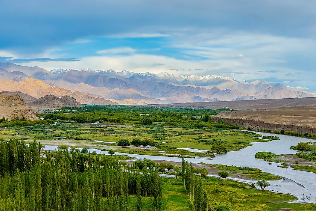
The Indus is approximately 1,980 miles (3,180 kilometers) long and crosses several mountain systems and climate zones in South Asia. It rises in southwestern Tibet near Lake Mapam (also known as Lake Manasarovar) at roughly 18,000 feet, flows about 200 miles northwest, and crosses into the union territory of Ladakh in India-administered Kashmir. Just beyond Leh, it is joined on its left bank by its first major tributary, the Zanskar River. It then flows another 150 miles into the Pakistani-administered areas of Kashmir, where it is joined on the right by the Shyok River. From there, the river is fed by glacial melt from the Karakoram and Nanga Parbat ranges as it passes through deep gorges before emerging onto the plains of Pakistan.
The Indus receives its most important tributaries from the eastern Punjab plain. These five rivers, the Jhelum, Chenab, Ravi, Beas, and Sutlej, give Punjab ("Five Rivers") its name. The Kabul River joins the Indus from the west near Attock. After receiving these tributaries, the Indus widens, flows slowly across the southern plain at low elevation, and divides into distributaries that form a large delta southeast of Karachi before emptying into the Arabian Sea.
The river is fed largely by snowmelt and glacial melt from the high ranges, which means that flow is heaviest in summer and that the system is especially sensitive to climate change in the Himalayas and Karakoram. The monsoon rainy season, from July to September, can also produce major floods. Embankments protect the plains, but in the floods of 1947, 1958, and 2010, water broke through and shifted the river's course. These same floods, in less destructive years, deposit the silt that has made the Indus plain agriculturally productive for thousands of years.
A Cradle Of Civilization

The Indus has supported settled human civilization for at least five thousand years. The Indus Valley Civilization, which flourished from roughly 3300 BCE to 1300 BCE with its mature urban phase between about 2600 and 1900 BCE, was one of the three earliest urban civilizations on Earth, alongside those of Mesopotamia and Egypt. Its largest cities, Harappa and Mohenjo-daro, both in present-day Pakistan, contained tens of thousands of residents living in planned grids with covered drainage and standardized brick. Like its Mesopotamian and Egyptian counterparts, the Indus Valley Civilization depended on a great river for irrigation, transport, and food. That dependence has not changed. The same river still feeds the cities, farms, and economies that sit along its banks today, which is why the standoff over the treaty matters far beyond the diplomatic record.
A Treaty That Sustains Life

The Indus River has long been the source of life for the lands between the Himalayas and the Arabian Sea. The 1960 treaty was a rare diplomatic achievement: an agreement that survived three wars and decades of political hostility. Its abeyance is the most significant disruption to the system in 65 years, and the longer the situation continues, the greater the strain on Pakistan's water-dependent economy and on regional stability. Whether and how the two countries return to the treaty will be one of the most consequential water-policy questions of the next decade.