9 Prettiest Main Streetscapes In The Rockies
Few walks beat a Rocky Mountain main street with a peak standing at the far end. Prospectors struck silver and gold here in a hurry, and the miners wanted somewhere to spend their pay. So up went two or three blocks of brick storefronts, most of them still standing. Locals have loved these streets enough to keep them whole for more than a century. Nine of the best are below, each one worth a slow morning on foot.
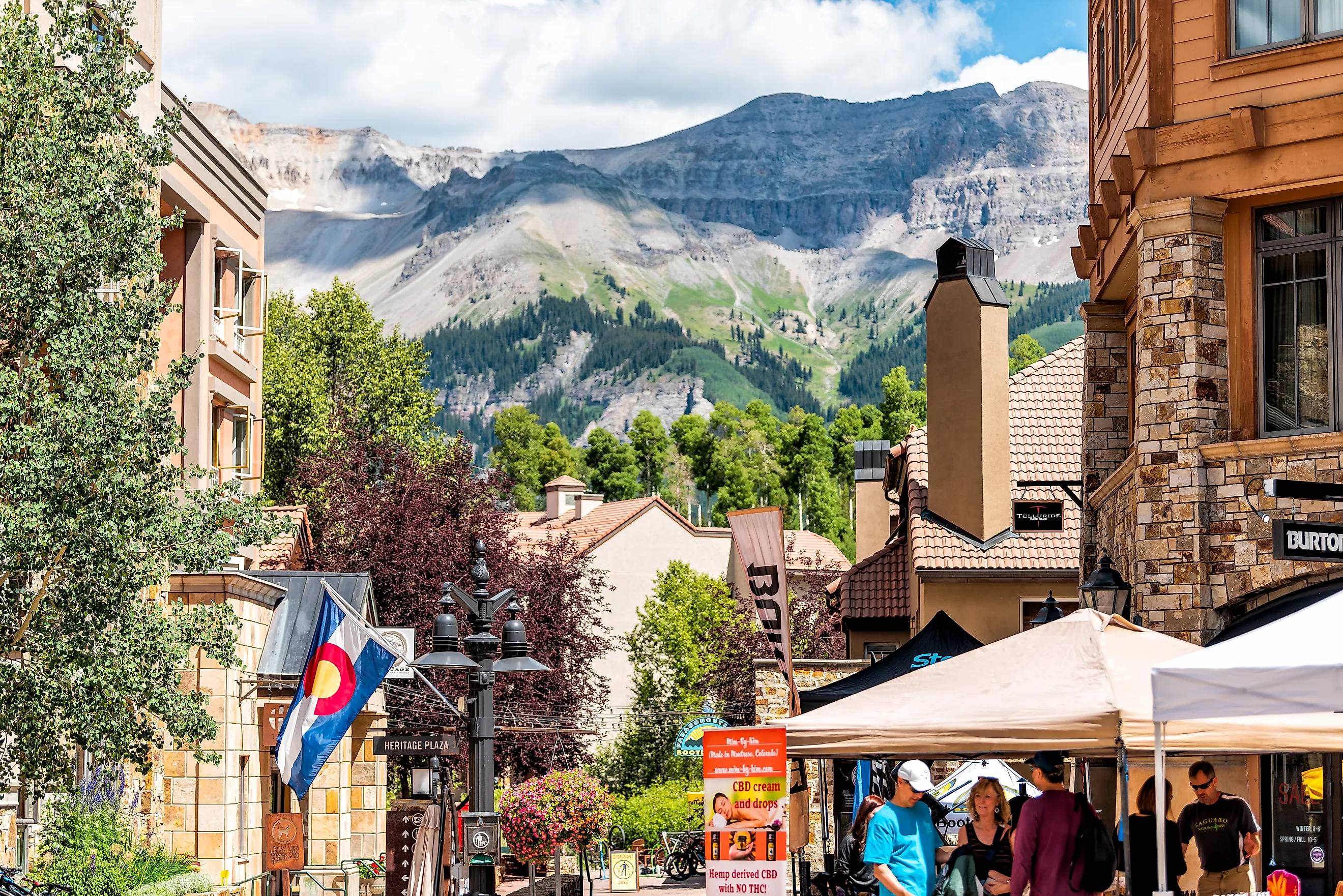
Colorado Avenue, Telluride, Colorado

Telluride sits at the closed end of a box canyon, hemmed by walls that top 13,000 feet on three sides. About 2,600 people live along the floor of it. Colorado Avenue is the length of the town, a National Historic Landmark District, and its storefronts stay low enough for the peaks to fill the view at one end and Ingram Falls at the other.
The town's most famous ride costs nothing. The gondola between Telluride and Mountain Village is the first and only free public transit of its kind in the United States, built in 1996 to keep cars out of the valley. The trip climbs roughly 1,790 vertical feet in about thirteen minutes, and it runs until midnight through the summer. Take it at sunset even with nowhere to be on the far side.
Drive Colorado Avenue east until the pavement quits and you reach Bridal Veil Falls, which drops 365 feet as the tallest free-falling waterfall in Colorado. A private historic power plant still stands at the lip of it. The road up closes for the winter. Ice climbers rate the frozen falls among the region's hardest. Save the Telluride Historical Museum and its mining exhibits for last, at around $9, after you have walked the avenue once with your head up.
Main Street, Ouray, Colorado

Drive in from the north on US 550 and the cliffs split open to reveal a 19th-century mining town on the canyon floor. People call Ouray the Switzerland of America, and the roughly one thousand residents have earned the comparison. Silver prospectors laid out Main Street in the 1880s, and the Victorian storefronts along this National Historic District have changed little since. Stop at the Visitors Center or the county museum first for a free map that covers the houses as well as the shops.
People have soaked at the Ouray Hot Springs Pool at 1200 Main Street since 1927. The sulfur-free mineral water comes in several temperatures across the complex: an 80-degree lap pool, a 104-degree soak, an overlook pool with an infinity edge, and a shallow family end. Locals will tell you February is the time to come, chin-deep in warm water with snow stacked on the canyon rim above.
More water sits at the edges of town. Box Canyon Falls drops 285 feet through a quartzite slot just outside it, Cascade Falls is a quarter-mile past the end of Eighth Avenue, and the Perimeter Trail is a loop around the basin, with several points that look straight down onto Main Street.
Elk Avenue, Crested Butte, Colorado

Elk Avenue is the main street of one of Colorado's largest historic districts, and it is easily the most colorful street here. Painters have coated the Victorian storefronts in a range of shades that should clash and somehow never do. About 1,500 people live at 8,885 feet, closed in by the Elk Mountains on every side.
Inside the Crested Butte Mountain Heritage Museum at 331 Elk Avenue, you get the mining, skiing, and ranching years, plus a Ute display and a model railroad set in the town as it looked in the 1920s. A quarter sets the model train going. Museum staff also lead walking tours of the avenue and, once a year, a guided crawl through four to six of the historic bars.
Colorado named Crested Butte its official Wildflower Capital, and locals back the title up each July with ten days of guided hikes, garden tours, and workshops. The bloom peaks from July into August, heaviest in the Gothic Valley and around Kebler Pass. Twenty minutes up the road, the old ghost town of Gothic reopens every summer as a mountain research station.
Town Square, Jackson, Wyoming

The centerpiece in Jackson is a square rather than a street, and it earns a spot here anyway. George Washington Memorial Park is the middle of downtown, and an arch built entirely from shed elk antlers rises over each of its four corners. Raised wooden boardwalks run around the square, and they do more for the Old West feel than any painted sign could.
The Jackson Hole Rotary Club raised the first arch in 1953 and finished the fourth by 1969. Each one holds more than 2,000 antlers and around 14,000 pounds of bone, stacked by hand and locked together mostly by friction and gravity. Local Boy Scouts gather the sheds every spring from the National Elk Refuge up the road, where roughly 7,500 elk winter. The bone eventually breaks down, so crews rebuild the arches about every fifty years.
The best art in town hangs 2.5 miles north on Highway 89. The National Museum of Wildlife Art occupies a stone building set into a bluff above the refuge, with 14 galleries and work from more than 550 artists, Warhol and O'Keeffe among them. Come the third Saturday in May for ElkFest, when the year's gathered antlers go to auction on the square and part of the take funds refuge habitat.
Broadway Avenue, Red Lodge, Montana

Red Lodge has twelve acres of Classical Revival, Gothic, and Romanesque storefronts between 8th and 13th Streets, on the National Register since 1983. The population reached 6,000 in 1915 and then fell to around 2,000. That bust is exactly why the buildings are still standing.
The Carbon County Historical Society and Museum is at 224 Broadway North, inside the 1909 Labor Temple. Rodeo cowgirl Alice Greenough founded it in 1959 to house her family's collection, with exhibits on coal mining, homesteading, the Crow people, the Festival of Nations, and Liver Eatin' Johnson, who once kept the law here. Inside you will find an interactive coal mine and a deep historic gun collection. A block on, the Pollard Hotel has stood since 1893, when it opened as The Spofford.
Broadway is also a trailhead. The Beartooth Highway trailhead is at the edge of town, and the road tops out at 10,947 feet on the way to Yellowstone's northeast gate. Charles Kuralt called it the most beautiful drive in America. It is closed by snow every winter. When the highway is shut, the Roman Theater on Broadway still shows films, billed as the longest continuously operating theater in Montana.
Central Avenue, Whitefish, Montana

Whitefish has under 10,000 residents, a walkable core, a lake at the city edge, and a ski hill fifteen minutes up the grade. Merchants have kept the commercial blocks along Central Avenue and Second Street since about 1910. The landmark stands at the north end, where the Whitefish Depot went up in 1928 in Tudor Revival, half-timbered walls under wide dormers.
The depot nearly came down in the 1980s after the railroad moved out. The Stumptown Historical Society bought it from Burlington Northern in 1990 and spent three years on the restoration, much of the labor volunteered by residents who wanted it kept. Amtrak's Empire Builder still stops here, and more passengers board at this depot than at any station between St. Paul and the coast. Upstairs, the free Whitefish Museum has exhibits on the town's logging and railroad past and its turn toward skiing. Residents hold the farmers market and summer arts festival in Depot Park next door.
Two trails leave from downtown: the Whitefish Trail and a 21-mile paved path over to Columbia Falls, with bike rentals a block away. One honest warning on money. Summer rooms in Whitefish routinely clear $300 a night, while Columbia Falls and Kalispell sit twenty minutes off for a good deal less.
Bank and Sixth, Wallace, Idaho

Wallace has around 800 residents, with its entire downtown on the National Register. Fire tore through in 1910, the town rebuilt in brick, and almost nothing has come down since. The whole place measures about half a mile end to end, with nearly every shop and museum a block off Bank or Sixth Street.
A manhole cover at Bank and Sixth marks the Center of the Universe. In 2004, after the EPA named the mining valley a Superfund site, the mayor declared Wallace the center of everything on the logic that no one could prove otherwise. Signs on each corner point you to the spot. Watch for traffic while you stand on it.
Two blocks tell the rest. The Northern Pacific Depot Museum at 219 Sixth is inside a 1901 chateau-style depot that crews rolled across the river, all 90 tons of it, when I-90 came through in 1985. The Oasis Bordello Museum at 605 Cedar is a former brothel left just as it was when the workers walked out in 1988, groceries still on the counter, one of five that once stood along the main street. For the fuller story, the Sierra Silver Mine Tour leaves 420 Fifth Street by trolley, 75 minutes underground with retired miners doing the talking.
Banff Avenue, Banff, Alberta

Banff Avenue is two kilometres of shops, outfitters, and restaurants, with Cascade Mountain at the north end of the view and the Bow River at the south. Photographers rank it among the most-shot streets in Canada, and you can see the reason from any point on the pavement.
Walk to the south end and cross into the Cascade of Time Gardens, a set of terraced stone paths, flower beds, ponds, and gazebos below the heritage Parks Administration Building, laid out nearly a century ago as Depression relief work. Turn around here for the classic shot back up the avenue toward Cascade Mountain. Crowds rarely reach this corner. A block off the avenue at 111 Bear Street, the Whyte Museum of the Canadian Rockies, named for the Banff painters Peter and Catherine Whyte, has a collection of mountain art, artifacts, and archives.
The park itself started a twenty-minute walk from downtown. At the Cave and Basin National Historic Site, three railway workers stumbled onto sulphur hot springs in 1883, and that discovery led to Canada's first national park. The original cave pool survives, though no one swims it now. Two practical notes: downtown parking is paid, but the Banff train station lot is free for nine hours and a five-minute walk in, and every visitor needs a park pass, around $10.50 per adult per day.
Main Street, Canmore, Alberta

Twenty minutes east of Banff, Canmore has roughly 16,000 residents under the Three Sisters, the three peaks at the head of Main Street. Miners worked coal here until 1979, and you can still read that history in the main street. Every summer, the town closes Main Street, technically 8th Street, to cars, opening the whole strip for walking among the galleries, craft shops, and patios. That single move is the best argument for picking Canmore over Banff on a July afternoon.
The Canmore Museum and Geoscience Centre has exhibits on the mining history behind the town, and the Policeman's Creek Boardwalk is a flat twenty-minute loop off Main Street along the creek, prettier than a downtown creek has any business being. For a longer outing, the Legacy Trail is 29 km of paved cycling path over to Banff, with an easy start near the visitor centre. Ride it one way and catch a shuttle back.
Streets That Kept Their Bones
Every street here shares one thing: a mountain standing at the end of it, close enough that open country is never more than a few minutes from your coffee. They kept their shape because the money that built them dried up before anyone could pave the character over, and because later on the residents decided the old blocks were worth the trouble. Volunteers in Wallace rolled a ninety-ton depot across a river rather than lose it. Neighbors in Whitefish gave up three years of weekends to save theirs. What you walk today is a working main street rather than a stage set, with hardware stores and saloons and bakeries still in the buildings they opened in. Walk one end to the other, then turn back once the light has moved, and the whole street looks different the second time.