9 Main Streets Where South Australia Comes Alive
South Australia embraces small-town living along its main streets in the Adelaide Hills and the Barossa Valley, as well as out along the Yorke Peninsula. A stroll downtown in Hahndorf means popping into German bakeries and pub kitchens a few doors apart, with a regional gallery between them. Colourful Mount Barker Road in Stirling is awash in fall foliage through April and May, and its cafes and speciality retailers sit behind deep garden beds. In Tanunda, cellars such as Underground Barossa serve fortified wine and Muscat tastings within a short stroll of Murray Street. These nine main streets are where South Australia truly lives, in the food, the shopfronts, and the public art that fill them day to day.
Main Street, Hahndorf

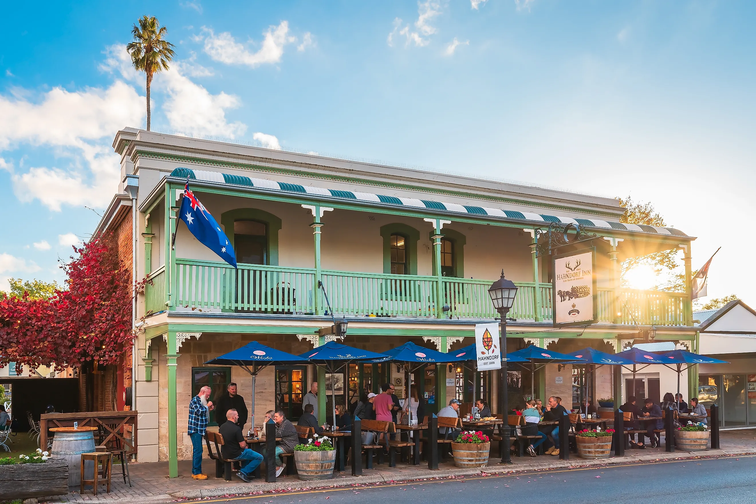
Main Street Hahndorf is lined with stone buildings, timber facades, and traditional German bakeries. The effect gives this Adelaide Hills town an appearance that reflects the community's origins. Hahndorf was established by Prussian Lutheran immigrants in 1839 who developed this settlement around farming, with Main Street eventually becoming the commercial heart of the locality as the road through the Adelaide Hills brought an influx of travellers through the district. Many of the buildings that are currently accommodated by shops and restaurants retain the same elements reminiscent of their historical architecture and heritage.
Alongside the visual experience, there is more than enough variety within the area to walk through without a fixed itinerary. Hahndorf Academy combines exhibitions and local galleries with work by South Australian artists, making it a vibrant regional centre for the arts. Food is another major draw. The Hahndorf Inn, The German Arms Hotel, and other historic pubs along the street serve the German cooking the town is known for, blending the traditional German tavern with the warmth of an Australian country pub.
Mount Barker Road, Stirling

More reminiscent of a country village than a typical commercial strip, Mount Barker Road is filled with large trees and garden beds that divide and soften the roadway while the surrounding hills close in the view. Stirling itself was founded in 1854, and much of the aforementioned greenery reflects the town's history as a cool-climate retreat for nearby settlers, who began building homes and gardens in the area shortly thereafter. The Stirling Hotel is one of the clearest reminders of that earlier era. It began life as the Halfway Inn, named for its position midway between Adelaide and Mount Barker, and it stood on the road when coach horses were still changed here.
Contemporary boutiques, cafes, and specialty retailers now give the road a more modern feel. The Stirling Village streetscape still provides green space for the public to linger in, much as the early settlers did. Seasonality plays a major role in the area's appeal, with the liquidambars and other deciduous trees along the main street turning through April and May, making Mount Barker Road especially photogenic when the foliage changes. Woorabinda Bushland Reserve, within walking distance of the main street, gives visitors somewhere to take that seasonal colour in at length.
Murray Street, Gawler

From the moment Gawler appeared on the map, Murray Street was its commercial heart. Laid out in 1839, this street quickly became the principal route through which inhabitants moved through the settlement. It connected the agricultural districts to the north with the Barossa and Clare Valleys and the routes toward the Murray River. In the decade following its founding, hotels, bakeries, and shoemakers gathered along the street. Much of that commercial heritage is still visible today. The Historic Main Street Walking Tour provides a systematic way of observing this heritage and the architecture created in tandem with it, but there is still plenty of opportunity for active self-exploration within the district.
The Gawler Cultural Heritage Centre occupies the historic civic hub of the locale and regularly hosts cultural events and activities, but there are several other landmarks that immerse visitors directly into places and scenes that the original settlers produced. An example is the Old Telegraph Station Museum, built in 1860 to a Colonial Architect design and still one of the plainest surviving pieces of early South Australian infrastructure. Another is Essex House, a two-storey landmark built in 1905 for the draper Alfred Sheard.
Church Street, Penola

Instead of slowly revealing its heritage, this main street in Penola immediately showcases its history in the form of a tall bronze statue standing right outside of the town's most recognisable buildings. Church Street has managed to retain much of the architecture from Penola's early development, including banks, churches, galleries, and specialty shops. The Walk with History route connects these places with Petticoat Lane, where cottages dating to the 1850s stand alongside a public heritage rose garden.
The Alexander Cameron Statue stands right next to the Royal Oak on Church Street, commemorating the Scottish pastoralist who arrived in the territory in 1844 and built the first Royal Oak Hotel four years later, in 1848. Now serving local produce and wines from the surrounding Coonawarra region, this establishment highlights the town's ability to modernise while still holding on to its historical roots.
First Street, Ardrossan

Ardrossan emerged as an agricultural and maritime hub in the 1800s, with the jetty of 1876 carrying wheat out to waiting ketches on Gulf St Vincent. First Street developed rapidly as the primary social and economic spine of the pioneer community. The grain silos that still dominate the skyline north of the town date to 1952, when Ardrossan became the first port in South Australia to handle bulk wheat, a distinction that cemented the town's standing as an agricultural centre.
First Street is also known for its food, with baking the local speciality. Ardrossan Bakery serves Cornish pasties, sausage rolls, and other local staples, and is part of a long line of bakeries whose menus reflect the eating habits of the district. Murals and mosaics add a visual dimension nearby. One large work on the wall of the Men's Shed covers the area's mining, farming and industrial history. Another, painted beneath the bridge by students of the Ardrossan Area School, turns the walkway into an underwater scene.
Bay Street, Port Broughton

This road tells the story of a town built around transporting goods, as it was once closely tied to the local railway and wheat trade. Originally, this road carried traffic between the narrow gauge line from Mundoora and the Port Broughton Jetty. The line opened in 1876, and the main street took on the practical role of shortening the path between the two. Today, this railway has disappeared, but Bay Street remains the town's core commercial precinct.
Cafes, shops, butchers and hairdressers now fill the street, replacing much of the activity once tied to freight and rail. The Port Broughton Hotel is one of the commercial centre's main landmarks, built around 1910 and since restored, and it looks across the park to the water. More about this site and others in the area can be found at the nearby Port Broughton Heritage Centre on Edmund Street, housed in the old school building and open by appointment. That past remains present in structures like the Port Broughton Jetty, once an integral piece of the district's transport infrastructure and now used for fishing and other recreation.
George Street, Moonta

Copper made Moonta rich, and this street still showcases the effect. The town grew rapidly after the mineral was discovered in the district in 1861. It began to draw workers and merchants, and then banks, hotels, and other infrastructure that made it one of the most important mining communities on the Yorke Peninsula. Much of the commercial architecture of the time that exists in the area to this day was established between 1863-1875, and the Discovering Historic Moonta Town Walk aids visitors in unpacking the heritage synonymous with these structures.
Moonta Town Hall, where the tour begins and ends, went up in 1885 at the height of the region's mining boom. It carries a grand public hall and council chambers, and today it also holds the town's gallery and cinema. On the corner outside stands the Moonta Historic Drinking Fountain, presented by Mayor John Symons in 1890 to mark the arrival of a reticulated water supply. George Street has the architectural scale of a settlement much larger than the local population can currently fill, but that contrast is part of its appeal. The grand commercial streetscapes simply showcase the once extraordinary economic prowess of this seemingly inconsequential copper mining settlement.
Main Street, Peterborough

For much of this town's history, the railway was the most important part of the locale. Rail lines converged on the settlement and brought passengers, workers, and freight through what eventually became a major transport center in South Australia. Main Street developed alongside that railway economy. Remnants of the era remain visible in the town's architecture and its attractions to this day. A railway carriage parked on the street is not an ordinary sight, which is exactly why the Town Carriage Museum works as well as it does. This restored first-class carriage holds exhibits on Peterborough's railway history, and screens set into the compartment windows play a virtual journey toward Broken Hill at the pace of a steam train.
The nearby Bob the Railway Dog statue commemorates a beloved railway character, while the town's heritage walk leads visitors through more of its historic core, with Main Street itself being part of the attraction. Beyond that, the Social History Museum (also known as the old YMCA building) provides an intimate look into early pioneer life through various collections and displays, including a replica of the original Petersburg Railway Station.
Murray Street, Tanunda

At one point, Murray Street was not actually considered the centre of Tanunda. Goat Square once served as the gathering place where early settlers often exchanged goods and news, with three original settler cottages still surviving around its edges. As the town developed, however, commercial activity shifted toward Murray Street primarily due to the evolution of regional transport and the physical merging of pioneer settlements that were once separate. Local entrepreneurs and civic leaders followed, placing their major infrastructure on Murray Street. The Alliance Hotel was licensed there by 1848, the Tanunda Telegraph Station followed in 1865 and the Tanunda Institute in 1879. Together, they locked the street into place as the town's civic and economic center.
Today, Murray Street remains a thriving main street, packed with businesses and history. The town's former post office and telegraph building now houses the Barossa Museum, which preserves the German-Lutheran pioneer history of the valley through folk art, early farming implements, and household collections. Tabor Lutheran Church has stood further along Murray Street since 1850 and is another example of a historical building still in its original use. The area is also known for the underground wine vaults dug before modern refrigeration, and cellars such as Underground Barossa host fortified wine and Muscat tastings that connect visitors to the craftsmanship of the settlers who built the town.
The Liveliest Streets In South Australia
These main streets in South Australia earned their reputations long ago and have maintained their standing as the heart of the towns they serve. Murray Street in Gawler is lined with shops, markets, and civic events, while George Street in Moonta houses the town's gallery and cinema in one grand building. In Ardrossan, First Street has a bakery turning out Cornish pasties and murals covering the walls a few doors away. These are the streets where South Australia has always come alive, still busy with the everyday business of towns that choose to gather in one place.