10 Most Overlooked Arizona Towns For 2026
The Arizona road trip runs on momentum. You pick a destination worth the drive, a canyon or a national park or a border crossing, and everything between the start and the finish blurs into a windshield. That blur hides a lot. A jail blasted into a cliff, a hotel lobby paved in Italian marble, a million gallons of ocean sealed under desert glass: all of them sit a few hundred feet off roads built to keep you moving. In each of the 10 towns below stands a landmark that would draw a crowd in a bigger place. What they lack is a reason to tap the brakes, so here are ten.
Patagonia, Arizona

Most drivers on State Route 82 are headed for Nogales and the border, and the grassland town they pass deserves a longer look. Patagonia sits at about 4,050 feet along Sonoita Creek, one of the few streams in southern Arizona that runs year-round, cradled between the Patagonia and Santa Rita mountains. That water is the reason for the birds. At the Nature Conservancy's Patagonia-Sonoita Creek Preserve, roughly 865 acres on the edge of town, a tall gallery forest of Fremont cottonwood and Goodding willow lines the creek, and more than 200 bird species have turned up in it, some found almost nowhere else in the United States. A mile away, the Tucson Audubon Society runs the Paton Center for Hummingbirds, where the feeders stay full for anyone who pulls up a chair, and it costs nothing to sit and watch. The old downtown along the highway is lined with galleries, a saloon, and a town park shaded by tall trees. Patagonia Lake State Park lies a short drive south for boating and more birding. Only about 800 people live here, in one of the prettiest corners of the state.
Window Rock, Arizona

Since 1936, the Navajo Nation has governed itself from Window Rock, on the eastern edge of the reservation hard against the New Mexico line. The name belongs to a sandstone arch, and the Navajo Nation Veterans Memorial sits in the ground beneath it: a circular path modeled on a medicine wheel, a statue of a code talker, and 16 angled steel pillars above a wall of veterans' names. A short drive along State Route 264 reaches the Navajo Nation Zoo and Botanical Park, home to animals native to Navajo country and the only zoo in the United States that a tribe manages. Admission runs on donations. Curators change the Navajo Nation Museum's themes often enough that a second visit rarely repeats the first, and weavers and silversmiths sell through the tribe's own retail operation a short walk away. Roughly 2,500 people live here, though the weekday count climbs into the thousands as the government offices fill.
Holbrook, Arizona

Petrified Forest National Park is the reason most people are on this stretch of highway at all, and Holbrook is the turnoff they skip on the way to it. That is a poor trade for a town this odd. Old Route 66 still runs through the middle of it as Hopi Drive and Navajo Boulevard, and the Wigwam Motel rents rooms inside white concrete teepees, with vintage cars parked at the doors. A block over, the Navajo County Historic Courthouse went up in 1898 and served as the county's justice hub for 78 years before it reopened as a free museum built around the original jail cells. Staff there hand out a walking-tour map, and on summer evenings, Indigenous dancers perform on the lawn out front. Then there is the Rainbow Rock Shop, its petrified wood displayed behind a yard of homemade dinosaurs painted in colors no dinosaur ever wore. All of this belongs to about 4,900 people who watch the rest of the traffic aim for the park.
Lake Havasu City, Arizona

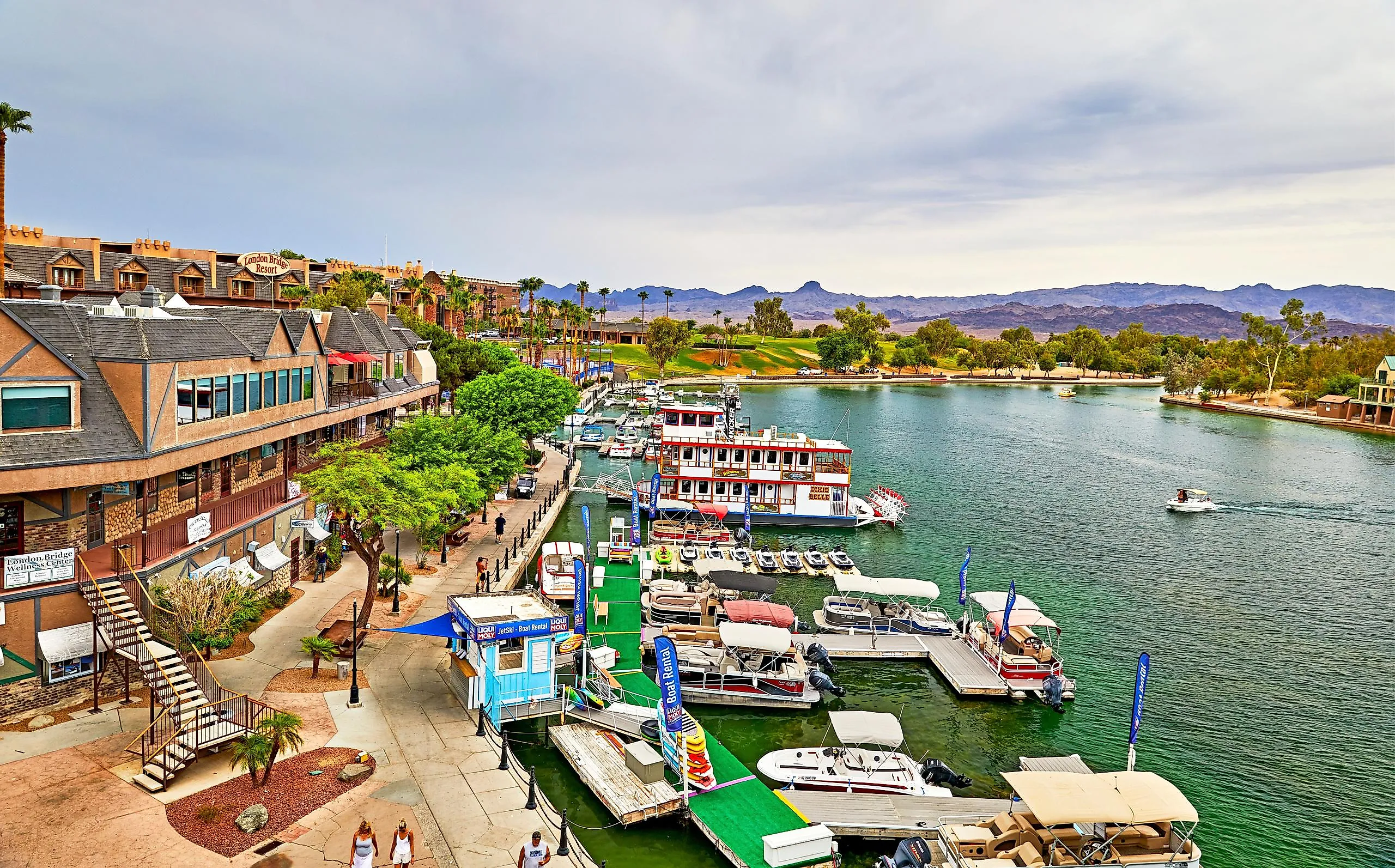
The strangest sight on State Route 95 is a piece of London. The original London Bridge spanned the Thames from 1831 until the City of London put it up for sale, and in 1968 the industrialist Robert McCulloch bought it, shipped its granite facing across an ocean and a continent, and had the stones re-hung over a channel in the Arizona desert. The bridge reopened in 1971 as the centerpiece of the planned town McCulloch was building on the eastern shore of Lake Havasu, a Colorado River reservoir behind Parker Dam. Crews dredged the Bridgewater Channel beneath it and raised a mock English Village alongside, red telephone boxes and all. Boaters treat the lake as the main event, running its 60 miles of open water past the bridge without a second look, which is a strange fate for the largest antique ever moved. About 57,000 people live here now, most of them drawn by the water and the winters rather than the masonry that put the place on the map.
Clifton, Arizona

The Coronado Trail winds through roughly 100 miles of switchbacks on the climb into the White Mountains, and Clifton sits where that byway ends, wedged into a narrow Greenlee County canyon. Most drivers see the town only because the road runs out there. Those who stop get Chase Creek Street, one of the state's best surviving runs of Territorial-period storefronts, where a printed walking tour ties each building to the family that raised it. The Greenlee County Historical Museum is housed in a 1913 fraternal hall down the row. A block away on Coronado Boulevard, workers blasted the Clifton Cliff Jail straight into the rock face in 1881; both cells stay open to anyone willing to step inside, and a Porter steam locomotive that once hauled ore sits alongside. On second Saturdays through the summer, the town's roughly 3,900 residents close the street for music and food.
Douglas, Arizona

Copper smelting built Douglas up on the Mexican border in the early 1900s, and the surest proof still stands in the lobby of the Gadsden Hotel, where a broad marble staircase rises beneath a vaulted ceiling that most guests find by accident. The same room holds the Wall of Faces, a community-built tribute to hundreds of Douglas residents who served during the Vietnam War era, and the Saddle and Spur Tavern opens off one side. Outside, a long line of early-1900s commercial buildings stands along G Avenue, saved because nothing ever came along to replace them. Out on the Geronimo Trail, the restored adobe headquarters of the old San Bernardino Ranch survives as Slaughter Ranch, where the lawman Texas John Slaughter once worked cattle across country that has changed little since. For the rest of the story, the exhibits at the Douglas-Williams House downtown trace how copper and a border crossing raised a city of about 16,500 on the international line.
Benson, Arizona

In 1880, Southern Pacific track reached the San Pedro Valley, and Benson became a transfer point where passengers swapped trains for stagecoaches bound for the mining camps. The traffic moves on Interstate 10 now and rarely slows. Ten miles south, in the Whetstone Mountains, Kartchner Caverns State Park is built around a cave that is still wet and still growing, so tour groups move under tight humidity control and reservations matter. At the park's Discovery Center, a theater and a museum help fill the wait, and a hummingbird garden sits off the patio. The San Pedro River flows north out of Mexico through the same valley, a corridor that stayed largely undeveloped, and birders come out for it through spring and fall migration. In town, the visitor center's displays cover the Butterfield Overland stage route and the railroad decades that followed, and a local museum has rotating art and history shows for the roughly 5,300 residents and whoever else pulls off the interstate.
Oracle, Arizona

At about 4,500 feet in the northern foothills of the Santa Catalinas, saguaro gives way to oak and grassland, and Oracle sits in that transition. Biosphere 2 stands just up the road: three acres of glass and steel enclosing a rainforest, a savanna, a coastal fog desert, and a million-gallon ocean. The University of Arizona has run it as a research campus since 2011, and self-guided tours go out most days of the year. Oracle State Park covers 4,000 acres of wildlife refuge below the peaks, centered on the Kannally Ranch House, a 1932 Mediterranean Revival home hung with some 30 paintings by the cowboy artist Lee Kannally. The park holds International Dark Sky status, designated in 2014, and rangers schedule star parties through the seasons. Passage 13 of the Arizona National Scenic Trail crosses the same ground on its long run between Mexico and Utah, and a local zipline outfit will even collect hikers off the trail and put them up in a cabin overnight. Fewer than 4,000 people live in the middle of all of it.
Gila Bend, Arizona

A flying saucer sits on the roofline of the Space Age Lodge, and that is what makes a few Interstate 8 drivers brake at Gila Bend, the elbow where the Gila River turns west across the desert. The owners have run the coffee shop all the way into the theme, and they have worked this highway for decades. Northwest of town, hundreds of images cover a jumble of volcanic boulders at the Painted Rock Petroglyph Site, most pecked by Hohokam and other Indigenous peoples, with later inscriptions added by passing travelers; the Bureau of Land Management maintains interpretive panels and a small campground there. A single room at the Gila Bend Visitor Center and Museum on West Pima Street holds Hohokam pottery and stagecoach-era history. Farther out, the Sonoran Desert National Monument stretches across a long sweep of saguaro forest and rugged ranges in the Sonoran Desert. Not bad for a town of fewer than 1,900.
Ajo, Arizona

Most traffic on State Route 85 heads straight through Ajo toward Organ Pipe Cactus National Monument or the Mexican beaches at Puerto Peñasco, two hours south. The community of about 3,000 is the stop nobody plans. At the center of it sits the Ajo Plaza, a Spanish Colonial Revival town square built in 1917, its white arched buildings and shaded park flanked by two mission-style churches from the 1920s. The New Cornelia Copper Company laid the whole town out around that plaza, and the buildings entered the National Register of Historic Places in the late 1990s. A short walk away stands the 1919 Curley School, once the mining families' schoolhouse and now live-work lofts for artists, its Spanish Colonial lines matched to the plaza's. The copper mine that paid for all of it closed in 1985, but the New Cornelia pit, more than a mile wide, still opens up below a lookout on the edge of town. A few blocks over, murals and sculpture line Artist Alley, laid out for a self-guided walk.
Ten Reasons To Tap The Brakes
The common thread is the road. Every one of these towns sits beside a highway engineered to carry people somewhere else, and in each one something survives that would outsize a bigger place: a cliff jail, a marble lobby, a glass ocean, a sandstone arch above a tribal capital. The bigger destinations draw their crowds for good reason, and none of these ten is a replacement for them. What they need from a traveler is smaller than that. The exit is marked, the parking is free, and the landmark is right there once you slow down enough to see it.