Maps of Mississippi
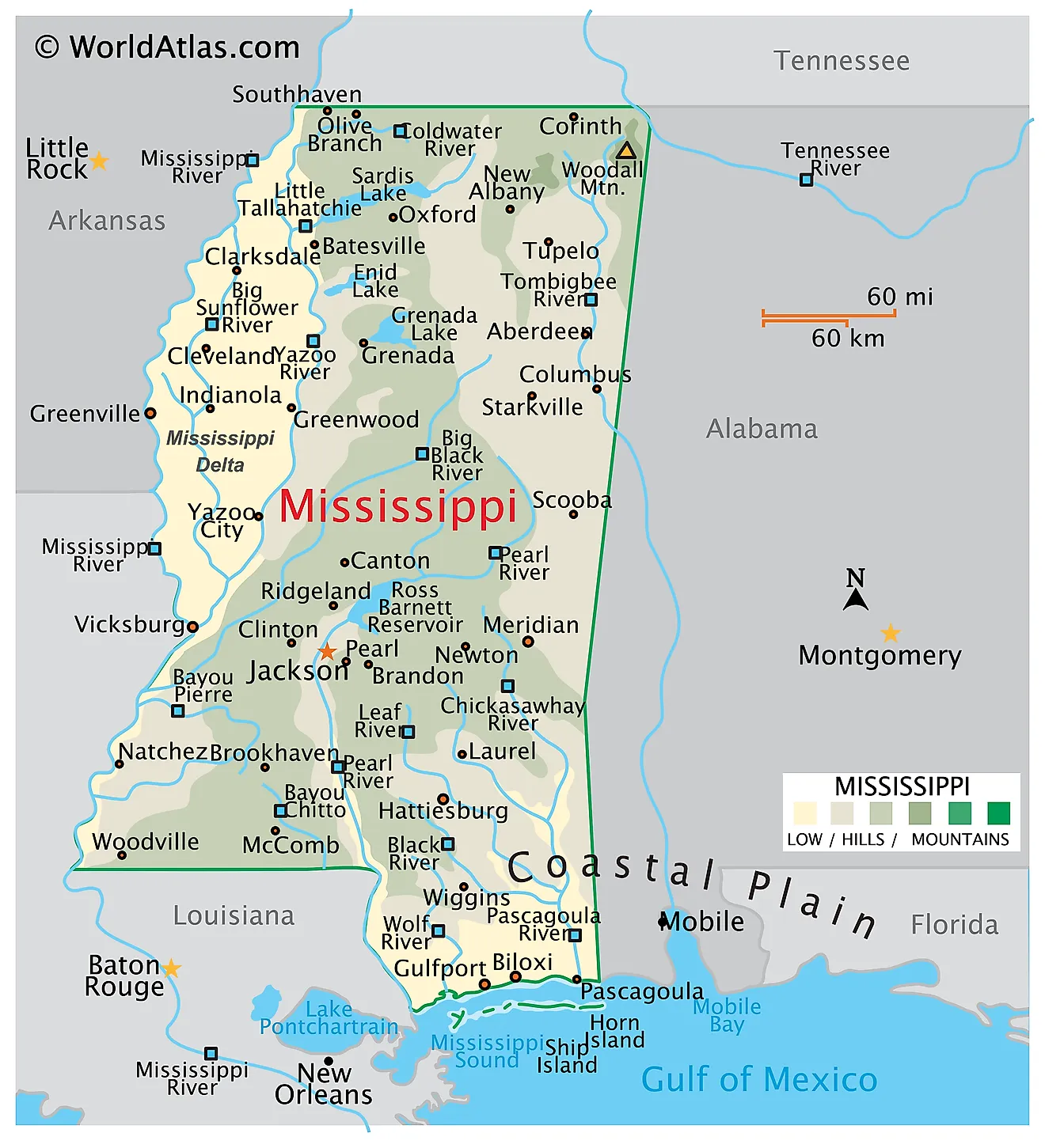
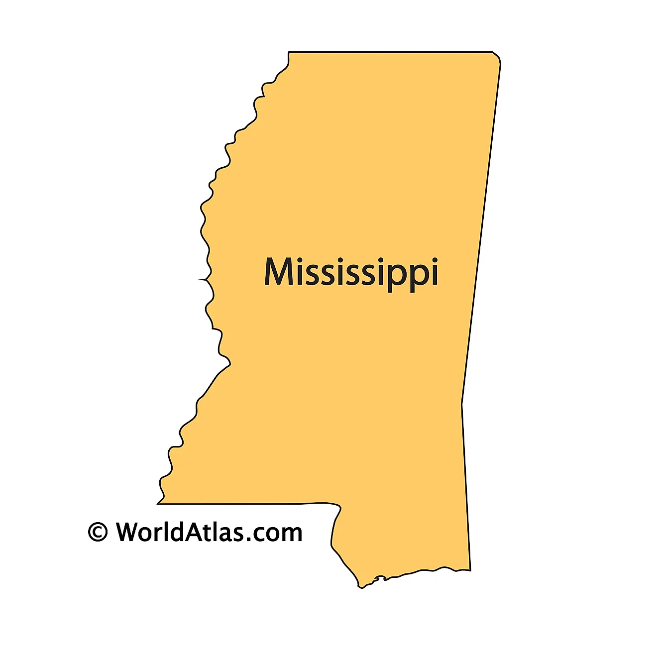
Mississippi is a state in the southeastern United States. It shares its borders with Tennessee to the north, Alabama to the east, the Gulf of Mexico to the south, and Louisiana and Arkansas to the west, where the boundary follows the Mississippi River. The state covers approximately 48,432 square miles (125,438 square kilometers), making it the 32nd largest state.

Mississippi is one of the flattest states in the country. Its highest point reaches only 806 feet, the fourth lowest high point of any state, and the land slopes gently and almost continuously from the northeastern corner down toward the Mississippi River on one side and the Gulf on the other. Because the relief is so subdued, the state's geography is defined less by elevation than by soil: bands of sand, clay, chalk, silt, and alluvium laid down by ancient seas and rivers, each supporting a distinct landscape.
Where Is Mississippi?

The state measures about 339 miles from north to south and 171 miles from east to west. Its eastern boundary with Alabama is largely a surveyed line, its northern boundary with Tennessee follows the 35th parallel, and its western boundary is the meandering channel of the Mississippi River — a border that has shifted repeatedly as the river cut new channels, leaving small pockets of Mississippi land stranded on the Arkansas and Louisiana sides.
With roughly 2.95 million residents, Mississippi is the 35th most populous state. Jackson, near the center of the state on the Pearl River, is both the capital and the largest city. The state is divided into 82 counties, and unusually, ten of them have two county seats apiece — a legacy of river and terrain barriers that once made a single courthouse impractical.
Mississippi's Natural Regions

Geographically, Mississippi divides into two unequal parts: the Mississippi Alluvial Plain in the northwest, and the East Gulf Coastal Plain covering everything else. The Coastal Plain is conventionally subdivided into ten smaller regions, giving eleven in total. Arranged roughly from west to east and north to south, they are:
- Alluvial Plain — the Delta, in the northwest
- Loess Hills — the bluff belt along the Delta's eastern edge and the river's east bank
- North Central Plateau — rolling hills across the north-central interior
- Pontotoc Ridge — a narrow upland ridge in the northeast
- Flatwoods — a thin band of poorly drained clay flats
- Black Prairie — dark chalk-derived soils along the northeastern border
- Tombigbee and Tennessee River Hills — the rugged far northeast
- Paleozoic Bottoms — the small northeastern corner with the state's oldest exposed rock
- Jackson Prairie — a prairie belt through the center of the state
- Southern Pine Hills — the Piney Woods of the southern third
- Coastal Meadows — the low, marshy strip along the Gulf
These regions run in broad northwest-to-southeast bands, and that alignment is not accidental: each marks a former shoreline of the Gulf of Mexico from a period when the sea reached far inland.
The Alluvial Plain: The Delta

The Mississippi Alluvial Plain occupies the state's northwest and is known everywhere as the Delta. An important clarification: this is not the delta of the Mississippi River. That birdfoot delta lies far to the south, in Louisiana, where the river meets the Gulf. Mississippi's Delta is an inland floodplain, properly called the Yazoo Basin, lying between the Mississippi River on the west and the Yazoo River and the loess bluffs on the east.
It runs roughly 200 miles from just below Memphis south to Vicksburg, where the Yazoo joins the Mississippi, and reaches about 87 miles across at its widest. Writer David Cohn captured its extent memorably, describing it as beginning in the lobby of the Peabody Hotel in Memphis and ending on Catfish Row in Vicksburg. It does not extend to the Gulf of Mexico.
The land is extraordinarily flat, dropping only from about 205 feet near Memphis to 80 feet at Vicksburg across that entire span. Thousands of years of Mississippi River flooding laid down deep black alluvial soil that ranks among the most fertile in the world, supporting cotton, soybeans, rice, and catfish farming. More than 200 miles of levees now protect the basin, and the region's cultural output — it is widely regarded as the birthplace of the blues — is as significant as its agriculture.
The Loess Hills

Along the eastern edge of the Delta, and continuing south along the Mississippi River, runs a belt of hills 5 to 15 miles wide capped with loess — fine, wind-blown silt deposited during the Ice Ages when dust blew off the glacial outwash plains of the river valley. Loess has an unusual property: it holds vertical faces when cut, so roads and streams carve steep-walled gullies through it, and the bluffs above the river stand sharply.

Vicksburg National Military Park in Mississippi.
The deposit is thickest right at the bluff line and thins rapidly eastward. Vicksburg and Natchez both sit on these bluffs, and their commanding positions above the river shaped their history — the heights at Vicksburg made the city the strategic key to the Mississippi during the Civil War.
The Northeastern Hills

Mississippi's northeastern corner holds its most rugged country. The Tombigbee and Tennessee River Hills occupy a strip about 120 miles long along the Alabama border, where sandstone-capped hills give the landscape more relief than anywhere else in the state. Woodall Mountain, near Iuka in Tishomingo County, rises to 806 feet (246 meters) — the highest point in Mississippi and the 47th highest state high point in the country.
Tucked into the far corner are the Paleozoic Bottoms, a small area where erosion has exposed rock from the Paleozoic era, hundreds of millions of years older than anything else at the surface in Mississippi. Everywhere else the bedrock is comparatively young marine sediment.

Running southwest from this corner is Pontotoc Ridge, a narrow cuesta — a ridge with a steep face on one side and a gentle slope on the other — formed where a resistant layer of sand and marl outcrops. It stands noticeably above the lowlands on either side and carries oak and hickory forest.
The Prairies and Central Uplands

Four regions occupy the middle of the state. The North Central Plateau, sometimes called the North Central Hills, is the largest: a broad expanse of gently rolling, forested hills on sandy and clay soils, taking in Oxford and much of the interior north.
The Black Prairie, or Black Belt, sweeps along the northeastern border in a crescent that continues into Alabama. Its name comes from the dark, sticky soil formed by the weathering of Selma Chalk, a soft marine limestone deposited when the region lay beneath a Cretaceous sea. The chalk is rich in calcium and produced tallgrass prairie rather than forest — and, later, some of the state's most intensively farmed cotton land.
Between the Black Prairie and the North Central Plateau lies the Flatwoods, a narrow band rarely more than a few miles wide, underlain by heavy clay that drains poorly and supports dense, scrubby woodland. Farther south, the Jackson Prairie forms a similar belt across the center of the state near the capital, underlain by the calcareous clays and marls of the Jackson Group. Both prairies interrupt the otherwise forested landscape for the same reason: their soils are too heavy and alkaline for the pines that dominate elsewhere.
The Southern Pine Hills

The Southern Pine Hills, universally called the Piney Woods, cover the southern third of Mississippi — a far larger share of the state than the southeastern corner alone. This is rolling to hilly country on deep sandy soils, cut by countless creeks and rivers flowing south toward the Gulf.
Longleaf pine once dominated here in open, fire-maintained savanna. Heavy logging between the 1880s and the 1930s removed most of it, and the replanted forest today is largely loblolly and slash pine grown for timber and pulp. Mississippi is now roughly 65% forested, one of the highest proportions of any state, and forestry ranks among its largest industries. The De Soto National Forest protects a substantial block of this country.
The Coastal Meadows and Barrier Islands

A narrow strip of flat, low-lying land — the Coastal Meadows — runs along the Gulf, rarely more than 20 miles deep. Salt marsh, wet pine savanna, and tidal bayou dominate, with salt-tolerant grasses in the wettest ground. The state's lowest point is sea level along this shore.
Mississippi does not front the open Gulf directly. Instead it faces the Mississippi Sound, a shallow lagoon roughly 10 miles wide, sheltered behind a chain of barrier islands.

Ship, Horn, Petit Bois, Cat, and Round Islands lie some 8 to 12 miles offshore and absorb much of the Gulf's wave energy before it reaches the mainland. Most are protected within Gulf Islands National Seashore. These islands are not fixed: they migrate steadily westward as currents move sand along their length, and Hurricane Camille split Ship Island into two pieces in 1969 — a breach that remained open until it was artificially closed in 2019.
Rivers

The Mississippi River forms the state's entire western border. Everything in Mississippi ultimately drains either west into it or south into the Gulf, with a divide running roughly through the center of the state.
On the western side, the Yazoo drains the Delta for about 190 miles before joining the Mississippi at Vicksburg — a textbook example of a "yazoo stream," a tributary forced to run parallel to a larger river because natural levees block it from joining sooner. The Big Black River drains the central-west, and the Tallahatchie and Yalobusha meet to form the Yazoo near Greenwood.
Flowing south to the Gulf are the Pearl, which passes Jackson and forms part of the Louisiana border, and the Pascagoula. The Pascagoula is notable well beyond Mississippi: it is the largest river system in the lower 48 states with no dams or major impoundments along its main stem. In the northeast, the Tombigbee flows south into Alabama, and a short stretch of the Tennessee River clips the state's far northeastern corner.
Lakes and Reservoirs

Mississippi has no large natural lakes. What it has instead are two distinct kinds of water body. The first is the oxbow lake — a crescent-shaped remnant of an abandoned river meander, cut off when the Mississippi shifted channel. Hundreds dot the Delta, including Lake Washington, Moon Lake, and Eagle Lake, and they are the state's only natural standing water of any size.
The second is the reservoir. The Ross Barnett Reservoir on the Pearl River, just northeast of Jackson, is the largest body of water entirely within Mississippi at roughly 33,000 acres, created in 1963 to supply the capital with drinking water.

Four large flood-control reservoirs sit along the eastern rim of the Delta, built by the Army Corps of Engineers to hold back runoff from the hills before it reaches the Yazoo Basin: Sardis, Enid, Grenada, and Arkabutla. Grenada is the largest of the four at high water.
Climate

Mississippi has a humid subtropical climate throughout, with long, hot, humid summers and short, mild winters. There is no mountain barrier anywhere in the state and no significant elevation change, so conditions vary little from one region to another — the main gradient is simply that the south is warmer and wetter than the north.
Annual precipitation ranges from around 50 inches in the north to more than 65 inches on the Gulf Coast, among the wettest in the continental United States. Snow is rare and mostly confined to the northern counties.
Two hazards define the state's weather. Tropical systems strike the coast regularly; Hurricane Katrina came ashore near the Mississippi–Louisiana line in August 2005 and produced a storm surge exceeding 25 feet along the Gulf Coast, the highest ever recorded in the United States. Inland, Mississippi sits in the corridor sometimes called Dixie Alley, which sees frequent and often nocturnal tornadoes, particularly in spring and late autumn.
Mississippi Geography at a Glance
| Feature | Detail |
|---|---|
| Total area | Approx. 48,432 sq mi (125,438 sq km) — 32nd largest state |
| Dimensions | Approx. 339 mi north-south; 171 mi east-west |
| Highest point | Woodall Mountain, 806 ft (246 m), Tishomingo County |
| Lowest point | Gulf of Mexico, sea level |
| Bordering states | Tennessee, Alabama, Louisiana, Arkansas |
| Western border | Mississippi River |
| Natural regions | Eleven, within two provinces: the Alluvial Plain and the East Gulf Coastal Plain |
| Forest cover | Approx. 65% of the state |
| Largest inland water body | Ross Barnett Reservoir, approx. 33,000 acres |
| Counties | 82 |
| Capital and largest city | Jackson |
Counties Map
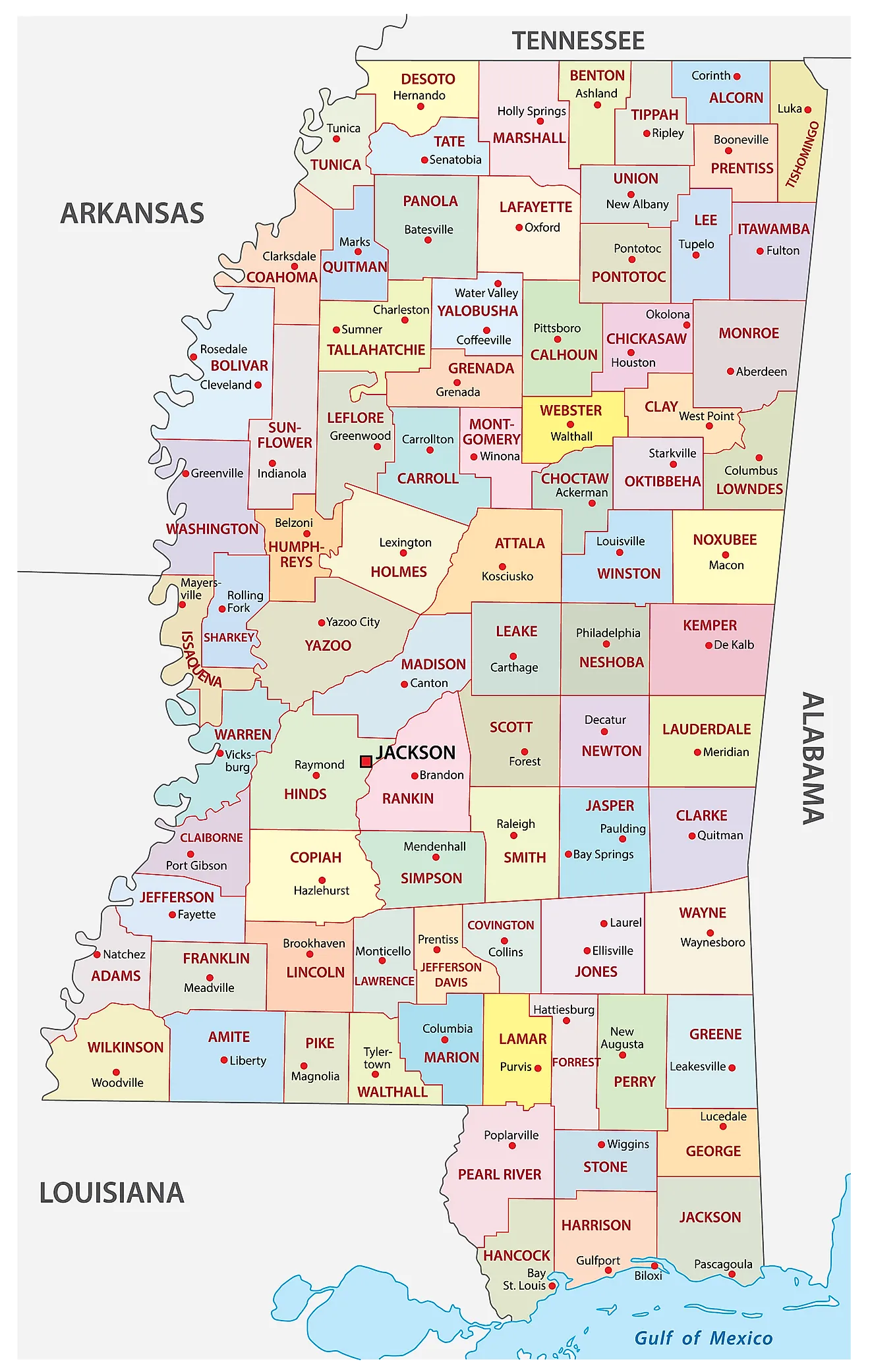
The State of Mississippi is divided into 82 counties. In alphabetical order, these counties are: Adams, Alcorn, Amite, Attala, Benton, Bolivar, Calhoun, Carroll, Chickasaw, Choctaw, Claiborne, Clarke, Clay, Coahoma, Copiah, Covington, DeSoto, Forrest, Franklin, George, Greene, Grenada, Hancock, Harrison, Hinds, Holmes, Humphreys, Issaquena, Itawamba, Jackson, Jasper, Jefferson, Jefferson Davis, Jones, Kemper, Lafayette, Lamar, Lauderdale, Lawrence, Leake, Lee, Leflore, Lincoln, Lowndes, Madison, Marion, Marshall, Monroe, Montgomery, Neshoba, Newton, Noxubee, Oktibbeha, Panola, Pearl River, Perry, Pike, Pontotoc, Prentiss, Quitman, Rankin, Scott, Sharkey, Simpson, Smith, Stone, Sunflower, Tallahatchie, Tate, Tippah, Tishomingo, Tunica, Union, Walthall, Warren, Washington, Wayne, Webster, Wilkinson, Winston, Yalobusha, and Yazoo.
With an area of 125,438 sq. km, the State of Mississippi is the 32nd largest and the 35th most populous state in the USA. Located mainly in Hinds County, with smaller portions extending into Madison and Rankin counties, is Jackson (officially, the City of Jackson) – the capital and most populous city of Mississippi. As the seat of state government, Jackson's economy is dominated by public-sector employment and healthcare, with the University of Mississippi Medical Center the largest employer in the state; manufacturing, food processing, and telecommunications also contribute. The city is built above the Jackson Volcano, an extinct Cretaceous volcano lying 2,900 feet beneath the surface under the Mississippi Coliseum, making Jackson the only US state capital situated atop a buried volcano.
Where is Mississippi?
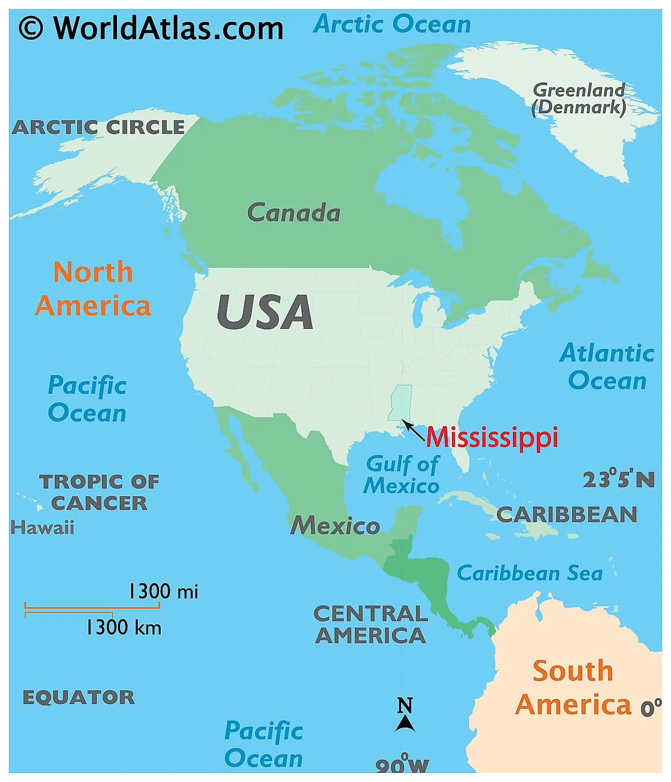
The State of Mississippi is located in the Gulf Coast region of the United States. Mississippi is bordered by the state of Tennessee in the north, by Arkansas in the northwest, by Alabama in the east, by Louisiana in the southwest, and by the Gulf of Mexico in the south. The Mississippi River flows along the state’s entire western border.
Regional Maps: Map of North America
Outline Map of Mississippi
Key Facts
| Legal Name | State of Mississippi |
|---|---|
| ISO 3166 Code | US-MS |
| Capital City | Jackson |
| Major Cities |
|
This page was last updated on September 17, 2026