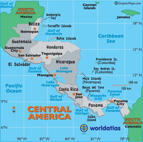
Location of Central America

Latitude: (shown as a horizontal line) is the angular distance, in degrees, minutes, and seconds of a point north or south of the Equator. Lines of latitude are often referred to as parallels.
Longitude: (shown as a vertical line) is the angular distance, in degrees, minutes, and seconds, of a point east or west of the Prime (Greenwich) Meridian. Lines of longitude are often referred to as meridians.
Central America Latitude and Longitude examples: (see map)
| Belmopan, Belize: | 17° | 15' | N | / 88° | 46' | W |
| Guatemala City, Guatemala: | 14° | 36' | N | / 90° | 32' | W |
| Managua, Nicaragua: | 12° | 8' | N | / 86° | 15' | W |
| Panama City, Panama: | 8° | 58' | N | / 79° | 32' | W |
| San Jose, Costa Rica: | 9° | 55' | N | / 84° | 4' | W |
| San Salvador, El Salvador: | 13° | 41' | N | / 89° | 11' | W |
| Tegucigalpa, Honduras: | 14° | 4' | N | / 87° | 12' | W |