Geography Statistics of Central America
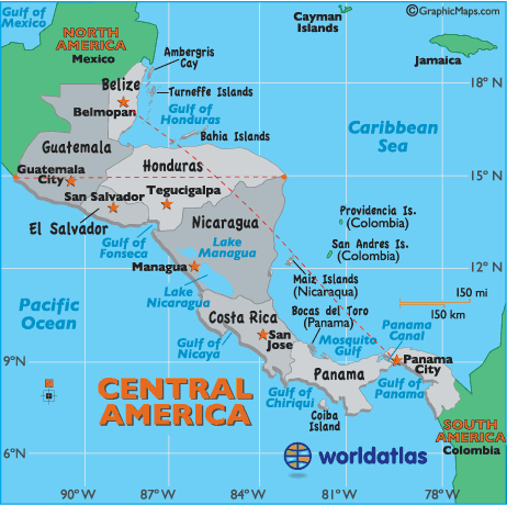
- Size: 523,780 sq km, 202,000 sq miles
- Percent of Earth's Land: 0.1%
- Highest Point: Tajumulco Volcano, Guatemala, 13,845ft (4,220m)
- Lowest Point: Caribbean Sea, 0ft (0m)
- Geographic Center: The geographic center of Central America is 116 miles northeast of Lake Managua, Nicaragua
- Horizontal Width: From Guatemala's southwestern border with Mexico, directly east to the Caribbean Sea border of Honduras and Nicaragua: 595 miles (958 km) (see map)
- Vertical Length: From Belmopan, Belize directly southeast to Panama City, Panama: 880 miles (1,416 km) (see map)
Note: Lengths and widths are point-to-point, straight-line measurements and will vary some using other map projections.
Central American Countries
(by LAND AREA):
- Nicaragua: 130,373 sq km
- Honduras: 112,090 sq km
- Guatemala: 108,890 sq km
- Panama: 78,200 sq km
- Costa Rica: 51,100 sq km
- Belize: 22,966 sq km
- El Salvador: 21,040 sq km
Central American Countries
(by POPULATION DENSITY)
- El Salvador: 292 per sq km
- Guatemala: 129 per sq km
- Costa Rica: 90 per sq km
- Honduras: 67 per sq km
- Nicaragua: 44 per sq km
- Panama: 44 per sq km
- Belize: 13 per sq km