Estuaries
An estuary refers to a partially surrounded coastal brackish water body with a free link to the open sea, and where the freshwater of the rivers and streams combines with the saltwater from the ocean. The term ‘estuary’ has been derived from the Latin word “aestuarium,” which means the “tidal inlet of the sea,” and has in turn been derived from the word “aestus,” which means “tide.” It is believed that most of the existing estuaries in the world were formed during the Holocene epoch, with the flooding of river-eroded valleys and the rise of sea level approximately 10,000 to 12,000 years ago. The mixing of freshwater and saltwater provides high levels of nutrients in the water column as well as in the sediment, making estuaries one of the most biologically productive and geomorphologically complex ecosystems in the world. Currently, various anthropogenic factors such as deforestation, overfishing, eutrophication, overgrazing, soil erosion, and the filing of wetlands have led to the degeneration of several estuaries.
Types Of Estuaries
Many distinctive types of estuaries can be categorized based on geomorphology and water circulation. The different types of estuaries based on geomorphology include:
Drowned River Valleys

Also referred to as “coastal plain estuaries,” drowned river valleys are formed where the seawater continuously penetrates into land resulting in the eventual occupation of coastal river valleys by the sea. This type of estuary is quite common in areas having a temperate climate. The width-to-depth ratio of drowned river valley estuaries is quite large, giving them a “wedge-shaped” appearance. The estuary gets further wide and deep as the distance from seawater reduces. Examples of drowned river valley estuaries include the United Kingdom’s Severn Estuary and the Chesapeake Bay, Delaware Bay, Galveston Bay, and Tampa Bay in the United States.
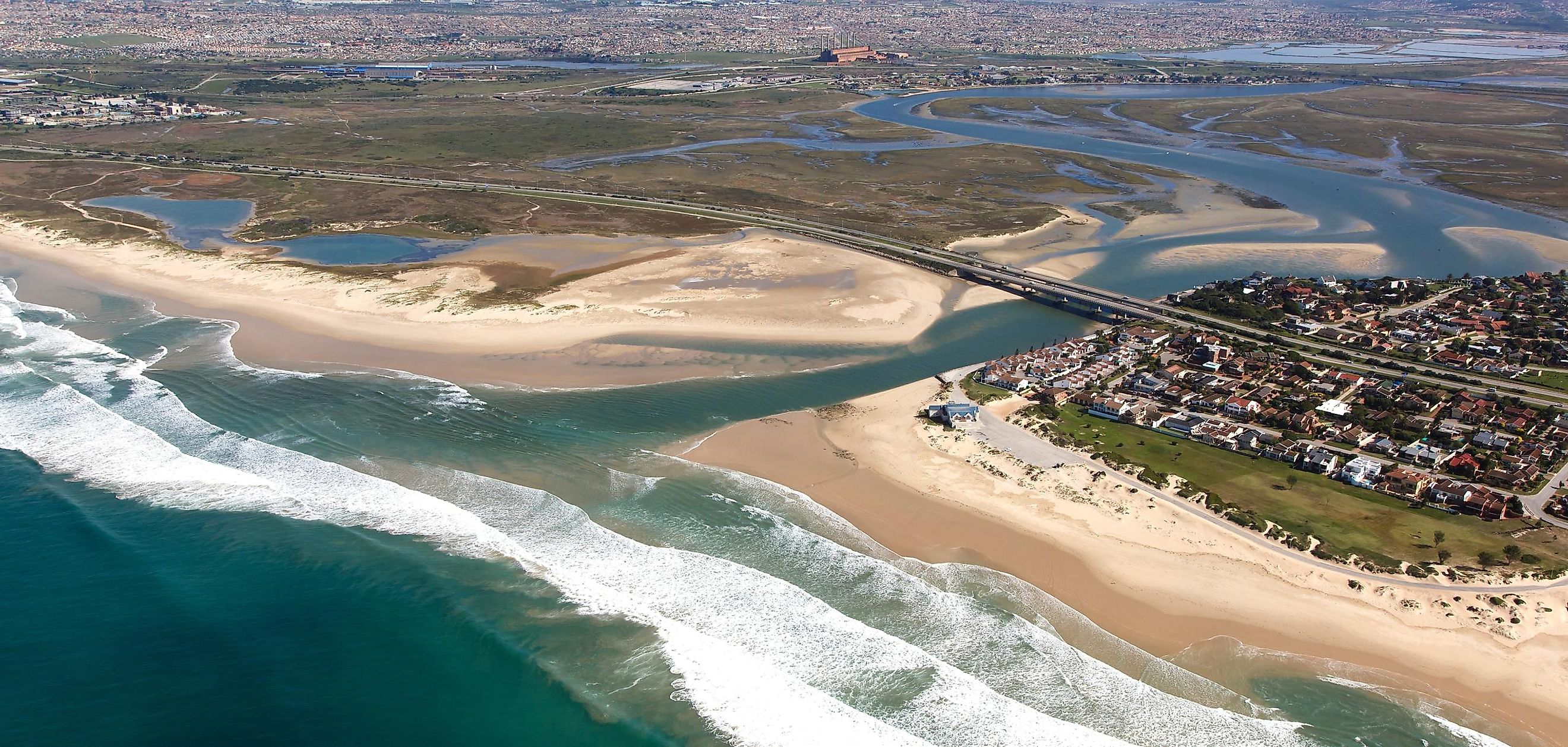
Bar-Built Or Lagoon-Type Estuaries

Bar-Built Estuaries are formed in tropical and subtropical places where the sediment deposition increases with rising sea levels, carving out shallow estuaries separated from the sea by barrier islands. The deposition of sediments also forms barrier beaches which partly cuts off the estuary and contain one or more narrow inlets that link it with the ocean waters. This type of estuary is quite common on gently sloping plains placed along the marginal sea coasts or close to the tectonically stable continental edges. North Carolina’s Pamlico Sound is an example of a bar-built or lagoon-type estuary.
Fjord-Type Estuary

Fjord-Type estuaries are formed in deeply eroded river valleys that have been deepened and widened by the Pleistocene glaciers. These U-shaped estuaries feature rocky bottoms, steep slopes, and underwater sills that glacial activities have figured through several centuries. The depth of this type of estuary exceeds 1,000 ft in the upper reaches, while they are pretty shallow close to their mouth where rocky bars and glacial moraines restrict water movement. Fjord-type estuaries are common along the coasts of eastern Canada, British Columbia, Puget Sound, Alaska, Iceland, Norway, Greenland, and New Zealand.
Tectonically Produced Estuaries

This type of estuary is formed due to land subsidence or breaking off from the ocean by the movement of land associated with landslides, volcanic eruptions, and faulting. It is to be noted that during the Holocene Epoch, the seawater inundation due to the rise in sea level caused by tectonic movements have led to the creation of this type of estuary. Less common than the above-mentioned types of estuaries, an example of such a tectonically produced estuary is the San Francisco Bay, created by the San Andreas fault’s crustal movements leading to the inundation of the lower portions of the San Joaquin and Sacramento rivers.
The different types of estuaries based on water circulation include:
Salt Wedge

In such estuaries, when the river output is more than the marine input, the tidal effects on the estuary are significantly reduced. The freshwater flows on the top of seawater in a layer that slowly thins out as it moves seawards. Along the bottom of the estuary, the comparatively denser seawater moves landward and forms a wedge-shaped layer that becomes thinner as it comes nearer to the land. With the development of a velocity difference between the two layers, shear forces produce internal waves at the seawater-freshwater interface. The Mississippi River estuary is an example of a salt-wedge estuary.
Partially Mixed Estuary Or Slightly Stratified Estuary

In this type of estuary, the river output is far lesser than the marine input with the increase in tidal forces. Significant turbulence is thus generated, which leads to the mixing of the entire water column and a more longitudinal variation of salinity. The Chesapeake Bay and Narragansett Bay are examples of partially mixed estuaries.
Well Mixed Estuary Or Vertically Mixed Estuary
In this type of estuary, the river output is exceeded by the mixing forces generated by the tidal action. The intense turbulence and eddy effects caused by this mixing result in a well-mixed water column with a complete loss of vertical salinity gradient. The lower portions of the Delaware River and New Jersey’s Raritan River are perfect examples of a well-mixed estuary.
Inverse Estuary

Inverse estuaries are formed in arid climates where the evaporation rate is much higher than the freshwater inflow. Both riverine and oceanic water flow near the surface and towards a maximum salinity zone. This water is then pushed downwards and moves along the base in both landward and seaward directions. South Australia’s Spencer Gulf is an example of an inverse estuary.
Intermittent Estuary
In this type of estuary, due to continuous fluctuations in freshwater supply to the estuary, the salinity level of intermittent estuaries varies widely.
Importance Of Estuaries

Estuaries are considered highly dynamic ecosystems, where conditions like temperature, turbidity, water flow, depth, and salinity all change daily in response to the tides. This dynamism is responsible for making the estuaries one of the Earth’s most highly productive habitats that serve as critical spawning grounds for many organisms, feeding stops for migratory and resident birds and natural water filters that help in maintaining water quality. The main primary producers of estuaries are phytoplankton like diatoms, dinoflagellates, blue-green algae, and green algae. The coastal waters of this ecosystem experience a strong seasonal variation in the number of fish communities. Hardy marine residents are found in winter, whereas various marine and anadromous fishes are found during summer. Examples of fish found in the estuaries include Pacific Herring, juvenile flatfish, surfperch, rockfish, lampreys, and anadromous salmonids.
In addition, estuaries are also equally important for humans. The estuaries provide habitat for both commercial and recreational fish and attract millions of tourists annually to enjoy various recreational activities like boating, swimming, surfing, fishing, and bird watching. Moreover, the estuaries act as a natural buffer between the land and the ocean and provide protection from storms and hurricanes. They create a natural barrier that absorbs the energy of the large waves generated by these storms, thereby minimizing loss of lives and property damage.
Degradation Of Estuaries

The proximity of estuaries to large urban centers has made them vulnerable to severe threats from water pollution due to industrial pollutants, agricultural runoff, and discharge of untreated sewage; overfishing of target fish stock, modification of estuarine catchments, expansion of urban and rural settlements; loss of habitat due to erosion and outdated agricultural practices; recreational pressures; and submergence of catchment areas due to rise in sea level caused by climate change.
Therefore, it is of utmost necessity to ensure the proper health of the estuaries, which are vital to the various plants, animals, and humans that call the estuaries their home and rely on them for their sustenance. Correct policies must be developed through collaborative research initiatives to tackle any changes in these unique ecosystems in the near future, and proper action must thereby be taken for the maintenance, restoration, and protection of the estuaries.


