This Oregon Scenic Byway Is The Road Trip Of A Lifetime
Oregon's Historic Columbia River Highway stretches about 74 miles between Troutdale and The Dalles, following the Columbia River Gorge past several attractions and waterfalls. Built between 1913 and 1922 and the first planned scenic roadway in the United States, it’s also the first American highway ever named a National Historic Landmark. Here’s how to turn a drive along what’s been called the “King of Roads” into an unforgettable Oregon road trip.
Showing Off Oregon’s Scenery

The highway all started when a Seattle businessman, Sam Hill, started campaigning for a paved route through the Columbia River Gorge that would rival the most scenic drives in Europe. He recruited Samuel Lancaster, an engineer from Tennessee who arrived in Oregon in 1908 to spend years exploring the terrain before a shovel ever went in the ground.
Lancaster surveyed for views first, and road alignment second. The job, he made it known, was to find the beauty spots, then locate the road so it reached them. And given that the route was to traverse the 80-mile-long, 4,000-foot-deep Columbia River Gorge, he had plenty of incredible views to work with.
Completed in 1922, the road is now on the National Register of Historic Places and has been named a National Historic Civil Engineering Landmark. National Historic Landmark status has also been applied, and it’s now one of Oregon's four All-American Roads, the top tier of the federal byways program. Although Interstate 84 had swallowed or bypassed most of the original route by the 1950s, surviving segments amount to an approximate 70-mile drive that takes from about three to five hours, depending on how many stops you make.
From Troutdale to Crown Point

Billed as the “Gateway to the Gorge,” the Historic Columbia River Highway adventure begins when you pull off Interstate 84 at exit 17 and start following the signs through Troutdale. You’ll soon cross Sandy River, where Lewis and Clark camped in 1805. Learn more about it at the Lewis and Clark State Recreation Site off exit 18.
From here, the highway follows the Sandy River upstream before climbing past orchards and blueberry fields and through Springdale and Corbett. The first proper look at the gorge comes at the Portland Women's Forum State Scenic Viewpoint at Chanticleer Point. The Chanticleer Inn once stood on this spot, and it was this view that convinced Sam Hill to build the highway.
Two miles on is the Vista House, the building most people picture when they think of this road. At 733 feet above the Columbia River on Crown Point, this curious-looking octagonal stone rotunda was built in 1918 as a memorial to Oregon pioneers, as well as a pit stop for travelers. Peek inside to see an artistic tribute in marble with the names of settler families.
The Waterfall Corridor

Multnomah Falls in the Columbia River Gorge Scenic Area, near Portland, Oregon.
To get down the 600-foot drop from Crown Point, you’ll have to tackle a series of figure-eight loops that wind their way down to the river. And it’s nothing short of spectacular. First up is Latourell Falls, a 224-foot plunge over columnar basalt that’s just a short walk from the parking area in Guy W. Talbot State Park. The bridge over Latourell Creek, built in 1914, is worth a look on the way down.
Shepperd's Dell, Bridal Veil, and Wahkeena Falls follow over the next few miles before you get to the impressive Multnomah Falls. Measuring 620 feet from lip to pool and one of the tallest falls in the country, Multnomah Falls is fed by underground springs and can be crossed at the 105-foot mark by 1914’s Benson Bridge. It can get busy though, so a “Timed Use Permit” for parking is required from May to September.
Dams, Locks, and the Bridge of Gods

The next 25 miles of the route require driving along the cliff-lined interstate to exit 40 for Bonneville Lock and Dam. Dating from 1933, it was the first structure ever built to tame the Columbia. The Bradford Island Visitor Center has underwater windows onto the fish ladder where salmon, steelhead, and Pacific lamprey work their way upstream. Spring and fall are the best months to catch a glimpse of fish using the ladder, and a rooftop deck adds great views over the lock and gorge.
Next door, Bonneville Fish Hatchery is the largest such facility managed by the state. Its Sturgeon Viewing Center is home to Herman the Sturgeon, a white sturgeon 10 feet long, 500 pounds, is over 80 years old, and isn’t shy. Admission is free.
Four miles on, the Cascade Locks were constructed before the dams to avoid a seven-mile run of falls and rapids known as the Great Chute. Also here is the Bridge of the Gods, named after a natural dam that had formed after the Bonneville Slide blocked the river. Built in 1926, the steel bridge you see today was jacked up an additional 44 feet and lengthened in 1938 after Bonneville Dam raised the water level.
Hood River and Mosier

Hood River is the best place to break up the trip, especially if you book a stay at the Columbia Gorge Hotel. This section of the gorge is known for its stiff breezes as the gorge constantly funnels wind through the town, making it an ideal spot for windsurfing. While it might at first seem an unlikely spot for the sport, the sight of countless sails being blown along the water is a memorable one.
After departing Hood River, rejoin the historic road at exit 69 in Mosier, a small community known for its spring blossoms and cherry harvests. It’s also where you’ll find the Mosier Twin Tunnels. Bored through the cliff in 1921 and widened in the 1930s, these 390-foot tunnels were packed with rubble and abandoned once the interstate opened. Reopened in 2000, they are now the centerpiece of the Historic Columbia River Highway State Trail, a car-free and paved 4.5-mile segment between Mosier and the trailheads at Hood River.
Walk or cycle it, and experience two distinct climate zones, a seasonal waterfall, and original stone railings and mileposts from the road's driving days. Look closely at the tunnel walls, there are names scratched by travelers who were stuck here during a snowstorm in 1921.
Rowena Loops to The Dalles

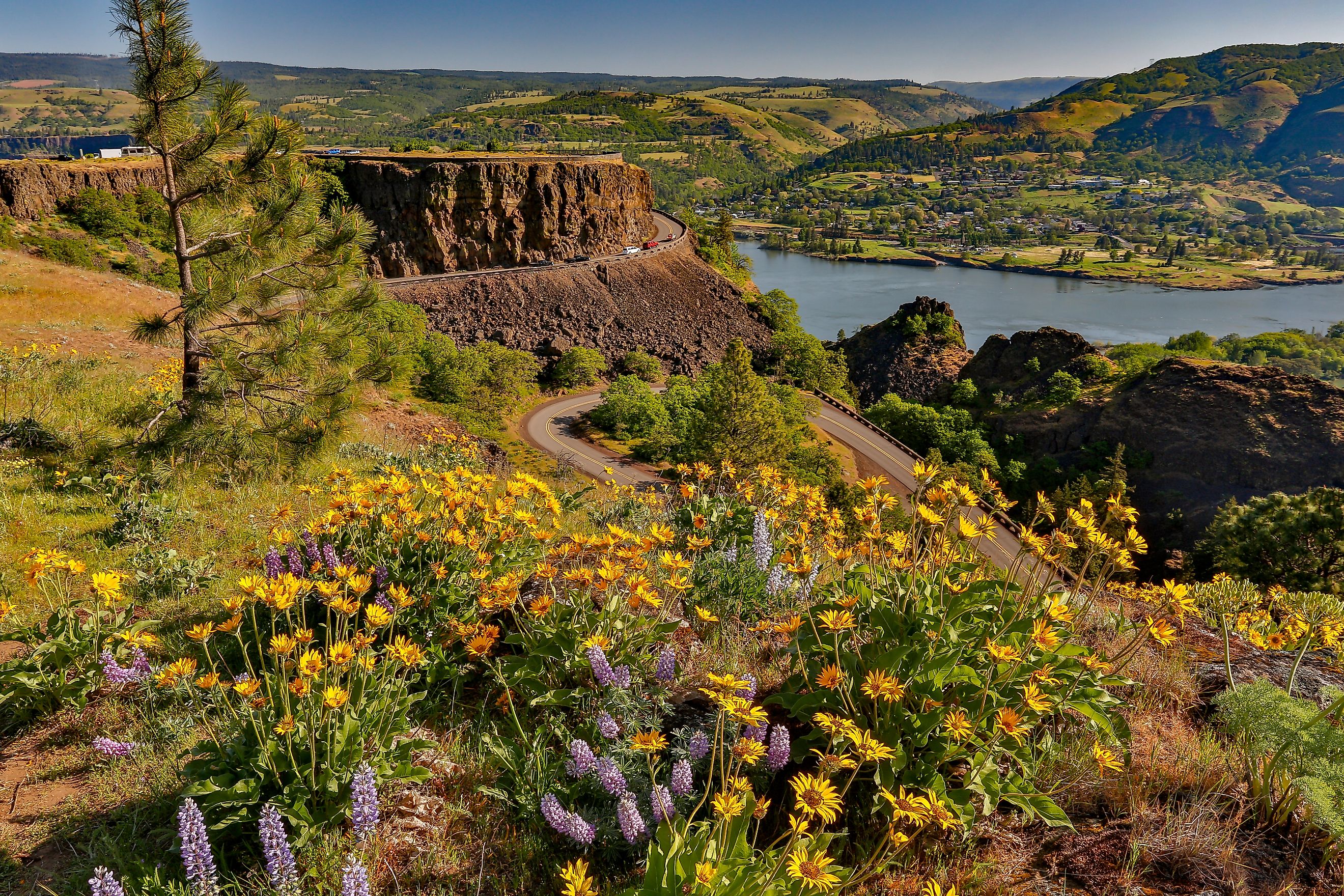
The Rowena Loops section of the old Columbia Gorge Scenic Highway, Oregon.
Once past Mosier, the countryside changes fast. Fir forests give way to ponderosa pine and oak savanna as you cross from the “wet” side of the Cascade Range to the “dry” side. Look out for Memaloose Island, a traditional burial place of the Columbia Basin peoples that was partly flooded after Bonneville Dam raised the water level.
Seven miles on, Rowena Crest Viewpoint is every bit as good a panorama as Crown Point, with Mount Hood and Mount Adams both in view and the Klickitat River bridge visible across the water in Washington. Visit in spring for views enhanced by balsamroot and lupine cover. The descent from here is known as the Rowena Loops, a series of switchbacks that is often used in car commercials. It is one of the most photographed roads in the state.
The byway finishes in The Dalles, a gathering place for Native peoples for over 11,000 years. It was also a staging point for the Oregon Trail, where settlers faced the last and worst leg of their journey. On the way in, the Columbia Gorge Discovery Center & Museum serves as the Columbia River Gorge National Scenic Area’s official interpretive center.
Finish this epic Oregon drive at Rock Fort, the basalt ledge where Lewis and Clark also camped in 1805, and again on the way home in 1806.
Driving the King of Roads

The Historic Columbia River Highway deserves more than a quick drive between Troutdale and The Dalles. Waterfalls, stone bridges, river overlooks, and early highway engineering give the route a clear story from beginning to end. Taking a full day allows time to see how the landscape changes across the gorge and why this road became known as the King of Roads.