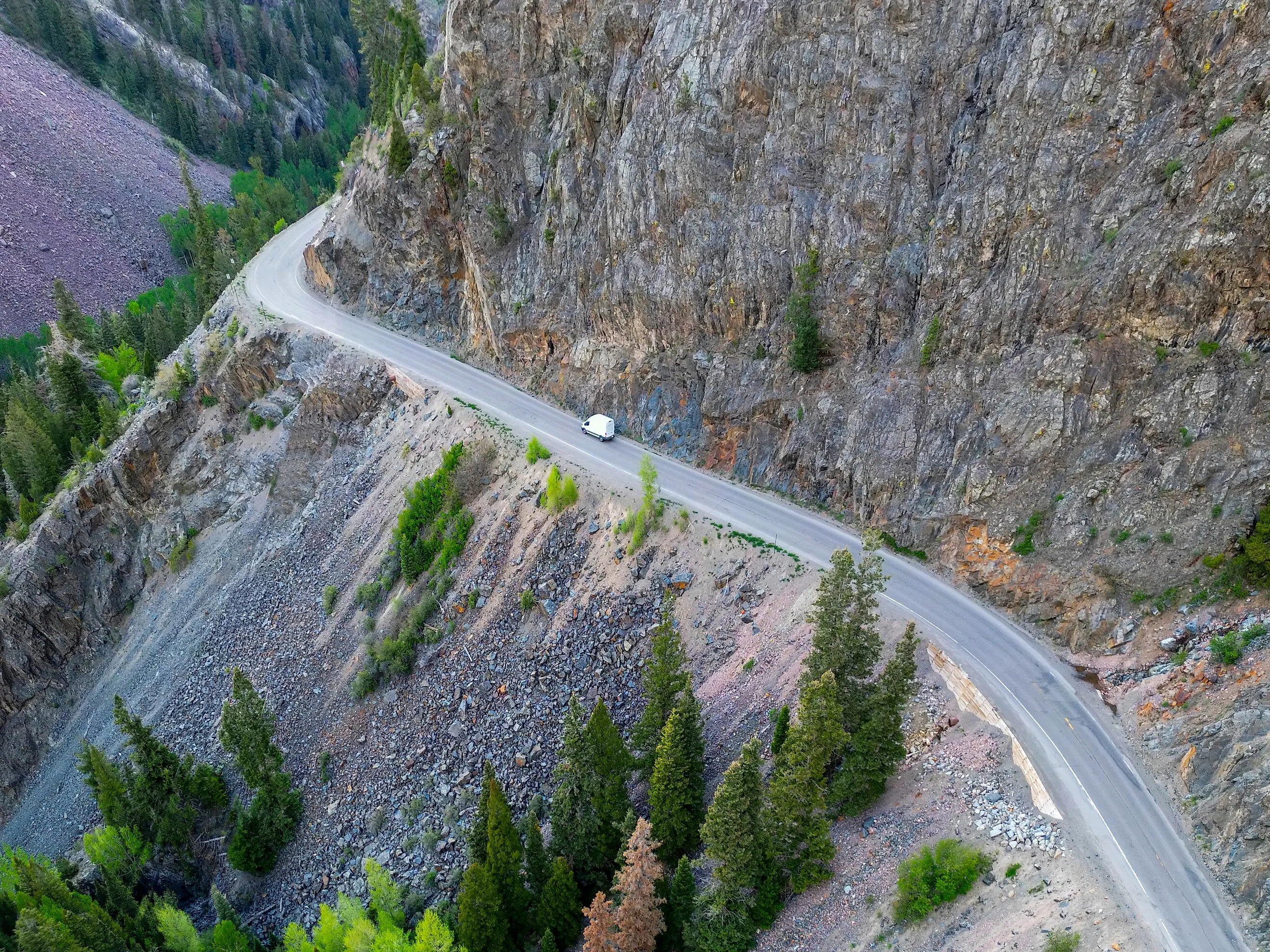
The Most Dangerous Mountain Pass Road In America
It is the Million Dollar Highway, the stretch of US 550 running roughly 25 miles between Ouray and Silverton in southwest Colorado, and the case for it does not rest on crash statistics. It rests on a single figure from the Colorado Department of Transportation: per mile, Red Mountain Pass carries the highest avalanche hazard of any road on the North American continent. The highway crosses around 70 avalanche chutes, has no guardrails along much of its length, narrows to 23 feet in places, and summits at 11,018 feet before dropping 3,000 feet into Ouray. It is also open year round, because the town at the other end has no other way out.
Here is what actually makes it dangerous, and why the fatality figures circulating online do not survive contact with the data.
The Avalanche Number Is The Real One

Most dangerous-road lists rank on crashes, and on that basis this highway would not lead anything. What sets it apart is snow. A CDOT spokeswoman has stated flatly that Red Mountain Pass has the highest avalanche hazard per mile on the continent, and the road intersects roughly 70 avalanche chutes across a very short distance.
The area takes around 300 inches of snow a year, and the terrain above the road is steep enough to deliver all of it downhill in a hurry. Keeping the route open requires a permanent apparatus of forecasting, control work and physical structures, plus a plow crew that drives into the hazard on purpose.
Why There Are No Guardrails

The missing guardrails are the detail everyone mentions, and the reason for them is practical rather than negligent. With 300 inches of snow to move every winter, the plows need somewhere to push it, and on a road cut into a cliff the only available direction is over the edge. A guardrail would turn each pass into a wall of accumulating snow with nowhere to go. In other sections the road is simply too narrow to install one without losing width the traffic needs.
So drivers get hairpin turns on the outside lane with unprotected drops of several hundred feet, which is the image the highway is famous for and the one that makes it feel far more lethal than the numbers support.
The Numbers Online Are Wrong

This is worth stating plainly because the misinformation is everywhere. You will find claims that the Million Dollar Highway has killed over 400 people since 1992, and others putting it at seven fatalities a year. Neither survives contact with the actual data.
When Colorado State Patrol figures were reported after a 2025 crash, the record showed 53 crashes on the relevant stretch, of which 33 involved vehicles leaving the roadway. Of all 53, exactly one resulted in a fatality, with 11 people injured.
That is a road where leaving the pavement is common and dying is not. The reputation has outrun the body count, largely because when something does go wrong here it goes wrong spectacularly, several hundred feet down a mountainside.
What Actually Kills People

The deaths that define this road are avalanche fatalities rather than driving accidents, and one chute accounts for most of them. On March 3, 1963, the slide caught Reverend Marvin Hudson and his two daughters, aged 11 and 17, as he drove to his pastorate in Silverton. Three crosses still stand beside the highway, and a marker records that the family were swept to their deaths a thousand feet north of the spot.
Two snowplow operators died in the same chute. Robert F. Miller, 36, was killed on March 2, 1970, an event that moved the then-mayor of Ouray to write a song about it called "Riverside Slide". Terry L. Kishbaugh, 28, died there on February 10, 1978. In total the East Riverside Slide killed five people from 1963 onward, all of them before a protective snowshed was finally built over that section.
It Was Never Designed For Cars

The alignment that makes the road frightening is a nineteenth-century one, laid out for an entirely different kind of traffic. Otto Mears, the railroad and toll-road builder known as the Pathfinder of the San Juans, partially funded and built the original route between 1880 and 1883 as a stagecoach and wagon road, to move ore out of the mines around Red Mountain, Silverton and Ouray. Horses and mules drew the first traffic over it.
The first automobile is reported to have made the trip around 1910 or 1911, a doctor in a Model T on a house call. The road was not fully paved until 1935. Everything since has been improvement to a line chosen by men working out where a mule could get through.
Where The Name Came From

Nobody is certain where the name came from, and three competing explanations remain in circulation. One holds that a road worker in 1921 estimated it would cost a million dollars to pave. Another attributes it to the million-dollar views. The third, and the most quoted locally, is that a traveler said they would not drive it again for a million dollars.
There is also a persistent story that the roadbed fill contains gold ore valuable enough to justify the name, which is the sort of thing that is repeated far more often than it is verified.
What Driving It Is Actually Like

The speed limit is 25 miles an hour and the 25-mile run takes at least 45 minutes in good conditions, which tells you most of what you need to know about the geometry of the thing.
Grades reach 8 percent. The curves are tight enough that some sections can only be taken at around 10 miles an hour. There are tunnels, rockfall zones, and long stretches where the outside lane has a cliff on one side and nothing on the other. Wildlife on the road is routine, with bears, elk, deer and mountain goats all present.
In good summer weather, driven at the posted speed by someone paying attention, it is a spectacular and entirely manageable drive. That qualifier is doing all the work.
The Road That Cannot Close

Most dangerous mountain roads in America shut for the winter. The Beartooth Highway closes for months. Trail Ridge Road closes. Going-to-the-Sun closes. This one does not, and the reason is Silverton.
The town depends on US 550 as its lifeline, so CDOT keeps the pass open through as much of winter as it possibly can. That decision is why snowplow operators have died here, and why the avalanche forecasting program on this stretch became as sophisticated as it is.
A road with the highest avalanche hazard per mile on the continent would be closed all winter almost anywhere else. It stays open because closing it would isolate a town.
The Ones That Rival It

A few other American roads make a genuine claim on the title and it is worth naming them. Black Bear Pass, above Telluride, is more dangerous per mile than anything on US 550, with a notorious one-way shelf and a series of tight switchbacks that have killed drivers. It is an unpaved four-wheel-drive route rather than a highway, which is why it is not the answer here.
The Beartooth Highway is longer and higher and closed most of the year. Going-to-the-Sun Road is narrower in places but far better protected. Colorado's own Independence Pass and the Alpine Loop passes are arguably worse but carry a fraction of the traffic.
The Million Dollar Highway wins because it combines genuine hazard with genuine volume: commuters, freight and tourists all use it daily, year round.
The Honest Verdict

The Million Dollar Highway is the most dangerous mountain pass road in America on the measure that matters, which is exposure to hazard rather than accumulated fatalities. Seventy avalanche chutes, the highest avalanche hazard per mile on the continent, no guardrails, 23-foot widths and an 11,018-foot summit, kept open all winter for a town that needs it.
What it is not is a road that kills large numbers of drivers, whatever the internet says. The crashes are frequent, the deaths are rare, and the genuine tragedies here have mostly involved people who were caught by snow rather than by the corner.