The Longest Bridges In North America
Louisiana holds eight of the ten longest bridges in North America. The reason is geography: roughly 40 percent of the contiguous coastal wetlands in the lower 48 states sit inside Louisiana, and any highway that wants to cross south Louisiana ends up running on stilts for miles at a time. The list below ranks the longest road bridges on the continent by total length, with one entry each from Canada and California breaking the Louisiana streak, plus an honorable mention for Mexico's longest at the end.
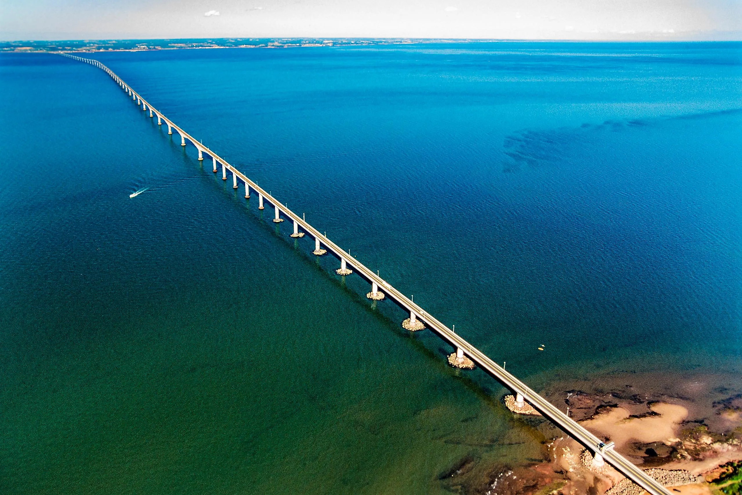
1. Lake Pontchartrain Causeway, Louisiana - 23.83 miles

The Causeway runs between Metairie in Jefferson Parish and Mandeville in St. Tammany Parish, two parallel two-lane spans carrying traffic across the middle of Lake Pontchartrain. The southbound bridge opened on August 30, 1956 and the northbound bridge opened on May 10, 1969. Together they rest on roughly 9,500 hollow concrete piles, a design Maxwell Upson's Raymond Concrete Pile Company developed specifically for this project after no existing pile could match the required strength.
The Causeway held the Guinness World Record as the longest bridge over water until 2011, when China's Qingdao Jiaozhou Bay Bridge opened. Guinness then split the category in two: the Jiaozhou Bay Bridge took "longest bridge over water (aggregate length)," while the Causeway retained "longest continuous bridge over water," the distinction it still holds today. Motorists lose sight of land for about eight miles in the middle of the crossing. The American Society of Civil Engineers designated the Causeway a National Historic Civil Engineering Landmark in 2013.
2. Manchac Swamp Bridge, Louisiana - 22.8 miles

The Manchac Swamp Bridge is a twin concrete trestle structure carrying Interstate 55 and US Route 51 for 22.8 miles across the cypress swamp north of Lake Pontchartrain. Built in 1979 at a cost of about $7 million per mile, it is one of the longest toll-free bridges in the world and one of the longest interstate-highway bridges anywhere. The crossing makes up roughly one third of the entire length of I-55. Local folklore associated with the swamp (and an unsolved 1915 train wreck that killed several dozen people nearby) has given the bridge a reputation as haunted; there is no engineering evidence for the ghosts, but the legend has its own tourism economy.
3. Louisiana Airborne Memorial Bridge (Atchafalaya Basin Bridge), Louisiana - 18.2 miles

Louisiana takes all three spots on the podium. The Atchafalaya Basin Bridge, officially renamed the Louisiana Airborne Memorial Bridge in honor of the 82nd Airborne Division, is a 18.2-mile (29.3 km) suspended segment of Interstate 10 connecting Baton Rouge and Lafayette. Construction ran from 1971 to 1973. The bridge crosses the Atchafalaya Basin, the largest river swamp in the United States at roughly 1.4 million acres, and is unusual in that it carries parallel bridges for most of its length before merging into a single structure at the Whiskey Bay Pilot Channel crossing of the Atchafalaya River.
4. Chesapeake Bay Bridge-Tunnel, Virginia - 17.6 miles

Officially the Lucius J. Kellam Jr. Bridge-Tunnel, the CBBT is a 17.6-mile complex of trestle bridges, tunnels, and manmade islands connecting Virginia Beach with Virginia's Eastern Shore across the mouth of the Chesapeake Bay. It opened on April 15, 1964, replacing the earlier ferry service. Two one-mile tunnels (Thimble Shoal and Chesapeake Channel) duck beneath the bay's main shipping lanes so freighters can pass overhead. A 1999 parallel-trestle expansion doubled the above-water capacity to four lanes. A second Thimble Shoal Tunnel has been under construction since 2017; the tunnel boring machine "Chessie" broke through to the receiving pit on January 27, 2025 after striking a turn-of-the-century English ship's anchor that delayed mining by eight months. The full project is scheduled for completion in early 2028.
5. Bonnet Carré Spillway Bridge, Louisiana - 11 miles

The Bonnet Carré Spillway Bridge carries Interstate 10 for 11 miles over the spillway, Lake Pontchartrain, and the LaBranche Wetlands. The bridge opened in 1972 and runs across one of the largest flood-control structures in the country. The spillway itself was built between 1929 and 1931 in the aftermath of the catastrophic 1927 Mississippi River flood, and it diverts high water into Lake Pontchartrain to protect New Orleans whenever the river rises high enough to threaten the city's levees. The structure has been opened 15 times as of late 2024, including several openings in the 2010s and 2020s that fueled freshwater intrusions into Mississippi Sound and killed dolphins and oysters downstream.
6. Louisiana Highway 1 Bridge, Louisiana - 8.3 miles
The Louisiana Highway 1 Bridge, also known as the Gateway to the Gulf Expressway, is an 8.3-mile concrete trestle toll bridge that carries Highway 1 across Bayou Lafourche and surrounding marshland in Lafourche Parish. The bridge opened in 2009 at a cost of about $370 million and connects Leeville with Port Fourchon, the service hub for roughly 90 percent of Gulf of Mexico deepwater oil and gas activity. The bridge was specifically built to elevate the only road to Port Fourchon above the rapidly subsiding marsh; LA-1 below the bridge has been disappearing at roughly 30 feet per year of shoreline loss in some segments.
7. Confederation Bridge, Canada - 8 miles

The Confederation Bridge (Pont de la Confédération in French) opened on May 31, 1997 after four years of construction by a Canadian-Dutch joint venture. It carries the Trans-Canada Highway 12.9 km (8 miles) across the Abegweit Passage of the Northumberland Strait, linking Borden-Carleton on Prince Edward Island with Cape Jourimain on the New Brunswick mainland. The bridge is the longest in the world over ice-covered water. Its 44 main piers are spaced 250 meters apart (a record for prestressed concrete construction at the time) and each pier carries a conical ice shield designed to break sea ice into smaller pieces rather than fight it. The bridge is designed for a 100-year service life and cost about C$1.3 billion to build.
8. Jubilee Parkway, Alabama - 7.99 miles

The Jubilee Parkway is a pair of two-lane viaducts that carries Interstate 10 across the north end of Mobile Bay between Mobile and Spanish Fort. It opened in 1978 and runs roughly parallel to the older Battleship Parkway, which is now US 90 / US 98. The bridge is named for the rare "jubilees" that occur in Mobile Bay each summer, in which low oxygen levels in deep water push large numbers of crabs, shrimp, and flounder into the shallows where they can be gathered by hand. Alabama transportation planners have debated rerouting and expanding the parkway for more than two decades to relieve congestion at the George Wallace Tunnel on the western approach.
9. San Mateo-Hayward Bridge, California - 7 miles

The San Mateo-Hayward Bridge crosses 7 miles (11.27 km) of San Francisco Bay between Foster City in San Mateo County and Hayward in Alameda County, carrying State Route 92. The original two-lane bridge opened in 1929. The current six-lane structure replaced it in 1967 at a cost of $70 million; a widening project in 2002 added the third lane in each direction over the trestle portion. The bridge's most distinctive feature is the high-rise orthotropic-steel span at the western end, which rises to 135 feet above the shipping channel and uses a single 750-foot main span. The eastern 5.9 miles is a low-level concrete trestle just 15 feet above the water at high tide.
10. Seven Mile Bridge, Florida - 6.79 miles

The Seven Mile Bridge connects Knight's Key (part of Marathon) in the Middle Keys with Little Duck Key in the Lower Keys, carrying US Route 1. The modern bridge was built between 1978 and 1982 and is technically 6.79 miles long; the name rounds up. Henry Flagler's original bridge, built between 1909 and 1912 as part of his Florida East Coast Railway extension to Key West, still runs alongside it. The Labor Day Hurricane of 1935 destroyed Flagler's railroad, and the right-of-way was converted to a road in 1938. The Old Seven Mile Bridge was closed to vehicles when the new bridge opened, and a 2.2-mile section to Pigeon Key was reopened on January 12, 2022 as a pedestrian and cycling path after a $44 million restoration. The bridge has appeared in films including True Lies, Licence to Kill, and 2 Fast 2 Furious.
Honorable Mention: Zacatal Bridge, Mexico - 2.4 miles

The Zacatal Bridge (Puente El Zacatal) is the longest road bridge in Mexico at 3,861 meters (2.4 miles). It opened in October 1994 and carries Federal Highway 180 across Laguna de Términos between the Atasta Peninsula on the mainland and Isla del Carmen, the island that holds Ciudad del Carmen. The bridge is the main road link into the Yucatán Peninsula along the Gulf Coast route and serves as the primary land artery for the offshore oil industry around Ciudad del Carmen.
Why Louisiana
The six Louisiana entries on this list are not a coincidence. Louisiana lost roughly 2,000 square miles of coastal wetlands between 1932 and 2016, a rate of loss equivalent to a football field every 100 minutes. The state's road network has had to compensate by building elevated highways over increasingly waterlogged ground. Interstate 10, Interstate 55, and Louisiana Highway 1 all run for long stretches on concrete trestles for the same reason: there is no longer enough firm land between Baton Rouge and the Gulf to support a conventional roadbed. The Lake Pontchartrain Causeway, built in 1956, was the first project in the country to make this kind of trestle construction economically viable at scale, and the same engineering template is what made every Louisiana bridge after it possible.
The 25 Longest, Ranked
| Rank | Bridge | Country | Miles | Kilometers |
|---|---|---|---|---|
| 1 | Lake Pontchartrain Causeway | United States | 23.83 | 38.35 |
| 2 | Manchac Swamp Bridge | United States | 22.8 | 36.7 |
| 3 | Louisiana Airborne Memorial Bridge | United States | 18.2 | 29.3 |
| 4 | Chesapeake Bay Bridge-Tunnel | United States | 17.6 | 28.3 |
| 5 | Bonnet Carré Spillway Bridge | United States | 11 | 17.7 |
| 6 | Louisiana Highway 1 Bridge | United States | 8.3 | 13.3 |
| 7 | Confederation Bridge | Canada | 8 | 12.9 |
| 8 | Jubilee Parkway | United States | 7.99 | 12.87 |
| 9 | San Mateo-Hayward Bridge | United States | 7 | 11.27 |
| 10 | Seven Mile Bridge | United States | 6.79 | 10.93 |
| 11 | General W.K. Wilson Jr. Bridge | United States | 6.1 | 9.8 |
| 12 | Norfolk Southern Lake Pontchartrain Bridge | United States | 5.8 | 9.3 |
| 13 | Chacahoula Swamp Bridge | United States | 5.6 | 9.0 |
| 14 | Frank Davis Memorial Bridge | United States | 5.5 | 8.85 |
| 14 | Richmond-San Rafael Bridge | United States | 5.5 | 8.85 |
| 16 | Virginia Dare Memorial Bridge | United States | 5.2 | 8.4 |
| 17 | Mackinac Bridge | United States | 5 | 8.0 |
| 18 | LaBranche Wetlands Bridge | United States | 4.9 | 7.9 |
| 19 | Maestri Bridge | United States | 4.8 | 7.7 |
| 20 | James River Bridge | United States | 4.4 | 7.1 |
| 21 | Huey P. Long Bridge | United States | 4.3 | 7.0 |
| 22 | Frederick G. Gardiner Expressway | Canada | 4.2 | 6.8 |
| 23 | Sunshine Skyway Bridge | United States | 4.1 | 6.6 |
| 24 | St. George Island Bridge | United States | 4.09 | 6.59 |
| 25 | Astoria-Megler Bridge | United States | 4 | 6.5 |