8 Most Scenic Drives in Queensland
Queensland, Australia, stretches from the subtropical hinterland behind the Gold Coast to the tropical rainforests of the far north and the red-earth outback beyond. The state offers a driving landscape as varied as any on the continent. And with the eight most scenic drives in Queensland, travelers get a bit of everything.
The Great Barrier Reef Drive traces the coastline between two World Heritage areas from Cairns to Cape Tribulation. Inland, the Gillies Range Road climbs thousands of feet, slithering its way over hundreds of curves to reach the volcanic highlands of the Atherton Tablelands. In the southeast, the Blackall Range Tourist Drive rises above the Sunshine Coast into a cool ridge of art villages and valley lookouts. And on the far side of the state, the Overlander's Way crosses miles of outback from Townsville to Mount Isa.
Great Barrier Reef Drive (Cairns to Cape Tribulation)

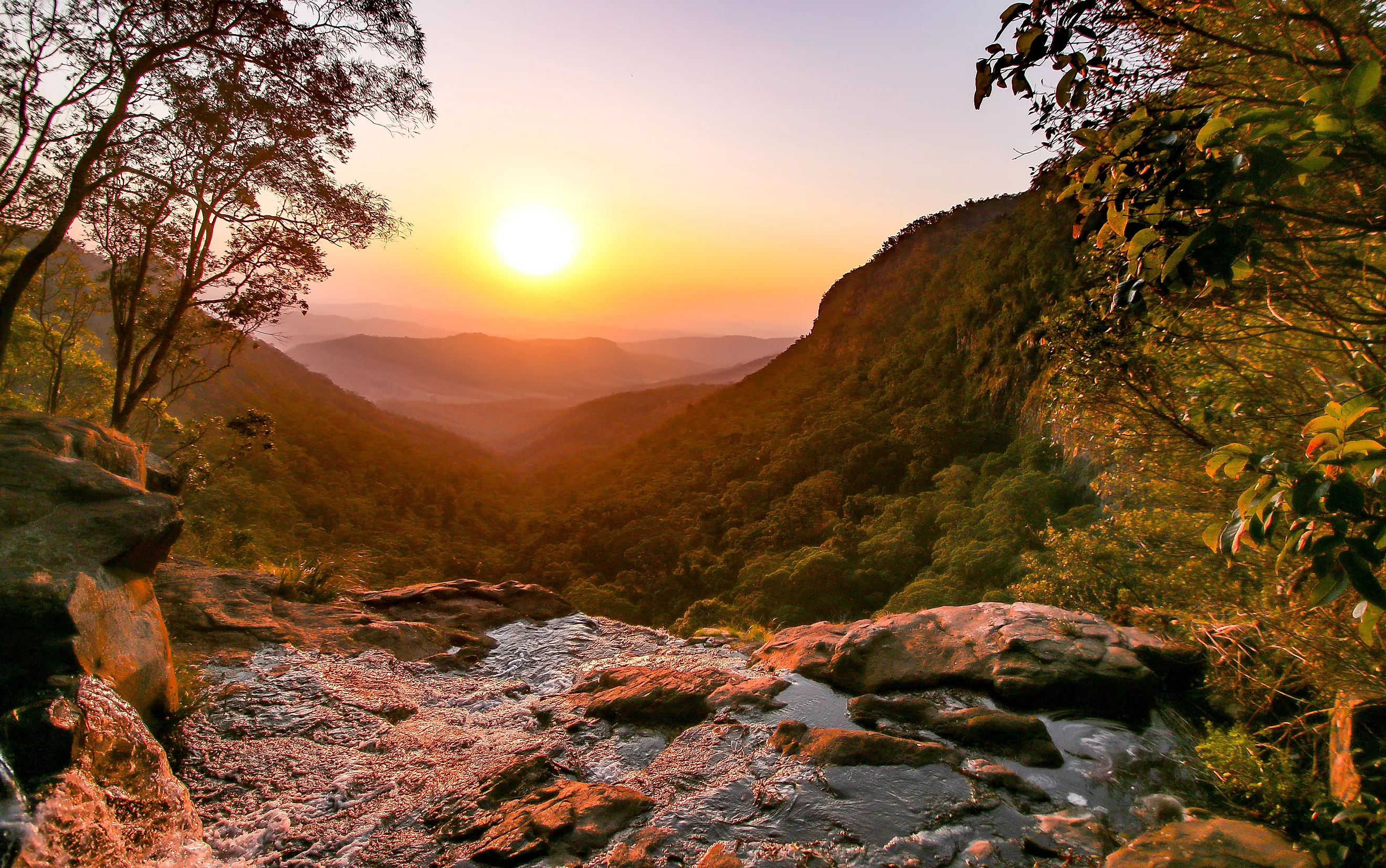
The Great Barrier Reef Drive follows the Captain Cook Highway and Cape Tribulation Road for approximately 87 miles (140 kilometers) from Cairns to Cape Tribulation, passing between two World Heritage-listed sites for nearly the entire distance. The Wet Tropics rainforest rises on one side while the Coral Sea and the Great Barrier Reef stretch to the horizon on the other. The drive takes about 2.5 hours without stops, but the beaches, lookouts, and detours reward a full day or more.
Leaving Cairns, the Captain Cook Highway hugs the coast through a chain of beach communities before climbing to Rex Lookout. The road descends into Port Douglas, a resort town on a narrow peninsula between Four Mile Beach and Dickson Inlet. North of Mossman, the landscape shifts as the road narrows and the rainforest canopy closes in. The Daintree River ferry, a cable-guided barge operating from early morning until midnight, marks the transition into the Daintree Rainforest proper.
North of the river, Cape Tribulation Road winds through dense canopy past Alexandra Lookout before ending where the paved road stops at Cape Tribulation, where one of the oldest tropical rainforests on Earth meets the largest coral reef system in the world.
The entire route is paved and accessible by two-wheel-drive vehicles. Mobile coverage drops out north of the Daintree River. The dry season from May to October offers the most comfortable conditions and the lowest risk of road closures from tropical rain.
Gillies Range Road and the Waterfall Circuit (Gordonvale to Millaa Millaa)

The Gillies Range Road begins at Gordonvale and spirals upward through more than 260 curves, gaining roughly 2,625 feet (800 meters) in elevation over a winding ascent that takes about 45 minutes. The temperature drops noticeably as the road climbs, and the coastal heat gives way to the cooler highland plateau above.
At the top of the range, the landscape opens into a patchwork of dairy farms, volcanic crater lakes, and remnant rainforest that feels remarkably different from the coast just 19 miles (30 kilometers) east. Lake Barrine and Lake Eacham, both crater lakes within the Crater Lakes National Park, sit close to the road and offer swimming, walking trails, and roadside pull-offs with views across still water ringed by dense forest.
The village of Yungaburra, a heritage-listed township of timber buildings and a famous platypus-viewing area along Peterson Creek, provides a natural midpoint. South of Malanda, the route leads to the Millaa Millaa Waterfall Circuit, an 11-mile (17-kilometer) paved loop on Theresa Creek Road that passes three waterfalls in quick succession. Millaa Millaa Falls, widely cited as one of the most photographed waterfalls in Australia, drops into a deep swimming hole, and Zillie Falls and Ellinjaa Falls follow within a few miles.
The full drive from Gordonvale to the waterfall circuit and back covers roughly 130 miles (210 kilometers) and suits any vehicle, though the range road's tight curves require attention in wet conditions or fog. The dry season from April to October offers the clearest weather.
Great Green Way (Cairns to Townsville)

The Great Green Way follows the Bruce Highway (Highway 1) for approximately 217 miles (350 kilometers) between Cairns and Townsville, passing through the southern stretch of the Wet Tropics World Heritage Area. The drive takes about 4.5 hours without stops, but the waterfalls, sugar towns, and side detours deserve at least two days.
Heading south from Cairns, the distinctive silhouette of Walsh's Pyramid — a steep, free-standing mountain visible from the highway — marks the transition from suburban Cairns into cane-farming country. The road threads through Innisfail, an art-deco town built on the sugar industry, before reaching Tully, which celebrates its status as one of the wettest towns in Australia with a giant golden gumboot standing 26 feet (7.9 meters) tall.
East of the highway, a short detour reaches Mission Beach, where endangered southern cassowaries are known to cross between rainforest and shoreline. Further south, a 32-mile (52-kilometer) inland detour from Ingham leads to Wallaman Falls in Girringun National Park, the highest single-drop waterfall in Australia at 879 feet (268 meters).
The highway continues through Cardwell, where views open across the Hinchinbrook Channel to Hinchinbrook Island. The road is paved throughout, and the dry season offers the most pleasant conditions, though the wet season brings the waterfalls to their most dramatic flow.
Blackall Range Tourist Drive (Landsborough to Mapleton)

The Blackall Range Tourist Drive (Tourist Drive 23) winds approximately 34 miles (55 kilometers) along a subtropical ridge above the Sunshine Coast, passing through a chain of art-filled villages at roughly 1,640 feet (500 meters) above sea level. The drive can be completed in about an hour, but the lookouts, galleries, and produce stalls along the way make a half day or more the better pace.
From Landsborough, reached via Steve Irwin Way from the Bruce Highway, the road climbs through dairy country and subtropical forest to Maleny, where the main street supports bookshops, cafes, and artisan food producers. The road continues north along the range through Montville, a village of art galleries and heritage timber buildings that draws weekend visitors from across southeast Queensland.
Between the towns, roadside lookouts offer sweeping views east over the coastal plain to the Sunshine Coast beaches and, on clear days, the offshore islands. The drive ends at Mapleton, where Mapleton Falls National Park provides a short walk to a waterfall lookout over the Obi Obi Valley.
The road is paved throughout. Weekend traffic can build around Montville and Maleny, so a midweek visit ensures a quieter drive. Fog can settle on the range during winter mornings, requiring slower speeds.
Gold Coast Hinterland (Nerang to Lamington National Park)

The drive from Nerang into Lamington National Park follows a 22-mile (36-kilometer) mountain road from Canungra to the Green Mountains section of the park, climbing from the valley floor into one of the largest preserved subtropical rainforests in Australia. Lamington forms part of the Gondwana Rainforests of Australia World Heritage Area, and the drive itself serves as the transition from suburban Gold Coast to ancient volcanic landscape in under 90 minutes.
From Nerang, the road heads west through rolling farmland to Canungra, a small service town at the base of the McPherson Range. Beyond Canungra, the Lamington National Park Road begins its ascent, narrowing into a winding corridor of hairpin bends that threads through increasingly dense forest. Occasional breaks in the canopy reveal views across the Numinbah Valley hundreds of feet below.
At the top, the Green Mountains day-use area provides access to walking tracks and the Tree Top Walk at O'Reilly's Rainforest Retreat, a 591-foot (180-meter) suspension bridge system set 49 feet (15 meters) above the forest floor. An alternative route reaches the Binna Burra section via Beechmont, offering a different perspective over the escarpment.
Both roads are paved but narrow, with tight curves that demand careful driving, and neither is suitable for caravans. Winter offers the clearest skies, while the warmer months bring heavier rain and occasional closures.
Scenic Rim (Brisbane to the McPherson Range and Back)

The Scenic Rim loop covers roughly 195 miles (314 kilometers) through the volcanic landscape southwest of Brisbane, passing through open farming country, remnant rainforest, and mountain ridgelines that form the border between Queensland and New South Wales. The drive takes about 4.5 hours without stops, but the variety of scenery along the way supports a full day at a comfortable pace.
From Brisbane, the route heads south through Beaudesert and onto the Mount Lindesay Highway toward Rathdowney, where Captain Logan Lookout provides elevated views across the surrounding ranges. The highway climbs to the ridgeline of the McPherson Range before crossing into New South Wales and connecting to the Summerland Way. A left turn onto Lions Road winds through the Border Ranges National Park, with lookouts reaching as far as the coast and Wollumbin (Mount Warning), before reconnecting with the Mount Lindesay Highway for the return north.
The landscape shifts from flood-plain farmland along the Logan River to eucalyptus-covered ranges and pockets of subtropical rainforest. The route is paved throughout, though Lions Road is narrow and single-lane in sections, and landslips can close it after heavy rain — checking conditions before departure is advisable. Traffic remains light outside the Brisbane commuter zone. Spring brings wildflowers, and autumn delivers warm days with cooler evenings on the elevated sections.
Overlander's Way (Townsville to Mount Isa)

The Overlander's Way follows the Flinders Highway for approximately 559 miles (900 kilometers) from Townsville on the coast to Mount Isa in the northwest outback, tracing the old droving routes that once carried cattle herds across the continent. The drive takes about 9.5 hours without stops, but the heritage towns and geological landmarks along the way demand at least several days.
Leaving Townsville, the highway heads west through dry savannah to Charters Towers, a gold-rush town roughly 81 miles (130 kilometers) inland that was the second-largest city in Queensland during the 1890s. Heritage buildings from the 1880s line the main streets, and the Ghosts of Gold Heritage Trail maps the town's mining history. West of Charters Towers, the landscape flattens into open grassland as the road passes White Mountains National Park.
Hughenden, roughly halfway along the route, sits on what was once the shoreline of an ancient inland sea. Julia Creek and Cloncurry mark former droving stops further west, and the terrain grows increasingly arid as the road approaches Mount Isa. The highway is paved throughout, though fuel stops grow further apart west of Charters Towers.
The drive is best undertaken between April and October, when temperatures are manageable and flooding risk is lowest. Traffic remains light for the entire distance.
Savannah Way (Cairns to Normanton — Queensland Section)

The Queensland section of the Savannah Way covers roughly 435 miles (700 kilometers) from Cairns to the Gulf of Carpentaria town of Normanton, crossing the Atherton Tablelands and the dry savannah woodlands of the Gulf Country. The full drive takes about 8.5 hours without stops, but three to four days allows time for the geological sites and detours that make the route exceptional.
From Cairns, the Kennedy Highway climbs onto the Atherton Tablelands, passing through the township of Atherton before the landscape transitions from rainforest to open savannah woodland. At Undara Volcanic National Park, a detour leads to one of the longest lava tube systems in the world, formed by eruptions roughly 190,000 years ago.
West of the park, the road passes through Georgetown before reaching Croydon, where the heritage Gulflander railway operates between Croydon and Normanton. Normanton itself sits on the Norman River near the Gulf of Carpentaria. The route is mostly paved, though some sections west of Georgetown may be gravel. A high-clearance vehicle improves comfort on these stretches. The road is only reliably accessible during the dry season from May to October, as wet-season flooding regularly closes sections. Fuel stops grow sparse west of the tablelands.
Queensland's Open Roads
These eight drives demonstrate the breadth of terrain packed into a single Australian state — from the reef-meets-rainforest coastline north of Cairns to the red-earth outback west of Townsville and from the cool volcanic highlands of the Atherton Tablelands to the subtropical ridges behind the Gold Coast. Keep the driving experience safe and enjoyable by checking road conditions with the Queensland Department of Transport and Main Roads, carrying extra water in remote areas, and allowing for the possibility of seasonal closures during the rainy season.