7 Most Scenic Drives in Pacific Coast
The Pacific Coast holds some of the most remarkable drives in all of North America. In fact, there are several highways that trace the edge of the continent, passing by lofty seaside cliffs, towering forests, and vast ocean views. From California’s rugged Big Sur coastline to Washington’s quiet woodland roads, each route uncovers a distinct section of the Pacific’s wonderful geography and character.
The specific drives we will be discussing today link small towns, state parks, and other natural and historic landmarks, while generally providing uninterrupted access to the coast’s changing terrain from the southern border of Canada to the northern reach of Mexico.
Pacific Coast Highway - California

A lengthy route, more than 650 miles along California’s seaboard, the Pacific Coast Highway is among the most famous coastal drives in the United States. Although this named highway technically extends 1,650 miles (from Seattle to San Diego), the Californian portion is widely considered the most popular and well-known singular stretch.
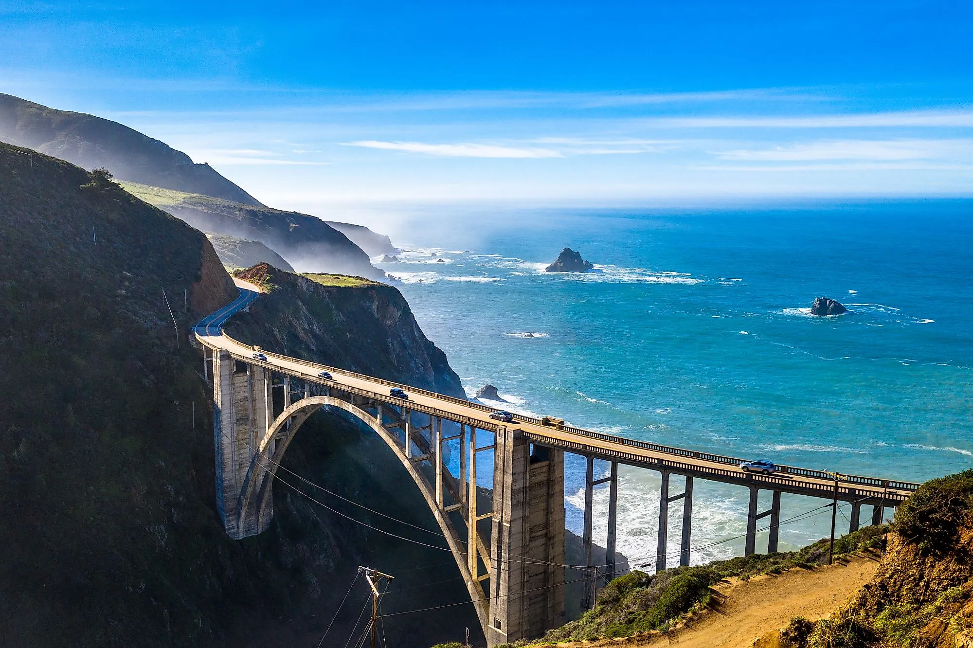
Typically, State Route 1 runs from Dana Point in Orange County to Leggett in Mendocino County, following the oceanside through a changing landscape of cliffs, beaches, and headlands. The route passes through major highlights such as Big Sur (a top-tier driving route on its own), Monterey, San Luis Obispo, and Malibu, each section revealing a different aspect of the Golden State's incredibly photogenic shoreline.
Activities along the way are highly varied, as you can stop at Bixby Creek Bridge for wide-reaching ocean vistas, explore Hearst Castle near San Simeon, or watch elephant seals at Piedras Blancas, just for a few recommendations. Then, north of San Francisco, the road narrows and winds through redwood forests before meeting rugged coves in and around Mendocino.
This drive requires patience, and preferably lots of time, with its tight turns and plethora of stops discouraging rushing. With careful planning, you'll be rewarded with continuous, unobstructed scenery that defines the Pacific coast’s natural and man-made landscapes like no other.
Pacific Coast Scenic Byway - Oregon

Similar to its Californian counterpart, this drive is an unbeatable way to explore the entirety of Oregon's coastline. The Oregon Coast Scenic Byway runs roughly 363 miles from the Columbia River in the north to the California border down south, tracing the Pacific shoreline past rolling seaside hills, beaches, dunes, and parklands. U.S. Highway 101 also passes through notable towns like Cannon Beach, Newport, and Coos Bay, each offering access to more coastal landmarks, state and national parks, and useful travel amenities.
Key stops include the iconic Haystack Rock, Devils Punch Bowl, and Cape Perpetua, where dense forests and idyllic viewpoints rise above the ocean. Bridges, promontories, and countless lighthouses along the route provide other elevated perspectives of the Pacific's powerful waves crashing against weather-beaten shores. The byway also crosses through numerous protected areas, such as the Oregon Dunes National Recreation Area, where vast sand landscapes meet the sea.
The road alternates between gentle curves and sharp turns, requiring attentive driving, but the payoff is constant visual variety and a fun time for motorcyclists, drop-top cars, or anyone else with a fast, agile vehicle. For many, however, the appeal mainly lies in the fact that the Oregon Coast Scenic Byway is less travelled than California’s Pacific Coast Highway, yet offers equally impressive coastal scenery.
Washington State’s Pacific Coast Scenic Byway

To cap off the list of the West's three state-spanning coastal driving routes, Washington has its own Pacific Coast scenic byway, which extends roughly 350 miles from the Columbia River near Ilwaco to the Olympic Peninsula’s northern border and back southeast to Olympia. For the most part, WA-101 follows the shoreline, but occasionally dips inland into the state's expansive forests.
This route cuts through Long Beach, Ocean Shores, and Westport, offering detours to get to a huge collection of coastal parks, historic lighthouses, harbors, and more. Must-see stops include Cape Disappointment State Park (near where Lewis and Clark concluded their continent-spanning journey in 1805), the rugged, windswept beaches around Olympic National Park, and the state capital building in Olympia. The drive alternates between open ocean views and, as mentioned, forested sections, often taking you near a huge diversity of flora and fauna, whether it be mammoth-sized trees or flocks of migrating sea birds. It is truly a bucket list drive for nature lovers of all kinds.
Washington's coast is relatively undeveloped (besides Seattle's metro area), so, again, compared with California, this byway sees fairly lighter traffic, providing a quieter experience that many savvy travellers prefer.
Trees to Sea Scenic Byway - Oregon

The Trees to Sea Scenic Byway links Oregon’s forested Coast Mountains with the ocean, running approximately 68 miles from the outskirts of Portland to the rural city of Tillamook. As you stray from Portland's busy metro, the air shifts from pine-laden to salty as the diverse landscapes along this route open up to tidal flats and fresh ocean breezes. It primarily follows the Wilson River Highway (Oregon Route 6), crossing through a series of state forests, river valleys, and mountain ridges before ultimately descending to the coast.
Here, you will move from fertile farmland and vineyards near the Willamette Valley into dense stands of Douglas firs and cedars within the Tillamook State Forest. Scenic pullouts along the Wilson River Trail provide access to an abundance of trails, waterfalls, and lookouts over verdant slopes. Must-see points of interest include the Tillamook Forest Center, Elk Creek Campground, and Munson Creek Falls State Natural Site, the latter being the tallest waterfall in the Coast Range.
The Trees to Sea Byway encompasses a fairly compact but striking cross-section of the Beaver State's interior forests and coastal terrain, all within a single day’s drive.
Sonoma County Route 116 - California

State Route 116 runs for about 23 miles across Sonoma County, linking the Pacific coast at Jenner with Sebastopol in the east. Officially recognized as a California Scenic Highway, valued for its mix of forest, river, and coastal terrain, the route is full of pullouts that allow you to stop at parks, notable stands of redwoods (like those at Armstrong Redwoods State Natural Reserve), and lots of countryside towns offering up world-class restaurants, inns, and other amenities to help you along the way.
The drive follows the Russian River inland, winding through multiple redwood groves and small communities like Duncan Mills, Monte Rio, and Guerneville. It is among the best routes not just for sightseers, but wine lovers as well, with countless wineries to be found nearby, like Lynmar Estate, Russian River Vineyards, Korbel Winery, and several others.
East of Forestville, the landscape notably shifts to the orchards and vineyards that exemplify the Sonoma area, showing off the county’s rich, longstanding agricultural ties. Whether you're looking for a bottle of local vintage or a basket of fresh fruit, you can find it along this drive.
Strait of Juan de Fuca Scenic Byway - Washington

The Strait of Juan de Fuca Highway, designated officially as State Route 112, follows Washington’s northwestern coast for about 61 miles between Port Angeles and Neah Bay. The byway traces the southern edge of the strait, offering continuous views across the water to Vancouver Island, and on the other side of the highway, the Olympic Mountains rising inland.
The road curves through a number of small coastal communities such as Clallam Bay, Sekiu, and Joyce, where fishing docks and tide flats define the shoreline and the economy (besides the dollars coming in from national park tourism). Should you want to make a detour to explore the area's rain-soaked forests, several turnouts and trailheads on the way lead into Olympic National Park and the Makah Reservation. It's actually one of the few drives in the region where both rugged coastline and old-growth forest remain largely undeveloped, making it perfect for hikers and campers in search of some solitude far removed from big city life.
Near Neah Bay, however, you can continue to Cape Flattery, the northwesternmost point in the contiguous United States, where a short boardwalk trail ends at a viewpoint over sea stacks spread nearby throughout the ocean.
Skyline Boulevard - California

Skyline Boulevard, officially California State Route 35, meanders along the spine of the Santa Cruz Mountains for about 40 miles between Bear Creek Redwoods Open Space Preserve near San Francisco and the Upper Crystal Springs Reservoir Vista Point. The route completely runs atop this mountain ridge that separates the coastline from Silicon Valley, giving you great views of both.
On the western side, you will come across redwood-covered slopes and glimpses of the ocean; to the east, the landscape opens to the valley and San Francisco Bay. The drive also passes near several protected areas, including Purisima Creek Redwoods Preserve, Windy Hill Open Space Preserve, and Castle Rock State Park, where numerous short trails and overlooks branch directly from the roadway.
Popular with cyclists and motorcyclists, clear days on Skyline Boulevard reveal yet more spectacular views stretching from the Farallon Islands to Mount Diablo, and it remains one of the most scenic ridge drives in Northern California by a good margin.
Explore the West Coast on the Road Today
Driving the Pacific Coast is less about reaching a destination and more about following the awe-inspiring geography that defines the western edge of the continent. Each route mentioned above, whether carved through forests, clinging to perilous cliffs, or tracing river valleys, displays a side of this magnificent shoreline that all avid travellers should experience at least once. Together, these byways can form a continuous journey linking three states, countless ecosystems, and a shared history of exploration, preservation, and nature-focused urban development.