11 Most Scenic Drives in Pennsylvania
Pennsylvania hides much of its scenery behind trees. On most back roads, the canopy closes in and stays that way, so the best drives are the ones that suddenly break into the open and hold the view. Near the Ohio line, a byway runs beside a 17,088-acre reservoir. In Clinton County, the road climbs high above 4,715 acres with no road running through them. By the time the route reaches Lancaster County, the scenery opens again across the Susquehanna, where a two-lane road crosses 21 spans beneath a rim rising 380 feet above the river. These 11 Pennsylvania drives earn their place on sightlines.
Crawford Lakelands Scenic Byway

Pymatuning Reservoir is the largest lake in Pennsylvania at 17,088 acres. The Crawford Lakelands Scenic Byway runs along its eastern shore and links it to Conneaut Lake using PA 285, PA 618, PA 18, and US 6. Traveling between Jamestown and Linesville along this eastern route covers approximately 13 miles in 17 minutes.
The two shores serve different purposes. The east shore, reached from PA 285, has Tuttle Point and the Espyville Marina. The north shore at Linesville has a campground, beach, and boat launch. The park covers 16,892 acres, among the largest in the state, and the Fish and Boat Commission keeps a hatchery inside it.
The spillway at Linesville is why most drivers stop. More than 300,000 visitors a year come to throw bread at carp packed so thickly that ducks walk over them. State park rules permit the feeding here as a stated exception to the standing prohibition on feeding wildlife, kept for its cultural and historical value. No other spot in the system reverses the rule.
Moraine and McConnells Mill

Glacial meltwater built this landscape twice, and both results sit within 7.5 miles of each other. US 422 and PA 528 cross Moraine State Park, whose 3,225-acre Lake Arthur occupies the footprint of a far larger glacial lake. Fourteen minutes west on New Castle Road, McConnells Mill State Park guards the Slippery Rock Creek Gorge. Draining glacial lakes cut the gorge over 400 feet deep and reversed the direction its streams run.
What the road crosses is not natural ground. Restoring Moraine meant sealing mines, capping more than 400 oil and gas wells, backfilling stripped land, and fertilizing the soil before anything would grow. More than a million people visit each year without knowing it.
Cleland Rock Vista looks straight down from the rim of the gorge. Downriver from the overlook, a covered bridge from 1874, one of two left in Lawrence County, survives below the historic gristmill.
Kinzua Bridge Byway

The Kinzua Scenic Byway ends at a bridge that is no longer there. SR 3011, signed on the ground as Lindholm Road, reaches Kinzua Bridge State Park 4 miles north of Mount Jewett, about a 9-minute drive. PennDOT designated this road in 2002 as the first Pennsylvania Byway.
The New York, Lake Erie, and Western Coal and Railroad Company put the Kinzua Viaduct up in 1882 to haul coal north. It measured 2,053 feet end to end and rose 301 feet over the creek, once the highest and longest rail viaduct in the world. Crews rebuilt it in 1900 for heavier loads. Trains crossed until 1959.
State engineers ordered a full inspection in February 2002 and found steel rusted through. Excursion trains stopped that June and pedestrians that August. A contractor began restoration work in February 2003. On July 21, 2003, at about 3:15 in the afternoon, an F1 tornado struck the side of the viaduct while that work was still underway.
A walkway opened in 2011 along the towers that held. It runs 600 feet out to a partial glass floor above the Kinzua Gorge, and the wreckage of the rest fills the valley beneath it.
High Plateau Scenic Byway

PA 144 climbs onto the Allegheny Plateau at Snow Shoe and stays up there for 34 miles, reaching Renovo in about 47 minutes. Sproul State Forest surrounds nearly all of it. More than 300 miles of public use roads cross the forest, and its scenic vistas can mostly be reached by vehicle rather than on foot.
The vista south of State Camp opens over Fish Dam Run. Burns Run Wild Area fills the ground below, 4,715 acres of steep mountainside with no roads in it at all. A grade cut for hauling timber during the logging boom of the late 1800s is still visible in it. Second-growth hardwood covers the escarpment now, though stands of 19th-century white pine survive among it.
Jesse Hall Picnic Area breaks the drive about two miles south of South Renovo, with tables, fireplaces, and pavilions. No drinking water is available there. The forest carries the name of William C. Sproul, governor from 1919 to 1923.
Viaduct Valley Way Scenic Byway

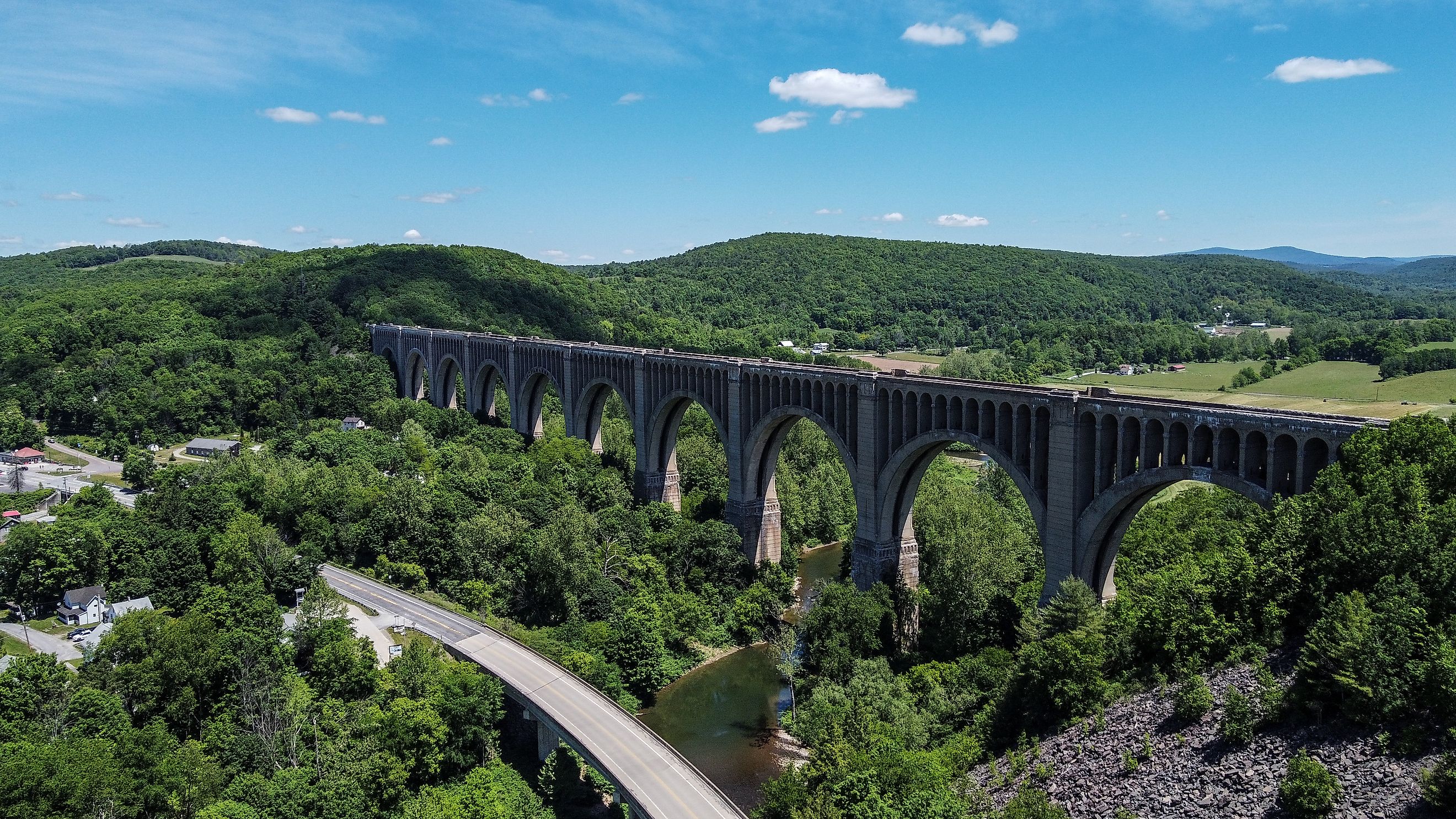
PA 92 threads 44 miles from Tunkhannock north to Lanesboro, about an hour, with a railroad bridge at each end. The road passes directly beneath the first one.
The Tunkhannock Viaduct does not stand at Tunkhannock. It crosses the valley at Nicholson, 20 minutes up the road, and locals call it the Nicholson Bridge. The Delaware, Lackawanna and Western Railroad opened it in 1915 after three years of work, to a design by A. Burton Cohen. The cutoff it belonged to shortened and straightened the main line between Scranton and Binghamton. It measures 2,375 feet and clears the creek by 240. Ten arches of 180 feet carry the deck, with a shorter buttress arch at either end, so 12 were built and 10 are visible.
Freight still crosses it. The American Society of Civil Engineers named it a National Historic Civil Engineering Landmark in 1975, and it went on the National Register in 1977.
The Starrucca Viaduct waits at the far end near Lanesboro, an older stone bridge that still carries track.
Penns Valley

PA 45 follows a private toll road east out of Boalsburg. The Bellefonte, Aaronsburg, and Youngmanstown Turnpike linked Buffalo Valley to Bellefonte in the 1820s. An earlier attempt chartered in 1810 had gone nowhere. Most of that road became this highway. The 25-mile run east to Woodward takes about 32 minutes on what the map still labels Penns Valley Road.
Ridges hold the valley open along its whole length. Centre Hall and Spring Mills pass early. Millheim follows, keeping a designated historic district, then Aaronsburg at the foot of Shriner Mountain. Woodward comes six miles east of Millheim.
Poe Valley and Poe Paddy state parks lie south of the valley, and reaching them means leaving US 322 near the top of Seven Mountains for unpaved forest roads. State park staff warn that winter access cannot be guaranteed on any approach.
PA 233 Through Michaux State Forest

PA 233 leaves US 30 at Caledonia State Park under the name Pine Grove Road. It reaches Pine Grove Furnace 13 miles above that junction, about 18 minutes. Michaux State Forest covers more than 85,500 acres around it. The rock underneath is the metavolcanic and quartzite of South Mountain, at the northern end of the Blue Ridge and the Appalachian Mountains.
The water running beside the road at Caledonia is not a stream. The millrace once turned the waterwheel for Thaddeus Stevens' iron furnace, which began work in 1837 and ran until 1870. The reconstructed stack and a blacksmith shop that keeps summer hours are both visible from the highway.
Pole Steeple Vista opens the view east across the forest from a quartzite outcrop. The Appalachian Trail Museum fills an old mill building at 1120 Pine Grove Road, near where the drive ends. The museum was the first in the country devoted to hiking, and it marks roughly the midpoint of a 2,197-mile footpath.
Five species of native pine grow together in the Meeting of the Pines Natural Area, the only place they do.
PA 372 And The Lower Susquehanna

Twenty-one spans of the Norman Wood Bridge carry PA 372 across the Susquehanna, and the overlooks facing it sit 380 feet higher. Quarryville lies 11 miles inland from Susquehannock State Park, a 19-minute drive. The park keeps a wooded plateau on the Lancaster County side.
Wisslers Run Overlook shows the river working over its natural rock bed, with the Muddy Run pumped storage plant in the foreground and the bridge and Holtwood Dam behind. Urey Overlook, across on the west bank, takes in Weise Island and the Safe Harbor Dam. The Mason-Dixon Trail passes it, 193 miles of blue blazes linking the Brandywine to the Appalachian.
Bald eagles, osprey, and vultures work the air below Hawk Point, which is the odd part of a river cliff. Spring and fall bring the heaviest migration.
Mount Johnson Island lies downstream and far to the left from that overlook, the first bald eagle sanctuary anywhere. The birds have since moved to an island just upstream.
Lebanon Cornwall Scenic Byway

Snow geese arrive in February. Middle Creek Wildlife Management Area, signed south of this byway, fills with them through early March. A paved half-mile path from the Willow Point lot reaches the water where the birds gather. Sunrise and sunset are when the lake holds them, before they scatter to feed and after they return. Tundra swans and ducks stay through the day. The visitor center closes from Thanksgiving until the Tuesday after Martin Luther King Day, which cuts across the opening weeks of the season.
The byway itself runs 14 miles along PA 419, from Quentin east through Cornwall to the Berks County line past Newmanstown, about 21 minutes across Lebanon County farmland.
Cornwall Iron Furnace stands on the road rather than off it. Peter Grubb lit it in 1742 and it burned until 1883, and the Historical and Museum Commission now calls it America's most complete charcoal-fueled iron-making complex. The ore body underneath was the largest iron-mining operation in the eastern United States until 1973. Tours run Friday through Sunday, the last one at 2 pm on Friday and Saturday.
PA 345 And French Creek

East of Cornwall, another furnace kept another forest, and PA 345 runs through what is left of it. The road covers the 5.8 miles from Birdsboro south to Hopewell Furnace in about nine minutes, the shortest drive here. French Creek State Park closes in from both flanks.
Mark Bird founded Hopewell in 1771. It cast pig iron, stove plates, kettles, and plowshares until 1883. Its stoves went out by the thousands on wagons. Charcoal burned from the surrounding hardwood kept it in blast, so the ironmaster owned the woods.
The federal government took the site in 1938 as Hopewell Village National Historic Site, one of the earliest cultural units in the park system. A 1985 renaming put the furnace back in the title. It still held roughly 6,000 acres through the Second World War. A postwar split left 848 acres in federal hands and the rest as the state park pressing in on three sides. That division drew the line the driver crosses between them.
Delaware River Valley Scenic Byway

Every view across the water from this road lands in New Jersey. The Delaware is an interstate river along its entire length. The byway climbs 17 miles up the Pennsylvania bank, from Easton north to Riverton opposite Belvidere. It uses PA 611, Little Creek Road, and the Belvidere Highway. Driven straight through, Easton to Riverton is 15 miles, roughly 24 minutes. The byway takes longer because it loops inland along Little Martins Creek before returning to the river.
No dam or control structure interrupts the main stem of this river. It runs 330 miles undammed from Hancock, New York to Delaware Bay, farther than any other free-flowing river east of the Mississippi. The Park Service counts it among the last large rivers in the lower 48 still running that way.
Farmland opens between highway and water along the northern half.
Where The Trees Give Way
None of these roads demand a full day behind the wheel. The shortest runs under six miles, and the longest reaches 44, leaving plenty of time to stop when the scenery opens up. Distance is not what makes them memorable. It is the stretches where Pennsylvania’s heavy tree cover gives way to something wider: a reservoir filling the horizon, a gorge dropping beneath the road, farmland opening across a valley, or a river running toward another state. The canopy eventually closes again, which makes those open views stand out even more.