10 Most Scenic Drives in Texas
Scenic drives in Texas span desert canyons and East Texas swamps. The Ross Maxwell Scenic Drive in Big Bend National Park ends at Santa Elena Canyon where limestone walls split the Rio Grande between two countries. Up in the Panhandle, historic Route 66 runs past Cadillac Ranch and the official midpoint of the whole route. In spring, the Willow City Loop in the Hill Country fills with bluebonnets. Caddo Lake delivers Spanish moss and alligators near the Louisiana border. Ten drives, and you still won't have seen all of Texas.
Davis Mountains Scenic Loop

Some people call the Davis Mountains the "Texas Alps." The Davis Mountains Scenic Loop runs 75 miles starting in Fort Davis. You can leave town on Highway 118 or Highway 17 (both run from town), loop around on Highway 166, and return via the other. Plan on a one-and-a-half to two-hour drive without stops. Early morning or late afternoon offers the best lighting and the best chances at wildlife. Along the loop, expect to see mule deer, aoudad, pronghorn, and javelina.
The scenery shifts side to side. One window has rolling grassland, the other has the mountains. The range itself is volcanic in origin and includes some of the highest peaks in Texas. On Highway 118, drivers pass the McDonald Observatory and Davis Mountains State Park, both worth a stop if you have time. The road is paved and conditions are generally good, but high winds are common.
Ross Maxwell Scenic Drive

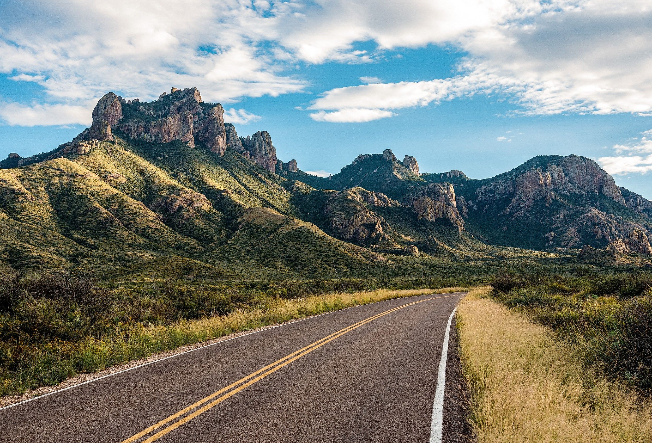
Inside Big Bend National Park, the Ross Maxwell Scenic Drive runs 30 miles between the main park road and the Rio Grande. From Panther Junction Visitor Center, head west and watch for the signed turnoff. The drive crosses Chihuahuan desert, river-carved canyons, and volcanic formations. The endpoint is Santa Elena Canyon, where 1,500-foot limestone walls rise on either side of the river. The wall on your right belongs to Mexico, and the wall on your left belongs to Texas.
There's plenty to see before you reach the canyon. The Sam Nail Ranch site holds an operating windmill, a shaded grove of pecan and walnut trees, and the remains of a 1916 ranch. Sotol Vista Overlook delivers wide views of the Chihuahuan Desert and the Chisos Mountains. Just down the road, Mule Ears Viewpoint takes its name from the twin volcanic dikes rising from the desert floor. Castolon Historic District near the end of the drive preserves the remnants of a former military camp and trading post (parts of the site burned in 2019 but the area remains accessible).
Twisted Sisters

The Twisted Sisters are three Hill Country roads (Ranch to Market 335, 336, and 337) that combine into one of the most challenging drives in Texas, popular with motorcyclists. The sharp turns, deep valleys, steep climbs, and big views are the draw. Most drivers start in Medina and run the loop, but you can pick up the route at any point.
The drive passes through small towns including Vanderpool, Leakey, and Camp Wood. Landscape varies from limestone cliffs to rolling hills to deep canyons. Wildflowers, wild turkeys, and white-tailed deer are common roadside sights. The loop crosses four river valleys (the Medina, Nueces, Frio, and Sabinal).
Texas Route 66

Texas holds 178 miles of historic Route 66, running east to west across the Panhandle from Shamrock to Glenrio at the New Mexico line. The drive is more about history and roadside attractions than landscape. Many of the surviving stops are listed on the National Register of Historic Places.

From Shamrock, the U-Drop Inn (also known as the Tower Conoco Station) is an Art Deco landmark built in 1936. Just east of Amarillo is Cadillac Ranch, the 1974 art installation by the Ant Farm collective featuring 10 Cadillacs (model years 1949 to 1963) buried nose down in a field. The town of Adrian is the official midpoint of the 2,448-mile Route 66 between Chicago and Santa Monica. Markers around town and Route 66 shields painted on the road mark the spot.
Willow City Loop

Spring is the best time to head to Fredericksburg and drive the Willow City Loop. This 13-mile route through the Hill Country is one of the premier wildflower drives in the state. From Fredericksburg, head north on Highway 16 about 13 miles, then turn onto Ranch Road 1323 and follow the signs. Most of the drive crosses private property, so stopping or parking along the road is discouraged. Avoid weekends if possible. At peak bloom, traffic can crawl bumper to bumper.
The setting (rolling hills, deep canyons) gives some of the best views of the state's pride and joy, the bluebonnet. From March through May, especially in a good wildflower year, the hillsides fill with blue, yellow, orange, and white. From the high points, you might spot bluebonnets, Mexican poppies, sunflowers, firewheels, and a dozen other wildflowers.
Devil's Backbone Road

Local legend follows Devil's Backbone Road. The 24-mile main stretch (Ranch Road 32, also called FM 32) runs along a limestone ridge in Central Texas, with the larger loop incorporating connecting routes between Wimberley, Blanco, San Marcos, and Canyon Lake totaling roughly 51 miles. Drivers should watch for elevation changes, sharp curves, and minimal shoulders. Spring brings prime Hill Country wildflower season, and fall brings golden foliage in the oaks and cypresses.

The elevated route delivers views of oak-lined valleys, blue ridges, and deep canyons. Many drivers come for the haunted history. Local legend has it that a woman walking the road carries her baby, searching for her husband. The Devil's Backbone Tavern in Fischer is a good stop for the local lore. The main stretch of FM 32 also has scenic overlooks and pull-offs. The limestone ridge between Wimberley and Blanco has long views down into the valley, and Canyon Lake is a good sunset spot.
Bluewater Highway

Along the Gulf of Mexico, the Bluewater Highway runs about 40 miles from Surfside Beach to Galveston Island. It begins at the intersection of Highway 332 and County Road 257 in Surfside Beach and ends in Galveston. Drivers get uninterrupted views of the rolling Gulf and sandy shore the whole way. Pelicans dive for fish and dolphins surface offshore. Christmas Bay along the route holds shorebirds and ducks.
The drive also passes the sand flats at San Luis Pass, a known spot to see magnificent frigatebirds. They are large seabirds with wingspans up to seven and a half feet. The best times for this drive are spring (for wildflowers) and fall (for the annual Monarch migration through coastal Texas).
Pineywoods Autumn Trail

The Pineywoods region in East Texas is best in November. Start in Athens on Highway 19 and head south toward Palestine, a 145-mile drive through pine-and-hardwood forest where the trees turn yellow, orange, and red.

Stops along the way include Lake Athens, Tara Vineyard and Winery (officially Sweet Dreams Winery at Tara), and the East Texas Arboretum near Athens. Bird diversity through the Pineywoods is high. Birdwatchers can look for prairie warblers, brown-headed nuthatches, and pileated woodpeckers, among many others. Palestine itself is the home of the Texas State Railroad, which runs vintage steam and diesel excursions through the forest.
Caddo Lake Drive

Along the Texas-Louisiana border is Caddo Lake, the largest naturally formed lake in Texas and home to one of the largest bald cypress forests in the world. Caddo Lake State Park sits on the Texas side at 245 Park Road 2 in Karnack. Once inside, drive past the park headquarters and pause for the area's history before the road winds deeper into the park. The route reaches Big Cypress Bayou, lined with bald cypress trees draped in Spanish moss. Wetlands and bayous edge the road, giving the place a quiet, almost eerie feel. The drive continues through thick forest, with the lake visible through the trees in places, then loops past the campground and trailheads before circling back.
With the bayous and wetlands come alligators, turtles, and herons. Some locals will tell you Bigfoot lives here too. Caddo Lake also has historic cabins built in the 1930s in Civilian Conservation Corps style.
Texas Bluebonnet Trail

Ennis is the official Bluebonnet City of Texas, designated by the state legislature in 1997. Each April, the town maps over 40 miles of driving routes through ranchlands and rolling hills filled with bluebonnets, the state flower. The blooms are wild, so they don't always show in the same places year to year. The Ennis Garden Club tracks current sightings and posts updates. These roads weave through ranchland around the town. Most of the bluebonnets are on private property, so don't trespass and definitely don't pick the flowers (it's not illegal but locals frown on it heavily).
The town divides the loops into three trails: West, North, and South. The West Trail starts at the Ennis Welcome Center, where you can pick up an updated map. Two parks along this trail (Bluebonnet Park and Ennis Veterans Memorial Park) let visitors walk among the flowers without trespassing. The West Trail covers the downtown area. The North and South trails wind through ranchland, where you'll see bluebonnets, horses in pasture, and ranch houses framed against the hills.
The Best of Texas
Around every corner of Texas there's something different. Remnants of a pioneer ranch in Big Bend, the official midpoint of Route 66, fields of bluebonnets in every direction. You could spend years here and only see a fraction. Limestone canyons, lava caps, alligators, wild turkeys, and (depending who you ask) Bigfoot. Texas is one of the most varied states in the country, with landscapes from forest to desert to canyon. The hardest part is choosing where to start.