13 Most Breathtaking Hikes In US National Parks
Thirteen hikes in the National Park System share one quality: the features they anchor on are older than the trails themselves. The Kīlauea Iki Trail crosses the still-warm floor of a 1959 lava lake. Half Dome climbs the final 400 feet of granite on steel cables installed in 1919. The Wonderland Trail circles 14,411-foot Mount Rainier in 93 miles. The through-routes on this list reach 211 miles. The day hikes drop under five. All of them deliver a view, a wall, a crater, or a piece of geology that has been waiting longer than any trail crew that built the path.
John Muir Trail, California

John Muir spent four decades arguing that Yosemite and the Sierra deserved federal protection, so the 211-mile through-route from Yosemite Valley to the summit of Mount Whitney carries his name. The trail tops out at 14,505 feet on Whitney, the highest point in the contiguous United States, and crosses eight named passes along the way, every one above 11,000 feet. Most through-hikers take two to three weeks. The Yosemite Wilderness Center runs the permit lottery 24 weeks in advance, with success rates under 30 percent for the most popular start dates. Resupply points sit at Red's Meadow Resort and Muir Trail Ranch. The food drop at MTR has to be packed and shipped weeks in advance; planning the resupply is half the work.
Highline Trail, Montana

The first third of a mile out of Logan Pass is the section everyone remembers. The Highline Trail in Glacier National Park traces the Garden Wall, a narrow shelf cut into the cliff face along the Continental Divide, with a steel hand cable bolted into the rock for the exposed opening stretch. The drop to the Going-to-the-Sun Road below runs several hundred feet straight down. The full point-to-point route covers 11.8 miles from Logan Pass north to The Loop, with most of the elevation loss in the final two miles. The side spur to the Grinnell Glacier Overlook at mile 7.6 adds 1.8 miles round trip and 1,000 feet of climb to the lip above the glacier itself. The trail opens mid-July through mid-September. Mountain goats and bighorn sheep work the meadows around Haystack Butte, and most hikers run the shuttle back from The Loop to Logan Pass rather than reverse the route.
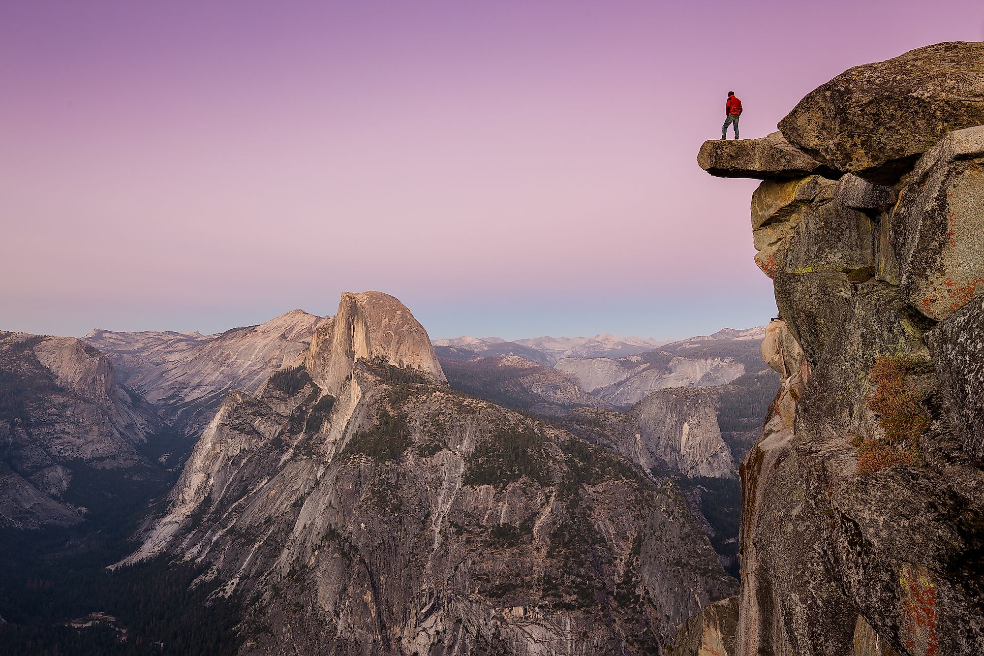
Half Dome, California

The cable section is what people remember. Two steel cables run up smooth granite at roughly 45 degrees, with wooden cross-boards every ten feet, climbing the back of the dome for the final 400 feet to the 8,839-foot summit. The full hike covers 14 to 16 miles round trip from Yosemite Valley with 4,800 feet of elevation gain, depending on whether the approach uses the Mist Trail or the John Muir Trail. The National Park Service first installed the cables in 1919 and runs them seasonally from late May through early October. A permit lottery caps cable days at 300 hikers per day. Standard advice: start before dawn, carry water for the full 14 miles, and skip the climb when afternoon thunderstorms are building. Lightning has killed people on this summit.
Wonderland Trail, Washington

Mount Rainier sits at 14,411 feet, the most heavily glaciated stratovolcano in the contiguous United States. The Wonderland Trail circles it in 93 miles with about 22,000 feet of cumulative elevation gain. Eighteen designated wilderness campsites along the loop run by advance reservation only, and most through-hikers take 10 to 14 days to complete it. The route crosses high alpine meadows at Spray Park and Indian Bar, glacier outwash plains at Sunrise and Mowich, and the old-growth rainforest belt of the western flank around Carbon River and Mowich Lake. Construction was completed in 1915 by the same generation that pushed for the establishment of Mount Rainier National Park, the fifth unit added to the system, in 1899.
Hoh River Trail, Washington

The Hoh Valley receives about 140 inches of rain per year, the wettest non-mountain location in the contiguous United States. The valley floor holds the densest stand of Sitka spruce, western hemlock, western red cedar, and Douglas fir anywhere in the lower 48. The Hoh River Trail in Olympic National Park runs 17.3 miles each way to Glacier Meadows, the base camp for Mount Olympus climbs. The first 13 miles trace the river on near-flat ground through cathedral-tall old growth. The last four climb hard to the meadow at 4,200 feet. Mount Olympus climbers and dedicated through-hikers handle the full distance. Day-hikers usually turn at Five Mile Island or Happy Four Camp.
Angels Landing, Utah

The final half-mile of Angels Landing in Zion National Park follows a knife-edge sandstone fin with 1,000-foot drops on both sides. The National Park Service has bolted chain handrails into the rock along the entire length. The full hike covers 5.4 miles round trip with 1,488 feet of gain. Permits have been mandatory since April 1, 2022, after a series of fatalities on the ridge and chronic overcrowding on the chains, and they run by daily and seasonal lottery through recreation.gov. Walter's Wiggles, the switchback section below the ridge, climbs 21 stacked turns up a sheer canyon wall in under half a mile. This is the trail that earns its name twice: once at the top, once on the way back.
Alkali Flat Trail, New Mexico

White Sands became the 62nd unit of the National Park System on December 20, 2019, redesignated by Congress from the national monument that Herbert Hoover had established in 1933. The Alkali Flat Trail runs about 5 miles in a loop across the heart of the dune field in the New Mexico Chihuahuan Desert. The dunes are gypsum, not silica sand. At roughly 275 square miles, the field is the largest gypsum dune system on Earth. The trail is marked by red metal diamond signs on tall fiberglass posts because the dunes shift across the route and any graded path would disappear inside a week. The "alkali flat" itself is the ancient floor of Lake Otero, the Pleistocene lakebed that produced the gypsum in the first place. The National Park Service recommends starting before 10 a.m. in summer. Surface temperatures on the gypsum reach the mid-90s by midday, there is no shade anywhere on the trail, and people get lost out here every year.
Rim-to-Rim, Arizona

The descent off the South Rim drops roughly 4,800 feet to the Colorado River at Phantom Ranch. The climb out the North Kaibab Trail regains about 5,800 feet to the North Rim. The full crossing of the Grand Canyon covers 21 to 24 miles point-to-point, depending on whether the south approach uses South Kaibab (21) or Bright Angel (24). Fewer than one percent of the canyon's roughly five million annual visitors complete the rim-to-rim. The standard logistics involve riding the Trans-Canyon Shuttle from the South Rim to the North Rim and hiking back across in one or two days. The Rim-to-Rim-to-Rim variant doubles the distance and is run as a single-push ultramarathon. The fastest known times sit under six hours.
Jenny Lake, Wyoming

The last Pinedale glaciation left a moraine across the eastern edge of Cascade Canyon about 12,000 years ago, trapped the meltwater behind it, and produced Jenny Lake at the base of the Tetons in Grand Teton National Park. The full lake loop covers 7.1 miles around the shore with modest elevation gain. The standard extension adds the Hidden Falls and Inspiration Point detour up Cascade Canyon, another two miles round trip and 500 feet of climb to the overlook at 7,200 feet. The Jenny Lake Shuttle Boat across the water cuts about four miles off the loop for hikers who want to skip the southern shore and head straight to the canyon access. The boat runs every 10-15 minutes in summer.
Lost Mine Trail, Texas

Big Bend National Park in West Texas earned International Dark Sky Park designation in 2012, with most of the park's interior measuring Bortle Class 1, the darkest reading the scale records. The Lost Mine summit overlook at 6,850 feet on the ridge above the Chisos Basin doubles as both a day-hike viewpoint over Mexico's Sierra del Carmen across the Rio Grande and a stargazing platform after dark. The trail runs 4.8 miles round trip with 1,100 feet of elevation gain on a wide, well-graded path that suits anyone with moderate fitness. Big Bend's remoteness is the practical filter on visitor numbers: the nearest commercial airport is four hours away in El Paso or Midland, which keeps the crowds off this overlook even at peak.
Precipice Trail, Maine

The Precipice Trail runs 1.6 miles up the east face of 1,058-foot Champlain Mountain in Acadia National Park, climbing roughly 1,000 feet on iron rungs, ladders, and narrow exposed ledges that the Civilian Conservation Corps cut into the granite cliff in the 1930s. The route is unsuited to anyone with a fear of heights, anyone hiking with children, or anyone hiking in wet weather. The full Precipice-to-summit-to-North Ridge loop covers about 2.2 miles. The National Park Service closes the trail from mid-March through mid-August each year to protect nesting peregrine falcons on the cliff face, a reintroduction program that began at Acadia in 1984 and produced the park's first wild nesting pair in 1991. Most climbers attempt the route in late August through October, when the trail reopens and the foliage on the carriage roads below is at peak.
Mount Eielson Loop, Alaska

Denali National Park does not maintain or blaze trails through most of its six million acres, which leaves hikers to navigate by topographic map and compass across open tundra and willow scrub. The Mount Eielson Loop circles 5,802-foot Mount Eielson over 14 to 17 miles, depending on the line chosen. The route starts and ends at the Eielson Visitor Center at mile 66 of the Park Road. Denali itself, at 20,310 feet the highest point in North America, sits 35 miles southwest and dominates the view on clear days, which arrive about one in three. Backcountry permits are mandatory and zone-specific, bear-resistant food canisters are required, and crossing braided glacial rivers is part of the route. This is one of the few mainstream-known hikes in the system with no marked path.
Kīlauea Iki Trail, Hawaii

Between November 14 and December 20, 1959, the pit crater of Kīlauea Iki on Hawaii's Big Island erupted in 17 lava fountains. The tallest reached 1,900 feet, the highest fountain ever recorded at Kīlauea. The eruption filled the crater floor with roughly 400 feet of pooled lava that took 35 years to fully cool. The Kīlauea Iki Trail in Hawaii Volcanoes National Park runs about four miles in a loop that drops 400 feet from the rim through ohia lehua forest, crosses the still-warm floor of the cooled lava lake, and climbs back out the far side past Nāhuku, the 500-year-old lava tube formerly known as Thurston. Steam fissures along the crater floor make the 1959 layer feel less geological and more recent than the date suggests. The trail's access depends on current volcanic activity. The park's alert page on the National Park Service website holds the current word on closures.
What Holds These Thirteen Together
Each of these routes rewards the visitor with something the trail itself cannot supply. The John Muir Trail crosses an unbroken stretch of alpine country that has held its shape since the Pleistocene. The Wonderland circles a stratovolcano that still steams in the right light. Rim-to-Rim cuts down through 1.7 billion years of canyon strata in a single day. The Alkali Flat Trail crosses a 275-square-mile gypsum dune field laid down by an evaporated Pleistocene lake. The day hikes pull the same trick at smaller scale. Lost Mine ends in Bortle Class 1 dark sky, Angels Landing ends on a knife-edge fin with 1,000-foot drops, Precipice climbs a CCC-cut iron-rung route up the east face of Champlain Mountain, and Kīlauea Iki walks across the floor of a lava lake that erupted in 1959. The trails are good. What carries them is older than the trails.