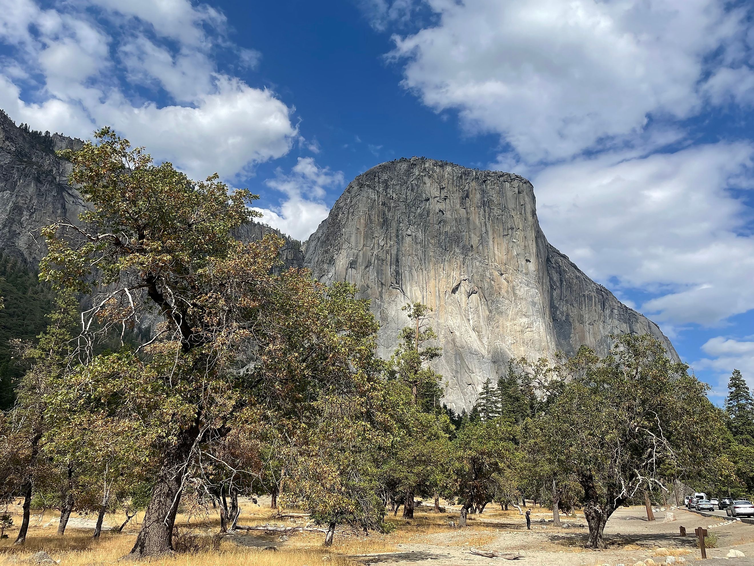
The Steepest Mountain In The United States
The steepest mountain in the United States is El Capitan, whose 3,000-foot granite face in Yosemite Valley stands essentially vertical. Measured by sustained height instead, Devil's Thumb in Alaska is the answer, with a 6,500-foot northwest face averaging 65° that no one has ever climbed. Notch Peak in Utah has the second-highest pure vertical drop in the country. Here are the peaks with the strongest claims, and the numbers behind each.
El Capitan

Sierra Nevada Range, California
Summit elevation: 7,569 ft (2,307 m). Southeastern face: 3,000 ft (914 m). Average slope: near vertical (90°).
El Capitan is an easy first choice as "Captain" of steep mountains in the United States. Located in the western part of Yosemite Valley, its surroundings include the Merced River running along its base, Bridalveil Fall, and Half Dome. About 3,000 feet of the tallest face is climbed, within a wall that rises roughly 3,600 feet overall. It is impossible to hike up El Cap. The formation is a sheer granite wall about half a mile high and a mile and a half wide. Long considered the mecca of American rock climbing, the monolith holds more than 100 established routes and variations, including the Nose, Freerider, West Face, East Buttress, Muir Wall, and Golden Gate. Warren Harding led the first ascent, reaching the top of the Nose in 1958 after 45 days of climbing spread across about 18 months. In 2017, Alex Honnold became the first, and so far only, person to free solo El Capitan, climbing the Freerider route with no rope or support from below. Charles "Butch" Farabee, a former Yosemite ranger and co-author of Off the Wall: Death in Yosemite, has counted 31 climbing deaths on El Capitan since 1905, 23 of them in falls. The American Alpine Club has logged 101 accident reports on El Capitan between 1974 and 2014.
Notch Peak

House Range, Utah
Summit elevation: 9,654 ft (2,943 m). Northwest face: 2,250 ft. Average slope: near vertical (90°).
Notch Peak is part of Sawtooth Mountain, just north of Highway 50 between Delta and Eskdale in western Utah. Its northwest face is the second-highest pure vertical drop in the United States, behind El Capitan, and the highest carbonate-rock cliff in North America. The peak is visible from as far as 70 miles away. The face runs about 1,500 feet in an unbroken stretch, then steps back on a bench before a second drop of roughly 750 feet. This portion of Sawtooth Mountain rises a full 4,000 feet from the desert floor to an overall elevation of 9,654 feet above sea level. Notch Peak Trail is a hiking approach from the east for those who want the view from the top without climbing the face. The peak has also become a popular wingsuit BASE jumping exit point and is featured as the iconic setting for companies like Limitless Flight. It is a carbonate cliff of 500-million-year-old limestone and dolomite, with pinkish-orange granite and monzonite forming additional bedrock at its base. Established climbing routes include Appetite for Destruction, Book of Saturday, Western Hardman, Eastern Softboy, and La Fin du Monde.
Devil's Thumb

Boundary Range, Alaska / British Columbia
Summit elevation: 9,077 ft (2,767 m). Northwest face: 6,500 ft (1,981 m). Average slope: 65°.
Devil's Thumb stands on the border between southeastern Alaska and British Columbia, along the Boundary Ranges of the Coast Mountains, near Petersburg. Named for its stark, jutting appearance, it is an extremely difficult climb even for expert mountaineers. Its steepest side, the Northwest Face, has never been scaled by humans and ranks among the last great unclimbed walls in North America. The peak is known as Taalkhunaxhkʼu Shaa in Tlingit, signifying a high place that could not be flooded. Catalogued as Boundary Peak 71, the mountain rises from the Stikine Icecap, a large icefield straddling the Alaska-British Columbia border that feeds the region's glaciers. Its average angle is a little gentler at 65°, but the Northwest Face is overwhelming in other ways. Its 6,500-foot height, glaciated ice features, unpredictable winds, avalanche danger, and freezing temperatures make it more forbidding than either El Cap or Notch Peak. While El Cap is closer to true vertical over a shorter span, Devil's Thumb has a larger area of sustained steepness, which makes it arguably the steeper mountain overall. Away from the Northwest Face, humans have reached the summit by a different approach, first when Fred Beckey, Bob Craig, and Clifford Schmidtke ascended in 1946. Craig went on to join the 1953 American expedition on K2, which failed to reach the summit. Nearby spires include the Witches Tits and Cats Ears, all of which make for a memorable skyline in this region.
Half Dome

Sierra Nevada Range, California
Summit elevation: 8,842 ft (2,695 m). Northwest face: 2,000 ft (610 m). Average slope: near vertical (90°).
Half Dome is the second candidate from the Sierra Nevada range, within Yosemite National Park on the eastern end of Yosemite Valley. It is composed of granite and quartz. The summit has a rounded dome shape that drops abruptly into the cliffside of its Northwest Face, a near-vertical wall of 2,000 feet and part of a section that stands 4,733 feet in all. The unusual shape came from glacial movement and freezing cracks that expanded and sheared away a large portion of the original rock, formed when magma cooled deep underground. The eastern approach to the summit can be hiked rather than climbed and is known for a final 400-foot stretch so steep that a cable-supported route serves as a safety measure. Half Dome has a confirmed record of 29 deaths and two more probable deaths between 1930 and 2015, according to Gregory Richardson and Susanne Spano's 2018 study, Death on the Dome. Technical rock climbing accounted for the most deaths, with suicides second, and the remainder split among falls on the cables, hiking, lightning, and BASE jumping. The first person credited with climbing the dome side of Half Dome was George Anderson, a Scottish mountaineer, who reached the top on October 12, 1875. The Northwest Face was first climbed by Mike Sherrick, Jerry Gallwas, and Royal Robbins on June 28, 1957. Vernal and Nevada Falls are popular nearby features reachable by day-hike trails.
Mount Hooker

Wind River Range, Wyoming
Summit elevation: 12,504 ft (3,811 m). North face: 1,800 ft (549 m). Average slope: near vertical (90°) with hyper-vertical overhangs.
Mount Hooker straddles the Continental Divide at a remote spot 15 to 20 miles from the nearest road. Most approaching hikers begin at the Big Sandy Opening and walk the rest of the way. The final leg to the peak is an easy grassy stroll of a few hundred feet, once a climber has topped the steep North Face, an 1,800-foot slab of granite. That walk-off was discovered by Royal Robbins, Dick McCracken, and Charlie Raymond, the first known party to climb the face, in July 1964. In the early 1990s, Todd Skinner free climbed the North Face via the Jaded Lady route. Senderoso Luminoso, Royal Flush, Shady Lady, and Original Sin are among the other demanding routes on Hooker, all of them for experts only. Skinner went on to start Wyoming's first International Climbers' Festival in 1994, held in nearby Lander, about 30 miles east as the crow flies. One philosophical point he raised about free climbing was the idea of not altering the terrain with bolts, ropes, or cables, but instead adapting oneself to whatever an organic ascent demands. Hooker's climbing terrain includes numerous granite cracks and overhanging fissures, which make it especially dangerous and different from many of the smoother steep faces on record. The wilderness is thick around Mount Hooker, and bears are a concern for anyone camping in this region.
Baring Mountain

Cascade Range, Washington
Summit elevation: 6,127 ft (1,868 m). Northeast face: 2,460 ft (750 m). Average slope: 72° (a 2,460 ft drop over 820 ft of horizontal distance) with periodic vertical 90° segments.
Known as Mount Index before a 1917 renaming, Baring Mountain rises above the Mt. Baker-Snoqualmie National Forest in the Wild Sky Wilderness of northwestern Washington, with Barclay Lake at its base. The steepest side is the Northeast Face of its higher north summit, the usual climber's objective, and the peak has a double summit. A 2.2-mile trail to Barclay Lake offers ground-up views of the entire mountain. John Charlton and Albert Sylvester made the first recorded ascent in July 1897, though the standard route was likely hiked by earlier Native American scouts. Dirtbag pioneers Ed Cooper and Don Claunch recorded the first ascent of the Northeast Face in July 1960. In the 21st century, the face became a focus for the newer sport of BASE jumping, in August 2001 (Todd Higley and Josh Whipple), and for wingsuit jumping, in June 2004 (Michael McMurtrey). Four fatalities have been documented from these activities so far. The mountain is a mix of meta-andesite, dacite, and volcanic breccia, which is far more brittle and loose than the hard granite of the California peaks. Moisture is another obstacle, since this is a temperate rainforest zone with heavy rainfall. Other Washington mountains with competing steep claims include Needle Peak at 7,900 feet, with an overall average slope near 40°, and South Hozomeen Mountain at 8,003 feet, with an average slope near 42°.
Longs Peak

Front Range, Colorado
Summit elevation: 14,259 ft (4,346 m). East face: 900 ft. Average slope: near vertical (90°) with overhangs at about 95°.
The steep face of Longs Peak is the Diamond, or East Face, which shoots straight up for 900 feet at an already considerable height of about 13,000 feet. Longs Peak sits in the Front Range within Rocky Mountain National Park, which covers 265,807 acres of northern Colorado. Chasm Lake lies along the base of this glacier-carved mountain. Mills Glacier, a remnant icefield at the foot of the wall, lies below climbers working the overhangs that stretch for several hundred feet within the crevices of the Diamond. Permission to climb the Diamond was first sought in 1954 and met with a flat refusal, and park officials kept the peak off-limits for several years. That changed after August 3, 1960, when Dave Rearick and Bob Kamps made it up the Diamond along the D1 route with a crowd watching and cheering below. Later routes included the Casual Route, Pervertical Sanctuary, Yellow Wall, D7, and Curving Wall. In 2007, Steph Davis became the first woman to free solo the Diamond, climbing the Casual Route and Pervertical Sanctuary each twice in one summer. For hikers not interested in technical climbing, the Keyhole Route goes up the western flank of Longs Peak. After squeezing through a keyhole-like aperture, hikers face 40° inclines along the Ledges, narrow rock slabs made more ominous by the 1,000 feet of drop below into Glacier Gorge.
Mount San Jacinto

San Jacinto Range, California
Summit elevation: 10,834 ft (3,302 m). North face: 9,634 ft. Average slope: about 40°, sustained over roughly 4.5 miles.
Mount San Jacinto sits in Southern California between Idyllwild and Palm Springs. At first glance it might not seem that steep, with an average angle of 40° above the horizontal on the North Face above Snow Creek, compared with El Capitan's near-vertical pitch. Here, though, the metric is total vertical relief sustained over a long distance. Another factor sits above the North Face: the Wall of Thorns, an almost impenetrable chaparral zone of manzanita and cholla, and then a band of icy rock slabs toward the top. San Jacinto is the highest point in the San Jacinto Range. A study hosted by the California Department of Fish and Wildlife describes it as "the steepest escarpment in North America." The first recorded ascent to the peak is credited to "F. of Riverside" in 1874, according to an account in the San Diego Union. The first climb of the North Face went to Floyd Vernoy and Stewart White in 1931. The Palm Springs Aerial Tramway is a popular way to take in views of San Jacinto without the dangers of hiking and climbing. The tram runs up to Mountain Station, at an elevation of 8,516 feet, where visitors find observation decks, a state parks visitor center, natural history exhibits, and restaurants, all at this extreme altitude.
The Earth in BASE
This piece has weighed steepness across several categories of US mountains, whether judged by observation, hiking, climbing, or jumping. One of the wonders of the modern world is that leaping off mountains has become a globally popular pastime. The term BASE jumping was coined by filmmaker Carl Boenish in 1978 and stands for jumps made from one of four fixed points: Buildings, Antennae, Spans (bridges), and Earth. Among the steepest mountains in the United States, these peaks all qualify as Earth. The Wellsville Mountains of northern Utah are often called the steepest range in the country, but that claim is incorrect; it measures how narrow the range is rather than how steep, and the Wellsville flanks average only about 20°, nowhere near a vertical face. If the numbers and slope-angle calculations seem a little complex, a good rule of thumb for steepness might simply be a mountain you could jump, or fall, from. If you can, it is steep.