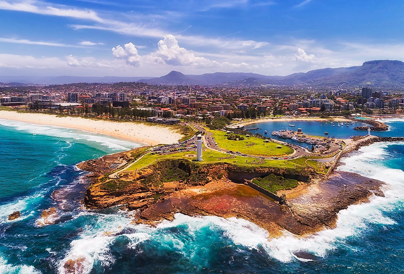
10 Largest US Islands
No two islands are identical. Most islands were historically connected to the mainland, resulting in their environmental characteristics often reflecting those of their respective regions. For example, the islands of Alaska exhibit a colder, humid climate consistent with the state's overall conditions, whereas the Hawaiian Islands are characterized by a combination of tropical and arid climates. However, the inherently smaller size of islands and their complete encirclement by water impart distinctive traits. Furthermore, an island's geographical location significantly influences its physical features, human activities, and environmental dynamics.
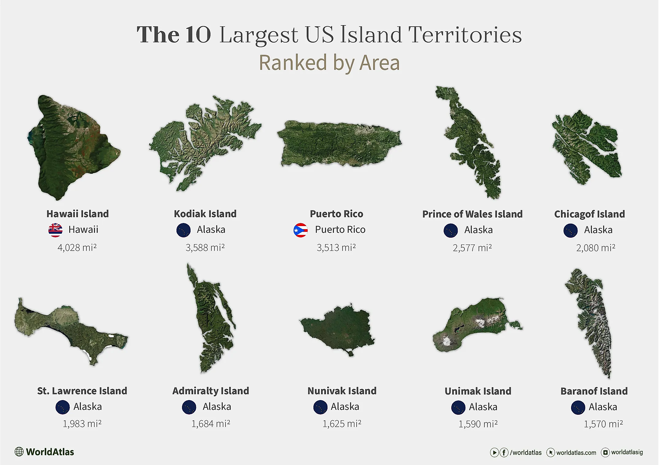
The largest United States Island is Hawaii Island at 4,028 mi2. Following behind it are Kodiak Island, Puerto Rico, and Prince of Wales Island at 3588 mi2, 3513 mi2, and 2577 mi2, respectively. Massive geologic features that are common to these ten islands include mountains with elevations over 1,200 miles, as well as dramatic fjords and bays that cut into the landscape itself.
The 10 Largest US Islands Ranked By Area
| Rank | Island's Name | Area (mi2) | Location |
|---|---|---|---|
| 1 | Hawaii Island | 4,028 | Hawaii |
| 2 | Kodiak Island | 3,588 | Alaska |
| 3 | Puerto Rico | 3,513 | Puerto Rico |
| 4 | Prince of Wales Island | 2,577 | Alaska |
| 5 | Chichagof Island | 2,080 | Alaska |
| 6 | St. Lawrence Island | 1,983 | Alaska |
| 7 | Admiralty Island | 1,684 | Alaska |
| 8 | Nunivak Island | 1,625 | Alaska |
| 9 | Unimak Island | 1,590 | Alaska |
| 10 | Baranof Island | 1,570 | Alaska |
1- Hawaii Island - 4,028 mi2

The Hawaiian chain's "Big Island" formed a little less than 500,000 years ago, making it the youngest in the group. A hotspot, a fixed plume of mantle material, formed the islands as the Pacific Plate glided over it, like a stationary piping bag dropping frosting on a rotating cake. The volcano that formed Hawaii Island, Mauna Loa, is the largest subaerial volcano on Earth by mass and volume; subaerial simply means a volcano that erupts above the Earth's surface, on land, rather than underwater or beneath ice.
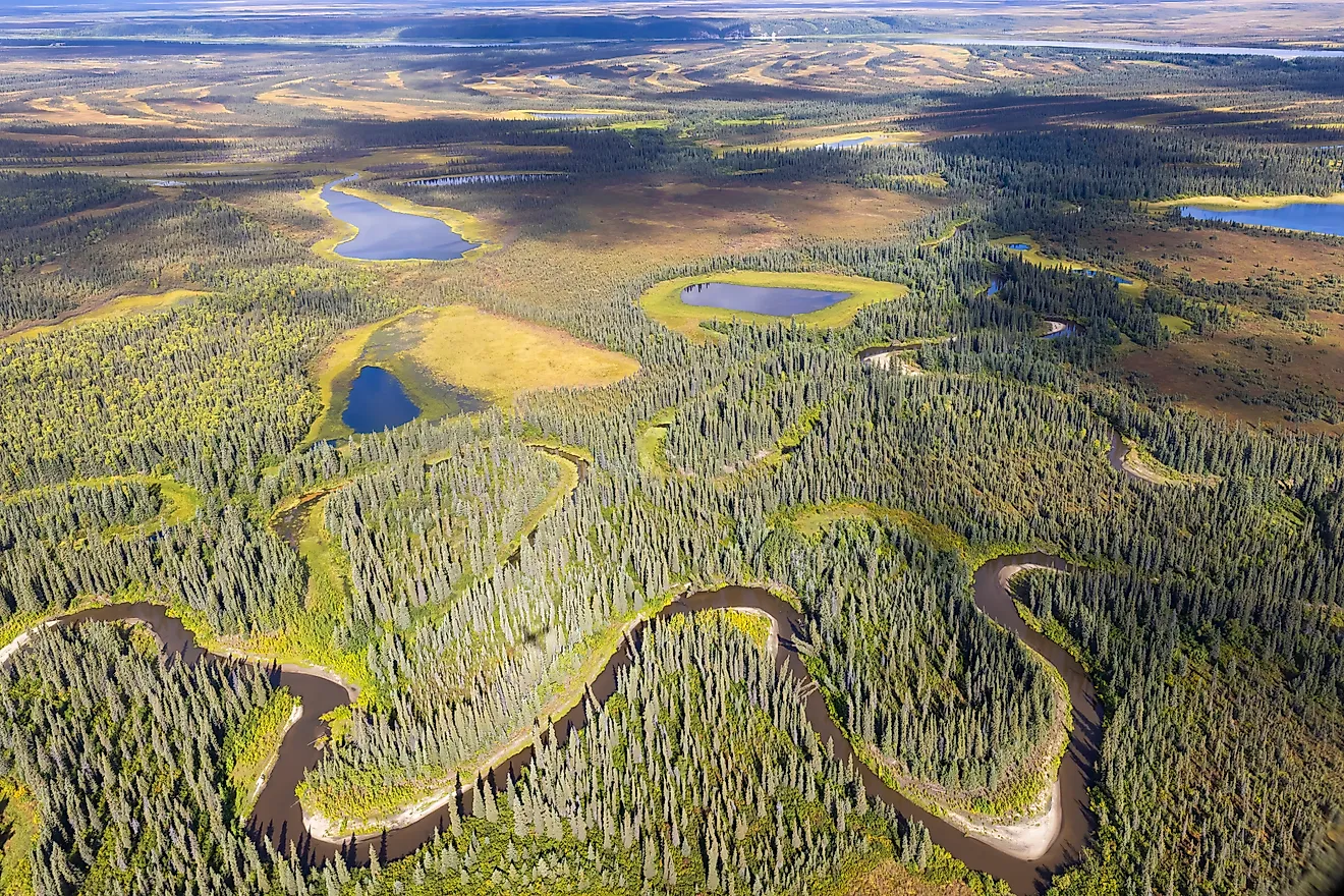
2- Kodiak Island - 3,588 mi2

Kodiak Island, the second-largest island in the United States, lies off the southern coast of Alaska. Like the majority of islands on this list, it was shaped by tectonic uplift and glacial activity over millions of years. Peaks exceeding 4,000 feet tower above dense forests in the north and east, while the southern regions remain barren and windswept. Kodiak’s coastline is made up of deep fjords and inlets carved by retreating glaciers, supporting one of the richest marine ecosystems in the world. Despite its size, human settlement is sparse, concentrated primarily in the city of Kodiak, with a population of around 6,000.
3- Puerto Rico - 3,513 mi2

Although Puerto Rico is the smallest and easternmost island of the Greater Antilles, it spans 3,513 mi2, making it the third-largest US island. Formed millions of years ago at the boundary of the Caribbean and North American tectonic plates, it features the Cordillera Central, a central mountain range with peaks exceeding 4,300 feet. Its topography includes karst landscapes and over 300 beaches along its extensive coastline. Unlike the geologically younger Hawaiian islands, Puerto Rico’s formation is linked to plate convergence rather than a volcanic hotspot. Finally, Puerto Rico's size supports over 3 million residents, and its central Caribbean location was extremely useful to Spain before it became a US territory in 1898.
4- Prince of Wales Island - 2,577 mi2

Prince of Wales Island, a mountainous landmass in southeastern Alaska, lies north of the Hecate Strait. It is heavily forested, with notable limestone formations and caves, including the El Capitan Pit, one of the deepest vertical shafts in the U.S. Steep mountains, often over 3,800 feet tall, dominate the terrain, while dense temperate rainforests cover much of it. Its rugged, highly indented coastline is dotted with numerous inlets and bays, supporting rich marine ecosystems. The island's low human population has helped maintain its pristine natural environments.
5- Chichagof Island - 2,080 mi2

Chichagof Island is part of Alaska's Alexander Archipelago, and its surface is marked by sharp elevations and numerous water channels, creating a network of fjords and bays that slice into its landmass. The island lies near the eastern edge of the Pacific Ring of Fire, and with 741 miles of shoreline, it is perpetually threatened by tsunamis and other seismic activity in the region. For example, in 1927, a magnitude 7.1 earthquake struck the northern section of Chichagof Island, disrupting the environment and affecting the Hoonah population, which was likely around a thousand people at the time.
6- St. Lawrence Island - 1,983 mi2

The Bering Sea, 36 miles east of Russia, is home to St. Lawrence Island. Believed to be a remnant of the Bering Land Bridge from the Pleistocene epoch, the island may have once been traversed by the original populations who first inhabited North and South America. The island's terrain includes tundra and volcanic features, with its highest elevation reaching 2,066 feet at Atuk Mountain. Interestingly, the island is still home to the Siberian Yupik people, who have sporadically settled there in the last 2,000 years.
7- Admiralty Island - 1,684 mi2

Alaska's Alexander Archipelago is home to another mention on this list, Admiralty Island. The island stretches about 90 miles in length and 34 miles in width, and it possesses elevations measuring up to 4,650 miles. The island is nearly bisected by the 39-mile-long Seymour Canal, with the extremely remote Glass Peninsula extending to the east. Around 90% of Admiralty Island is protected by the Kootznoowoo Wilderness Preservation, which allows old-growth forests to thrive. Better yet, the island is famous for remaining home to bald eagles and a massive population of 1,600 brown bears, giving it one of the highest concentrations relative to anywhere else in the world.
8- Nunivak Island - 1,625 mi2

Situated about 30 miles offshore from the Yukon River delta in Alaska, Nunivak Island is formed out of a volcanic plateau rising over 524 feet above sea level. The island hosts around 60 cinder cones and four maars, with widespread thin pahoehoe lava flows originating from small shield volcanoes. These geological points of interest are evidence of volcanic activity that began approximately 6.1 million years ago. A herd of 4,000 reindeer, first introduced in 1920, roams the island alongside indigenous inhabitants. There are also a number of great shaggy musk oxen that originate from Greenland after the Alaskan musk ox became extinct in the 1800s.
9- Unimak Island - 1,590 mi2

Unimak Island, the largest in Alaska's Aleutian chain, spans 1,590 square miles. It features Mount Shishaldin, a highly active volcano rising to 9,373 feet, noted for its near-perfect conical shape. The island also contains Fisher Caldera, a significant volcanic crater measuring about 6.8 by 11.1 miles, formed by a massive eruption around 9,100 years ago. Unimak's geological activity is part of the Aleutian Arc, where the Pacific Plate subducts beneath the North American Plate, leading to frequent seismic events. Population-wise, the last census recorded roughly 35 people occupying the island in 2010.
10- Baranof Island - 1,570 mi2

Baranof Island's terrain includes Mount Bassie, which rises to 4,301 feet, and Mount Furuhelm at 3,622 feet. The island also has numerous lakes, such as Baranof Lake and Blue Lake, and rivers, including the Baranof and Indian Rivers. Historically, the island was named by an Imperial Russian Navy captain in honor of Alexander Andreyevich Baranov, the first governor of Russian America from 1799 to 1818. In 1867, the island was purchased by the United States from Russia as part of the Alaska Purchase. In 1910, Baranof Island became a national monument, and in 1972 it was designated a national historical park.
Each US Island territory is a story of the country's historical growth and unique politics, the memories of the Indigenous persons who often still inhabit those lands, and the cataclysmic geological forces that first formed each island. Whether by hotspot or tectonic plate, each island is part of larger natural movements that continue to either create new islands or shape these islands. In the distant future, on the scale of millions of years, these islands may change significantly in size and appearance, and some may vanish into the ocean altogether.
The Largest Islands In The United States Of America (over 75 square miles)
| Rank | Island's Name | Area (mi2) | Location |
|---|---|---|---|
| 1 | Hawaii Island | 4,028 | Hawaii |
| 2 | Kodiak Island | 3,588 | Alaska |
| 3 | Puerto Rico | 3,513 | Puerto Rico |
| 4 | Prince of Wales Island | 2,577 | Alaska |
| 5 | Chichagof Island | 2,080 | Alaska |
| 6 | St. Lawrence Island | 1,983 | Alaska |
| 7 | Admiralty Island | 1,684 | Alaska |
| 8 | Nunivak Island | 1,625 | Alaska |
| 9 | Unimak Island | 1,590 | Alaska |
| 10 | Baranof Island | 1,570 | Alaska |
| 11 | Long Island | 1,401 | New York |
| 12 | Revillagigedo Island | 1,145 | Alaska |
| 13 | Kupreanof Island | 1,086 | Alaska |
| 14 | Unalaska Island | 1,051 | Alaska |
| 15 | Nelson Island | 843 | Alaska |
| 16 | Kuiu Island | 758 | Alaska |
| 17 | Maui | 727 | Hawaii |
| 18 | Afognak | 698 | Alaska |
| 19 | Umnak | 692 | Alaska |
| 20 | Oahu | 597 | Hawaii |
| 21 | Kauai | 552 | Hawaii |
| 22 | Atka Island | 410 | Alaska |
| 23 | Attu Island | 346 | Alaska |
| 24 | Etolin Island | 336 | Alaska |
| 25 | Montague Island | 305 | Alaska |
| 26 | Adak Island | 280 | Alaska |
| 27 | Molokai | 260 | Hawaii |
| 28 | Dall Island | 253 | Alaska |
| 29 | Wrangell Island | 216 | Alaska |
| 30 | Mitkof Island | 211 | Alaska |
| 31 | Padre Island | 209 | Texas |
| 32 | Guam | 209 | Guam |
| 33 | Isle Royale | 206 | Michigan |
| 34 | Tanaga Island | 204 | Alaska |
| 35 | Zarembo Island | 185 | Alaska |
| 36 | Unga Island | 177 | Alaska |
| 37 | Amlia | 176 | Alaska |
| 38 | Hinchinbrook Island | 170 | Alaska |
| 39 | Kosciusko Island | 169 | Alaska |
| 40 | Whidbey Island | 169 | Washington |
| 41 | Kruzof Island | 168 | Alaska |
| 42 | Kanaga Island | 142 | Alaska |
| 43 | Lanai | 141 | Hawaii |
| 44 | St. Matthew Island | 137 | Alaska |
| 45 | Annette Island | 132 | Alaska |
| 46 | Akutan Island | 129 | Alaska |
| 47 | Drummond Island | 125 | Michigan |
| 48 | Hagemeister Island | 120 | Alaska |
| 49 | Nagai Island | 120 | Alaska |
| 50 | Amchitka | 119 | Alaska |
| 51 | Sitkalidak Island | 119 | Alaska |
| 52 | Mount Desert Island | 108 | Maine |
| 53 | Kiska | 107 | Alaska |
| 54 | Knight Island | 101 | Alaska |
| 55 | Marsh Island | 100 | Louisiana |
| 56 | Santa Cruz Island | 98 | California |
| 57 | Gravina Island | 95 | Alaska |
| 58 | Martha's Vineyard | 91 | Massachusetts |
| 59 | Agattu | 90 | Alaska |
| 60 | Semisopochnoi Island | 86 | Alaska |
| 61 | Johns Island | 84 | South Carolina |
| 63 | Saint Croix | 84 | U.S. Virgin Islands |
| 62 | Seguam Island | 83 | Alaska |
| 64 | Yakobi Island | 82 | Alaska |
| 65 | Santa Rosa Island | 81 | California |
| 66 | Raspberry Island | 77 | Alaska |
| 67 | Douglas Island | 77 | Alaska |
| 68 | Santa Catalina Island | 75 | California |