What Were the Ancient Supercontinents?
Massive sections of the world have "floated" on a layer of liquid rock for billions of years. Occasionally, ongoing plate movement means that these sections group together above the waves and comprise all or most of the planet's land; these are called 'supercontinents,' and Africa and Asia currently fit this definition. These supercontinents are typically in-between "superoceans" (an ocean larger than today's Pacific Ocean). Evidence for these landmasses comes from mineral and geologic patterns, the predictable movement of the current tectonic plates, and even similarities between flora and fauna that, based on today's world, should have no ancestral connections.
Ancient Supercontinents
- Pangaea
- Gondwana And Laurasia
- Pannotia
- Rodinia
- Columbia (Nuna)
- Atlantica
- Arctica
- Kenorland
- Ur
- Vaalbara
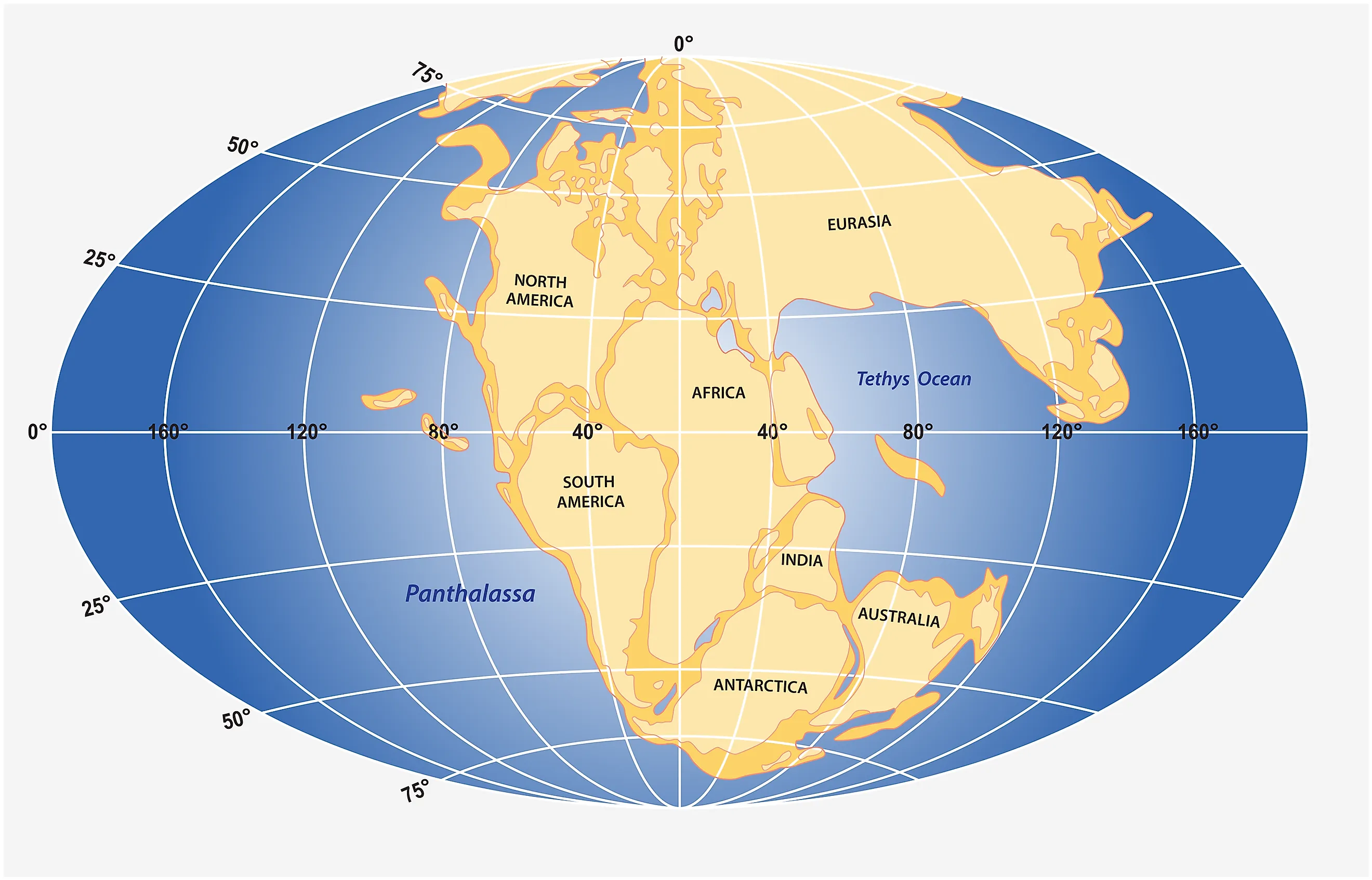
Pangaea

Pangaea was a supercontinent that existed during the late Paleozoic and early Mesozoic eras, approximately 336 million years ago. Pangaea is from the Greek words pan, meaning "entire," and "gaia," meaning "earth." Alfred Wegener proposed the existence of Pangaea in the early 20th century based on evidence from geology, paleontology, and continental drift. Supercontinents like Gondwana and Laurasia combined with the Siberia landmass, resulting in Pangaea.
A single large ocean called Panthalassa surrounded Pangaea. The formation of Pangaea had significant impacts on Earth's climate and biota: It created vast deserts in the center of the continent due to its distance from the ocean, while coastal areas experienced humid climates.
The breakup of Pangaea began around 200 million years ago, leading to the formation of the separate continents currently on Earth. This process also caused massive volcanic eruptions and earthquakes, which shaped Earth's current geological features.
Gondwana And Laurasia

Gondwana held its place on Earth from the Neoproterozoic period to the Jurassic period, approximately 550 million to 180 million years ago. It was formed by colliding several smaller continents and fragments, including South America, Africa, Madagascar, India, Australia, and Antarctica. The name "Gondwana" comes from the Gond tribe of central India.
During its existence, Gondwana underwent several tectonic events that shaped its geography and influenced biodiversity. One of the most significant events was the separation of Africa from South America during the early Cretaceous period, which led to the formation of the Atlantic Ocean.
The Gondwana supercontinent played a crucial role in the evolution and distribution of flora and fauna across different regions. Fossil evidence suggests it was home to many unique species, such as dinosaurs, marsupials, and early flowering plants. Today, remnants of Gondwana are in various parts of the world, including South America's Andes Mountains and Africa's Karoo Basin.
Laurasia was the landmass that together with Gondwana formed Pangaea. The two landmasses seaparated about 215 to 175 million years ago. Laurasia moved northwards to finally split into smaller landmasses with the formation of the North Atlantic Ocean about 56 million years ago.
Pannotia

Pannotia, also known as the Vendian supercontinent, was a hypothetical supercontinent that existed during the Neoproterozoic era. It formed approximately 633 million years ago and lasted until around 573 million years ago, breaking apart to create unique features on the continents we know today. Geologists proposed the concept of Pannotia in the early 1990s based on geological and paleomagnetic evidence.
Pannotia was at the South Pole, and a global ocean, which had surrounded the earlier Rodinia, enclosed the landmass, which is how it first formed. The supercontinent consisted of present-day South America, Arabia, Antarctica, Australia, and parts of Asia.
The breakup of Pannotia contributed to the formation of new oceans, such as the Iapetus Ocean and the Proto-Tethys Ocean. The separation also triggered significant evolutionary events, including the Cambrian explosion, which saw increased biodiversity.
Rodinia

Rodinia was another supercontinent that existed approximately 1.1 billion years ago during the Neoproterozoic era. It was another potential precursor to the better-known Pangea. The continent formed through collisions between smaller land masses, eventually covering almost one-third of the planet's surface. It was one of the first Precambrian supercontinents identified and was named Pangaea I at first.
The vast landmass altered ocean currents, leading to changes in sea level and weather patterns. The continent also provided new habitats for early life forms, allowing for diversification and evolution.
Geologists need to learn more about Rodinia despite its significance due to limited geological evidence. Scientists continue to study the matter using various methods, including seismic imaging and computer modeling.
Columbia (Nuna)

Columbia, also known as Nuna, is believed to have been one of the first supercontinents on Earth, and it played an essential role in the planet's geological history. It existed approximately 1.8 billion years ago.
Geologists believe that Columbia formed, from colliding landmasses, thanks to evidence provided by geological and paleomagnetic data. This process of collision and convergence led to the formation of some of the oldest rocks on Earth.
Columbia spanned across what is now North America, South Africa, India, Australia, and parts of Antarctica. It lasted for about 500 million years before it began to break apart due to plate tectonic activity.
The breakup of Columbia led to the formation of new oceans and continents, such as Laurentia, Baltica, Siberia, and Amazonia. This event also significantly impacted the evolution of life on Earth as it created new habitats for organisms to thrive in.
Atlantica

Atlantica was formed by the collision of several smaller land masses, including what is now West Africa, Brazil/Amazonia, and the Congo. Conservative estimates place Atlantica between 1.9 and 1.1 billion years ago, somewhere in the southern hemisphere.
The formation of Atlantica had a significant impact on the planet's geology and climate: the collision of the land masses caused massive volcanic activity and mountain-building, which led to changes in sea levels and ocean currents.
Arctica
Arctica, the ancient supercontinent of the Paleoproterozoic era, was a landmass encompassing much of current North America, Greenland, and parts of Europe. This massive continent formed through collisions between smaller continental blocks approximately 2.1 billion years ago.
Because of its age, the supercontinent was hard to pin down until geologists proposed that the current Arctic region was influenced by tectonic movements that joined several different continental nodes. Arctica ended around 1.9 billion years ago when it began to break apart and eventually split into several smaller continents, leaving evidence in Laurentia, Baltica, and Siberia.
Kenorland

Kenorland existed over 2.7 billion years ago and is likely one of the earliest known supercontinents. It was formed by the collision of several smaller continents, including what is now North America, Greenland, and parts of Asia and Africa. Kenorland's formation depended on accretion events, and these dramatic movements are evidenced in greenstone belts (layers of metamorphic rock) in a region of modern-day Australia.
Geologists named the continent after the Kenoran orogeny, a period of intense mountain-building activity during its formation. This event also created vast mineral deposits that play a significant role in today's industry. As is the fate of all supercontinents, tectonic activity eventually broke Kenorland apart.
Ur

Ur, the hypothetical supercontinent that existed approximately 2.8 billion years ago, is a subject of great interest to geologists and scientists. The name Ur comes from the German prefix for "original." However, despite being theorized as the only continent above sea level then, it was likely smaller than today's Australia.
It was a relatively young landmass with few mountains or other significant geological features. This quality is understandable because Earth has had to undergo countless events to have its current features. Ur's last remnants are currently seen in India in several regions based on geologic evidence in comparable rock layers.
Vaalbara

Vaalbara is a hypothesized supercontinent that existed approximately 3.6 billion years ago during the Archean Eon. Its existence appears in geological evidence, such as similar rock formations and isotopic ratios found in Western Australia, South Africa, and Eastern Antarctica. An asteroid impact that occurred billions of years ago left small glassy spheres at one location, which are now found worldwide - and this is the primary evidence for the existence of Vaalbara.
The name "Vaalbara" derives from the cratons (chunks of Earth's crust at the center of a continent) to which it was related to. Like most of these supercontinents, it took a series of collisions by smaller landmasses to form Vaalbara.
Studying ancient supercontinents provides valuable insights into the Earth's geological history and helps humanity understand how the planet has evolved over millions of years. Through research and analysis, scientists have been able to identify several supercontinents that have existed in the past, including Pangaea and Rodinia. By examining the movement and breakup of these land masses, geologists can better understand plate tectonics and how they continue to shape the world today. One day, this study may lead to accurate prevention systems for tragedies like earthquakes which operate on similar principles.


