Michigan's Most Charming Beach Towns
Michigan has more freshwater shoreline than any other state, two peninsulas, and four Great Lakes for borders. The eleven towns below trade on different parts of that coastline. The wide white-sand beaches of the southwest corner. The dune-walled bays of the Lower Peninsula. The working harbors at the river mouths. The rocky shorelines of the Keweenaw, where mining ran before tourism did. Each town below earns the list because the lake is a daily fact, not a backdrop.
Traverse City

Traverse City sits at the foot of Grand Traverse Bay and runs as the regional hub for northern Michigan, with about 15,000 residents and miles of shoreline along the bay's twin arms. The town is the eastern gateway to Sleeping Bear Dunes National Lakeshore, where dunes rise more than 450 feet above Lake Michigan and Good Morning America viewers voted the park "the most beautiful place in America" in 2011. Downtown Front Street keeps a working main strip of bookstores, brewpubs, and tasting rooms tied to the surrounding Old Mission and Leelanau wine peninsulas, which produce most of the state's award-winning Riesling.
Holland

Founded by Dutch immigrants in 1847, Holland sits on the eastern shore of Lake Michigan at the mouth of the Black River. Windmill Island Gardens runs De Zwaan, a working Dutch windmill that was milling grain in the Netherlands as far back as the 1760s before being shipped to Holland and reassembled in 1964 (it remains the only authentic, operating Dutch windmill in the United States). Six million tulips go in across the city each spring for the Tulip Time festival in May, drawing more than 500,000 visitors over its run. Holland State Park and Tunnel Park run the lakeshore for swimming and dune walks, and the Big Red Lighthouse anchors the harbor entrance.
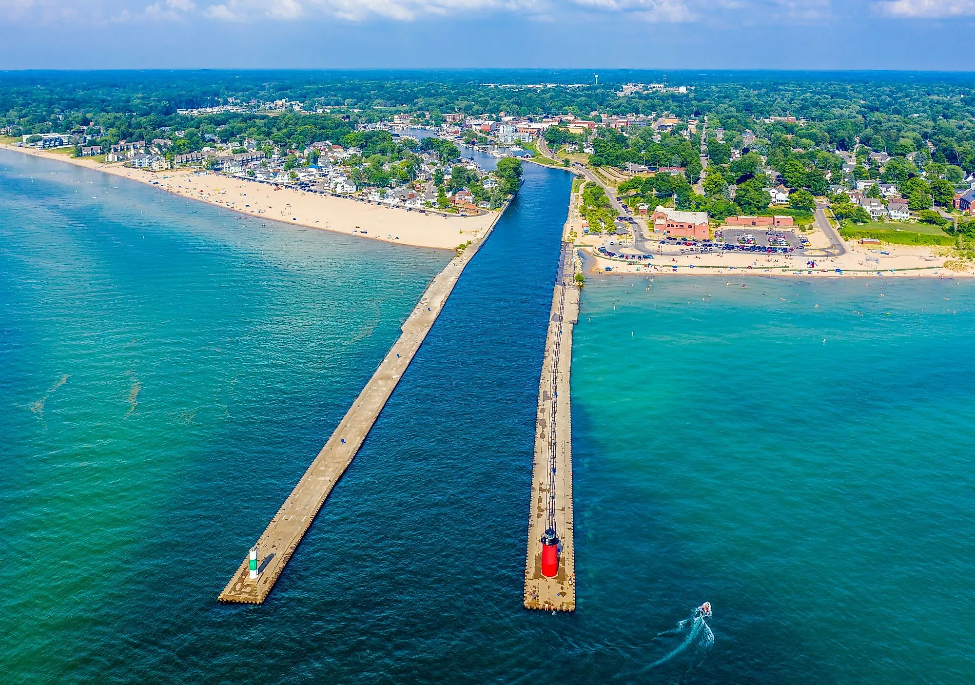
Ludington

Ludington, the Mason County seat in western Michigan, has about 7,800 residents and a working harbor that still launches the S.S. Badger, the largest passenger and car ferry running on the Great Lakes, on its daily four-hour run to Manitowoc, Wisconsin. The Badger is the last coal-fired steamship in regular service in the United States. The town has miles of beaches along Lake Michigan and Hamlin Lake, plus two lighthouses (one at the end of the breakwater you can walk out to). Ludington State Park, consistently ranked among the best in the Midwest, covers more than 5,000 acres of dunes, marsh, and pine forest north of town with the historic Big Sable Point Light at the northern end of its beach.
Copper Harbor

Copper Harbor, with around 100 year-round residents, is the northernmost community in Michigan, set at the very tip of the Keweenaw Peninsula on the shore of Lake Superior. The peninsula sits on one of the oldest exposed lava flows on the planet and is the only region in the United States where prehistoric copper mining has been documented (Indigenous peoples were extracting native copper here as far back as 7,000 years ago). The harbor itself is rocky rather than sandy, but Hunter's Point and Horseshoe Harbor open up flat shoreline walks. The Copper Harbor Trails system, built into the surrounding hills, has put the town on the international map for hard mountain biking and is the only IMBA-designated Silver Level Ride Center in the Midwest.
South Haven

With around 4,000 residents at the mouth of the Black River, South Haven runs along a working harbor with the South Haven Light at the end of its red catwalk-topped pier. South Beach, just south of the harbor entrance, has the town's main swim area; North Beach, on the opposite side of the river, is quieter and longer. Phoenix Street is the downtown commercial strip, with Taste at 402 Phoenix a longtime stop for grilled cheese, sandwiches, and tomato soup. The Michigan Maritime Museum on Dyckman Avenue holds tall ships including the schooner Friends Good Will, a working replica of an 1810 Great Lakes vessel.
Grand Haven

The Grand Haven Musical Fountain, set on Dewey Hill across the Grand River from downtown, runs free water-and-light shows nightly from Memorial Day through Labor Day and has been doing so since 1962, making it the oldest synchronized musical fountain in the country still in regular operation. Grand Haven, with around 10,000 residents, was the first city formally designated a Coast Guard City by Act of Congress, signed in 1998, in recognition of more than a century of close ties to the service. The Tri-Cities Historical Museum covers regional fur-trade and shipbuilding history, and Grand Haven State Park sits at the river's mouth on 48 acres of beachfront sand.
New Buffalo

In the southwest corner of Michigan near the Indiana line, New Buffalo draws weekenders out to its harbor, a wide white-sand public beach, and a marina that fills up through the summer. The town traces its founding to 1834, when sea captain Wessel Whittaker, headed for Chicago from Buffalo, New York, was shipwrecked along the coast and bought the surrounding land to build a town in his hometown's image. The Whittaker name still runs through the street grid and the Whittaker Woods Golf Club. New Buffalo Beach, a short walk from downtown, takes up the wide stretch of Lake Michigan shoreline at the harbor mouth.
Muskegon

The name Muskegon comes from an Algonquian word meaning "marshy river," and the town sits where the Muskegon River, the second-longest river in Michigan, empties into Muskegon Lake and on into Lake Michigan. With about 37,000 residents, Muskegon is the largest of these towns and holds onto a row of preserved Victorian-era mansions. The Hackley and Hume Historic Site keeps two adjoining 1880s lumber-baron homes open for tours, with stained glass, stenciled ceilings, and original woodwork. The Lakeshore Trail runs about twelve miles of paved path along Muskegon Lake and Lake Michigan. Pere Marquette Park, on the lakeshore, holds the South Pierhead Light at the harbor entrance and lines up with one of the longest unbroken Lake Michigan beaches in the state.
St. Joseph

St. Joseph sits on the bluffs at the mouth of the St. Joseph River in southwest Michigan, with about seven public beaches inside the city limits. Silver Beach, at the harbor mouth, is the most-used and pairs with the Silver Beach Carousel (a working 1910-style carousel built in 2010) and a public splash playground. The St. Joseph North Pier Lights, built in 1907, sit on the breakwater connected by a catwalk you can walk out to. About sixteen miles south, Warren Dunes State Park runs three miles of Lake Michigan shoreline and a row of high freshwater dunes used for sand-sliding and hang gliding.
Glen Arbor

Glen Arbor is a Leelanau Peninsula village of around 700 residents, set between Glen Lake and Lake Michigan inside the boundary of Sleeping Bear Dunes National Lakeshore. The downtown is one short main street of art galleries, kayak outfitters, and small restaurants, including Cherry Republic, a longtime regional retailer with a tasting room for cherry wines and ciders. Just outside town, the Crystal River winds through farmland and back into Lake Michigan, and the Sleeping Bear Bluffs rise more than 450 feet above the lake about four miles to the south. The Leelanau Peninsula Wine Trail starts a few minutes inland.
Cheboygan

Cheboygan, with about 4,800 residents, sits where the Cheboygan River meets Lake Huron at the head of the Inland Waterway, a chain of lakes and rivers running about 40 miles inland to Crooked Lake. Cheboygan State Park covers about 1,200 acres along the Lake Huron shoreline, with views of the Mackinac Bridge to the west on clear days and the abandoned Cheboygan Crib Light at the harbor entrance. Downtown holds a row of brick storefronts and the restored Cheboygan Opera House (built 1877, rebuilt 1888 after a fire), which still books touring shows.
Where the Great Lakes Touch Town
Across these eleven towns, Michigan's coastline shows up differently at every stop. The wide white-sand beaches of the southwest. The dune-walled bays of the Lower Peninsula. The working harbors at the river mouths. The rocky shorelines and old mining country of the Keweenaw. None of them are big, and most of them go quiet by the end of October, but the lake doesn't, and the shoreline rewards the drive in every season.